Sold"Strip" Map Panorama of the Maine Panorama of the Maine and the Adjacent Country, from Mayence to Frankfort, Drawn from Nature by F.W. Delkeskamp, Engraved by John Clark; Accompanied with a Description of the Places on each Bank of tSee Sold Price
SoldCivil War Map Panorama of the Mississippi Valley andCivil War Map Panorama of the Mississippi Valley and its Fortifications Panorama of the Mississippi Valley and its Fortifications. New York: Charles Magnus, publ., 1863. Approx. 24 x 26 in. Strip maSee Sold Price
SoldA 16th Century Map / Panorama of Vilnius, Lithuania,Published c. 1599, Braun & Hogenberg, map title ‘VILNA LITVANIAE’, Latin text to verso, uncoloured, paper with slight trim to edge, with old tape marks to edge, no restoration, dimensionsSee Sold Price
SoldPOMPEII antique town city map & panorama. Domus Pansae;TITLE/CONTENT OF MAP: 'POMPEII.; inset Domus Pansae; plan of the coast in the vicinity of Vesuvius' DATE PRINTED: This map was originally published by Baldwin & Cradock in 1832; this date is printed oSee Sold Price
SoldPOCKET MAP-PANORAMA OF THE HUDSON RIVER Wade-CroomPOCKET MAP-PANORAMA OF THE HUDSON RIVER Wade-Croome with a folding map of the Hudson River from New York City to Albany, the map 5 3/4" x 144" 1845 Shipping Information: Shipping within the ContinentSee Sold Price
SoldMAPS - Maine. U.S. Gov.Maine. U.S. Gov., [Lot of 2] Map of the Northern Part of the State of Maine and of the Adjacent British Provinces... [and] Extract from a Map of the British and French Dominions in North America, 1838See Sold Price
Sold19TH CENTURY FRENCH MAP, MAINE ET LOIRE, FRAMEDAristide Michel Perrot (French, 1793-1879). "Maine et Loire", engraving. Signed Perrot and engraver Pierre Tardieu in plate. Approx. 13" x 14.5" (frame), 3.75" 5.25" (sight) Item from the Estate of FoSee Sold Price
SoldOgilby strip map of English roadHeading: (Great Britain) Author: Ogilby, John Title: The Continuation of the Extended Road from Buckingham to Bridgnorth in Com Salop… Place Published: London Publisher: Date Published: 1675<See Sold Price
SoldStrip map of English roads, 1775Title: The Road from London to Barnstable, in Devon Shire, commencing at Andover, in ye Road to ye Lands End, also from Barnstable to Truro Author: Gentleman's Magazine Description: Copper-engraved maSee Sold Price
Sold17TH CENTURY ENGLISH "STRIP MAP".The road from King's Lyn Norf to Harwich..., by John Ogilby, "His Ma[jes]ties Cosmographer", London, 1675, hand colored engraving paper. Toning, minor foxing, minor losses. 14 1/4"h. 18"w. Ogilby publSee Sold Price
C. A. M. A. Strip Map Service [New Mexico, Arizona]Title: C. A. M. A. Strip Map Service [New Mexico, Arizona] Publication Date: c1930 Cartographer: Publisher: California Automobile Map Agency Size: 3.5X8.5 El Paso, New Mexico, Arizona accommodations oSee Sold Price
Sold16 ft. strip map of west coast 1931Heading: (West Coast) Author: Aristocrat, Inc., The Title: The Aristocrat, Inc.; Canada, Vancouver B.C., Seattle, Portland, Sacramento, San Francisco, Los Angeles, San Diego, Tia Juana, Mexico Place PSee Sold Price
SoldMap: '' The Road from London to Carlisle '' strip mapMap: '' The Road from London to Carlisle '' strip map from the 'Britannia' by John Ogilby, first published in 1675 with later hand colouring, this was map number 37 of 100 from the atlas.See Sold Price
Sold1833 French wine atlas map Maine et Loire1833 French wine atlas map Maine et Loire. Framed size 33"h x 29.5"wSee Sold Price
Sold16 ft. strip map of west coastHeading: Author: Aristocrat, Inc., The Title: The Aristocrat, Inc.; Canada, Vancouver B.C., Seattle, Portland, Sacramento, San Francisco, Los Angeles, San Diego, Tia juana, Mexico Place Published: PoSee Sold Price
Color woodblock strip map of Japan, c.1854Title: Color woodblock strip map of Japan, Edo Period Author: ** Description: Color woodblock strip map. Approx. 350x38 cm. (137x15"); folding to 7¼x3¾".Captivating strip map of the Japanese home isSee Sold Price
SoldStrip maps of RR route from SF to Chicago 1878Title: San Francisco to Chicago Via the Burlington Route Author: ** Description: Lithographed map, folding. Overall 38x80 cm. (15x31½").Consists of three strip maps showing the route and every stop,See Sold Price
Sold18th century strip map of Abingdon,18th century strip map of Abingdon, Oxfordshire, 10" x 5"See Sold Price
SoldPOMPEII Antique city town map panorama Domus Pansae BayTITLE/CONTENT OF MAP: 'POMPEII.; inset Domus Pansae; plan of the coast in the vicinity of Vesuvius' The top image on the right hand side shows the entire map. To view a close up of the map showing theSee Sold Price
SoldJohn Ogilby, strip map Bristol to Banbury, engravingJohn Ogilby, strip map Bristol to Banbury, engraving circa 1698, 35cm x 47cm, framedSee Sold Price
SoldA monochromatic strip map 'The Continuation of the RoadA monochromatic strip map 'The Continuation of the Road from London to the Lands-end' by J. Ogleby. 34 x 48cm.See Sold Price
SoldOgilby strip map of Road from LondonTitle: The Road from London to Flambourough Head in Com Ebor... Containing 212 mile 6 Furlongs... Author: Ogilby, John Description: Copper-engraved strip map. 34.5x43 cm. (13½x17"), matted & framed uSee Sold Price
SoldA handtinted coloured strip map, 'The road from ExeterA handtinted coloured strip map, 'The road from Exeter to Truroe' by J. Ogleby c1679, 34 x 45cmSee Sold Price
1856 wall map, Maine, Kennebec County1856 wall map, Maine, Kennebec County. 57" x 59" Published by J. Chance, Philadelphia.See Sold Price
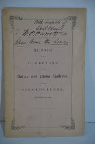
Boston and Maine RR Annual Report-September 12, 1849JM Hobby Supply and Railroad Artifact Auctions4.4(126)See Sold PriceFeb 24, 2024
Eastern RR Summer Book of Tours-1884JM Hobby Supply and Railroad Artifact Auctions4.4(126)See Sold PriceFeb 24, 2024
Grand Trunk Railroad Across the Continent Through Canada Book-1917JM Hobby Supply and Railroad Artifact Auctions4.4(126)See Sold PriceFeb 24, 2024
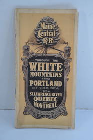
Maine Central RR Through the White Mtns-Portland to the St Lawrence River Book-1901JM Hobby Supply and Railroad Artifact Auctions4.4(126)See Sold PriceFeb 24, 2024
ROBERT BROWNING Rare 1902 LE "Pippa Passes" Calf Binding 1st EdLuis Porretta Fine Arts4.3(10)See Sold PriceMar 02, 2024
17TH C. MAP OF THE BERKSHIRES BY JOHN SPEED, FRAMEDThomaston Place Auction Galleries4.4(386)See Sold PriceFeb 24, 2024
18TH C. ANTIQUE MAP: FRENCH & INDIAN WAR, FRAMEDThomaston Place Auction Galleries4.4(386)See Sold PriceFeb 24, 2024
NICOLAES VISSCHER (NETHERLANDS, 1618-1709) MAP OF THE NEW WORLDThomaston Place Auction Galleries4.4(386)See Sold PriceFeb 24, 2024
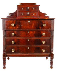
FANCIFUL STATE of MAINE SHERATON MAHOGANY DRESSERJohn McInnis Auctioneers,LLC4.6(502)See Sold PriceFeb 25, 2024
"WINTER AND SUMMER IN MAINE" 1904 PHOTO ALBUMJohn McInnis Auctioneers,LLC4.6(502)See Sold PriceFeb 25, 2024
Rand McNally Railroad Map Cabinet w/ 21 Railroad MapsRail & Road Auctions4.6(165)See Sold PriceMar 08, 2024
NEEDFUL THINGS (1993) - "Mickey Mantle" Baseball Card with Mouse Trap and Shopping BagPropstore4.2(6)See Sold PriceMar 14, 2024
Panoramas & Peepshow.- Aliquis. The Flight of the Old Woman who was Tossed up in a Basket,Forum Auctions4.3(52)See Sold PriceFeb 29, 2024


![C. A. M. A. Strip Map Service [New Mexico, Arizona] (1 of 2)](https://p1.liveauctioneers.com/5584/131651/66922867_1_x.jpg?height=282&quality=70&version=1543357078)