SoldStrip map of English roads, 1775Title: The Road from London to Barnstable, in Devon Shire, commencing at Andover, in ye Road to ye Lands End, also from Barnstable to Truro Author: Gentleman's Magazine Description: Copper-engraved maSee Sold Price
Strip map of English roads, 1775Title: The Road from London to Barnstable, in Devon Shire, commencing at Andover, in ye Road to ye Lands End, also from Barnstable to Truro Author: Gentleman's Magazine Description: Copper-engraved maSee Sold Price
SoldOgilby strip map of English roadHeading: (Great Britain) Author: Ogilby, John Title: The Continuation of the Extended Road from Buckingham to Bridgnorth in Com Salop… Place Published: London Publisher: Date Published: 1675<See Sold Price
JOHN OGILBY ENGLISH ROAD MAP LONDON TO HARWICHJOHN OGILBY ENGLISH ROAD MAP, LONDON TO HARWICH, H 13" W 17":Strip map framed in Knightsbridge by Edward Baynton Ltd.See Sold Price
Sold17TH CENTURY ENGLISH "STRIP MAP".The road from King's Lyn Norf to Harwich..., by John Ogilby, "His Ma[jes]ties Cosmographer", London, 1675, hand colored engraving paper. Toning, minor foxing, minor losses. 14 1/4"h. 18"w. Ogilby publSee Sold Price
SoldJohn Senex The Road from London to BristolJohn Senex The Road from London to Bristol,engraved strip road map, including A Branch from Banbury to Campden, in Gloucestershire, with hand-colouring, c.1775, [Sayer & Bennett], 300 x 375mm.See Sold Price
Early English strip-syle road mapsTitle: Lot of 5 strip-style road maps Author: Universal Magazine Description: Includes: The Road from London to Aberistwith on the Sea Coast of Cardigan Shire... * The Road from London to Arundel... [See Sold Price
SoldOgilby & Senex The Roads through EnglandOgilby (John and John Senex) The Roads through England or, Ogilby's Survey Revised, Improved, and Reduced,engraved title, general map, and 101 strip road maps, title in French and English, damSee Sold Price
Sold[Map] English Road Map18th century; watercolored, London to Barwick, framed 23 in. L., 19 in. H.See Sold Price
SoldOgilby strip map of Road from LondonTitle: The Road from London to Flambourough Head in Com Ebor... Containing 212 mile 6 Furlongs... Author: Ogilby, John Description: Copper-engraved strip map. 34.5x43 cm. (13½x17"), matted & framed uSee Sold Price
SoldA handtinted coloured strip map, 'The road from ExeterA handtinted coloured strip map, 'The road from Exeter to Truroe' by J. Ogleby c1679, 34 x 45cmSee Sold Price
Early English road map by John OgilbyHeading: (Maps) Author: Ogilby, John Title: The Road from London to St. Neotts in Com. Hunt. Continued to Oakeham in Com Rutland Place Published: London Publisher: Date Published: 1675See Sold Price
SoldTwo Old English Road MapsTwo Old English Road Maps by John Ogilby, published London, 1675-1698, the first "The Roads from London, to Wells in Norfolk and St. Edmons Bury in Suffolk..."; pl. 13" x 17-5/8"; the second "The RoadSee Sold Price
SoldEarly English road map by John OgilbyHeading: Author: Ogilby, John Title: The Road from London to Newhaven Com. Suffex... Continued From Newhaven... to Brighthelmeston... to New-Shoreham Place Published: London Publisher: Date PublSee Sold Price
SoldOld English Road Map by OgilbyHeading: (Britain) Author: Ogilby, John Title: The Road From Huntingdon to Ipswich Co. Suff. Place Published: London Publisher: Date Published: 1675 Description: Copper-engrSee Sold Price
Rare, Late 1700's English Road Maps, London to Eastc.1790 English hand-colored road maps showing the journey from London to East Grinsted. Published by J. Cary. Map shows The Thames, London Bridge, Blackfriar's Bridge & including pubs & inns along theSee Sold Price
Rare, Late 1700's English Road Maps, London to Eastc.1790 English hand-colored road maps showing the journey from London to East Grinsted. Published by J. Cary. Map shows The Thames, London Bridge, Blackfriar's Bridge & including pubs & innsSee Sold Price
SoldJohn Ogilby (1600-1676), two coloured strip road maps, 'Bristol to Worcester' and 'Bristol toJohn Ogilby (1600-1676), two coloured strip road maps, 'Bristol to Worcester' and 'Bristol to Exeter', each 36 cm x 44 cm, together with a Georg Hoefnagel hand-coloured map of Brightstowe (Bristol), 3See Sold Price
Early English road map by John OgilbyHeading: Author: Ogilby, John Title: The Road from London to St. Neotts in Com. Hunt. Continued to Oakeham in Com Rutland Place Published: London Publisher: Date Published: 1675 DescriSee Sold Price
Early English road map by John OgilbyHeading: Author: Ogilby, John Title: The Road from London to Newhaven Com. Suffex... Continued From Newhaven... to Brighthelmeston... to New-Shoreham Place Published: London Publisher: Date PublSee Sold Price
Rare, Late 1700's English Road Maps, London to Eastc.1790 English hand-colored road maps showing the journey from London to East Grinsted. Published by J. Cary. Map shows The Thames, London Bridge, Blackfriar's Bridge & including pubs & inns along theSee Sold Price
SoldMaps: Three road strip maps, comprising the Road fromMaps: Three road strip maps, comprising the Road from London to Buckingham after John Ogilby, a hand coloured example of the same route, and a hand coloured strip map with a survey of the road from GlSee Sold Price
SoldMap: An 18thC hand coloured engraved road strip map ofMap: An 18thC hand coloured engraved road strip map of Cornwall, showing the route from Tregony to Penzance, after John Owen and Emanuel Bowen, with the Arms of Tregony. Approx. 7 1/4" x 4 3/4"See Sold Price
SoldOGILBY, JOHN COLOR ETCHINGS OF ROAD STRIP MAPSJOHN OGILBY, COLOR ETCHINGS OF ROAD STRIP MAPS, 4 PCS., 12" - 14" H. X 17" W.:four double page, color engravings of road strip maps entitled: "The Road From London to Oakeham", "The Road From London tSee Sold Price
17TH C. ENGLISH LINEAR MAP BY OGILBY, FRAMEDThomaston Place Auction Galleries4.4(386)See Sold PriceFeb 24, 2024
Westland Oil Company North Dakota Road MapCheck the Oil Promotions, LLC4.6(275)See Sold PriceFeb 25, 2024
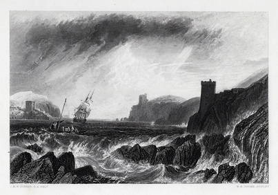
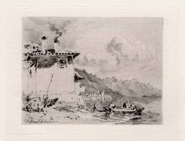
John Fullwood (English 1854-1931) Etching English Road and River SignedGlobal Auctions Company4.3(36)See Sold PriceMar 03, 2024
Joseph Mallord William Turner Val D'Aosta 1885 engravingKCM Galleries4.7(164)See Sold PriceFeb 25, 2024
1800s William Turner Engraving Dido Building Carthage Signed FramedKCM Galleries4.7(164)See Sold PriceFeb 25, 2024
SIGNED JMW TURNER 1800s Engraving Fowey Harbour, England FRAMEDKCM Galleries4.7(164)See Sold PriceFeb 25, 2024
Joseph Mallord William Turner 1877 etching Coastal Landscape signedKCM Galleries4.7(164)See Sold PriceFeb 25, 2024
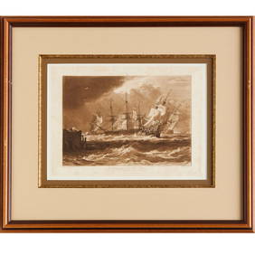
Joseph Mallord William Turner 1874 etching The Sun of Venice going to Sea signedKCM Galleries4.7(164)See Sold PriceFeb 25, 2024
1800s JMW TURNER Engraving Michael's Mount, Cornwall SIGNED FramedKCM Galleries4.7(164)See Sold PriceFeb 25, 2024
WILLIAM TURNER 1800s Engraving View of Ingleborough SIGNED FramedKCM Galleries4.7(164)See Sold PriceFeb 25, 2024
William Turner 1800s Engraving St Mary's Church, Brignall Signed FramedKCM Galleries4.7(164)See Sold PriceFeb 25, 2024
1800s JMW TURNER Engraving "Line Fishing off Hastings" SIGNED FramedKCM Galleries4.7(164)See Sold PriceFeb 25, 2024
JMW TURNER 1800s Engraving Bacchus and Ariadne SIGNED FramedKCM Galleries4.7(164)See Sold PriceFeb 25, 2024
Joseph Mallord William Turner 1863 Engraving Yarmouth signedKCM Galleries4.7(164)See Sold PriceFeb 25, 2024
1800s JMW TURNER Engraving View of Thames FRAMED SignedKCM Galleries4.7(164)See Sold PriceFeb 25, 2024


![[Map] English Road Map (1 of 4)](https://p1.liveauctioneers.com/523/84219/43476550_1_x.jpg?height=282&quality=70&version=1453240168)