ATLAS of ANTIENT GEOGRAPHY by SAMUEL BUTLER 1843John McInnis Auctioneers,LLC4.6(502)See Sold PriceFeb 24, 2024
18TH C. ANTIQUE MAP: FRENCH & INDIAN WAR, FRAMEDThomaston Place Auction Galleries4.4(386)See Sold PriceFeb 24, 2024
Rand McNally Railroad Map Cabinet w/ 21 Railroad MapsRail & Road Auctions4.6(165)See Sold PriceMar 08, 2024
Keith Haring - Ink on New York Map, Best Buddies, Inscribed, Signed, and DatedSapphire Auction Gallery4(67)See Sold PriceMar 02, 2024
LATE 17TH C. FRENCH MAP OF THE NEW WORLD BY ALEXIS-HUBERT JAILLOT (1632-1712)Thomaston Place Auction Galleries4.4(386)See Sold PriceFeb 24, 2024
Central Railroad of New Jersey Map of Sandy Hook Route-ca. 1903JM Hobby Supply and Railroad Artifact Auctions4.4(126)See Sold PriceFeb 24, 2024
Lot of Six Mixed Atlas Box Cars-HO Scale-New in BoxJM Hobby Supply and Railroad Artifact Auctions4.4(126)See Sold PriceFeb 25, 2024
Rand McNally/Santa Fe Railroad Map of Iowa-1912JM Hobby Supply and Railroad Artifact Auctions4.4(126)See Sold PriceFeb 24, 2024
NICOLAES VISSCHER (NETHERLANDS, 1618-1709) MAP OF THE NEW WORLDThomaston Place Auction Galleries4.4(386)See Sold PriceFeb 24, 2024
17TH C. WORLD MAP BY NICOLAES VISSCHER (NETHERLANDS, 1618-1709)Thomaston Place Auction Galleries4.4(386)See Sold PriceFeb 24, 2024
Lot of Six Mixed Atlas Cabooses-HO Scale-New in BoxJM Hobby Supply and Railroad Artifact Auctions4.4(126)See Sold PriceFeb 25, 2024
"Southern provinces of the United States". THOMSON.TITLE/CONTENT OF MAP: 'Southern provinces of the United States' The map shows the United States including the first 17 states to acceed, including Tennessee, which had joined in 1796. Ohio, LouisianaSee Sold Price
SoldSouthern provinces of the United States. THOMSON. WestTITLE/CONTENT OF MAP: 'Southern provinces of the United States' The map shows the United States including the first 17 states to acceed, including Tennessee, which had joined in 1796. Ohio, LouisianaSee Sold Price
Southern provinces of the United States. THOMSON. WestTITLE/CONTENT OF MAP: 'Southern provinces of the United States' The map shows the United States including the first 17 states to acceed, including Tennessee, which had joined in 1796. Ohio, LouisianaSee Sold Price
"Southern provinces of the United States". THOMSON.TITLE/CONTENT OF MAP: 'Southern provinces of the United States' The map shows the United States including the first 17 states to acceed, including Tennessee, which had joined in 1796. Ohio, LouisianaSee Sold Price
"Southern provinces of the United States". THOMSON.TITLE/CONTENT OF MAP: 'Southern provinces of the United States' The map shows the United States including the first 17 states to acceed, including "Tenasee" (Tennessee), which had joined in 1796. OhioSee Sold Price
"Southern provinces of the United States". THOMSON.TITLE/CONTENT OF MAP: 'Southern provinces of the United States' The map shows the United States including the first 17 states to acceed, including "Tenasee" (Tennessee), which had joined in 1796. OhioSee Sold Price
Southern provinces of the United States. THOMSON. West & East Florida 1817 mapTitle: "Southern provinces of the United States". THOMSON. West & East Florida 1817 map Description: Southern provinces of the United States' by Drawn & engraved by Nathaniel Robert Hewitt for John ThSee Sold Price
SoldThomson Map of the American S.E.THOMSON, John (c. 1777 - 1840). Southern Provinces of the United States. Thomson's New General Atlas. Engraving with original hand color. Edinburgh: 1817. 21 1/4" x 26" sheet. In the early nineteenthSee Sold Price
SoldThree early 19th century U.S. mapsThree early 19th century U.S. maps: "Southern Provinces of the United States", John Thomson, 1815, inset Hudson River scene, 19-3/4 x 23-1/2 in. (sight); "Carte Generale des Etats-Unis", E. Mentelle aSee Sold Price
Sold19th Century Map of the Eastern UnitedStates [The Southern Provinces of the United States,] from John Thomson's [New General Atlas,] Edinburgh, 1817, showing towns, geographical features, and Native American tribes in the southern and midSee Sold Price
SoldMap of the Southern Province of U.S. 1817An Antique Hand-Colored Map of the Southern Provinces of the United States, 1817, from Thomson's New General Atlas, copper-engraved map, sheet 21 1/2 in. x 28 3/4 inSee Sold Price
Thomson: Antique Map of Southern United States, 1817Southern provinces of the United States' The map shows the United States including the first 17 states to acceed, including Tennessee, which had joined in 1796. Ohio, Louisiana and Indiana, which hadSee Sold Price
SoldThomson: Antique Map of Southeastern United States 1817Southern Provinces of the United States A beautiful exemplar of the southern United States map from Thomson's New General Atlas, with a lovely inset view of "Characteristic Scenery of the Hudson RiverSee Sold Price
SoldJOHN THOMSON (Scottish 1777-circa 1840) A HAND COLOREDJOHN THOMSON (Scottish 1777-circa 1840) A HAND COLORED MAP, "Southern Provinces of the United States," 1817, with an engraved view at the upper left quadrant of "Characteristic Scenery of the Hudson RSee Sold Price
SoldMap, Southern Provinces of the United StatesMap, Southern Provinces of the United Stateshand colored engraving, Plate 57 from John Thomson's NEW GENERAL ATLAS (Edinburgh: John Thomson & Co., 1817), upper left carries Hudson River view. PresenteSee Sold Price
Thomson: Antique Map of Southwest United States, 1817TITLE/CONTENT OF MAP: 'Southern provinces of the United States' The map shows the United States including the first 17 states to acceed, including Tennessee, which had joined in 1796. Ohio, LouisianaSee Sold Price
Thomson: Antique Map of Southern provinces of USTITLE/CONTENT OF MAP: 'Southern provinces of the United States' The map shows the United States including the first 17 states to acceed, including Tennessee, which had joined in 1796. Ohio, LouisianaSee Sold Price
SoldMap, "The Southern Provinces of the United States"Map, "The Southern Provinces of the United States" hand colored engraving, Plate 57 from John Thomson's NEW GENERAL ATLAS (Edinburgh: John Thomson & Co., 1817). Presented in wooden frame. DOA 22 x 29See Sold Price
SoldThomson/Hewitt Map, 1817 Southern Provinces of US"Map of the Southern Provinces of the United States", drawn and engraved by N. R. Hewitt, published by John Thomson, Edinburgh, John Cumming, Dublin, and Baldwin, Cradock, and Joy, London, 1817. FromSee Sold Price
SoldMap, "Southern Provinces of the United States"Map, "Southern Provinces of the United States" drawn and engraved for Thomnon's New General Atlan - 1817 - 51 1/2" x 21 1/2"See Sold Price
SoldNorthern provinces of the United States. THOMSON.TITLE/CONTENT OF MAP: 'Northern provinces of the United States' The map shows the "District of Maine", prior to its accession to the Union as the state of Maine in 1820. Some Native American Indian viSee Sold Price
SoldSouthern Provinces of the United StatesThompson, Southern Provinces of the United States, 1817, 23.5 x 20 23.5 x 20See Sold Price
"Northern provinces of the United States". THOMSON.TITLE/CONTENT OF MAP: 'Northern provinces of the United States' The map shows the "District of Maine", prior to its accession to the Union as the state of Maine in 1820. Some Native American Indian viSee Sold Price
Sold"Northern provinces of the United States". THOMSON.TITLE/CONTENT OF MAP: 'Northern provinces of the United States' The map shows the "District of Maine", prior to its accession to the Union as the state of Maine in 1820. The top image on the right hanSee Sold Price
1950 Menaboni Bird Lithograph, Boat-tailed GrackleConnoisseur Auctions4(333)See Sold PriceFeb 24, 2024
ELVIS PRESLEY RCA 45 AN AMERICAN TRILOGY/THE FIRST TIME EVER I SAW PB 74-0672King's Auctions Inc4.2(121)See Sold PriceMar 03, 2024
1950 Menaboni Print, Black Duck ( Black / White )Connoisseur Auctions4(333)See Sold PriceMar 02, 2024
Vintage 1950 Color Lithograph, Eastern Wild TurkeyConnoisseur Auctions4(333)See Sold PriceMar 02, 2024
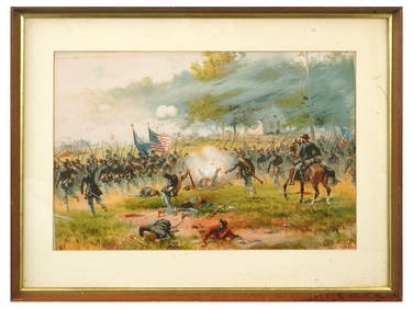
ANTIQUE AMERICAN CIVIL WAR LITHO BY THURE DE THULSTRUPAntique Arena Inc.4.5(852)See Sold PriceFeb 24, 2024
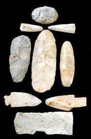
Choice Florida Agatized Coral Geode & Botryoidal CavityArtemis Fine Arts4.8(1.4k)See Sold PriceMar 01, 2024