ATLAS of ANTIENT GEOGRAPHY by SAMUEL BUTLER 1843John McInnis Auctioneers,LLC4.6(502)See Sold PriceFeb 24, 2024
18TH C. ANTIQUE MAP: FRENCH & INDIAN WAR, FRAMEDThomaston Place Auction Galleries4.4(386)See Sold PriceFeb 24, 2024
Rand McNally Railroad Map Cabinet w/ 21 Railroad MapsRail & Road Auctions4.6(165)See Sold PriceMar 08, 2024
Keith Haring - Ink on New York Map, Best Buddies, Inscribed, Signed, and DatedSapphire Auction Gallery4(67)See Sold PriceMar 02, 2024
LATE 17TH C. FRENCH MAP OF THE NEW WORLD BY ALEXIS-HUBERT JAILLOT (1632-1712)Thomaston Place Auction Galleries4.4(386)See Sold PriceFeb 24, 2024
Central Railroad of New Jersey Map of Sandy Hook Route-ca. 1903JM Hobby Supply and Railroad Artifact Auctions4.4(126)See Sold PriceFeb 24, 2024
Lot of Six Mixed Atlas Box Cars-HO Scale-New in BoxJM Hobby Supply and Railroad Artifact Auctions4.4(126)See Sold PriceFeb 25, 2024
Rand McNally/Santa Fe Railroad Map of Iowa-1912JM Hobby Supply and Railroad Artifact Auctions4.4(126)See Sold PriceFeb 24, 2024
NICOLAES VISSCHER (NETHERLANDS, 1618-1709) MAP OF THE NEW WORLDThomaston Place Auction Galleries4.4(386)See Sold PriceFeb 24, 2024
17TH C. WORLD MAP BY NICOLAES VISSCHER (NETHERLANDS, 1618-1709)Thomaston Place Auction Galleries4.4(386)See Sold PriceFeb 24, 2024
Lot of Six Mixed Atlas Cabooses-HO Scale-New in BoxJM Hobby Supply and Railroad Artifact Auctions4.4(126)See Sold PriceFeb 25, 2024
Southern provinces of the United States. THOMSON. West & East Florida 1817 mapTitle: "Southern provinces of the United States". THOMSON. West & East Florida 1817 map Description: Southern provinces of the United States' by Drawn & engraved by Nathaniel Robert Hewitt for John ThSee Sold Price
Southern provinces of the United States. THOMSON. West & East Florida 1830 mapTitle: "Southern provinces of the United States". THOMSON. West & East Florida 1830 map Description: Southern provinces of the United States' by Drawn & engraved by Nathaniel Robert Hewitt for John ThSee Sold Price
Thomson (John) - Southern Provinces of the Unitedeastern United States from Lake Erie to northern Florida, and west to Louisiana, inset view of 'Characteristic Scenery on the Hudson River', upper left, engraved map with original hand-colouring, 500See Sold Price
SoldSouthern provinces of the United States. THOMSON. WestTITLE/CONTENT OF MAP: 'Southern provinces of the United States' The map shows the United States including the first 17 states to acceed, including Tennessee, which had joined in 1796. Ohio, LouisianaSee Sold Price
Southern provinces of the United States. THOMSON. WestTITLE/CONTENT OF MAP: 'Southern provinces of the United States' The map shows the United States including the first 17 states to acceed, including Tennessee, which had joined in 1796. Ohio, LouisianaSee Sold Price
SoldMap of the Southern Province of U.S. 1817An Antique Hand-Colored Map of the Southern Provinces of the United States, 1817, from Thomson's New General Atlas, copper-engraved map, sheet 21 1/2 in. x 28 3/4 inSee Sold Price
Sold19th Century Map of the Eastern UnitedStates [The Southern Provinces of the United States,] from John Thomson's [New General Atlas,] Edinburgh, 1817, showing towns, geographical features, and Native American tribes in the southern and midSee Sold Price
SoldAmerica.- Colonial Southern United States, Florida.-NO RESERVE America.- Colonial Southern United States, Florida.- Gibson (John) A Map of the New Governments, of East & West Florida, with inset plan of the Harbour and Settlement of Pensacola, publisheSee Sold Price
SoldThomson Map of the American S.E.THOMSON, John (c. 1777 - 1840). Southern Provinces of the United States. Thomson's New General Atlas. Engraving with original hand color. Edinburgh: 1817. 21 1/4" x 26" sheet. In the early nineteenthSee Sold Price
SoldThomson/Hewitt Map, 1817 Southern Provinces of US"Map of the Southern Provinces of the United States", drawn and engraved by N. R. Hewitt, published by John Thomson, Edinburgh, John Cumming, Dublin, and Baldwin, Cradock, and Joy, London, 1817. FromSee Sold Price
SoldMap, Southern Provinces of the United StatesMap, Southern Provinces of the United Stateshand colored engraving, Plate 57 from John Thomson's NEW GENERAL ATLAS (Edinburgh: John Thomson & Co., 1817), upper left carries Hudson River view. PresenteSee Sold Price
SoldMap, "The Southern Provinces of the United States"Map, "The Southern Provinces of the United States" hand colored engraving, Plate 57 from John Thomson's NEW GENERAL ATLAS (Edinburgh: John Thomson & Co., 1817). Presented in wooden frame. DOA 22 x 29See Sold Price
Thomson: Antique Map of Southern United States, 1817Southern provinces of the United States' The map shows the United States including the first 17 states to acceed, including Tennessee, which had joined in 1796. Ohio, Louisiana and Indiana, which hadSee Sold Price
SoldThomson: Antique Map of Southeastern United States 1817Southern Provinces of the United States A beautiful exemplar of the southern United States map from Thomson's New General Atlas, with a lovely inset view of "Characteristic Scenery of the Hudson RiverSee Sold Price
Thomson: Antique Map of Southwest United States, 1817TITLE/CONTENT OF MAP: 'Southern provinces of the United States' The map shows the United States including the first 17 states to acceed, including Tennessee, which had joined in 1796. Ohio, LouisianaSee Sold Price
SoldJOHN THOMSON (Scottish 1777-circa 1840) A HAND COLOREDJOHN THOMSON (Scottish 1777-circa 1840) A HAND COLORED MAP, "Southern Provinces of the United States," 1817, with an engraved view at the upper left quadrant of "Characteristic Scenery of the Hudson RSee Sold Price
Sold2 Maps, incl: Map of the Northern & MIddle States[United States]. 2 Maps. ++ A Map Of The States Of Virginia, North Carolina, South Carolina And Georgia: Comprehending the Spanish Provinces of East and West Florida: Exhibiting the Boundaries as fixeSee Sold Price
SoldA New Map of the States of Virginia North Carolina...and Georgia Comprehending the Spanish Provinces of East and West Florida Exhibiting the boundaries between the United States and Spanish Dominions as fixed by the Treaty of Peace in 1783 / CompiledSee Sold Price
Map of Gulf of Mexico and Caribbean showing Texas, 1874S. Augustus Mitchell map of the southern portion of the United States showing the area from North Carolina and Florida in the east to New Mexico in the West. West Indies, Cuba, Jamaica, Haiti and DomiSee Sold Price
Northern provinces of the United States. THOMSON. District of Main[e] 1817 mapTitle: "Northern provinces of the United States". THOMSON. District of Main[e] 1817 map Description: Northern provinces of the United States' by Drawn & engraved by Nathaniel Robert Hewitt for John ThSee Sold Price
"Southern provinces of the United States". THOMSON.TITLE/CONTENT OF MAP: 'Southern provinces of the United States' The map shows the United States including the first 17 states to acceed, including Tennessee, which had joined in 1796. Ohio, LouisianaSee Sold Price
"Southern provinces of the United States". THOMSON.TITLE/CONTENT OF MAP: 'Southern provinces of the United States' The map shows the United States including the first 17 states to acceed, including Tennessee, which had joined in 1796. Ohio, LouisianaSee Sold Price
"Southern provinces of the United States". THOMSON.TITLE/CONTENT OF MAP: 'Southern provinces of the United States' The map shows the United States including the first 17 states to acceed, including "Tenasee" (Tennessee), which had joined in 1796. OhioSee Sold Price
1817 Southern Provinces of the United StatesThis is a scarce first edition of John Thomson’s 1817 map of the southeastern part of the United States, with outline coloring. The map covers from the Mississippi River eastward to the AtlantiSee Sold Price
Cincinnati Hamilton and Dayton RR Map -USGC 1889JM Hobby Supply and Railroad Artifact Auctions4.4(126)See Sold PriceFeb 24, 2024
Northern Pacific RR Washington and Northern Idaho Map Folder-1941JM Hobby Supply and Railroad Artifact Auctions4.4(126)See Sold PriceFeb 24, 2024
"THE PRESIDENTS OF THE UNITED STATES" N. CURRIERJohn McInnis Auctioneers,LLC4.6(502)See Sold PriceFeb 25, 2024
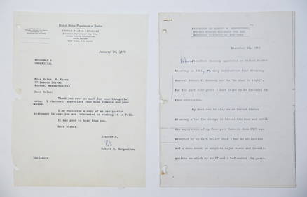
1969 RESIGNATION of ROBERT M. MORGENTHAUJohn McInnis Auctioneers,LLC4.6(502)See Sold PriceFeb 25, 2024
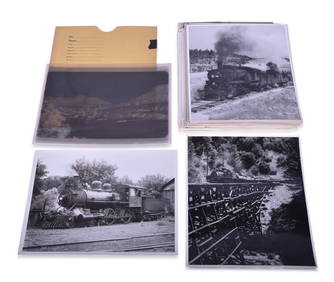
Seventy-Three Black and White Railroad Photographs and Film NegativesRail & Road Auctions4.6(165)See Sold PriceMar 07, 2024
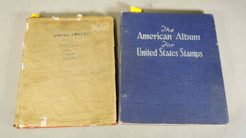
Two Stamp Albums: "United States of America" & World Stamp CollectionNeo FineArts Inc4.4(12)See Sold PriceFeb 25, 2024
Rand McNally Railroad Map Cabinet w/ 21 Railroad MapsRail & Road Auctions4.6(165)See Sold PriceMar 08, 2024
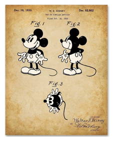
WALT DISNEY Mickey Mouse U.S. Patent Office Art PrintSouth Florida Auction & Estate Sale Services Inc4.5(520)See Sold PriceMar 08, 2024
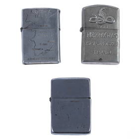
WWII Korea & Vietnam Era Silver Lighters 3pc LOTHill Auction Gallery 4.7(1k)See Sold PriceFeb 28, 2024
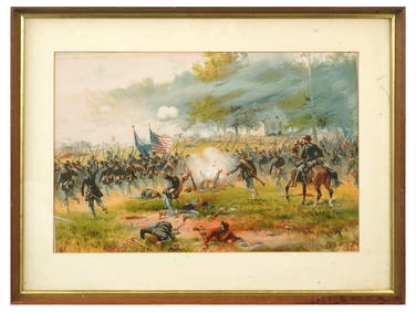
ANTIQUE AMERICAN CIVIL WAR LITHO BY THURE DE THULSTRUPAntique Arena Inc.4.5(852)See Sold PriceFeb 24, 2024
[ARCTIC]. BOWEN, Emanuel. A New & Accurate Map of the North...Potter & Potter Auctions4.6(539)See Sold PriceMar 07, 2024
[BUSINESS]. Travel Guide of Negro Hotels and Guest Houses. Published by Afro-American Newspapers ofFreeman's | Hindman4.4(1.6k)See Sold PriceFeb 27, 2024
Putnam - First Map of the State of Ohio by Rufus PutnamTrillium Antique Prints & Rare Books4.5(30)See Sold PriceFeb 24, 2024
Pre-colonial Africa. Mountains of Kong/Moon. Caravan routes. THOMSON 1817 mapJasper524.5(9.8k)See Sold PriceFeb 28, 2024
Afrique. Pays des Hottentots #51. Botswana South Africa. VANDERMAELEN 1827 mapJasper524.5(9.8k)See Sold PriceFeb 28, 2024
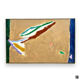
Kikuo Saito (JAPANESE / UNITED STATES / NEW YORK, 1939 - 2016) large oil painting on canvas havingJoshua Kodner4.2(386)See Sold PriceMar 09, 2024


![Northern provinces of the United States. THOMSON. District of Main[e] 1817 map (1 of 1)](https://p1.liveauctioneers.com/5584/299315/159320260_1_x.jpg?height=282&quality=70&version=1692738247)


![[ARCTIC]. BOWEN, Emanuel. A New & Accurate Map of the North... (1 of 1)](https://p1.liveauctioneers.com/928/318880/171360917_1_x.jpg?height=282&quality=70&version=1707501302)
![[BUSINESS]. Travel Guide of Negro Hotels and Guest Houses. Published by Afro-American Newspapers of (1 of 4)](https://p1.liveauctioneers.com/197/319238/171467937_1_x.jpg?height=282&quality=70&version=1707520367)