Sold-. large mixed group of maps, plans, and topograp-. large mixed group of maps, plans, and topographical views (A)including maps of Europe, Asia Minor, and with plans of Venice and Rome, an elevation of the facade of the Orangery at VersaillSee Sold Price
SoldSDUK. A large mixed group of mapsSDUK. A large mixed group of mapsregional and country maps including Russia, several of Italy and elsewhere, engraved maps, hand-coloured outlines, 390 x 310mm., [1845]; with 8 other maps of ISee Sold Price
SoldMiscellany.- - A large mixed group of maps,numerous schools and other atlas sheets, also some separate and folding maps, including a large World Map on Mercator's Projection, by Berghaus and Stülpnagel, North America by J. Harriosn after D'See Sold Price
SoldFWOR A large mixed group of maps of various countrFWOR A large mixed group of maps of various countries around the worldincluding the countries around of the Caribbean, Yugoslavia, U.S.A., Spain, France, Italy, Canada, the Lebanon, Norway andSee Sold Price
SoldBENG A large mixed group of maps of the U.K.BENG A large mixed group of maps of the U.K.including editions of Bartholomew's Half-Inch to Mile Map of England & Wales, with editions of Ordnance Survey New Popular Edition One-Inch MapsSee Sold Price
SoldItaly.- a mixed group of mapsa large, mixed, group of maps, national and regional, mostly Italy and surrounding Islands, by De L'Ilse, Homann, Sanson, Johnston, SDUK, etc., engraved and lithographed maps, many coloured,See Sold Price
SoldFaden (William) France Divided into ProvincesFaden (William) France Divided into Provinces,engraved map with hand-colouring, 540 x 640mm., central vertical fold, minor surface dirt, 1790; with a large mixed group of maps of France, incluSee Sold Price
SoldA mixed group of maps of the British IslesA large mixed group of maps of the British Isles, including several county maps, small road maps (10), and others of England, Wales, Scotland and Ireland, engravings and lithographs, severalSee Sold Price
SoldGreek Islands.- a mixed group of maps and plansGreek Islands.- a mixed group of maps and plans,including Tobias Conrad Lotter's Graeciae Antiquae Designatio Nova ..., and with maps by or after Kauffer, Tardieu, d'Anville, and others, engraSee Sold Price
SoldMediterranean.- A mixed group of maps and plansMediterranean.- A mixed group of maps and plans,including 43 maps by Joseph Roux, from 'Plans et Rades de la Méditerraneé', and others by or after Tardieu, Bernard, Gouffier, and others, engraSee Sold Price
Solda mixed group of maps and plansa mixed group of maps and plans,including maps by or after Blome, Bowen, Arrowsmith, and others, mainly of the Middle East, particularly of the Levant, with a small section of plates relatingSee Sold Price
SoldEurope. a mixed group of maps and plansEurope. a mixed group of national and regional maps and plans,including A New Map of Muscovy, from the English edition Olearius's The Voyages & Travels of the Ambassador Sent by Frederick DukeSee Sold Price
SoldLow Countries.- A mixed group of maps and plans ofLow Countries.- A mixed group of maps and plans of Holland and Belgium,by or after Tardieu, Harrewyn, Kitchin, Archer and others, including SDUK and Tallis plans of Brussels, engraved and lithSee Sold Price
SoldA mixed group of maps and plans of London and envA mixed group of maps and plans of London and environs,City Wards, plans for reconstructing the City after the Great Fire, maps of 20 miles around London, some incomplete sections of larger sSee Sold Price
SoldLondon.- Mixed group London plansMixed group of maps and plans of London,including a small group of city ward plans from Stow's Survey,1755, several by Stockdale, including Stepney, Limehouse, Peckham, Hampstead, Greewich anSee Sold Price
SoldA mixed group of regional maps and plans of England andincluding a locally published cloth Map of the Country Eight Miles Round Malvern, by H. Lamb & Son; a locally published cloth 'weather-proof' edition of Bacon's map of the Isle of Wight, by W. CouldreSee Sold Price
SoldA small, mixed group of maps and town plans of EnBritish Isles.- A small, mixed group of maps and town plans of England and Scotland, including several of Kent and the Isle of Thannet, the Isle of White, road maps and town plans, including TSee Sold Price
SoldA small, mixed group of national maps and town plBritish Isles.- A small, mixed group of national maps and town plans, including plans of New York, Brussels, Liverpool, Odessa and others, mostly European, engraved and lithographic maps, someSee Sold Price
SoldHouse Of Commons. mixed plans of LondonHouse Of Commons. Publisher A mixed group of plans and maps of London, including several of Downing Street and the Foreign Office, several of the Embankment and sewer networks, several plans oSee Sold Price
SoldCambridgeshire.- a mixed group of county mapsCambridgeshire.- a mixed group of small county maps,some with inset plans or vignette views and other ornamentation, by, for or after Blome, Cary, Moll, Morden, Moule, Ramble, Rocque, Seller,See Sold Price
SoldA mixed group of maps of North AmericaA mixed group of maps of North America,including a plan of New York, and parts of Canada, by Sidney Hall, Johnston, Day & Son, and others, engravings, lithographs, some printed in colour, v.sSee Sold Price
SoldCambridgeshire.- a mixed group of county maps-. a mixed group of small county maps,including a detailed plan of Bury St Edmunds, by Henshall after Dawson, and the Fens of the Bedford Levels, by R. Walker, some of the county maps with insSee Sold Price
SoldBotany.- - A large, mixed, group of mostly 19th andincluding c.55 plates for Curtis's Botanical Magazine, c.65 plates for Dietrich's Flora Universalis, c.55 for Andrews's Botanist's Repository, 26 plates for Van Houtte, 8 camellias by Berlèse and JSee Sold Price
SoldA large mixed group of Travel and Natural HistoryA large mixed group of Travel and Natural History prints,including facsimile Speed maps, tinted lithographs after David Roberts, engravings by M. Pool from Naauwkeurige Beschryuing van De KaaSee Sold Price
Post Medieval and Later Bronze and Other Large Artefact GroupTimeLine Auctions Ltd.4.6(183)See Sold PriceMar 08, 2024
Ancient Roman Imperial Coins - Mixed Large AE Roman Coin Group [10]TimeLine Auctions Ltd.4.6(183)See Sold PriceMar 09, 2024
Assortment of Railroad Paper - Rule Books, Stationary, Ink Blotter, Map, Timetables, and MoreRail & Road Auctions4.6(165)See Sold PriceMar 07, 2024
Group of Ten Railroad Photographs, Maps, and Prints - New Jersey, Long Island, and New YorkRail & Road Auctions4.6(165)See Sold PriceMar 07, 2024
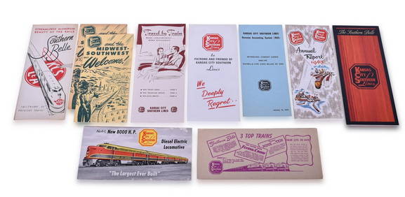
Ten Kansas City Southern Lines Advertising Brochures, Booklets, Annual Report, and WaybillRail & Road Auctions4.6(165)See Sold PriceMar 08, 2024
6" x 6" Framed Male Orange-Barred Sulphur Butterfly - Phoebis PhileaWeatherham Estate Treasures3.9(159)See Sold PriceMar 14, 2024
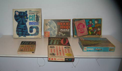
Large group of vintage games and puzzlesBaker's Antiques and Auctions3.2(471)See Sold PriceFeb 24, 2024
Emory's Notes of a Military Reconnoissance larger issuePBA Galleries4.7(385)See Sold PriceMar 07, 2024
AFRICA. Pre 'Scramble for Africa'. BARTHOLOMEW 1876 old antique map plan chartJasper524.5(9.9k)See Sold PriceFeb 28, 2024
Carte d'Afrique. Africa Soudan Zanzibar. LAPIE 1831 old antique map plan chartJasper524.5(9.9k)See Sold PriceFeb 28, 2024
AFRICA. Africa. Britannica 9th edition 1898 old antique vintage map plan chartJasper524.5(9.9k)See Sold PriceFeb 28, 2024
AFRICA. French North Africa and Morocco 1907 old antique map plan chartJasper524.5(9.9k)See Sold PriceFeb 28, 2024
Large Group of Mixed Dates UK and Territories Coinage Australia New Zealand Hong KongGCB Estate Sales4.5(86)See Sold PriceMar 02, 2024
Large group of vintage games and puzzlesBaker's Antiques and Auctions3.2(471)See Sold PriceMar 03, 2024


![Ancient Roman Imperial Coins - Mixed Large AE Roman Coin Group [10] (1 of 1)](https://p1.liveauctioneers.com/1191/317894/170617349_1_x.jpg?height=282&quality=70&version=1706620797)