ATLAS of ANTIENT GEOGRAPHY by SAMUEL BUTLER 1843John McInnis Auctioneers,LLC4.6(502)See Sold PriceFeb 24, 2024
18TH C. ANTIQUE MAP: FRENCH & INDIAN WAR, FRAMEDThomaston Place Auction Galleries4.4(386)See Sold PriceFeb 24, 2024
Rand McNally Railroad Map Cabinet w/ 21 Railroad MapsRail & Road Auctions4.6(165)See Sold PriceMar 08, 2024
Keith Haring - Ink on New York Map, Best Buddies, Inscribed, Signed, and DatedSapphire Auction Gallery4(67)See Sold PriceMar 02, 2024
LATE 17TH C. FRENCH MAP OF THE NEW WORLD BY ALEXIS-HUBERT JAILLOT (1632-1712)Thomaston Place Auction Galleries4.4(386)See Sold PriceFeb 24, 2024
Central Railroad of New Jersey Map of Sandy Hook Route-ca. 1903JM Hobby Supply and Railroad Artifact Auctions4.4(126)See Sold PriceFeb 24, 2024
Lot of Six Mixed Atlas Box Cars-HO Scale-New in BoxJM Hobby Supply and Railroad Artifact Auctions4.4(126)See Sold PriceFeb 25, 2024
Rand McNally/Santa Fe Railroad Map of Iowa-1912JM Hobby Supply and Railroad Artifact Auctions4.4(126)See Sold PriceFeb 24, 2024
NICOLAES VISSCHER (NETHERLANDS, 1618-1709) MAP OF THE NEW WORLDThomaston Place Auction Galleries4.4(386)See Sold PriceFeb 24, 2024
17TH C. WORLD MAP BY NICOLAES VISSCHER (NETHERLANDS, 1618-1709)Thomaston Place Auction Galleries4.4(386)See Sold PriceFeb 24, 2024
Lot of Six Mixed Atlas Cabooses-HO Scale-New in BoxJM Hobby Supply and Railroad Artifact Auctions4.4(126)See Sold PriceFeb 25, 2024
Early Map South AmericaEarly Map of South America Maker: Samuel Walker - Boston Dated: Circa 1830's - 40's Type: Engraving Dimensions: 11 x 8 1/2" Condition RepSee Sold Price
Early Map South AmericaEarly Map of South America Maker: Samuel Walker - Boston Dated: Circa 1830's - 40's Type: Engraving Demensions: 11 x 8 1/2" CSee Sold Price
Early Map South AmericaEarly Map of South America Cartographer: Samuel Walker - Boston Dated: Circa 1830's - 40's Type: Engraving Dimensions: 11 x 8 1/2" ConditSee Sold Price
Early Map South AmericaEarly Map of South America Cartographer: Samuel Walker - Boston Dated: Circa 1830's - 40's Type: Engraving Dimensions: 11 x 8 1/2" CoSee Sold Price
Early Map South AmericaEarly Map of South America Maker: Samuel Walker - Boston Dated: Circa 1830's - 40's Type: Engraving Demensions: 11 x 8 1/2" CSee Sold Price
Early Map South AmericaEarly Map of South America Cartographer: Samuel Walker - Boston Dated: Circa 1830's - 40's Type: Engraving Dimensions: 11 x 8 1/2" ConditSee Sold Price
EARLY MAP OF SOUTH AMERICA BY ROBERT DE VAUGONDYEarly copper-plate engraved, hand-outlined map, 21' x 28', a depiction of South America by French cartographer Didier Robert de Vaugondy, printed in 1750. The map is titled 'Amerique Meridionale' ('SoSee Sold Price
SoldEARLY MAP OF SOUTH AMERICA BY GUILLAUME DEL'ISLEEarly copper-engraved and hand colored map of South America, 25 1/2" x 20 3/4", published by noted French cartographer Guillaume Del'Isle, circa 1710. The map depicts the entirety of the continent asSee Sold Price
Early Map of South America 1829Map of South America Hand Colored Map. Cartographer: E. Huntington Publisher D. F. Robinson Dated: 1829 Dimensions: 11 x 8" ConditSee Sold Price
Sold17th C. Hand-Colored Map of Tabula MagellanicaA 17th C. hand-colored engraved map of Tabula Magellanica, by William Blaeu. An important early map of South America showing the Strait of Magellan. Framed under glass. Mat opening: 16-1/4in x 21-1/2iSee Sold Price
Sold1919 Map of South AmericaThis Early Map of South America is made by Denoyer Gepperep Co Chicago in 1919. It features beautiful bright colors, measuring 58 inches tall and 45 inches wide. It has some wear on the bottom as pictSee Sold Price
SoldAN EARLY CONTINENTAL MAP OF SOUTH AMERICA depicting theAN EARLY CONTINENTAL MAP OF SOUTH AMERICA depicting the voyages of Johann Van Stadden & Jean de Lery. Image 53 cm x 43 cm.See Sold Price
SoldEarly engraved map of South America by Thos. BowenEarly engraved map of South America by Thos. Bowen published by Royal Authority. 13.5"x18.5"See Sold Price
(2) EARLY FRENCH MAPS OF SOUTH AMERICA"Carte Generale de Colombie, de la Guyane Francaise, Hollandaise et Anglaise", 1826, by Adrien Hubert Brue, (1786-1832). From 1830 "Atlas de choix ou Recueil de cartes de geographie ancienne et modernSee Sold Price
(2) EARLY FRENCH MAPS OF SOUTH AMERICA"Carte Generale de Colombie, de la Guyane Francaise, Hollandaise et Anglaise", 1826, by Adrien Hubert Brue, (1786-1832). From 1830 "Atlas de choix ou Recueil de cartes de geographie ancienne et modernSee Sold Price
Sold(2) EARLY FRENCH MAPS OF SOUTH AMERICA"Carte Generale de Colombie, de la Guyane Francaise, Hollandaise et Anglaise", 1826, by Adrien Hubert Brue, (1786-1832). From 1830 "Atlas de choix ou Recueil de cartes de geographie ancienne et modernSee Sold Price
(2) EARLY FRENCH MAPS OF SOUTH AMERICA"Carte Generale de Colombie, de la Guyane Francaise, Hollandaise et Anglaise", 1826, by Adrien Hubert Brue, (1786-1832). From 1830 "Atlas de choix ou Recueil de cartes de geographie ancienne et modernSee Sold Price
SoldEarly map of North and South America(lot of 2) unframed 1838 engraved color Gaultier map of North and South America with the Eastern United States highlighted, 17'' x 12'', together with an unframed 1868 color map of the Western UnitedSee Sold Price
SoldMunster (Sebastian) Tabula novarum insularum, quasMunster (Sebastian) Tabula novarum insularum, quas diversis respectibus Occidentales & Indianas vocant,very early map of North and South America for the Cosmography, naming the Pacific Ocean,See Sold Price
Sold18th C Map of South AmericaEarly 18th century map of South America, hand colored outline, Carte de LAmerique Meridionale Dressee Survant les Nouvelles Observations de Mrs. De lAcademie Royale des Sciences. Laid down on paper, mSee Sold Price
SoldTWO EARLY MAPS. Includes "An Accurate Map of SoutTWO EARLY MAPS. Includes "An Accurate Map of South America", Emanuel Bowen, 18th century, engraving on laid paper, handcolored, matted and framed, 15"h. 16 1/4"w.; and a map of the military districtsSee Sold Price
SoldAmerica, Rare Early Map of the Americas"America", Rare Early Map of the Americas by Jodocus Hondius (Flemish/Dutch, 1563-1612) for a French edition of Mercator's Atlas, North and South America, hand-colored copper engraved map, published ASee Sold Price
Sold2 early maps, Chili & Auriacus Princip, by Ortelius.2 Antique Hand-Colored Map Prints, "Royaume de Chili", a miniature map of Chili, South America ; and "Auriacus Principatus" ( by Ortelius), showing the region around the Roman city of Orange in southeSee Sold Price
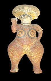
Large Human Effigy Pottery Vessel, Nicely Painted, Pre Columbian Pottery Vessle, South America. 14"Heartland Artifact Auctions Inc4.7(780)See Sold PriceFeb 25, 2024
Carey, pub. 1796 - A Chart of the West IndiesTrillium Antique Prints & Rare Books4.5(30)See Sold PriceFeb 24, 2024
Carey, pub. 1796 - Map of the State of MarylandTrillium Antique Prints & Rare Books4.5(30)See Sold PriceFeb 24, 2024
Carey, pub. 1796 - Map of GeorgiaTrillium Antique Prints & Rare Books4.5(30)See Sold PriceFeb 24, 2024
Carey, pub. 1796 - Map of The State of South CarolinaTrillium Antique Prints & Rare Books4.5(30)See Sold PriceFeb 24, 2024
Carey, pub. 1796 - Map of KentuckyTrillium Antique Prints & Rare Books4.5(30)See Sold PriceFeb 24, 2024
Carey, pub. 1796 - Map of the Tennassee State formerly part of North Carolina (Tennessee)Trillium Antique Prints & Rare Books4.5(30)See Sold PriceFeb 24, 2024
Map: A 19thC engraved and hand coloured map of South America. Published by the Society for theClaydon Auctioneers Ltd4.3(125)See Sold PriceFeb 26, 2024
Map: An 18thC engraved and hand coloured map of North America and South America, titled DeClaydon Auctioneers Ltd4.3(125)See Sold PriceFeb 26, 2024
1822 MAP of SOUTH AMERICA GEOGRAPHICAL STATISTICAL HISTORICAL antique 17.5x 22"Jasper524.5(9.8k)See Sold PriceFeb 27, 2024
1822 MAP of NORTH & SOUTH AMERICA GEOGRAPHICAL STATISTICAL HISTORICAL antiqueJasper524.5(9.8k)See Sold PriceFeb 27, 2024
Early Pre-Colombian Obsidian Knife, found in South AmericaHeartland Artifact Auctions Inc4.7(780)See Sold PriceMar 10, 2024
SOUTH CENTRAL AFRICA. Shows Zambesi river as circular! WELLER 1863 old mapJasper524.5(9.8k)See Sold PriceFeb 28, 2024