ATLAS of ANTIENT GEOGRAPHY by SAMUEL BUTLER 1843John McInnis Auctioneers,LLC4.5(505)See Sold PriceFeb 24, 2024
18TH C. ANTIQUE MAP: FRENCH & INDIAN WAR, FRAMEDThomaston Place Auction Galleries4.4(394)See Sold PriceFeb 24, 2024
Rand McNally Railroad Map Cabinet w/ 21 Railroad MapsRail & Road Auctions4.6(165)See Sold PriceMar 08, 2024
Keith Haring - Ink on New York Map, Best Buddies, Inscribed, Signed, and DatedSapphire Auction Gallery4.1(67)See Sold PriceMar 02, 2024
LATE 17TH C. FRENCH MAP OF THE NEW WORLD BY ALEXIS-HUBERT JAILLOT (1632-1712)Thomaston Place Auction Galleries4.4(394)See Sold PriceFeb 24, 2024
Central Railroad of New Jersey Map of Sandy Hook Route-ca. 1903JM Hobby Supply and Railroad Artifact Auctions4.4(127)See Sold PriceFeb 24, 2024
Lot of Six Mixed Atlas Box Cars-HO Scale-New in BoxJM Hobby Supply and Railroad Artifact Auctions4.4(127)See Sold PriceFeb 25, 2024
Rand McNally/Santa Fe Railroad Map of Iowa-1912JM Hobby Supply and Railroad Artifact Auctions4.4(127)See Sold PriceFeb 24, 2024
NICOLAES VISSCHER (NETHERLANDS, 1618-1709) MAP OF THE NEW WORLDThomaston Place Auction Galleries4.4(394)See Sold PriceFeb 24, 2024
17TH C. WORLD MAP BY NICOLAES VISSCHER (NETHERLANDS, 1618-1709)Thomaston Place Auction Galleries4.4(394)See Sold PriceFeb 24, 2024
Lot of Six Mixed Atlas Cabooses-HO Scale-New in BoxJM Hobby Supply and Railroad Artifact Auctions4.4(127)See Sold PriceFeb 25, 2024
Sold18 Map reference books: lot #1: Primarily SoutheasternBook 1: Southeast in Early Maps. 1973 (no dust jacket). Author: Cumming. Book 2: Degrees of Latitude. Author: Pritchard. Book 3: Virginia in Maps. Author: Stephenson. Book 4: Mapping of the American SSee Sold Price
SoldCollection of Four (4) Books on CartographyIncludes "Fine Antique Maps and Atlases; Catalogue 44", "Fine Antique Maps and Atlases: Catalogue 35", "Miniature Antique Maps", and "The Mapping of America"; condition of all ranges from Fair to VerySee Sold Price
SoldJohn Charles Fremont Expeditions, 4 Books + MapsBooks and Maps: "The Expeditions of John Charles Fremont". Comprises three volumes in four hardcover books, plus the map portfolio in slipcase. Volume 1, (published 1971) Travels from 1838-1844, VolumSee Sold Price
Sold4 books on maps[Reference]. 4 Titles. 8vo/4to, hardcover (3 in dj). Near Fine. ++ Simon Winchester. The Map That Changed The World: William Smith and the Birth of Modern Geography. (2001). 1st ed. ++ Martha HopkinsSee Sold Price
SoldAntique Buffier Map Atlas of the World, 1761Title/Content of Map: 1761 Buffier Map Atlas of the World -- Geographie Universelle Date Printed: 1761 Venice Cartographer: C. Buffier Size: 6.4 x 4 in. book; maps mostly pullout with folds This handsSee Sold Price
1761 Buffier Map Atlas of the World1761 Buffier Map Atlas of the World -- Geographie Universelle. C. Buffier, 1761 Venice, 6.4 X 4 In. Book; Maps Mostly Pullout With Folds. This Rare Atlas Issued at Both Venice and Lyon Over Time. it HSee Sold Price
Sold4 Railroad Books and MapsDESCRIPTION: Four Railroad Books and Maps. Includes: 1) Rules for The Government of the Following Sub-Divisions of the Transportation Department of the Western Maryland Railroad Company: Train and TelSee Sold Price
Sold[Maps & Mapping]. 4 Titles. Hardcover in dj but l[Maps & Mapping]. 4 Titles. Hardcover in dj but last. Very good or noted. ++ Reps, John W. Tidewater Towns: City Planning In Colonial Virginia And Maryland. Colonial Wmsburg/UVA Press, (1972). OblongSee Sold Price
4 large book plate maps4 large book plate maps including c. 1862 Johnson's Roman Empire; City Map of Beloit 1871; Township map of the state of Wisconsin by Everts Baskin & Stewart;City map of Janesville by Everts Baskin & SSee Sold Price
4 large book plate maps4 large book plate maps including c. 1862 Johnson's Roman Empire; City Map of Beloit 1871; Township map of the state of Wisconsin by Everts Baskin & Stewart;City map of Janesville by Everts Baskin & SSee Sold Price
SoldLot of 4 Engineer's BooksLot of 4 Engineer's Books. Project Maps River and Harbor Works Fox River Wisconsin 1957. 2 - Navigation Charts Middle and Upper Mississippi River Cairo IL to Minneapolis MN 1959. 3 - Charts of the IllSee Sold Price
DECORATIVE COPY 17TH CENTURY MAP OF VENICEDECORATIVE COPY 17TH CENTURY MAP OF VENICE: Decorative late 19th / early 20th century reproduction of 17th century map of Venice, 4 pages from book. Map pre dates 1682 as the dome at the Church of SaiSee Sold Price
Sold4 Books incl: Goss. THE MAPPING OF NORTH AMERICA.[Reference] 4 Titles. 8vo-folio. Hardcover (3 in dj). ++ Schwartz and Ehrenberg. THE MAPPING OF AMERICA. Abrams, (1980). Near fine in very good dj. ++ John Goss. THE MAPPING OF NORTH AMERICA. WellfleeSee Sold Price
SoldGrp 4 Facsimile Map BooksGroup of four facsimile map books, includes "Spieghel Der Zeervaerdt;" Ortelius "Theatrum Orbis Terrarum;" "The History of Abraham Ortelius and his Theatrum Orbis Terrarum;" and "The History of LucasSee Sold Price
10 Vols (6 Books & 4 Magazines)-- Map reference.[Reference]. 8 Titles (10 Vols, including 6 books & 4 magazine issues). Vp:vp. 4to. 6 hardcover (4 in dj, 1 with dj fragments), 4 magazines softcover. Fair to near fine (usually closer to the latter).See Sold Price
Sold4 Items: 2 Vols Sanborn + Mitchell's + DC map.[Washington, D.C./School Atlas]. 4 Items (3 Books + 1 Map). ++ Cherrydale, Arlington County, Virginia. Sanborn Map Company, 1929. Orig wraps; good, labels removed from top edge of front wrap, cornersSee Sold Price
Sold~146 issues: Mercator's World, Map Collector...[Map & Book Collecting]. 4 Magazines (approx. 146 Issues). 4to. Wraps. Very good and better. ++ Mercator's World: The Magazine of Maps, Exploration, and Discovery. About 99 bimonthly issues. (Astor PuSee Sold Price
Sold1887 Baldwin's Orange Directory Pocket Map of the CityBook 4"x6" Map 28"x21", Copyright 1885See Sold Price
MARTINET / DE VRIES Catechism of Nature 4 Vol. Set c1788 Engravings Rare!Luis Porretta Fine Arts4.3(10)See Sold PriceMar 02, 2024
MAP - PIETER SCHENK / VALK / JANSSEN Hand Colored superb Map Central Italy c1702Luis Porretta Fine Arts4.3(10)See Sold PriceMar 02, 2024
General Books - Four Maps of Great Britain Designed by Matthew Paris About A.D. 1250TimeLine Auctions Ltd.4.6(184)See Sold PriceMar 08, 2024
Arrowsmith & Lewis - Map of PolynesiaTrillium Antique Prints & Rare Books4.5(33)See Sold PriceFeb 24, 2024
Arrowsmith & Lewis - Map of North AmericaTrillium Antique Prints & Rare Books4.5(33)See Sold PriceFeb 24, 2024
Arrowsmith & Lewis - Map of the World on Mercator's ProjectionTrillium Antique Prints & Rare Books4.5(33)See Sold PriceFeb 24, 2024
Arrowsmith & Lewis - Map of LouisianaTrillium Antique Prints & Rare Books4.5(33)See Sold PriceFeb 24, 2024
Arrowsmith & Lewis - Map of the United StatesTrillium Antique Prints & Rare Books4.5(33)See Sold PriceFeb 24, 2024
De Jode, Rare, pub. 1593 - Map of Africa (Africae Vera Forma, et Situs)Trillium Antique Prints & Rare Books4.5(33)See Sold PriceFeb 24, 2024
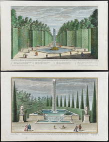
Demortain - 4 Fountain & Garden EngravingsTrillium Antique Prints & Rare Books4.5(33)See Sold PriceFeb 24, 2024
Brookshaw - 6 Cherry LithographsTrillium Antique Prints & Rare Books4.5(33)See Sold PriceFeb 24, 2024
Linnaeus - Pair: Bengal & Golden OriolesTrillium Antique Prints & Rare Books4.5(33)See Sold PriceFeb 24, 2024
Linnaeus - Passerina or Little OwlTrillium Antique Prints & Rare Books4.5(33)See Sold PriceFeb 24, 2024
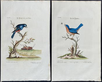
Edwards & Seligmann - 4 Bird EngravingsTrillium Antique Prints & Rare Books4.5(33)See Sold PriceFeb 24, 2024
Audubon, Imperial Folio - 4 Lithographs of Squirrel, Rat, MiceTrillium Antique Prints & Rare Books4.5(33)See Sold PriceFeb 24, 2024
1906 Mendenhalls Northern Ohio Road Guide Map BookCheck the Oil Promotions, LLC4.6(346)See Sold PriceMar 10, 2024


![[Maps & Mapping]. 4 Titles. Hardcover in dj but l (1 of 0)](https://p1.liveauctioneers.com/dist/images/placeholder.jpg?height=282&quality=70)