ATLAS of ANTIENT GEOGRAPHY by SAMUEL BUTLER 1843John McInnis Auctioneers,LLC4.5(505)See Sold PriceFeb 24, 2024
18TH C. ANTIQUE MAP: FRENCH & INDIAN WAR, FRAMEDThomaston Place Auction Galleries4.4(393)See Sold PriceFeb 24, 2024
Rand McNally Railroad Map Cabinet w/ 21 Railroad MapsRail & Road Auctions4.6(165)See Sold PriceMar 08, 2024
Keith Haring - Ink on New York Map, Best Buddies, Inscribed, Signed, and DatedSapphire Auction Gallery4(67)See Sold PriceMar 02, 2024
LATE 17TH C. FRENCH MAP OF THE NEW WORLD BY ALEXIS-HUBERT JAILLOT (1632-1712)Thomaston Place Auction Galleries4.4(393)See Sold PriceFeb 24, 2024
Central Railroad of New Jersey Map of Sandy Hook Route-ca. 1903JM Hobby Supply and Railroad Artifact Auctions4.4(127)See Sold PriceFeb 24, 2024
Lot of Six Mixed Atlas Box Cars-HO Scale-New in BoxJM Hobby Supply and Railroad Artifact Auctions4.4(127)See Sold PriceFeb 25, 2024
Rand McNally/Santa Fe Railroad Map of Iowa-1912JM Hobby Supply and Railroad Artifact Auctions4.4(127)See Sold PriceFeb 24, 2024
NICOLAES VISSCHER (NETHERLANDS, 1618-1709) MAP OF THE NEW WORLDThomaston Place Auction Galleries4.4(393)See Sold PriceFeb 24, 2024
17TH C. WORLD MAP BY NICOLAES VISSCHER (NETHERLANDS, 1618-1709)Thomaston Place Auction Galleries4.4(393)See Sold PriceFeb 24, 2024
Lot of Six Mixed Atlas Cabooses-HO Scale-New in BoxJM Hobby Supply and Railroad Artifact Auctions4.4(127)See Sold PriceFeb 25, 2024
SoldDapper's account of Asia with plates & maps, 1681Heading: Author: Dapper, Olfert Title: Umbsta?ndliche und eigentliche beschreibung von Asia:in sich haltend die landschafften Mesopotamien, Babylonien, Assyrien, Anatolien oder Klein-Asien... Place PSee Sold Price
SoldDapper (Olfert) AsiaDapper (Olfert) Asia,2 parts in 1 vol., first edition, additional engraved title, first title printed in red and black, 4 double-page engraved maps, 28 plates, some double-page, half-page textSee Sold Price
Sold(ISRAEL, LAND OF)DAPPER, O[LFERT]. Asia; oder Genaue und Gründliche Beschreibung des Gantzen Syrien und Palestins. Two volumes in one. Additional engraved title. 39 copper-engraved plates and maps, many folding or doSee Sold Price
SoldDapper (Olfert) Asia, oder Genaue und Grundliche BDapper (Olfert) Asia, oder Genaue und Grundliche Beschreibung des ganzen Syrien und Palestins,additional engraved title, printed title in red and black, 39 engraved maps, plans and plates, mosSee Sold Price
SoldMiddleton. A NEW AND COMPLETE SYSTEM OF GEOGRAPHY.[Travel/Plates/Maps]. Charles Theodore Middleton, et. al. A NEW AND COMPLETE SYSTEM OF GEOGRAPHY. Containing a full, accurate, authentic, and interesting Account and Description of Europe, Asia, AfricSee Sold Price
Middleton's Geography c.1780 with Maps & PlatesTitle: A New and Complete System of Geography. Containing a Full, Accurate, Authentic, and Interesting Account and Description of Europe, Asia, Africa and America... Author: Middleton, Charles TheodorSee Sold Price
SoldDapper (Olfert) AsiaDapper (Olfert) Asia, additional engraved title, printed title in red and black, 10 double-page engraved maps and plans, 29 engraved plates (of which 21 are double-page or folding), 2 plates wSee Sold Price
SoldAsia.- Fryer (John) A New Account of East-India andAsia.- Fryer (John) A New Account of East-India and Persia, first edition, lacking half-title with portrait on verso, with title printed in red and black, 2 engraved maps only (of 7 maps/plates) and oSee Sold Price
South East Asia.- Symes (Michael) An Account of anSouth East Asia.- Symes (Michael) An Account of an Embassy to the Kingdom of Ava, sent by the Governor-General of India,plate vol. only, 2 folding engraved maps and 26 plates, some folding, 3See Sold Price
SoldCoxe (W.) Account of the Russian DiscoveriesCoxe (William) Account of the Russian Discoveries between Asia and America, third edition, 5 folding engraved maps and plates, occasional foxing and offsetting, contemporary calf, slightly rubSee Sold Price
SoldCoxe Account of the Russian DiscoveriesCoxe (William) Account of the Russian Discoveries between Asia and America, fourth edition, engraved frontispiece map, 4 other maps and charts and 1 plate, offsetting, contemporary half straigSee Sold Price
Sold2 Books incl: ACCOUNT OF THE RUSSIAN... 18032 Titles. ++ William Coxe. ACCOUNT OF THE RUSSIAN DISCOVERIES BETWEEN ASIA AND AMERICA. Lon: Cadell and Davies, 1803. Sabin 17309. 6 plates (4 folding) of which 5 are maps. Maps bound between page xxiSee Sold Price
SoldAsia.- [Butler - ] A Sketch of Assam: with some Account( Major John)] A Sketch of Assam: with some Account of the Hill Tribes, first edition, 16 hand-coloured lithographed plates, 1 uncoloured wood-engraving, illustrations, lacks folding map, very occasioSee Sold Price
SoldAccount of Arabia with plates & maps, 1773Heading: Author: Niebuhr, Carsten Title: Description de l'Arabie, faite sur des observations propres et des avis recueillis dans les lieux mêmes Place Published: Amsterdam / Utrecht Publisher:S. J.See Sold Price
Ritter Accounts Mission Asia 12 vol. maps ChinaRitter, Joseph Ignaz (Hrsg.). Jahrbücher der Gesellschaft zur Verbreitung des Glaubens in beiden Welten. Aus dem Französischen übersetzt von Mehren und zum Besten der Missionen herausgegeben. 12 BdSee Sold Price
Sold1842 Map of AsiaAuthor: Scott Title: 1842 Map of Asia Medium: Ink on Paper Dimensions: 11.5"X 9" Description: Map of Asia dated 1842. Copper plate map. Engraved by R. Scott. Published by Thomas Nelson in Edinburgh. PSee Sold Price
Marvin (Charles) Reconnoitring Central AsiaMarvin (Charles) Reconnoitring Central Asia,second edition, plates, folding map, advertisements at end, title and dedication foxed, bookplate on front pastedown, ink stamp on fly-leaf, hingesSee Sold Price
Soldc. 1744 ASIA Hand-Colored Map, Matthaeus SeutterHistoric Maps c. 1744 Hand-Colored Map of Asia by Matthaeus Seutter c. 1744, Hand-Colored Engraved Copper-Plate Map titled, “ASIA Cum omnibus Imperiis Provinciis Statibus et Insulis Correcta et adorSee Sold Price
Athanasius Kircher (German, 1601-1680) MapAthanasius Kircher (German, 1601-1680), "Tabula Geographica Hydrophylacium Asia Majoris...", copper-plate engraved map, from Mundi Subterranei, c. 1665, Amsterdam, featuring decorative cartouche and tSee Sold Price
SoldVincent Land of the White Elephant,Vincent (Frank) The Land of the White Elephant, Sights and Scenes in Sout-Eastern Asia,frontispiece, folding map, plates, contemporary half calf, upper cover detached, rubbed, 1873 § Burma GazSee Sold Price
SoldSkrine (C.P.) Chinese Central AsiaSkrine (C.P.) Chinese Central Asia, first American edition, plates, folding map, small owner's ink stamp on front endpaper and frontispiece, original cloth, gilt spine lettering slightly dulleSee Sold Price
Soldc. 1798, Copper Engraved Map - ASIAHistoric Maps c. 1798, Engraved Map of ASIA c. 1798, Copper Plate Engraved Map of, ASIA FROM THE LATEST AUTHORITIES, Choice Very Fine. Copper Plate Engraved Map, uncolored, measuring 7.5” x 8.75”See Sold Price
SoldFrench Copper Plate Hand-Colored Map of AsiaAn antique copper plate hand-colored map of Asia. Unframed, 26 1/2" H x 37" W, excellent condition.See Sold Price
Sold12V James Bell A SYSTEM OF GEOGRAPHY 1839‐12V James Bell A SYSTEM OF GEOGRAPHY 1839‐1840 Complete Set Antique Engraved Folding Maps Plates Illustrated History Europe Asia South America Asia Minor Islands Australia North America CartSee Sold Price
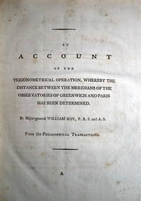
WILLIAM ROY Rare Navigation Book c1797 Trigonometry Between Paris & GreenwichLuis Porretta Fine Arts4.3(10)See Sold PriceMar 02, 2024
Vintage County Map Of NY State Plate EngravingThe Benefit Shop Foundation Inc.4.3(2.9k)See Sold PriceFeb 28, 2024
Large lot of assorted prints. 18th-20th century. To include: North American and other maps, CivilTremont Auctions4.5(297)See Sold PriceFeb 25, 2024
[ARCTIC]. BOWEN, Emanuel. A New & Accurate Map of the North...Potter & Potter Auctions4.6(545)See Sold PriceMar 07, 2024
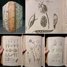
1797 Universal Magazine BOTANY PLATES Flowers FRUIT 12 Copper Engraved PlatesPrivate NY Collection4.2(22)See Sold PriceMar 01, 2024
Carey, pub. 1796 - A Chart of the West IndiesTrillium Antique Prints & Rare Books4.5(32)See Sold PriceFeb 24, 2024
Carey, pub. 1796 - Map of GeorgiaTrillium Antique Prints & Rare Books4.5(32)See Sold PriceFeb 24, 2024
Carey, pub. 1796 - Map of The State of South CarolinaTrillium Antique Prints & Rare Books4.5(32)See Sold PriceFeb 24, 2024
Carey, pub. 1796 - Map of KentuckyTrillium Antique Prints & Rare Books4.5(32)See Sold PriceFeb 24, 2024
Carey, pub. 1796 - Map of the Tennassee State formerly part of North Carolina (Tennessee)Trillium Antique Prints & Rare Books4.5(32)See Sold PriceFeb 24, 2024
Kent & Sussex.- Moss (W.G.) The History and Antiquities of the Town and Port of Hastings, 1824; andForum Auctions4.3(53)See Sold PriceFeb 29, 2024
Lot Of Mid Century Ephemera, Including Maps & 1957 License PlatesClark's Auction Company4.6(443)See Sold PriceMar 03, 2024
Buffon, Vaugody & Bell 1785 America - Map of the New ContinentAlbion Auctions4.6(341)See Sold PriceMar 01, 2024
Buffon, Vaugody & Bell 1785 Map of the Old Continent. Africa, AsiaAlbion Auctions4.6(341)See Sold PriceMar 01, 2024


![Asia.- [Butler - ] A Sketch of Assam: with some Account (1 of 1)](https://p1.liveauctioneers.com/410/87791/45003908_1_x.jpg?height=282&quality=70&version=1461161196)


![[ARCTIC]. BOWEN, Emanuel. A New & Accurate Map of the North... (1 of 1)](https://p1.liveauctioneers.com/928/318880/171360917_1_x.jpg?height=282&quality=70&version=1707501302)