ATLAS of ANTIENT GEOGRAPHY by SAMUEL BUTLER 1843John McInnis Auctioneers,LLC4.5(505)See Sold PriceFeb 24, 2024
18TH C. ANTIQUE MAP: FRENCH & INDIAN WAR, FRAMEDThomaston Place Auction Galleries4.4(393)See Sold PriceFeb 24, 2024
Rand McNally Railroad Map Cabinet w/ 21 Railroad MapsRail & Road Auctions4.6(165)See Sold PriceMar 08, 2024
Keith Haring - Ink on New York Map, Best Buddies, Inscribed, Signed, and DatedSapphire Auction Gallery4(67)See Sold PriceMar 02, 2024
LATE 17TH C. FRENCH MAP OF THE NEW WORLD BY ALEXIS-HUBERT JAILLOT (1632-1712)Thomaston Place Auction Galleries4.4(393)See Sold PriceFeb 24, 2024
Central Railroad of New Jersey Map of Sandy Hook Route-ca. 1903JM Hobby Supply and Railroad Artifact Auctions4.4(127)See Sold PriceFeb 24, 2024
Lot of Six Mixed Atlas Box Cars-HO Scale-New in BoxJM Hobby Supply and Railroad Artifact Auctions4.4(127)See Sold PriceFeb 25, 2024
Rand McNally/Santa Fe Railroad Map of Iowa-1912JM Hobby Supply and Railroad Artifact Auctions4.4(127)See Sold PriceFeb 24, 2024
NICOLAES VISSCHER (NETHERLANDS, 1618-1709) MAP OF THE NEW WORLDThomaston Place Auction Galleries4.4(393)See Sold PriceFeb 24, 2024
17TH C. WORLD MAP BY NICOLAES VISSCHER (NETHERLANDS, 1618-1709)Thomaston Place Auction Galleries4.4(393)See Sold PriceFeb 24, 2024
Lot of Six Mixed Atlas Cabooses-HO Scale-New in BoxJM Hobby Supply and Railroad Artifact Auctions4.4(127)See Sold PriceFeb 25, 2024
SoldTable Maps and Napkins - the Establishment of the StateLot of 4 table maps and napkins celebrating the establishment of the State of Israel/ independent days: *Cloth table map with the map of Israel - the Founding of the State "Israel Is Reborn". With theSee Sold Price
Special! Printed cloth napkin made in honor of theSpecial! Printed cloth napkin made in honor of the establishment of the State of Israel, 15.5.1948, a map of Israel according to the Partition Plan borders in its center, important dates - the BalfourSee Sold Price
SoldThe declaration of the establishment of the state - 21The Declaration of State Establishment - 21 Tables on the Declaration of Independence by David Tertkover. Modan, 1988. "When you say 'Jewish state', you define ownership and you define belongingSee Sold Price
Sold1868 ATLAS HERKIMER CO NY STRANAHAN BEACH NICHOLS.1868 ATLAS HERKIMER CO NY STRANAHAN BEACH NICHOLS. 32 PAGES OF HAND COLORED MAPS. INCL. TABLE OF DISTANCES, STATE MAP, ETC. PUBLISHED BY STRANAHAN, BEACH & NICHOLS, NY. A FEW PGS HAVE TAPED AREAS, SOMSee Sold Price
Gilman Table Map, 1848Map: Untitled "Tables Map" of the continental United States and western territories showing boundaries after the Treaty of Guadalupe Hidalgo Maker: E. Gilman Publishing: Washington 1848 Important andSee Sold Price
Sold1874 ATLAS OF ONTARIO CO. NY MAPS.1874 OF ATLAS ONTARIO CO. NY MAPS. 83 PGS HAND COLORED MAPS. INCLUDES STATE MAP, OUTLINE PLAN, DISTANCE TABLE, POST OFFICES, POPULATIONS, EXPLANATIONS. PUBLISHED BY POMEROY, WHITMAN & CO. PHILADELPHIASee Sold Price
Sold1874 OF ATLAS ONTARIO CO. NY MAPS.1874 OF ATLAS ONTARIO CO. NY MAPS. 83 PGS HAND COLORED MAPS. INCLUDES STATE MAP, OUTLINE PLAN, DISTANCE TABLE, POST OFFICES, POPULATIONS, EXPLANATIONS. PUBLISHED BY POMEROY, WHITMAN & CO. PHILADELPHIASee Sold Price
SoldBradford (Thomas Gamaliel) Comprehensive AtlasBradford (Thomas Gamaliel) Comprehensive Atlas,frontispiece and 10 further plates, charts and tables, and 66 maps, mostly North American states, also including 2 sheets of numerous town plans,See Sold Price
Survey of the Establishment of the United States atTitle/Content of Map: Survey of the Establishment of the United States at Mount Dearborn On The Catawba River in The State Of South Carolina. Date: 1860 Cartographer: MACOMB, ALEXANDER Size: 14.5X18.8See Sold Price
SoldSS UNITED STATES LINES Linen and Towels:SS UNITED STATES LINES Linen and Towels: Four Table Napkins, 3 Hand Towels and 2 Bath Towels, all United States Lines. (100-200)See Sold Price
SoldMid-Century Coffee Table, Map MotifMid-Century coffee table, map motif, acrylic top, straight stretchered legs, brass accents 18.5"h x 41"w x 28.5"d State-wide delivery is available for this item. Please email shipping@vogtauction.comSee Sold Price
FACSIMILE UNITED STATES OF AMERICA $100 BOND10 ¾" x 4". Facsimile United States of America $100 bond. Vignette of General Winfield Scott at top center. Verso bears advertisements for "H.H. Lloyd & Co's People's Map Establishment," purveyor ofSee Sold Price
FACSIMILE UNITED STATES OF AMERICA $100 BOND10 ¾" x 4". Facsimile United States of America $100 bond. Vignette of General Winfield Scott at top center. Verso bears advertisements for "H.H. Lloyd & Co's People's Map Establishment," purveyor ofSee Sold Price
FACSIMILE UNITED STATES OF AMERICA $100 BOND10 ¾" x 4". Facsimile United States of America $100 bond. Vignette of General Winfield Scott at top center. Verso bears advertisements for "H.H. Lloyd & Co's People's Map Establishment," purveyor ofSee Sold Price
Facsimile United States Of America $100 Bond10 ¾" x 4". Facsimile United States of America $100 bond. Vignette of General Winfield Scott at top center. Verso bears advertisements for "H.H. Lloyd & Co's People's Map Establishment," purveyor ofSee Sold Price
SoldWALL MAP OF THE STATE OF MAINE.Circa 1862, Portland, Maine. J. Chace, Jr. & Co. Publishers. U.S. Coast Survey Table by H.F. Walling. A large map showing the state of Maine. The towns and counties, maps of some small towns tipped inSee Sold Price
SoldUnited Nations Resolution regarding the EstablishmentUnited Nations Resolution regarding the Establishment of the State - with Maps - [Tel Aviv, 1948] Full version with three maps. Published by "Ha'Aretz". 31 pp. 15 cm. Condition: Excellent.See Sold Price
SoldBurgoyne, John. A State of the Expedition from CanadaBurgoyne, John. A State of the Expedition from Canada >>>>>>>>>>>> London: for J. Almon, 1780. 8vo. Compete with folding table, folding map, and 5 folding plans accented in color. Period speckled calfSee Sold Price
Sold6V COLLECTIBLE ANTIQUE NEW YORK STATE HISTORY6V COLLECTIBLE ANTIQUE NEW YORK STATE HISTORY Decorative Gilt Buffalo Scrapbook Octavius Orlando Cottle Leatherbound Onondaga County Centennial Syracuse Maps Tables Portraits Onondaga Reservation LakeSee Sold Price
Vintage CALIFORNIA State Map Souvenir TableclothThis cotton vintage 40's California souvenir tablecloth is in excellent condition, with a couple of very faint spots and no wear. It measures 48" X 52."The LARGE SIZE and WONDERFUL COLORS make this viSee Sold Price
EASTERN UNITED STATES. Railroads. Population table.TITLE/CONTENT OF MAP: 'United States of North America and part of Canada (Eastern Sheet)' DATE PRINTED: 1883 IMAGE SIZE: Approx 40.0 x 35.0cm, 15.75 x 13.75 inches (Large); Please note that this is aSee Sold Price
SoldGroup of vintage Burlington route time table schedules1920s-1960s, includes United States map from 1925 by Burlington RouteSee Sold Price
SoldNarrative of the United States Exploring ExpeditiAuthor: Wilkes, Charles Description: 5 volumes. lvi, 434; xi, 476;438 + [16] ads; xiii, 539; xii, 558 pp. Illustrated with numerous wood engravings in the text; 14 lithographed maps & tables, severalSee Sold Price
ALEXANDER BALD 1780 1st Edition Scotland Corn Dealer Agriculture AssistantLuis Porretta Fine Arts4.3(10)See Sold PriceMar 02, 2024
United States Map with American Flag 3-D Wall Mount PaintingWeatherham Estate Treasures3.9(159)See Sold PriceFeb 29, 2024
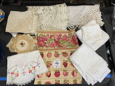
Lot 20+ Vintage & Contemporary Table LinensThe Benefit Shop Foundation Inc.4.3(2.9k)See Sold PriceFeb 28, 2024
Caravan Routes in Palestine Linen Map - Germany, 1881Levy Auction House4.3(11)See Sold PriceFeb 27, 2024
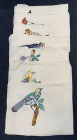
Set 8 Embroidered Linen Bird Cocktail NapkinsThe Benefit Shop Foundation Inc.4.3(2.9k)See Sold PriceFeb 28, 2024
KAFFE Fasset Millefiori, Sferra Linen Napkins, 12The Benefit Shop Foundation Inc.4.3(2.9k)See Sold PriceFeb 28, 2024
1887 Appletons' General Guide to the United State and Canada Part IIRail & Road Auctions4.6(165)See Sold PriceMar 08, 2024
1905 20th Century Atlas of Boone County IllinoisMatthew Bullock Auctioneers4.7(1.8k)See Sold PriceFeb 24, 2024
Set 7 Vtg Cotton Round Tablecloth and NapkinsThe Benefit Shop Foundation Inc.4.3(2.9k)See Sold PriceMar 13, 2024
Cooke, George 1801 Antique Map. United States of AmericaAlbion Auctions4.6(341)See Sold PriceMar 01, 2024
Blackie (Pub) 1882 Folio Map. United States of North AmericaAlbion Auctions4.6(341)See Sold PriceMar 01, 2024
[Spokane, Washington State] Maps, Pins & More (8)Grant Zahajko Auctions, LLC4.7(1k)See Sold PriceMar 06, 2024


![[Spokane, Washington State] Maps, Pins & More (8) (1 of 5)](https://p1.liveauctioneers.com/5755/320282/172114031_1_x.jpg?height=282&quality=70&version=1708463029)


