ATLAS of ANTIENT GEOGRAPHY by SAMUEL BUTLER 1843John McInnis Auctioneers,LLC4.6(502)See Sold PriceFeb 24, 2024
18TH C. ANTIQUE MAP: FRENCH & INDIAN WAR, FRAMEDThomaston Place Auction Galleries4.4(386)See Sold PriceFeb 24, 2024
Rand McNally Railroad Map Cabinet w/ 21 Railroad MapsRail & Road Auctions4.6(165)See Sold PriceMar 08, 2024
Keith Haring - Ink on New York Map, Best Buddies, Inscribed, Signed, and DatedSapphire Auction Gallery4(67)See Sold PriceMar 02, 2024
LATE 17TH C. FRENCH MAP OF THE NEW WORLD BY ALEXIS-HUBERT JAILLOT (1632-1712)Thomaston Place Auction Galleries4.4(386)See Sold PriceFeb 24, 2024
Central Railroad of New Jersey Map of Sandy Hook Route-ca. 1903JM Hobby Supply and Railroad Artifact Auctions4.4(126)See Sold PriceFeb 24, 2024
Lot of Six Mixed Atlas Box Cars-HO Scale-New in BoxJM Hobby Supply and Railroad Artifact Auctions4.4(126)See Sold PriceFeb 25, 2024
Rand McNally/Santa Fe Railroad Map of Iowa-1912JM Hobby Supply and Railroad Artifact Auctions4.4(126)See Sold PriceFeb 24, 2024
NICOLAES VISSCHER (NETHERLANDS, 1618-1709) MAP OF THE NEW WORLDThomaston Place Auction Galleries4.4(386)See Sold PriceFeb 24, 2024
17TH C. WORLD MAP BY NICOLAES VISSCHER (NETHERLANDS, 1618-1709)Thomaston Place Auction Galleries4.4(386)See Sold PriceFeb 24, 2024
Lot of Six Mixed Atlas Cabooses-HO Scale-New in BoxJM Hobby Supply and Railroad Artifact Auctions4.4(126)See Sold PriceFeb 25, 2024
Sold1898 Rand McNally Map of the United States -- UnitedTitle/Content of Map: 1898 Rand McNally Map of the United States -- United States Cartographer: Rand McNally Year/Place: 1898, Chicago Size: 9.2 X 12.4 in. This is a quite detailed political map of thSee Sold Price
Sold1898 Rand McNally Map of the United States -- UnitedTitle/Content of Map: 1898 Rand McNally Map of the United States -- United States Cartographer: Rand McNally Year/Place: 1898, Chicago Size: 9.2 X 12.4 in. This is a quite detailed political map of thSee Sold Price
1898 Rand McNally Map of the United States -- UnitedTitle: 1898 Rand McNally Map of the United States -- United States Cartographer: Rand McNally Year / Place: 1898, Chicago Map Dimension (in.): 9.2 X 12.4 in. This is a quite detailed political map ofSee Sold Price
1898 Rand McNally Map of the United States -- United StatesTitle: 1898 Rand McNally Map of the United States -- United States Cartographer: Rand McNally Year / Place: 1898, Chicago Map Dimension (in.): 9.2 X 12.4 in. This is a quite detailed political map ofSee Sold Price
1898 Rand McNally Map of the United States -- UnitedTitle/Content of Map: 1898 Rand McNally Map of the United States -- United States Cartographer: Rand McNally Year/Place: 1898, Chicago Size: 9.2 X 12.4 in. This is a quite detailed political map of thSee Sold Price
1898 Rand McNally Map of the United States -- UnitedTitle/Content of Map: 1898 Rand McNally Map of the United States -- United States Cartographer: Rand McNally Year/Place: 1898, Chicago Size: 9.2 X 12.4 in. This is a quite detailed political map of thSee Sold Price
1898 Rand McNally Map of the United States -- UnitedTitle: 1898 Rand McNally Map of the United States -- United States Cartographer: Rand McNally Year / Place: 1898, Chicago Map Dimension (in.): 9.2 X 12.4 in. This is a quite detailed political map ofSee Sold Price
1898 Rand McNally Map of the United States -- UnitedTitle: 1898 Rand McNally Map of the United States -- United States Cartographer: Rand McNally Year / Place: 1898, Chicago Map Dimension (in.): 9.2 X 12.4 in. This is a quite detailed political map ofSee Sold Price
1898 Rand McNally US Population Density Map -- RandTitle/Content of Map: 1898 Rand McNally US Population Density Map -- Rand McNally & Co.'s Map of the United states Showing in Six Degrees the Density of Population, 1890 Cartographer: Rand McNally YeaSee Sold Price
1898 Rand McNally US Population Density Map -- RandTitle: 1898 Rand McNally US Population Density Map -- Rand McNally & Co.'s Map of the United states Showing in Six Degrees the Density of Population, 1890 Cartographer: Rand McNally Year / Place: 1898See Sold Price
SoldVintage RAND MCNALLY Map of the United StatesVintage RAND MCNALLY Map of the United States, inscription to lower right reads ‘Rand McNally Standard Map of the United States’, subject a map of the US, measures 28 1/4 x 39 7/8 inches, wooden fSee Sold Price
Rand McNally: Antique Railroad Map of United StatesTitle/Content of Map: Rand, McNally & Co.'S New Official Railroad Map of the United States Canada And Mexico. Huge Rand, McNally Railroad Pocket Map of the U.S. Publication Date: 1886 Authors: RAND, MSee Sold Price
Rand, McNally & Co.'S Map of the United States Showing,Title: Rand, McNally & Co.'S Map of the United States Showing, in Six Degrees, the Density of Population, 1890 Publication Date: 1898 Cartographer: RAND, MCNALLY & CO. Publisher: RAND, MCNALLY & CO. BSee Sold Price
Rand McNally: Railway Map of the United States, 1900Map: the Rand-Mcnally Official Railway Guide Map of the United States With Portions of The Dominion Of Canada, The Republic Of Mexico And The West Indies. Publication Date: 1900 Authors: RAND, MCNALLYSee Sold Price
Rand, McNally & Co.'S Map of the United States ShowingTitle/Content of Map: Rand, McNally & Co.'S Map of the United States Showing the Increase And Decrase of Population 1880 to 1890 Cartographer: RAND, MCNALLY & CO. Date: 1898 Publisher: RAND, MCNALLY &See Sold Price
Rand, McNally & Co.'S Map of the United States ShowingTitle: Rand, McNally & Co.'S Map of the United States Showing the Increase And Decrase of Population 1880 to 1890 Publication Date: 1898 Cartographer: RAND, MCNALLY & CO. Publisher: RAND, MCNALLY & COSee Sold Price
Rand McNally: Antique Map of the United States, 1907Map: Rand, McNally & Co.'S New General Map of the United States... Publication Date: 1907 Cartographer: RAND, MCNALLY & CO. Publisher: RAND, MCNALLY & CO. Size: Pocket – 43.00 H x 31.00 W Inches ...See Sold Price
Rand McNally: Antique Railroad Map of the United StatesTitle/Content of Map: Rand McNally & Co.'s New Railroad and County Map of the United States And Dominion of Canada Date Printed: 1882 Cartographer: RAND, MCNALLY & CO. Size: 26.5X44 Some fold repairs.See Sold Price
Rand McNally 50 State Map of the United StatesPublication Date: c1959 Title: Rand McNally 50 State Map of the United States Cartographer: Publisher: RAND MCNALLY & CO Height: 30 Width: 47.25 Modified Conic Projection. Among the earliest nationalSee Sold Price
Sold(MAP) RAND, MCNALLY & CO. General Map of the United(MAP) RAND, MCNALLY & CO. General Map of the United States with Portions of the Dominion of Canada and the Republic of Mexico. Chicago: Rand, McNally, 1891. Engraved color map of the United States, inSee Sold Price
SoldMap of the United States showing Density of PopulationRand, McNally & Co. 1898 New Standard Atlas of the World. Also contains census information on population 1870, 1880, and 1890 Size: 21 x 15 inches No Reserve: This lot starts at $1 and has no reserveSee Sold Price
Rand McNally New Official Railroad Map of the UnitedTitle/Content of Map: Rand McNally New Official Railroad Map of the United States and Southern Canada Date: c1912 Cartographer: RAND, MCNALLY & COMPANY Publisher: RAND MCNALLY & COMPANY Size: 27.5HeigSee Sold Price
American Express/New York Central Railroad Map of the United States-1934JM Hobby Supply and Railroad Artifact Auctions4.4(126)See Sold PriceFeb 24, 2024
Rand McNally Railroad Map of Arizona-1909JM Hobby Supply and Railroad Artifact Auctions4.4(126)See Sold PriceFeb 24, 2024
Rand McNally Railroad Map of Washington-1906JM Hobby Supply and Railroad Artifact Auctions4.4(126)See Sold PriceFeb 24, 2024
Union Pacific RR Map of the United States-1926JM Hobby Supply and Railroad Artifact Auctions4.4(126)See Sold PriceFeb 24, 2024
United States Map with American Flag 3-D Wall Mount PaintingWeatherham Estate Treasures3.9(157)See Sold PriceFeb 29, 2024
Rand McNally Railroad Map Cabinet w/ 21 Railroad MapsRail & Road Auctions4.6(165)See Sold PriceMar 08, 2024
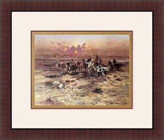
Charles M.Russell - Stolen Horses 1898 Custom Gallery FramedMynt Auctions4.6(680)See Sold PriceFeb 28, 2024
ALEXANDER CALDER (United States, 1898 - 1976). "Gaspar Hall." Lithograph, copy H.C. Signed andSetdart Auction House4.1(22)See Sold PriceMar 05, 2024
A23 United States in the Caribbean Denoyer-Geppert Social Science MapsJasper524.5(9.8k)See Sold PriceFeb 27, 2024
Two Hand-Colored 19th Century Maps of New Orleans and Louisiana, Larger- H.- 12 1/2 in., W.- 15 1/2Crescent City Auction Gallery4.3(229)See Sold PriceMar 08, 2024
Cooke, George 1801 Antique Map. United States of AmericaAlbion Auctions4.6(336)See Sold PriceMar 01, 2024
Robert H Labberton - Map of The Territory of the Present United States - The territory of theProverde Auctions4.3(3)See Sold PriceFeb 28, 2024
Stamps and Collector Plate's BooksRapid Estate Liquidators and Auction Gallery4.5(1.1k)See Sold PriceFeb 27, 2024
Map of United States of North America, 1785Antiques Online Auctions4.6(407)See Sold PriceMar 14, 2024
Vintage 1920s Rand McNally Auto Trails MapThe Benefit Shop Foundation Inc.4.3(2.9k)See Sold PriceMar 20, 2024