ATLAS of ANTIENT GEOGRAPHY by SAMUEL BUTLER 1843John McInnis Auctioneers,LLC4.6(504)See Sold PriceFeb 24, 2024
18TH C. ANTIQUE MAP: FRENCH & INDIAN WAR, FRAMEDThomaston Place Auction Galleries4.4(389)See Sold PriceFeb 24, 2024
Rand McNally Railroad Map Cabinet w/ 21 Railroad MapsRail & Road Auctions4.6(165)See Sold PriceMar 08, 2024
Keith Haring - Ink on New York Map, Best Buddies, Inscribed, Signed, and DatedSapphire Auction Gallery4.1(67)See Sold PriceMar 02, 2024
LATE 17TH C. FRENCH MAP OF THE NEW WORLD BY ALEXIS-HUBERT JAILLOT (1632-1712)Thomaston Place Auction Galleries4.4(389)See Sold PriceFeb 24, 2024
Central Railroad of New Jersey Map of Sandy Hook Route-ca. 1903JM Hobby Supply and Railroad Artifact Auctions4.4(126)See Sold PriceFeb 24, 2024
Lot of Six Mixed Atlas Box Cars-HO Scale-New in BoxJM Hobby Supply and Railroad Artifact Auctions4.4(126)See Sold PriceFeb 25, 2024
Rand McNally/Santa Fe Railroad Map of Iowa-1912JM Hobby Supply and Railroad Artifact Auctions4.4(126)See Sold PriceFeb 24, 2024
NICOLAES VISSCHER (NETHERLANDS, 1618-1709) MAP OF THE NEW WORLDThomaston Place Auction Galleries4.4(389)See Sold PriceFeb 24, 2024
17TH C. WORLD MAP BY NICOLAES VISSCHER (NETHERLANDS, 1618-1709)Thomaston Place Auction Galleries4.4(389)See Sold PriceFeb 24, 2024
Lot of Six Mixed Atlas Cabooses-HO Scale-New in BoxJM Hobby Supply and Railroad Artifact Auctions4.4(126)See Sold PriceFeb 25, 2024
Sold1884 Map of South CarolinaAuthor: Cram Title: 1884 Map of South Carolina Materials: Ink on Paper Size/Dimensions: 13.5"X11" Description: Map of South Carolina dated 1884. Printed and published by George Cram in Chicago. Part oSee Sold Price
1884 Map of South CarolinaAuthor: Cram Title: 1884 Map of South Carolina Medium: Ink on Paper Dimensions: 13.5"X11" Map of South Carolina dated 1884. Printed and published by George Cram in Chicago. Part of The People's FamilySee Sold Price
1884 Map of South CarolinaAuthor: Cram Title: 1884 Map of South Carolina Medium: Ink on Paper Dimensions: 13.5"X11" Map of South Carolina dated 1884. Printed and published by George Cram in Chicago. Part of The People's FamilySee Sold Price
1884 Map of South CarolinaAuthor: Cram Title: 1884 Map of South Carolina Medium: Ink on Paper Dimensions: 13.5"X11" Map of South Carolina dated 1884. Printed and published by George Cram in Chicago. Part of The People's FamilySee Sold Price
Sold1884 Mitchell Map of North & South CarolinaEach county individually hand colored; insets of Charleston Harbor and detailed map of the Plan of Charleston; unframed; 14"W, 11 1/2"H--Private collection, Spartanburg, South CarolinaSee Sold Price
1884 Mitchell Map of North and South Carolina -- NorthTitle/Content of Map: 1884 Mitchell Map of North and South Carolina -- North and South Carolina Cartographer: S Mitchell Year/Place: 1884, Philadelphia Size: 11.3 X 14 in. This is a very nice map of tSee Sold Price
1884 Mitchell Map of North and South Carolina -- NorthTitle/Content of Map: 1884 Mitchell Map of North and South Carolina -- North and South Carolina Cartographer: S Mitchell Year/Place: 1884, Philadelphia Size: 11.3 X 14 in. This is a very nice map of tSee Sold Price
1884 Mitchell Map of North and South Carolina -- NorthTitle: 1884 Mitchell Map of North and South Carolina -- North and South Carolina Cartographer: S Mitchell Year / Place: 1884, Philadelphia Map Dimension (in.): 11.3 X 14 in. This is a very nice map ofSee Sold Price
1884 Mitchell Map of North and South Carolina -- NorthTitle: 1884 Mitchell Map of North and South Carolina -- North and South Carolina Cartographer: S Mitchell Year / Place: 1884, Philadelphia Map Dimension (in.): 11.3 X 14 in. This is a very nice map ofSee Sold Price
Sold19th C SOUTH CAROLINA MAP - JOHN LETHEMFramed 19th c. New Railroad and County Map of South Carolina that was prepared for Industries and Resources South, published by John Lethem, Publisher, Charleston SC in 1884. Henry Stebbins was the enSee Sold Price
CIVIL WAR ERA JOHNSON'S NORTH, SOUTH CAROLINA MAPFramed "Johnson's North and South Carolina Map", by Johnson & Ward (Alvin Jewett Johnson,1827-1884), c. 1862, the two states shown in colors with vignettes of Chimney Rocks and French Broad River, TabSee Sold Price
SoldSouth Carolina Book Lot.Pennington. A Woman rice Palnter. NY 1913. Centennial of Incorporation of charleston; 1884 with fold out map and Mayors inscription tipped in. Hunter, The Palmetto State. and 1 other. Four items.See Sold Price
(4) MITCHELL ATLAS MAPS, PANAMA CANAL, C.1884(lot of 4) Unframed atlas maps, Samuel Augustus Mitchell (United States, 1790-1868), c.1884, including: (1) North and South Carolina, with inset map of Charleston harbor and plan of Charleston, 12.5"hSee Sold Price
SoldColton: Antique Pre Civil War Map South Carolina, 1861Title/Content of Map: Pre Civil War South Carolina by Colton Date Printed: 1861 Cartographer: J.H. Colton Material/Medium: Paper Size: 17 1/2" x 14" Hand colored steel engraved Map from 'Colton's GeneSee Sold Price
MAP, South Carolina, PayneSouth Carolina. John Payne, The State of South Carolina from the Best Authorities, from A New and Complete Universal Geography, 1799 (dated). Hand Color. This early map of the state is finely engravedSee Sold Price
MAP - South Carolina, Charleston. SansonColonial South Carolina, Charleston. Sanson/Mortier, Carte Particuliere de la Caroline Dressee sur les Memoires le Plus Nouveaux, 1700 (circa). Hand Color. This important, scarce map of the coastal reSee Sold Price
MAP, South Carolina, ArrowsmithSouth Carolina. Aaron Arrowsmith & Samuel Lewis, South Carolina, 1812 (circa). Hand Color. This map shows an interesting combination of both judicial districts and counties within the state. WashingtoSee Sold Price
SoldMAP, South Carolina, SansonFoundation Map of South Carolina - First State. Colonial South Carolina, Charleston. Sanson/Mortier, Carte Particuliere de la Caroline Dresse sur les Memoires le Plus Nouveaux, from Suite de Neptune FSee Sold Price
MAP, South Carolina, Arrowsmith & LewisSouth Carolina. Aaron Arrowsmith & Samuel Lewis, South Carolina, from A New and Elegant General Atlas..., 1812 (circa). Hand Color. This map shows an interesting combination of both judicial districtsSee Sold Price
SoldMAP - South Carolina. Plan of the Siege of CharleMAP - South Carolina. Plan of the Siege of Charlestown in South Carolina. London: 1787. Single sheet (image size: 270 x 300 mm). Some hand-coloring. Condition: some spotting to margin. Matted.See Sold Price
SoldMAP - South Carolina. RamsaySouth Carolina. David Ramsay, Caroline Meridionale, avec les Parties Adjacentes: pour Servir a l'Intelligence des Mouvemens des Armees Americaines et Britanniques, 1787 (published). Black & White. HanSee Sold Price
Soil Map. South Carolina Campobello SheetTitle/Content of Map: Soil Map. South Carolina Campobello Sheet Cartographer: MANGUM, A. W. / ALDERT S. ROOT Date: 1903 Publisher: U.S. DEPARTMENT OF AGRICULTURE. (BUREAU OF SOILS) Size: 18Height - 33See Sold Price
Soil Map. South Carolina Campobello SheetTitle: Soil Map. South Carolina Campobello Sheet Publication Date: 1903 Cartographer: MANGUM, A. W. / ALDERT S. ROOT Publisher: U.S. DEPARTMENT OF AGRICULTURE. (BUREAU OF SOILS) Brief Descriptions: CoSee Sold Price
Soil Map South Carolina Cherokee County sheetTitle: Soil Map South Carolina Cherokee County sheet Publication Date: 1905 Cartographer: J.A. Drake, H.L. Belden Publisher: U.S. Department of Agriculture Bureau of Soils Brief Descriptions: Size/DimSee Sold Price
Handmade Civil War Style South Carolina Ribbon CockadeConnoisseur Auctions3.9(335)See Sold PriceFeb 24, 2024
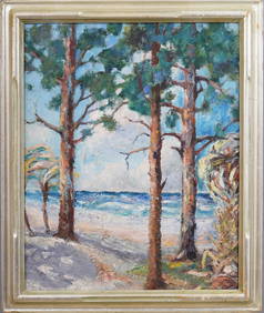
Nicely Framed Antique American Impressionist South Carolina Palm Tree Beach Seascape Oil PaintingCurated Gallery Auctions4.6(128)See Sold PriceFeb 25, 2024
Alyce Trebra, Marsh scene South CarolinaLotus International Auctions, LLC4.6(153)See Sold PriceMar 03, 2024
Alan Joyner - Beaufort South Carolina, Oil on CanvasSapphire Auction Gallery4.1(67)See Sold PriceMar 02, 2024
April 10 1778 2s6d South Carolina Colonial FR#SC-145 XF45 PPQMynt Auctions4.6(689)See Sold PriceFeb 24, 2024
1872 $1 South Carolina Columbia Haxby# OBSSCCR3 PMG Gem 65 EPQMynt Auctions4.6(689)See Sold PriceFeb 25, 2024
1872 $50 South Carolina Columbia Haxby# OBSSCCR8 PMGGem 66 EPQMynt Auctions4.6(689)See Sold PriceFeb 26, 2024
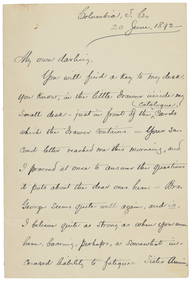
[RECONSTRUCTION]. A group of documents related to the McKinlay family of South Carolina, incl.Freeman's | Hindman4.4(1.6k)See Sold PriceFeb 27, 2024
Carey, pub. 1796 - Map of The State of South CarolinaTrillium Antique Prints & Rare Books4.5(30)See Sold PriceFeb 24, 2024
Carey, pub. 1796 - Map of the Tennassee State formerly part of North Carolina (Tennessee)Trillium Antique Prints & Rare Books4.5(30)See Sold PriceFeb 24, 2024
GEORGE ROGERS SOUTH CAROLINA GAMECOCKS 1980 HEISMAN WHITE JSA/COA SIGNED JERSEYMynt Auctions4.6(689)See Sold PriceMar 01, 2024
Deebo Samuel Autographed South Carolina Gamecocks Speed Mini Helmet- JSA *BlackMynt Auctions4.6(689)See Sold PriceMar 02, 2024
Michael P. Smith (American/Louisiana, 1937-2008), "Binding for Baptism, Holy Family, South Carolina"Crescent City Auction Gallery4.3(231)See Sold PriceMar 09, 2024
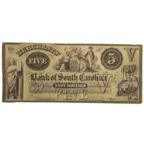
1850s-61 $5 Bank of the State of South Carolina Obsolete Note PMG Choice Fine 15BK Auctions4.7(1.4k)See Sold PriceFeb 25, 2024
Lionel LTI 6-19987 9700 I Love South Carolina Boxcar w/ OBGregory Hake Auctions4.5(62)See Sold PriceMar 06, 2024


![[RECONSTRUCTION]. A group of documents related to the McKinlay family of South Carolina, incl. (1 of 2)](https://p1.liveauctioneers.com/197/319238/171468094_1_x.jpg?height=282&quality=70&version=1707520367)