ATLAS of ANTIENT GEOGRAPHY by SAMUEL BUTLER 1843John McInnis Auctioneers,LLC4.6(502)See Sold PriceFeb 24, 2024
18TH C. ANTIQUE MAP: FRENCH & INDIAN WAR, FRAMEDThomaston Place Auction Galleries4.4(386)See Sold PriceFeb 24, 2024
Rand McNally Railroad Map Cabinet w/ 21 Railroad MapsRail & Road Auctions4.6(165)See Sold PriceMar 08, 2024
Keith Haring - Ink on New York Map, Best Buddies, Inscribed, Signed, and DatedSapphire Auction Gallery4(67)See Sold PriceMar 02, 2024
LATE 17TH C. FRENCH MAP OF THE NEW WORLD BY ALEXIS-HUBERT JAILLOT (1632-1712)Thomaston Place Auction Galleries4.4(386)See Sold PriceFeb 24, 2024
Central Railroad of New Jersey Map of Sandy Hook Route-ca. 1903JM Hobby Supply and Railroad Artifact Auctions4.4(126)See Sold PriceFeb 24, 2024
Lot of Six Mixed Atlas Box Cars-HO Scale-New in BoxJM Hobby Supply and Railroad Artifact Auctions4.4(126)See Sold PriceFeb 25, 2024
Rand McNally/Santa Fe Railroad Map of Iowa-1912JM Hobby Supply and Railroad Artifact Auctions4.4(126)See Sold PriceFeb 24, 2024
NICOLAES VISSCHER (NETHERLANDS, 1618-1709) MAP OF THE NEW WORLDThomaston Place Auction Galleries4.4(386)See Sold PriceFeb 24, 2024
17TH C. WORLD MAP BY NICOLAES VISSCHER (NETHERLANDS, 1618-1709)Thomaston Place Auction Galleries4.4(386)See Sold PriceFeb 24, 2024
Lot of Six Mixed Atlas Cabooses-HO Scale-New in BoxJM Hobby Supply and Railroad Artifact Auctions4.4(126)See Sold PriceFeb 25, 2024
17 MAPS BY HERMAN MOLL CIRCA 1700Rare early 18th century map book containing 17 individual maps of the world by cartographer Herman Moll (English 1654-1732). Leather bound hard cover (loose, wear) is 25 x 12 inches in size. Most doubSee Sold Price
SoldMap, engraved, Scotland, hand-colored, 1720Map, engraved, Scotland, hand-colored, 1720 Title: Map of Scotland Artist: Herman Moll Publisher: Hermom Moll Engraver: Hermon Moll Description: Hand colored map by Herman Moll,17 the century. Date: 1See Sold Price
SoldHERMAN MOLL ANTIQUE MAP OF GREAT BRITAIN CIRCA 1725A FINE HERMAN MOLL MAP OF GREAT BRITAIN CIRCA 1725. A large and impressive map of Great Britain with hand coloring. Being “A New Map of GREAT BRITAIN According to the Newest and Most Exact ObservatiSee Sold Price
SoldDenmark, Herman Moll 1700Title: Denmark Subject: Denmark Maker: Herman Moll Date: 1700 Materials: Hand colored copperplate engraving Size: 7.5 x 10.5 inches Herman Moll (1654-1732) was a London cartographer, engraver, and pubSee Sold Price
SoldMap, Herman MollHerman Moll (British, c. 1654-1732), "To the Right Honorable William Lord Cowper... This Map of Asia," circa 1720, hand-colored engraving, image (sight): 24.5"h x 43"w, overall (with mat/unframed): 30See Sold Price
SoldMOLL - Map of the East-Indies.MAPS. - MOLL, Herman. A Map of the East-Indies.London: printed for H. Moll, [circa 1720]. Engraved map (sheet size: 648x1042 mm.), hand-colored in outline. Condition: margins browned and withSee Sold Price
Sold[MAP] HUET, PIERRE DANIEL Paradis Terrestre [Midd[MAP] HUET, PIERRE DANIEL Paradis Terrestre [Middle East including Israel] Printed map. 17 x 19 1/2 inches. Amsterdam: Pierre Mortier, [circa 1700]See Sold Price
SoldMAPS. - MOLL, Herman. Map of Asia.MAPS. - MOLL, Herman. Map of Asia.London: printed for H. Moll, D. Midwinter, T. Bowles and P. Overton, [circa 1720]. Engraved map (sheet size: 644x1030 mm) hand-colored in outline. Condition:See Sold Price
SoldMOLL - Map of Moscovy, Poland, Little Tartary anMAPS. - MOLL, Herman. Map of Moscovy, Poland, Little Tartary and ye Black Sea ...; A New Map of Denmark and Sweden ...London: printed for H. Moll, D. Midwinter, T. Bowles and P. Overton, [circSee Sold Price
SoldMOLL - Map of the World.MAPS. - MOLL, Herman. A New and Correct Map of the World.London: printed for H. Moll, D. Midwinter, T. Bowles and P. Overton, [circa 1720]. Engraved map (sheet size: 644x1025 mm.), hand-coloreSee Sold Price
Moll (Herman) Atlas GeographusMoll (Herman) Atlas Geographus,17 folding engraved maps hand-coloured in outline, 4 engraved plates, some folding, 1 folding table, browning throughout, contemporary calf, worn at spine and coSee Sold Price
SoldMOLL- Map of Spain & PortugalMAPS. - MOLL, Herman. A New and Exact Map of Spain & Portugal ... 1714 ; A New Map of Italy... 1711London: printed for H. Moll, D. Midwinter, T. Bowles and P. Overton, [circa 1720]. 2 engravedSee Sold Price
SoldMOLL - Map of the United Provinces, or NetherlandMAPS. - MOLL, Herman. A New and Exact map of the United Provinces, or Netherlands.London: printed for H. Moll, D. Midwinter and T. Bowles, [circa 1720]. Engraved map (sheet size: 648x1037 mm),See Sold Price
SoldMOLL - Map of Europe ... ; Map of Africa ...MAPS. - MOLL, Herman. Map of Europe ... ; Map of Africa ...London: printed for H. Moll, D. Midwinter, T. Bowles and P. Overton, "1708"- [n.d., but both published circa 1720]. 2 engraved maps (See Sold Price
SoldMoll map of Bermuda c.1708Title: A Map of ye Island of Bermudos, Divided into its Tribes, with the Castles, Forts &c. Author: Moll, Herman Description: Copper-engraved map, hand-colored (later). 17.5x10 cm. (7x4"). Charming liSee Sold Price
SoldIreland.- Moll (Herman) A Set of Twenty New and CorrectIreland.- Moll (Herman) A Set of Twenty New and Correct Maps of Ireland, first edition, printed title-page, folding engraved general map of Ireland, 17 engraved county/province maps and engraved ListSee Sold Price
SoldMOLL, HERMAN. A New Map of Great Britain.MOLL, HERMAN. A New Map of Great Britain. Two-sheet engraved map, 620x1020 mm, ample margins; nicely hand-colored in outline. nice copy. London, circa 1720 All items are offered for sale subject to SwSee Sold Price
Sold2 Hand Colored MapsThomas Jefferys map illustrating Europe and Turkey. Herman Moll: "Atlas Minor." (9.5" X 11.5" (15.25" X 17.25")) (East 86 Street Estate)See Sold Price
SoldHAND COLORED MAP OF EUROPE G. Valck, circa early 17HAND COLORED MAP OF EUROPE G. Valck, circa early 1700's sight 20'x24"See Sold Price
SoldMOLL, HERMAN. Group of 14 engraved maps of NewMOLL, HERMAN. Group of 14 engraved maps of New World subjects, each approximately 210x280 mm unless otherwise noted, all with wide or ample margins; all hand-colored in outline. London, circa 1729 FloSee Sold Price
SoldMap, of the Netherlands Circa 1734Description: Map of "The Austrian and French Netherlands attributed to Emanuel Bowen and Herman Moll. History: Moll produced his earliest maps from studying cartographers such as John Senex and EmanueSee Sold Price
SoldH. Moll, circa 1736, Map of Great BritainConstructed in 2 panels, hand colored. Tears to edges at folds. Staining and mold to right side. 39-1/2" high x 25" wide. IMPORTANT: Before bidding, please read the terms and conditions. When you regiSee Sold Price
SoldH. Moll, circa 1730s, Maps of Spain & PortugalAlso includes map of France.Spain & Portugal: Dedicated to His Grace John, Duke of Argile. Constructed in 4 panels, hand colored. Tears to bottom at panel creases; adhesive has failed down middle paneSee Sold Price
North America by Herman Moll, 1716Title: North America by Herman Moll, 1716 Date Printed: 1716 Cartographer: Herman Moll Material/Medium: Original copper engraving Size: 17 1/4" x 20 1/2" Additional Information: North America publisheSee Sold Price
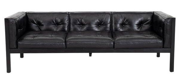
George Nelson Herman Miller Leather "Cube" SofaAuctions at Showplace4.5(726)See Sold PriceMar 03, 2024
Russian Wooden Icon with Virgin Donskaya with Silver BasmaTimeLine Auctions Ltd.4.5(183)See Sold PriceMar 08, 2024
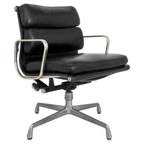
Eames x Miller Soft Pad Aluminum Executive ChairAuctions at Showplace4.5(726)See Sold PriceMar 17, 2024
Johann Homann Hand-Colored Map Engraving, c. 1730Auctions at Showplace4.5(726)See Sold PriceMar 17, 2024
Herman Moll A New Map of Ye North Parts of AmericaWillow Auction House4.5(283)See Sold PriceMar 14, 2024


![[MAP] HUET, PIERRE DANIEL Paradis Terrestre [Midd (1 of 1)](https://p1.liveauctioneers.com/292/11031/2709043_1_x.jpg?height=282&quality=70&version=1162521581)