ATLAS of ANTIENT GEOGRAPHY by SAMUEL BUTLER 1843John McInnis Auctioneers,LLC4.6(502)See Sold PriceFeb 24, 2024
18TH C. ANTIQUE MAP: FRENCH & INDIAN WAR, FRAMEDThomaston Place Auction Galleries4.4(386)See Sold PriceFeb 24, 2024
Rand McNally Railroad Map Cabinet w/ 21 Railroad MapsRail & Road Auctions4.6(165)See Sold PriceMar 08, 2024
Keith Haring - Ink on New York Map, Best Buddies, Inscribed, Signed, and DatedSapphire Auction Gallery4(67)See Sold PriceMar 02, 2024
LATE 17TH C. FRENCH MAP OF THE NEW WORLD BY ALEXIS-HUBERT JAILLOT (1632-1712)Thomaston Place Auction Galleries4.4(386)See Sold PriceFeb 24, 2024
Central Railroad of New Jersey Map of Sandy Hook Route-ca. 1903JM Hobby Supply and Railroad Artifact Auctions4.4(126)See Sold PriceFeb 24, 2024
Lot of Six Mixed Atlas Box Cars-HO Scale-New in BoxJM Hobby Supply and Railroad Artifact Auctions4.4(126)See Sold PriceFeb 25, 2024
Rand McNally/Santa Fe Railroad Map of Iowa-1912JM Hobby Supply and Railroad Artifact Auctions4.4(126)See Sold PriceFeb 24, 2024
NICOLAES VISSCHER (NETHERLANDS, 1618-1709) MAP OF THE NEW WORLDThomaston Place Auction Galleries4.4(386)See Sold PriceFeb 24, 2024
17TH C. WORLD MAP BY NICOLAES VISSCHER (NETHERLANDS, 1618-1709)Thomaston Place Auction Galleries4.4(386)See Sold PriceFeb 24, 2024
Lot of Six Mixed Atlas Cabooses-HO Scale-New in BoxJM Hobby Supply and Railroad Artifact Auctions4.4(126)See Sold PriceFeb 25, 2024
SoldMunster c1580 map of Greece & W. TurkeyFrom Sebastian Munster’s Cosmographia. “Neuw Griechenlandt mit andern anstossenden Landern wie es zu unsern zeiten beschriben ist.” Late 16th century double-page woodblock map of Greece, the AegSee Sold Price
Munster c1580 map of Greece & W. TurkeyFrom Sebastian Munster’s Cosmographia. “Neuw Griechenlandt mit andern anstossenden Landern wie es zu unsern zeiten beschriben ist.” Late 16th century double-page woodblock map of Greece, the AegSee Sold Price
Munster's Cosmographia: Map of Greece & Turkey, 1580Early German edition of Greece and western Turkey from Munster’s Cosmographia. Sebastian Munster c1580. 10 x 13.5. Neuw Griechenlandt mit andern anstossenden Landern wie es zu unsern zeiten beschribSee Sold Price
SoldMunster woodcut map of Greece c.1580Heading: (Map - Greece) Author: Münster, Sebastian Title: New Griechen land mit andern anstossenden Landern wie es zu unsern zeiten beschriben ist Place Published: [Basle] Publisher: Date PublishSee Sold Price
Munster woodcut map of Greece c.1580Heading: Author: Münster, Sebastian Title: New Griechen land mit andern anstossenden Landern wie es zu unsern zeiten beschriben ist Place Published: [Basle] Publisher: Date Published: c.1580See Sold Price
Sebastian Munster, "Nova Graecia XXII Nova Tabula"Year 1552. Rare map of Greece and Turkey-based on Ptolemy's observations. Extracted from the "Cosmographia Universalis", printed in Basel in the 16th century. Technique: Woodcut Plate size: 29.2 x 37.See Sold Price
SoldMallet: Map of Turkey in Europe, 1719Map: Tvrqvie En Europe | Die Europaeische Turckey Publication Date: 1719 Authors: MALLET, ALAIN MANESSON Size: Octavo – 5.75 H x 4.00 W Inches Engraved outline map of Greece and the Balkans. PleaseSee Sold Price
Sold[Munster (Sebastian)] Neiuw Griechenlandt[Munster (Sebastian)] Neiuw Griechenlandt Greece and part of Turkey, woodcut map, 260 x 350mm., short split to upper margin of central vertical fold, 2 small holes to lower margin light browniSee Sold Price
Sold[Munster (Sebastian)] Griechlandt[Munster (Sebastian)] Griechlandt eastern Europe, including Greece, part of Turkey, Dalmatia, Albania, etc., and Crete, 2 woodcut maps, 160 x 130mm., and 77 x 158mm., respectively, German textSee Sold Price
Bartholomew: Map of Turkey in Europe, 1879Map of Turkey in Europe, Greece, Roumania, Servia, Montenegro &C. A. & C. Black, Bartholomew, J. 1879. Two corners repaired. Folio – 22.50 H x 16.80 W Inches Please note that this lot has a confidenSee Sold Price
SoldBlackie, W. G. 1882 Lot of 10 MapsIncl Europe, North Atlantic, Denmark, Persia, Canada, Peru, Bolivia, South America, Turkey/Greece, Russia, and Italy. Lithograph Maps Published 1882 by Blackie & Son, London for "The Comprehensive AtlSee Sold Price
Blackie, W. G. 1882 Lot of 10 MapsIncl Europe, North Atlantic, Denmark, Persia, Canada, Peru, Bolivia, South America, Turkey/Greece, Russia, and Italy. Lithograph Maps Published 1882 by Blackie & Son, London for "The Comprehensive AtlSee Sold Price
SoldTwo Maps by Johnson & Browning, "Austria, Turkey,Two Maps by Johnson & Browning, "Austria, Turkey, Greece," 1859; together with "Northern and Southern Italy," 1860-1863, hand colored, Italy- H.- 26 1/2 in., W.- 36 in., Austria- H.- 18 in., W.- 26 1/See Sold Price
Turkey in Europe & GreeceReserve Reduced! Title: Turkey in Europe & Greece Publication Date: 1869 Cartographer: CHAMBERS, W. & R. Publisher: J.B. LIPPINCOTT & CO. Size: 11.25X8.6 Double-page map from Chambers's Atlas to accomSee Sold Price
MAP - Greece & Turkey. OrteliusNortheastern Greece & Northwestern Turkey. Abraham Ortelius, Thraciae Veteris Typus, 1624 (published). Black & White. Handsome map of ancient Thrace based on Gastaldi's 1560 map of South East Europe,See Sold Price
SoldMAP - Greece & Western Turkey. JanssonGreece & Western Turkey. Jan Jansson, Hellas seu Graecia Sophiani, 1741 (published). Hand Color. This uncommon map is Jansson's copy of Hondius' map, which in turn was based on Abraham Ortelius' map.See Sold Price
Munster map of Greece c.1550Title: La nouvelle Grece selon toutes les regions & provinces d'icelle tant deca que de la l'Hellespont Author: Münster, Sebastian Description: Woodcut map. 34x42 cm. (13½x16½")."Modern" map of GreSee Sold Price
Sold1843 Handcolored Map of Greece W. & A.K. JohnstonDESCRIPTION: Handcolored map of Greece or Hellas, Ionian Islands and Crete by A.K. Johnston. Engraved by W. & A.K. Johnston as marked lower right. Marked lower center "Edinburgh: John Johnstone, and WSee Sold Price
SoldMid to Near East: 18 Hand colored Maps[Mid & Near East]. 18 hand-colored maps featuring Greece, Turkey, and countries in the Middle East, mostly from various editions of the Johnson Family Atlas, 1850s - 1860s. Some duplicates, each approSee Sold Price
Sold1552 Munster Map of Northern Greece and Balkans -- Tabula Europae IXTitle: 1552 Munster Map of Northern Greece and Balkans -- Tabula Europae IX Cartographer: Munster / Ptolemy Year / Place: 1552. Basel Map Dimension (in.): 11 X 13.5 in. This is fantastic, somewhat rarSee Sold Price
1808 Wilkinson Map of Northern Greece, Turkey andReserve Reduced! Title/Content of Map:1808 Wilkinson Map of Northern Greece, Turkey and Macedonia -- Graecia Pars Septentrionalis alitee Macedonia, Thessallia & Epirus cum Thracia Date:1806, London CaSee Sold Price
1864 Austria, Turkey, Greece MapAuthor: Johnson Title: 1864 Austria, Turkey, Greece Map Medium: Ink on Paper Dimensions: 26"X18" Map of Austria, Greece and Turkey in Europe dated 1864. Engraved by A.J.Johnson. Published by Johnson aSee Sold Price
1808 Wilkinson Map of Northern Greece, Turkey andTitle/Content of Map: 1808 Wilkinson Map of Northern Greece, Turkey and Macedonia -- Graecia Pars Septentrionalis alitee Macedonia, Thessallia & Epirus cum Thracia Date: 1806, London Cartographer: R WSee Sold Price
1808 Wilkinson Map of Northern Greece, Turkey andTitle/Content of Map: 1808 Wilkinson Map of Northern Greece, Turkey and Macedonia -- Graecia Pars Septentrionalis alitee Macedonia, Thessallia & Epirus cum Thracia Date Printed: 1806, London CartograpSee Sold Price
Vintage Copper Vessel W Handle TURKEY 15.5inThe Benefit Shop Foundation Inc.4.3(2.9k)See Sold PriceFeb 28, 2024
Bogdan Kaudetzky (German 1898 - 1964) Oil painting landscape w/ peacock turkeyGlobal Auctions Company4.3(36)See Sold PriceMar 03, 2024
Early Pennsylvania Railroad Literature - 1881 New York and Chicago Limited Timetable Brochure andRail & Road Auctions4.6(165)See Sold PriceMar 07, 2024
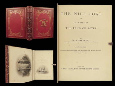
1880 Niles Boat Egypt Voyages Sphinx Pyramids Valley of Kings Illustrated MAPSSchilb Antiquarian Rare Books4.8(421)See Sold PriceMar 31, 2024
Vintage Vanguard Studio wall map, dated 1968South Jersey Auction by Babington Auction Inc4.6(122)See Sold PriceFeb 25, 2024
Rand McNally Railroad Map Cabinet w/ 21 Railroad MapsRail & Road Auctions4.6(165)See Sold PriceMar 08, 2024
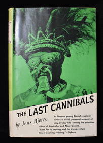
THE LAST CANNIBALS by JENS BJERRE 1957 Fine or Near FineNorth American Artifact Auctions4.6(182)See Sold PriceApr 20, 2024
1738 BIBLE in DUTCH ILLUSTRATED w/ MAPS MASSIVE FOLIO in DUTCH antique BIBLIAJasper524.5(9.8k)See Sold PriceFeb 27, 2024
1749-1771 HISTORY OF ROMAN EMPERORS 12 VOLUMES antique ILLUSTRATED w/ MAPSJasper524.5(9.8k)See Sold PriceFeb 27, 2024
Map of Turkey from Arabic and Persia, 1701 by Gillaume de Lisle, ParisAntiques Online Auctions4.6(407)See Sold PriceMar 14, 2024


![[Munster (Sebastian)] Neiuw Griechenlandt (1 of 1)](https://p1.liveauctioneers.com/410/8611/1592309_1_x.jpg?height=282&quality=70)
![[Munster (Sebastian)] Griechlandt (1 of 1)](https://p1.liveauctioneers.com/410/8611/1592310_1_x.jpg?height=282&quality=70)