ATLAS of ANTIENT GEOGRAPHY by SAMUEL BUTLER 1843John McInnis Auctioneers,LLC4.5(505)See Sold PriceFeb 24, 2024
18TH C. ANTIQUE MAP: FRENCH & INDIAN WAR, FRAMEDThomaston Place Auction Galleries4.4(393)See Sold PriceFeb 24, 2024
Rand McNally Railroad Map Cabinet w/ 21 Railroad MapsRail & Road Auctions4.6(165)See Sold PriceMar 08, 2024
Keith Haring - Ink on New York Map, Best Buddies, Inscribed, Signed, and DatedSapphire Auction Gallery4(67)See Sold PriceMar 02, 2024
LATE 17TH C. FRENCH MAP OF THE NEW WORLD BY ALEXIS-HUBERT JAILLOT (1632-1712)Thomaston Place Auction Galleries4.4(393)See Sold PriceFeb 24, 2024
Central Railroad of New Jersey Map of Sandy Hook Route-ca. 1903JM Hobby Supply and Railroad Artifact Auctions4.4(127)See Sold PriceFeb 24, 2024
Lot of Six Mixed Atlas Box Cars-HO Scale-New in BoxJM Hobby Supply and Railroad Artifact Auctions4.4(127)See Sold PriceFeb 25, 2024
Rand McNally/Santa Fe Railroad Map of Iowa-1912JM Hobby Supply and Railroad Artifact Auctions4.4(127)See Sold PriceFeb 24, 2024
NICOLAES VISSCHER (NETHERLANDS, 1618-1709) MAP OF THE NEW WORLDThomaston Place Auction Galleries4.4(393)See Sold PriceFeb 24, 2024
17TH C. WORLD MAP BY NICOLAES VISSCHER (NETHERLANDS, 1618-1709)Thomaston Place Auction Galleries4.4(393)See Sold PriceFeb 24, 2024
Lot of Six Mixed Atlas Cabooses-HO Scale-New in BoxJM Hobby Supply and Railroad Artifact Auctions4.4(127)See Sold PriceFeb 25, 2024
Sold1861 World map with USA centric view point. By JohnsonTitle: 1861 World map with USA centric view point. By Johnson Date/Period: 1861 Materials: Steel engraved. Size: 26 1/2 x 18”. By A. J. Johnson & J. H Colton. From 'Johnson's New Illustrated FamilySee Sold Price
1861 World map with USA centric view point. By JohnsonTitle: 1861 World map with USA centric view point. By Johnson Date/Period: 1861 Materials: Steel engraved. Size: 26 1/2 x 18”. By A. J. Johnson & J. H Colton. From 'Johnson's New Illustrated FamilySee Sold Price
1861 World map with USA centric view point. By JohnsonTitle: 1861 World map with USA centric view point. By Johnson Date/Period: 1861 Materials: Steel engraved. Size: 26 1/2 x 18”. By A. J. Johnson & J. H Colton. From 'Johnson's New Illustrated FamilySee Sold Price
World map with USA centric view point. By JohnsonTitle: World map with USA centric view point. By Johnson Date/Period: 1861 Materials: Steel engraved. Size: 26 1/2 x 18”. By A. J. Johnson & J. H Colton. From "Johnson's New Illustrated Family AtlasSee Sold Price
World map with USA centric view point. By JohnsonTitle: World map with USA centric view point. By Johnson Date/Period: 1861 Materials: Steel engraved. Size: 26 1/2 x 18”. By A. J. Johnson & J. H Colton. From "Johnson's New Illustrated Family AtlasSee Sold Price
SoldWORLD MAP 1861 BY JOHNSON & WARDJohnson's Western and Eastern Hemispheres, sight size 16 x 26.5, overall 26 x 34.5 inches.See Sold Price
1861. World Map in Double Hemisphere Projection. By Johnson and BrowningTitle: 1861. World Map in Double Hemisphere Projection. By Johnson and Browning Date/Period: 1861 Materials: Steel engraved Size: 26 x 18” This hand-colored, steel-engraved map was created by JoSee Sold Price
SoldMAP: Johnsons The World on Mercators ProjectionMaps“Johnson’s Map of The World on Mercator’s Projection” c. 1861, “Johnson’s Map of The World on Mercator’s Projection,” published by Johnson and Ward,See Sold Price
SoldMAP: Johnsons The World on Mercators ProjectionMaps“Johnson’s Map of The World on Mercator’s Projection” c. 1861, “Johnson’s Map of The World on Mercator’s Projection,” published by Johnson and Ward,See Sold Price
SoldMAP: Johnsons The World on Mercators ProjectionHistoric Maps"Johnson's Map of The World on Mercator's Projection" c. 1861, "Johnson's Map of The World on Mercator's Projection," published by Johnson and Ward, New YoSee Sold Price
SoldMap: Johnson's World on Mercators ProjectionHistoric Maps"Johnson's Map of The World on Mercator's Projection" c. 1861, "Johnson's Map of The World on Mercator's Projection," published by Johnson and Ward, New YoSee Sold Price
SoldMap: Johnson's World on Mercators ProjectionHistoric Maps"Johnson's Map of The World on Mercator's Projection" c. 1861, "Johnson's Map of The World on Mercator's Projection," published by Johnson and Ward, New YoSee Sold Price
SoldMap: Johnsons World on Mercators ProjectionHistoric Maps"Johnson's Map of The World on Mercator's Projection" c. 1861, "Johnson's Map of The World on Mercator's Projection," published by Johnson and Ward, New YoSee Sold Price
SoldMap: Johnson's World on Mercators ProjectionHistoric Maps"Johnson's Map of The World on Mercator's Projection" c. 1861, "Johnson's Map of The World on Mercator's Projection," published by Johnson and Ward, New YoSee Sold Price
Johnson's World on Mercator's Projection. Americas-centric 1861 old mapCAPTION PRINTED BELOW PICTURE: 'Johnson's Map of the World on Mercator's Projection' DATE PRINTED: 1861 IMAGE SIZE: Approx 43.5 x 66.0cm, 17 x 26 inches (Large); Please note that this is a folding mapSee Sold Price
Sold1861 JOHNSON AND BROWNING TWIN HEMISPHERE WORLD MAPSuccessors of the Colton Map Co. Alaska is still Russian on this map, Antarctic and parts of Africa are still terra incognita. 16 x 26.5 inch sight size. Professionally matted in archival material.See Sold Price
Johnson's Western & Eastern Hemispheres. World 1861 old antique map plan chartCAPTION PRINTED BELOW PICTURE: 'Johnson's Western Hemisphere // Johnson's Eastern Hemisphere' DATE PRINTED: 1861 IMAGE SIZE: Approx 40.5 x 68.0cm, 16 x 26.75 inches (Large); Please note that this is aSee Sold Price
SoldTwo Hand Embroidered MapsTwo Hand Embroidered Maps, a World Map (January 1929) and a USA Map (January 1930), embroidery on linen. Size: 23" x 33", 58 x 84 cm (sight), 25" x 35", 64 x 89 cm (frame). Kristina Barbara Johnson EsSee Sold Price
Sold1868 EARLY JOHNSON & WARD WORLD MAP ATLAS WORNIncludes Johnson's map of Mercator's Projection, physical geography, historical and statistical views, meteorology, plants, river systems, military and war department maps, states, and countries. VerySee Sold Price
Sold1868 EARLY JOHNSON & WARD WORLD MAP ATLAS WORNIncludes Johnson's map of Mercator's Projection, physical geography, historical and statistical views, meteorology, plants, river systems, military and war department maps, states, and countries. VerySee Sold Price
Sold1861 World animal kingdoms. World productivity andTitle: 1861 World animal kingdoms. World productivity and commerce by Johnson Date/Period: 1861 Materials: Steel engraved. Size: 18 x 13 1/2” By A. J. Johnson & J. H Colton. From 'Johnson's New IlluSee Sold Price
1861 World in double hemisphereTitle: 1861 World in double hemisphere Date/Period: 1861 Materials: Steel engraved. Size: 27x17 3/4” By A. J. Johnson & J. H Colton. From 'Johnson's New Illustrated Family Atlas' published in New YoSee Sold Price
1861 World in double hemisphereTitle: 1861 World in double hemisphere Date/Period: 1861 Materials: Steel engraved. Size: 27x17 3/4” By A. J. Johnson & J. H Colton. From 'Johnson's New Illustrated Family Atlas' published in New YoSee Sold Price
1861 World in double hemisphereTitle: 1861 World in double hemisphere Date/Period: 1861 Materials: Steel engraved. Size: 27x17 3/4” By A. J. Johnson & J. H Colton. From 'Johnson's New Illustrated Family Atlas' published in New YoSee Sold Price
Great Western RY November 1, 1880 Public TimetableJM Hobby Supply and Railroad Artifact Auctions4.4(127)See Sold PriceFeb 24, 2024
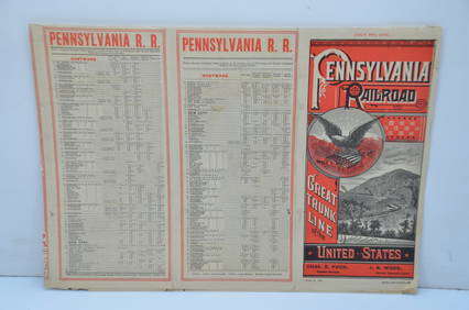
Pennsylvania Railroad July 8, 1885 Public TimetableJM Hobby Supply and Railroad Artifact Auctions4.4(127)See Sold PriceFeb 24, 2024
The O'Brien Shourds Winter-Plumage Plover Decoy by Harry V. Shourds (1861-1920)Copley Fine Art Auctions4.5(40)See Sold PriceFeb 24, 2024
The Johnson Johnson Yellowlegs Decoy by J. Taylor Johnson (1853-1929)Copley Fine Art Auctions4.5(40)See Sold PriceFeb 24, 2024
17TH C. WORLD MAP BY NICOLAES VISSCHER (NETHERLANDS, 1618-1709)Thomaston Place Auction Galleries4.4(393)See Sold PriceFeb 24, 2024
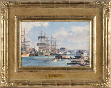
JOHN STOBART (Massachusetts/Florida/England, 1929-2023), "Victoria, View from Songhee Point, 1891".,Eldred's4.7(419)See Sold PriceFeb 27, 2024
[Ambrotype] “Mr. Grant” w/ Bowie KnifeFleischer's Auctions4.5(56)See Sold PriceMar 16, 2024
Vintage Full Color World Map LithographThe Benefit Shop Foundation Inc.4.3(2.9k)See Sold PriceFeb 28, 2024
Nova Totius Full Color Geographical World MapThe Benefit Shop Foundation Inc.4.3(2.9k)See Sold PriceFeb 28, 2024
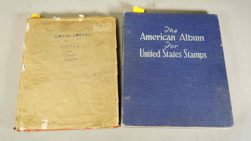
Two Stamp Albums: "United States of America" & World Stamp CollectionNeo FineArts Inc4.4(13)See Sold PriceFeb 25, 2024
Antique German Kampen Town Color Copper EtchingHill Auction Gallery 4.7(1k)See Sold PriceFeb 28, 2024
[WORLD WAR II – OKINAWA]. Okinawa Shima Western Beaches Top...Potter & Potter Auctions4.6(545)See Sold PriceMar 07, 2024
Carey, pub. 1796 - Map of GeorgiaTrillium Antique Prints & Rare Books4.5(32)See Sold PriceFeb 24, 2024
Carey, pub. 1796 - Map of The State of South CarolinaTrillium Antique Prints & Rare Books4.5(32)See Sold PriceFeb 24, 2024
Carey, pub. 1796 - Map of KentuckyTrillium Antique Prints & Rare Books4.5(32)See Sold PriceFeb 24, 2024
Carey, pub. 1796 - Map of the Tennassee State formerly part of North Carolina (Tennessee)Trillium Antique Prints & Rare Books4.5(32)See Sold PriceFeb 24, 2024
De Jode, Rare, pub. 1593 - Map of Africa (Africae Vera Forma, et Situs)Trillium Antique Prints & Rare Books4.5(32)See Sold PriceFeb 24, 2024
Kawase Hasui Woodblock - Modan Viewpoint, KoreaFloating World Auctions4.7(236)See Sold PriceMar 01, 2024


![[Ambrotype] “Mr. Grant” w/ Bowie Knife (1 of 1)](https://p1.liveauctioneers.com/7226/317626/170485462_1_x.jpg?height=282&quality=70&version=1706368022)


![[WORLD WAR II – OKINAWA]. Okinawa Shima Western Beaches Top... (1 of 1)](https://p1.liveauctioneers.com/928/318880/171361141_1_x.jpg?height=282&quality=70&version=1707501302)