ATLAS of ANTIENT GEOGRAPHY by SAMUEL BUTLER 1843John McInnis Auctioneers,LLC4.6(504)See Sold PriceFeb 24, 2024
18TH C. ANTIQUE MAP: FRENCH & INDIAN WAR, FRAMEDThomaston Place Auction Galleries4.4(389)See Sold PriceFeb 24, 2024
Rand McNally Railroad Map Cabinet w/ 21 Railroad MapsRail & Road Auctions4.6(165)See Sold PriceMar 08, 2024
Keith Haring - Ink on New York Map, Best Buddies, Inscribed, Signed, and DatedSapphire Auction Gallery4.1(67)See Sold PriceMar 02, 2024
LATE 17TH C. FRENCH MAP OF THE NEW WORLD BY ALEXIS-HUBERT JAILLOT (1632-1712)Thomaston Place Auction Galleries4.4(389)See Sold PriceFeb 24, 2024
Central Railroad of New Jersey Map of Sandy Hook Route-ca. 1903JM Hobby Supply and Railroad Artifact Auctions4.4(126)See Sold PriceFeb 24, 2024
Lot of Six Mixed Atlas Box Cars-HO Scale-New in BoxJM Hobby Supply and Railroad Artifact Auctions4.4(126)See Sold PriceFeb 25, 2024
Rand McNally/Santa Fe Railroad Map of Iowa-1912JM Hobby Supply and Railroad Artifact Auctions4.4(126)See Sold PriceFeb 24, 2024
NICOLAES VISSCHER (NETHERLANDS, 1618-1709) MAP OF THE NEW WORLDThomaston Place Auction Galleries4.4(389)See Sold PriceFeb 24, 2024
17TH C. WORLD MAP BY NICOLAES VISSCHER (NETHERLANDS, 1618-1709)Thomaston Place Auction Galleries4.4(389)See Sold PriceFeb 24, 2024
Lot of Six Mixed Atlas Cabooses-HO Scale-New in BoxJM Hobby Supply and Railroad Artifact Auctions4.4(126)See Sold PriceFeb 25, 2024
Sold1861 North America. By JohnsonTitle: 1861 North America. By Johnson Date/Period: 1861 Materials: Steel engraved. Size: 26 1/2 x 17 3/4” 1861. By A. J. Johnson & J. H Colton. From "Johnson's New Illustrated Family Atlas' publisheSee Sold Price
1861 North America. By JohnsonTitle: 1861 North America. By Johnson Date/Period: 1861 Materials: Steel engraved. Size: 26 1/2 x 17 3/4” 1861. By A. J. Johnson & J. H Colton. From "Johnson's New Illustrated Family Atlas' publisheSee Sold Price
1861 North America. By JohnsonTitle: 1861 North America. By Johnson Date/Period: 1861 Materials: Steel engraved. Size: 26 1/2 x 17 3/4” 1861. By A. J. Johnson & J. H Colton. From "Johnson's New Illustrated Family Atlas' publisheSee Sold Price
SoldMap, c. 1861, Johnsons North AmericaMaps“Johnson’s North America” Published Circa 1861 c. 1861, “Johnson’s North America,” published by Johnson & Browning, Very Fine. From the Johnson’s Family ASee Sold Price
SoldMap, c.1861, Johnsons North AmericaMaps“Johnson’s North America” Published Circa 1861 c. 1861, “Johnson’s North America,” published by Johnson & Browning, Very Fine. From the Johnson’s Family ASee Sold Price
Johnson’s North America, Johnson & Browning, 1861Johnson’s North America. Johnson & Browning, 1861. 16.5 x 22 (17.75 x 26.5 paper size). Huge top and bottom margins. Three tiny chips at right edge and four small repaired edge tears. 1.5” archivaSee Sold Price
Johnson: Antique Map of North America, 1861Johnson’s North America, Johnson & Browning 1861. Impressive early Johnson map of North America with huge top and bottom margins. This map’s most significant change over earlier JohnsonSee Sold Price
SoldThree Maps: consisting of Johnson & Ward, "UnitedThree Maps: consisting of Johnson & Ward, "United States," 1864, hand colored, H.- 17 7/8 in., W.- 26 1/2 in.; together with two copies of Johnson & Ward, "North America," 1861-1863, H.- 26 1/2 in., WSee Sold Price
SoldTwo Maps by A. J. Johnson, consisting of " NorthTwo Maps by A. J. Johnson, consisting of " North America," 1861, hand colored, h.- 27 in., W.- 18 1/8 in.; together with "Canada, East or Lower Canada and New Brunswick," 1863-1869, H.- 11 7/8 in., W.See Sold Price
SoldJohnson’s North America, Johnson & Ward, 1862Interesting configuration of North America, particularly the United States, Canada and Mexico, just after the outbreak of the Civil War. States roughly follow the 1861 configuration with archaic bordeSee Sold Price
Johnson’s North America, Johnson & Ward, 1862Reserve Reduced! Interesting configuration of North America, particularly the United States, Canada and Mexico, just after the outbreak of the Civil War. States roughly follow the 1861 configuration wSee Sold Price
Johnson's Mountains Rivers. Africa, Asia, Europe, South & North America 1861 mapCAPTION PRINTED BELOW PICTURE: 'Mountains & Rivers' DATE PRINTED: 1861 IMAGE SIZE: Approx 44.5 x 64.0cm, 17.5 x 25.25 inches (Large); Please note that this is a folding map. TYPE: Large, decorative haSee Sold Price
Johnson’s N. America, Johnson & Browning 1861Impressive early Johnson map of North America with huge top and bottom margins. This map’s most significant change over earlier Johnson & Browning versions is the inclusion of Colorado territory, whSee Sold Price
Johnson’s N. America, Johnson & Browning 1861Impressive early Johnson map of North America with huge top and bottom margins. This map’s most significant change over earlier Johnson & Browning versions is the inclusion of Colorado territory, whSee Sold Price
N. America, Johnson & Browning 1861Title: N. America, Johnson & Browning 1861 Description: Impressive early Johnson map of North America with huge top and bottom margins. This map’s most significant change over earlier Johnson & BrowSee Sold Price
Johnson’s N. America, Johnson & Browning 1861Reserve Reduced! Impressive early Johnson map of North America with huge top and bottom margins. This map’s most significant change over earlier Johnson & Browning versions is the inclusion of ColorSee Sold Price
SoldEarly Civil War era map of AmericaNice example of A. J. Johnson's 1862 map of North America. Presents a fascinating snapshot of North America just after the outbreak of the American Civil War. States generally follow the 1861 configurSee Sold Price
SoldNorth America, Johnson 1863Dramatic and large double-page format with great full, original hand coloring. Johnson’s North American, published 1863 by Johnson and Ward. Repaired extreme corner tips. One small repaired edge teaSee Sold Price
North America, Johnson 1863Dramatic and large double-page format with great full, original hand coloring. Johnson’s North American, published 1863 by Johnson and Ward. Repaired extreme corner tips. One small repaired edge teaSee Sold Price
SoldA MANUAL OF THE MEDICAL BOTANY OF NORTH AMERICA .A MANUAL OF THE MEDICAL BOTANY OF NORTH AMERICA . JOHNSON, Laurence.; New York: William Wood & Co., 1884; HC. 1st Ed. 292pp. 8vo, Yellow mustard cloth boards w/black stencil dec., "WOOD'S LIBRARY OF SSee Sold Price
Johnson: Map of North America, 1862Johnson’s North America, Johnson & Ward, 1862. 16.75 x 22 inches. Interesting configuration of North America, particularly the United States, Canada and Mexico, just after the outbreak of the CivilSee Sold Price
America Explored Cartographical History ExplorationAmerica Explored. A Cartographical History of the Exploration of North America. Johnson, Adrian. First edition. New York: The Viking Press, (1974). Profusely illustrated. One of the most exciting storSee Sold Price
SoldJohnson's North America,'' c.1860-1867[North America]. Johnson's North America. Double-page map, including central America, Alaska, and most of Greenland. [Phila]: Johnson and Ward, c.1864-1867. West Virginia is shown as separate state, aSee Sold Price
ENGRAVED MAP - NORTH AMERICA, 19THCENGRAVED MAP - NORTH AMERICA, JOHNSON & WARD, 19TH CENTURY. 23 X 18"See Sold Price
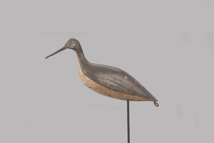
The Johnson Johnson Yellowlegs Decoy by J. Taylor Johnson (1853-1929)Copley Fine Art Auctions4.5(40)See Sold PriceFeb 24, 2024
LARGE EARLY 18TH C. DUTCH CHART OF UPPER NORTH AMERICA, PIERRE MORTIER (1661-1711), FRAMEDThomaston Place Auction Galleries4.4(389)See Sold PriceFeb 24, 2024
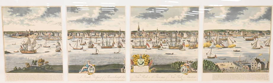
A South Prospect of Ye Flourishing City of New York in the Province of New York, North AmericaNadeau's Auction Gallery4.7(405)See Sold PriceFeb 24, 2024
America and the Great War for Humanity and Freedom 1917North American Artifact Auctions4.6(184)See Sold PriceApr 20, 2024
5 Hardback Books on Birds, Animals & Nature all in Excellent condition.North American Artifact Auctions4.6(184)See Sold PriceApr 20, 2024
Arrowsmith & Lewis - Map of North AmericaTrillium Antique Prints & Rare Books4.5(30)See Sold PriceFeb 24, 2024
Map: An 18thC engraved and hand coloured map of North America and South America, titled DeClaydon Auctioneers Ltd4.3(125)See Sold PriceFeb 26, 2024
1862 North America Anthony Trollope West Indies AND Spanish Main CANADA NIAGARAJasper524.5(9.8k)See Sold PriceFeb 27, 2024
New and Correct Map of North America With the West India Islands,Jasper524.5(9.8k)See Sold PriceFeb 27, 2024
Map of United States of North America, 1785Antiques Online Auctions4.6(410)See Sold PriceMar 14, 2024