Sold(ILLINOIS) COLTON, J. H. New Sectional Map of the(ILLINOIS) COLTON, J. H. New Sectional Map of the State of Illinois. Compiled from the United States Surveys. By J. M. Peck, John Messinger and A. J. Matthewson. Engraved by S. Stiles. New York: J. W.See Sold Price
Sold(CHICAGO, MAPS) COLTON, J. H. New Sectional Map of(CHICAGO, MAPS) COLTON, J. H. New Sectional Map of the State of Illinois. Compiled from the United States Surveys. Also exhibiting the Internal Improvements, distances between Towns Villages & Post OfSee Sold Price
J. H. COLTON & CO., PECK, J., MESSINGER, J., MATHEWSON,J. H. COLTON. New Sectional Map of the State of Illinois. Compiled From the United States Surveys. [New York, 1852]. Lithographed map with hand-coloring, image 1037 x 712 mm (sheet 1102 x 788 mm). PriSee Sold Price
SoldNew Sectional Map of the State of Illinois. CompiAuthor: Colton, J.H. Lithographed map, hand-colored. 98x62 cm. (38½24½") plus decorative border; folding into embossed leather covers lettered in gilt. Large, well-executed example of the Peck & MesSee Sold Price
New Sectional Map of the State of Illinois. CompiAuthor: Colton, J.H. Lithographed map, hand-colored. 98x62 cm. (38½24½") plus decorative border; folding into embossed leather covers lettered in gilt. Large, well-executed example of the Peck & MesSee Sold Price
SoldNew Sectional Map of the State of Illinois. CompiAuthor: Colton, J.H. Lithographed map, hand-colored. 98x62 cm. (38½24½") plus decorative border; folding into embossed cloth covers lettered in gilt. Large, well-executed example of the Peck & MessiSee Sold Price
SoldNew Sectional Map of the State of Illinois. CompiAuthor: Colton, J.H. Engraved map, hand-colored. 102.5x68.5 cm. (40¼x27"); folding into embossed red leather covers lettered in gilt, 5¾x3¾. Large, detailed, and brightly colored map of Illinois, aSee Sold Price
SoldColton's new sectional map of the state of Missouri;Colton's new sectional map of the state of Missouri; 1869 New York J.H. Colton. Thirty mile scaleDimensions: 29 1/2" X 34"Inv.30See Sold Price
SoldColton's Iowa Map [Midwestern States]Colton's Illinois Map. J. H. Colton Cartographer. Published by J. H. Colton, New York. Stamped 'Entered according to Act of Congress in the Year 1855 by J. H. Colton and Co. in in the Clerks Office ofSee Sold Price
[MAP] Colton’s Sectional Map of the State of Iowa. 1867267. [MAP]. COLTON, J.H, (copyright) & G.W. & C.B. Colton (publisher). Colton’s Sectional Map of the State of Iowa.... New York, 1867. Lithograph map on banknote paper, original full colSee Sold Price
Colton's Illinois Map [Midwestern States]Colton's Illinois Map. J. H. Colton Cartographer. Inset of 'Vicinity of Chicago' lower left. Published by J. H. Colton, New York. Stamped 'Entered according to Act of Congress in the Year 1855 by J. HSee Sold Price
SoldColton/Johnson State Maps [Various State Maps]Four Colton Maps - Illinois, Indiana, Iowa and New Hampshire. J. H. Colton Cartographer. Published by J. H. Colton, New York. Stamped 'Entered according to Act of Congress in the Year 1855 by J. H. CoSee Sold Price
Sold(MAP) COLTON, J. H. The City of Chicago Illinois(MAP) COLTON, J. H. The City of Chicago Illinois, 1855. The Plans of Chicago & St. Louis are Upon the Same Scale. New York: J. H. Colton, 1855. Full color engraved pocket map, trimmed from Colton's AtSee Sold Price
1861 Illinois. By JohnsonTitle: 1861 Illinois. By Johnson Date/Period: 1861 Materials: Steel engraved. Size: 18 x 13” 1861. By A. J. Johnson & J. H Colton. From "Johnson's New Illustrated Family Atlas' published in New YorkSee Sold Price
1861 Illinois. By JohnsonTitle: 1861 Illinois. By Johnson Date/Period: 1861 Materials: Steel engraved. Size: 18 x 13” 1861. By A. J. Johnson & J. H Colton. From "Johnson's New Illustrated Family Atlas' published in New YorkSee Sold Price
1861 Illinois. By JohnsonTitle: 1861 Illinois. By Johnson Date/Period: 1861 Materials: Steel engraved. Size: 18 x 13” 1861. By A. J. Johnson & J. H Colton. From "Johnson's New Illustrated Family Atlas' published in New YorkSee Sold Price
1861 Illinois. By JohnsonTitle: 1861 Illinois. By Johnson Date/Period: 1861 Materials: Steel engraved. Size: 18 x 13” 1861. By A. J. Johnson & J. H Colton. From "Johnson's New Illustrated Family Atlas' published in New YorkSee Sold Price
1861 Illinois. By JohnsonTitle: 1861 Illinois. By Johnson Date/Period: 1861 Materials: Steel engraved. Size: 18 x 13” 1861. By A. J. Johnson & J. H Colton. From "Johnson's New Illustrated Family Atlas' published in New YorkSee Sold Price
Illinois. By JohnsonTitle: Illinois. By Johnson Date/Period: 1861 Materials: Steel engraved. Size: 18 x 13” 1861. By A. J. Johnson & J. H Colton. From "Johnson's New Illustrated Family Atlas' published in New York. SteSee Sold Price
SoldColton's western tourtist. 1855SMITH, J. Calvin Guide through Ohio, Michigan, Indiana, Illinois, Missouri, Wisconsin & Iowa.New York: J. H. Colton, 1855. Hand-colored engraved folding pocket map (20 ½ x 26 inches, 520x660See Sold Price
SoldJ. Calvin Smith Guide Through Ohio... mapSmith, J. Calvin- ''Guide through Ohio, Michigan, Indiana, Illinois, Missouri, Wisconsin & Iowa'', New York: published by J. H. Colton, 1856, engraved map with hand-coloring folding pocket map. (red cSee Sold Price
Sold1855 Map of St. Louis and ChicagoA steel plate engraved dual city map of both St. Louis, Missouri and Chicago, Illinois as part of a single page in an atlas by JH Colton Company. Hand watercolored to add division among different partSee Sold Price
SoldColton Map of the Eastern Portion of NCColton’s 1863 Pocket Map of North CarolinaWith Outstanding Provenance-Property of a Union Human Shield 38. [MAP]. COLTON, J. H. Colton's New Topographical Map of the Eastern Portion of the StateSee Sold Price
Colton Map of VirginiaCOLTON, J. H. (1800-1893).Colton's New Topographical Map of the States of Virginia, Maryland and Delaware...Lithographed map with original hand color in full.New York: Colton, 1862.32 3/4" x 46 1/4" sSee Sold Price
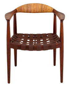
Hans Wegner for J. Hansen JH-501 Teak Arm ChairAuctions at Showplace4.6(731)See Sold PriceMar 03, 2024
19thc Colton Map, Comparitive Size of Lakes & IslandsConnoisseur Auctions3.9(335)See Sold PriceFeb 24, 2024
"THE MEANING OF SAINTHOOD" SERMON & ARRANGMENTSJohn McInnis Auctioneers,LLC4.6(504)See Sold PriceFeb 25, 2024
Vintage County Map Of NY State Plate EngravingThe Benefit Shop Foundation Inc.4.3(2.9k)See Sold PriceFeb 28, 2024
“Miss Cubas”. Group of Two CDVs of...Potter & Potter Auctions4.6(544)See Sold PriceMar 07, 2024
[BASEBALL]. [SHEET MUSIC]. KALBFLEISCH, J. H. The Live Oak ...Potter & Potter Auctions4.6(544)See Sold PriceMar 07, 2024
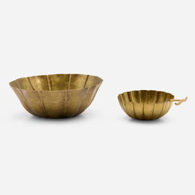
Josef Hoffmann, Floriform bowls, set of twoToomey & Co. Auctioneers4.7(391)See Sold PriceFeb 29, 2024
Two Hand-Colored 19th Century Maps of New Orleans and Louisiana, Larger- H.- 12 1/2 in., W.- 15 1/2Crescent City Auction Gallery4.3(231)See Sold PriceMar 08, 2024
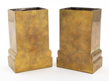
Josef Hoffmann Wiener Werkstatte Brass Vases, PairAuctions at Showplace4.6(731)See Sold PriceApr 07, 2024
Rare 19thc Colton Map, Argentine Republic, Chile, Uruguay, PataguayConnoisseur Auctions3.9(335)See Sold PriceMar 16, 2024
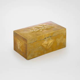
JOSEPH H. GREENWOOD (Massachusetts, 1857-1927), "The Clearing"., Oil on wooden cigar box top, 7" xEldred's4.7(418)See Sold PriceMar 14, 2024
Fotograf der 2. Hälfte des 20. Jh.: New YorkPeter Karbstein Kunst und Auktionshaus4.2(9)See Sold PriceMar 16, 2024


![Colton's Iowa Map [Midwestern States] (1 of 3)](https://p1.liveauctioneers.com/5755/154409/77936937_1_x.jpg?height=282&quality=70&version=1573094011)
![[MAP] Colton’s Sectional Map of the State of Iowa. 1867 (1 of 7)](https://p1.liveauctioneers.com/514/38480/16487138_1_x.jpg?height=282&quality=70&version=1363614971)
![Colton's Illinois Map [Midwestern States] (1 of 3)](https://p1.liveauctioneers.com/5755/154409/77936938_1_x.jpg?height=282&quality=70&version=1573094011)
![Colton/Johnson State Maps [Various State Maps] (1 of 14)](https://p1.liveauctioneers.com/5755/157962/79722067_1_x.jpg?height=282&quality=70&version=1576875253)


![[BASEBALL]. [SHEET MUSIC]. KALBFLEISCH, J. H. The Live Oak ... (1 of 5)](https://p1.liveauctioneers.com/928/318880/171361400_1_x.jpg?height=282&quality=70&version=1707501302)