ATLAS of ANTIENT GEOGRAPHY by SAMUEL BUTLER 1843John McInnis Auctioneers,LLC4.6(502)See Sold PriceFeb 24, 2024
18TH C. ANTIQUE MAP: FRENCH & INDIAN WAR, FRAMEDThomaston Place Auction Galleries4.4(386)See Sold PriceFeb 24, 2024
Rand McNally Railroad Map Cabinet w/ 21 Railroad MapsRail & Road Auctions4.6(165)See Sold PriceMar 08, 2024
Keith Haring - Ink on New York Map, Best Buddies, Inscribed, Signed, and DatedSapphire Auction Gallery4(67)See Sold PriceMar 02, 2024
LATE 17TH C. FRENCH MAP OF THE NEW WORLD BY ALEXIS-HUBERT JAILLOT (1632-1712)Thomaston Place Auction Galleries4.4(386)See Sold PriceFeb 24, 2024
Central Railroad of New Jersey Map of Sandy Hook Route-ca. 1903JM Hobby Supply and Railroad Artifact Auctions4.4(126)See Sold PriceFeb 24, 2024
Lot of Six Mixed Atlas Box Cars-HO Scale-New in BoxJM Hobby Supply and Railroad Artifact Auctions4.4(126)See Sold PriceFeb 25, 2024
Rand McNally/Santa Fe Railroad Map of Iowa-1912JM Hobby Supply and Railroad Artifact Auctions4.4(126)See Sold PriceFeb 24, 2024
NICOLAES VISSCHER (NETHERLANDS, 1618-1709) MAP OF THE NEW WORLDThomaston Place Auction Galleries4.4(386)See Sold PriceFeb 24, 2024
17TH C. WORLD MAP BY NICOLAES VISSCHER (NETHERLANDS, 1618-1709)Thomaston Place Auction Galleries4.4(386)See Sold PriceFeb 24, 2024
Lot of Six Mixed Atlas Cabooses-HO Scale-New in BoxJM Hobby Supply and Railroad Artifact Auctions4.4(126)See Sold PriceFeb 25, 2024
Sold1900 Map of the PhilippinesAuthor: Crowell Title: 1900 Map of the Philippines Medium: Ink on Paper Dimensions: 13.5"X22" Map of the Philippines dated 1900. Published by Crowell and Kirkpatrick in New York. Map is dated. DoubleSee Sold Price
1900 Map of the PhilippinesTitle: 1900 Map of the Philippines Author: Crowell Medium: Ink on Paper Dimensions: 13.5"X22" Description: Map of the Philippines dated 1900. Published by Crowell and Kirkpatrick in New York. Map is dSee Sold Price
SoldATLAS OF PHILIPPINE ISLANDS 1900 Color MapsWe at CNY Book Auctions are pleased to offer a variety of rare and scholarly titles concerning China, Japan, India, the Philippines, and other areas of Asia. Check out the rest of our catalog to viewSee Sold Price
SoldMAP, San Mateo, Philippines, Corps of Eng.San Mateo, Philippines. U.S. Corps of Engineers, Map of Battle Field of San Mateo. U.S. Forces Commanded by Lt. Col. So. So. Sargent..., 1900 (dated). Black & White. A detailed map showing U.S. militaSee Sold Price
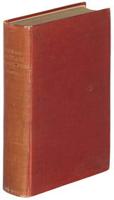
SoldSawyer on Inhabitants of the Philippines 1900Title: The Inhabitants of the Philippines Author: Sawyer, Frederic H. Description: xxviii, 422 pp. Numerous plates from photograph; folding map. 22x14 cm. (8¾x5½"), original red cloth lettered and pSee Sold Price
SoldHarper's History of the War in the PhilippinesHeading: (Philippines) Author: Wilcox, Marrion, editor Title: Harper's History of the War in the Philippines Place Published: New York & London Publisher:Harper & Brothers Date Published: 190See Sold Price
Sold1763 Seale Map Philippines Spice Islands & Celebes1763 Seale Map Of The Philippines Spice Islands And Celebes - The Philippin, Carolin, Molucka, And Spice Islands, R Seale, C. 1763, London, 18.5 x 13.4 in. A magnificent map of the Phillippines, easteSee Sold Price
Sold1900 Map of MontanaAuthor: Mast Title: 1900 Map of Montana Medium: Ink on Paper Dimensions: 13.5"X11" Map of Montana dated 1900. Published by Mast, Crowell and Kirkpatrick. Dated. Key lower left. Color coded for territoSee Sold Price
Sold1900 Map of CharlestonAuthor: Watson Title: 1900 Map of Charleston Medium: Ink on Paper Dimensions: 11.5"X14.5" Map of the city of Charleston dated 1900. Printed and published by Watson in Chicago. Part of his World Atlas.See Sold Price
1900 Map of DenverAuthor: Cram Title: 1900 Map of Denver Medium: Ink on Paper Dimensions: 14.5"X11.5" Map of the city of Denver dated 1900. Printed and published by George Cram in Chicago. Part of his World Atlas. ColoSee Sold Price
SoldLadle, around 1900 - Philippines - Ifugao, Hapao areawood, shiny, dark brown patina, oval bowl, handle in form of a standing human figure with open worked headgear, min. dam., slight traces of abrasion H: 43 cm, H: 16,9 inch Provenance: Maria Closa, ManSee Sold Price
SoldMilitary Telegraph Lines Map - Philippines - Asia - National Geographic 1950sTitle/Content: Military Telegraph Lines Map - Philippines - Asia - National Geographic 1950s Date: 1950s Material: Paper Dimensions: 35” x 34” inches / 90 cm x 86 cm (х2) 35” xSee Sold Price
Sold1900 Map of MontanaAuthor: Mast Title: 1900 Map of Montana Medium: Ink on Paper Dimensions: 13.5"X11" Description: Map of Montana dated 1900. Published by Mast, Crowell and Kirkpatrick. Dated. Key lower left. Color codeSee Sold Price
SoldUnusual c. 1900 Philippines Photo of ChildrenSee terms and conditions for shipping info.See Sold Price
Sold1900 Map of LouisvilleAuthor: Cram Title: 1900 Map of Louisville Medium: Ink on Paper Dimensions: 14.5"X11.5" Map of the city of Louisville dated 1900. Printed and published by George Cram in Chicago. Part of his World AtlSee Sold Price
Sold1900 Map of WisconsinTitle: 1900 Map of Wisconsin Author: Matthews Medium: Ink on Paper Dimensions: 13.5"X21.5" Description: Map of Wisconsin dated 1900. Published by the Matthews-Northrup Co. in Buffalo, New York. DoubleSee Sold Price
Sold1900 Map of ColoradoAuthor: Watson Title: 1900 Map of Colorado Medium: Ink on PaperDimensions: 13.5"X11" Map of Colorado dated 1900. Published by Watson in Chicago. Dated explanation on population, land and water surfaceSee Sold Price
1900 Map of MontanaAuthor: Cram Title: 1900 Map of Montana Medium: Ink on Paper Dimensions: 22"X15" Map of Montana dated 1900. Printed and published by George Cram in Chicago. Part of his Family Atlas. Double folio map.See Sold Price
1900 Map of New JerseyTitle: 1900 Map of New Jersey Author: Matthews Materials: Ink on Paper Dimensions: 10.5"X13.5" Description: Map of New Jersey dated 1900. Printed and published by Matthews and Northrup co. in Buffalo,See Sold Price
Sold1900 Map of AlaskaAuthor: Mast Title: 1900 Map of Alaska Medium: Ink on Paper Dimensions: 21.5"X13.5" Description: Map of Alaska and some parts of British America(present day Canada) dated 1900. Published by Mast, CrowSee Sold Price
INDOCHINA.Siam with British & French spheres. Burma Cambodia Anam 1900 mapTITLE/CONTENT OF MAP: 'Siam, Anam, Cambodia, Cochin China, Tong King' DATE PRINTED: 1900 IMAGE SIZE: Approx 28.5 x 21.0cm, 11 x 8.25 inches (Medium) TYPE: Antique colour map CONDITION: Good; suitableSee Sold Price
1900 Map of AlaskaTitle: 1900 Map of Alaska Author: Mast Medium: Ink on Paper Dimensions: 21.5"X13.5" Double folio map of Alaska and portion of Canada dated 1900. Published by Mast, Crower&Kirkpatrick. This double foliSee Sold Price
Sold1900 Map of ClevelandAuthor: Cram Title: 1900 Map of Cleveland Medium: Ink on paper Dimensions: 14.5"X11.5" Map of Cleveland dated 1900. Engraved and published by George Cram in Chicago. Part of Cram's Universal Atlas. VeSee Sold Price
ANDREW RAYMOND JANSON OIL ON BOARD ADIRONDACKSCharleston Estate Services Ltd.4.5(58)See Sold PriceMar 03, 2024
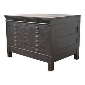
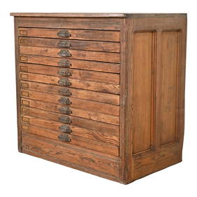
Antique Arts & Crafts Ebonized Oak Architect's Blueprint Flat File Cabinet, Circa 1900Liberty & 33rd Furniture Co.4.4(11)See Sold PriceFeb 27, 2024
Antique Pine 12-Drawer Blueprint Flat File Cabinet by Hamilton, Circa 1900Liberty & 33rd Furniture Co.4.4(11)See Sold PriceFeb 27, 2024
Antique Arts & Crafts Oak Architect's Blueprint Flat File Cabinet, Circa 1900Liberty & 33rd Furniture Co.4.4(11)See Sold PriceFeb 27, 2024
Colonial Africa. British German French Spanish Portuguese Italian TIMES 1900 mapJasper524.5(9.8k)See Sold PriceFeb 28, 2024
Colonial West Africa. Nigeria Cameroon Congo. British German. TIMES 1900 mapJasper524.5(9.8k)See Sold PriceFeb 28, 2024
Colonial Africa North-East. Hejaz Kenya Abyssinia Colonial. THE TIMES 1900 mapJasper524.5(9.8k)See Sold PriceFeb 28, 2024
COLONIAL AFRICA. British East/Central/South Africa. Bechuanaland 1900 old mapJasper524.5(9.8k)See Sold PriceFeb 28, 2024
Colonial Southern Africa. British Portuguese German. Madagascar. TIMES 1900 mapJasper524.5(9.8k)See Sold PriceFeb 28, 2024
Colonial Africa North-West. British French. Nigeria Sahara. THE TIMES 1900 mapJasper524.5(9.8k)See Sold PriceFeb 28, 2024