Sold1812 Cadell and Davies Map of Eastern Mediterranean andTitle: 1812 Cadell and Davies Map of Eastern Mediterranean and Black Sea Regions -- Italia Gracia Asia &c. Cartographer: Cadell and Davies Year / Place: 1812, London Map Dimension (in.): 7.8 X 9.9 in.See Sold Price
1812 Cadell and Davies Map of Eastern Mediterranean andTitle/Content of Map: 1812 Cadell and Davies Map of Eastern Mediterranean and Black Sea Regions -- Italia Gracia Asia &c. Cartographer: Cadell and Davies Year/Place: 1812, London Size: 7.8 X 9.9 in. TSee Sold Price
1812 Cadell and Davies Map of Eastern Mediterranean andTitle: 1812 Cadell and Davies Map of Eastern Mediterranean and Black Sea Regions -- Italia Gracia Asia &c. Cartographer: Cadell and Davies Year/Place: 1812, London Dimensions: 7.8 X 9.9 in. DescriptioSee Sold Price
1812 Cadell and Davies Map of Eastern Mediterranean andTitle/Content of Map: 1812 Cadell and Davies Map of Eastern Mediterranean and Black Sea Regions -- Italia Gracia Asia &c. Cartographer: Cadell and Davies Year/Place: 1812, London Size: 7.8 X 9.9 in. TSee Sold Price
Framed Map of AsiaMap of Asia; Framed. Published Jan,1,1812 by Cadell & Davies Strand. Image: 9 1/4" x 7 3/4" Frame: 14 3/4" 13 3/8" Property from private collector, NJSee Sold Price
SoldHerbert Map of Scotland 1812Herbert, L. (fl. 1810-1825). Scotland Northern Part / Scotland Southern Part. Engraved map. Cadell & Davies; Longman, Hurst, Rees, Orme & Brown, 1812. 42" x 28" sheet. From Pinkerton's Modern Atlas. VSee Sold Price
SoldHANDCOLORED ENGRAVED MAP, EASTERN MEDITERRANEANHANDCOLORED ENGRAVED MAP, EASTERN MEDITERRANEAN/AFRICA M. HEBERERS, 18/19TH CENTURY. 9 X 12"; FRAMED & GLAZED 15 X 18"See Sold Price
1662 Geographia Sacra Tabula Prima, Map of Eastern Mediterranean & Middle East17th century. Geographiae Sacrae ex Veteri, et Novo Testamento Desumptae Tabula Prima, quae Totius Orbis Partes Continet. Published in Cartes Generales de Toutes les Parties du Monde, attributed toSee Sold Price
SoldLot of Three German Maps, Lot of Three German Maps, used by Luftwaffe for charting and bombing, all are vinyl to be waterproof. First is map of eastern Mediterranean and southern Black Sea. Two-sided map with one side topogrSee Sold Price
Eastern Mediterranean & Black Sea chart. Ports lighthouses mail. LARGE 1959 mapTITLE/CONTENT OF MAP: 'The Eastern Mediterranean inset Brindisi; Valetta; Thessaloniki; Odessa; The Sea of Azov; Corinth Canal; Istanbul and the Bosphorus; Izmir; Piraeus; Alexandria' DATE PRINTED: 19See Sold Price
Eastern Mediterranean & Black Sea chart. Ports lighthouses mail. LARGE 1927 mapTITLE/CONTENT OF MAP: The Eastern Mediterranean [inset Brindisi; Valetta; Salonika; Odessa; The Sea of Azov; Corinth Canal; Bosporus; Piraeus & Athens; Smyrna; Alexandria; Suez Canal] DATE PRINTED: 19See Sold Price
Eastern Mediterranean & Black Sea chart. Ports lighthouses mail. LARGE 1918 mapTITLE/CONTENT OF MAP: 'The Eastern Mediterranean; Inset Salonica; Odessa; Corinth Canal; The Sea of Azof; Bosphorus; Piraeus & Athens; Suez Canal; Smyrna; Alexandria; Brindisi; Valetta' DATE PRINTED:See Sold Price
Turquie Européenne. Turkey in Europe. Balkans Greece Aegean. VAUGONDY 1755 mapTITLE/CONTENT OF MAP: The Eastern Mediterranean [inset Brindisi; Valetta; Salonika; Odessa; The Sea of Azov; Corinth Canal; Bosporus; Piraeus & Athens; Smyrna; Alexandria; Suez Canal] DATE PRINTED: 19See Sold Price
Eastern Mediterranean & Black Sea chart. Ports lighthouses mail. LARGE 1959 mapTITLE/CONTENT OF MAP: 'The Eastern Mediterranean inset Brindisi; Valetta; Thessaloniki; Odessa; The Sea of Azov; Corinth Canal; Istanbul and the Bosphorus; Izmir; Piraeus; Alexandria' DATE PRINTED: 19See Sold Price
Eastern Mediterranean & Black Sea chart. Ports lighthouses mail. LARGE 1918 mapTITLE/CONTENT OF MAP: 'The Eastern Mediterranean; Inset Salonica; Odessa; Corinth Canal; The Sea of Azof; Bosphorus; Piraeus & Athens; Suez Canal; Smyrna; Alexandria; Brindisi; Valetta' DATE PRINTED:See Sold Price
SoldJansson's map of the Eastern Mediterranean SeaJan Jansson, "Paascaarte van't Oostelyckste deel van de Middelandsche Zee (Amsterdam: 1652) Engraving with old hand coloring, 21 1/2 X 16 1/2, p.m.; Property from the Hans Goedicke EstateSee Sold Price
SoldJansson's map of the Eastern Mediterranean SeaJan Jansson, "Paascaarte van't Oostelyckste deel van de Middelandsche Zee (Amsterdam: 1652) Engraving with old hand coloring, 21 1/2 X 16 1/2, p.m.Property from the Hans Goedicke EstateSee Sold Price
SoldMap of the Eastern Mediterranean and Black Sea Areas byCopper plate, hand-colored engraved map titled "Carte Genrerale Pour L'Intelligence De L'Histoire Profane Du Quatrieme Age." by Claude Buy De Mornas. Map was published for the Atlas Historique et GeogSee Sold Price
Map of the Eastern Mediterranean Basin. Nicolas Sanson.Geographiae Sacrae ex Veteri et Novo Testamento desumptae Tabula Prima quae Totius Orbis Partes continent. The Eastern Mediterranean Basin and the Near East. Copperplate engraving. Black and white. BySee Sold Price
SoldAeneae Navigatio.[Mediterranean/Balkans]. Aeneae Navigatio. Folding map of the eastern Mediterranean region (Balkan Peninsula, southern Asia Minor, Italian Peninsula, and eastern portion of Africa’s northern coast),See Sold Price
SoldOribs Romani Pars Orientalis. 1794.[Ancient Geography/Mediterranean]. Oribs Romani Pars Orientalis. Double-page map of the eastern Mediterranean and Black Seas regions, from the 1764 by Jean Baptiste D’Anville. Lon: Laurie & Whittle,See Sold Price
SoldPETIT, PIERRE. De Amazonibus dissertatio. 168PETIT, PIERRE. De Amazonibus dissertatio. Text illustrations, mostly of numismatic subjects; folding engraved map of the eastern Mediterranean and Asia Minor. [12], 398, [12] pages, including engravedSee Sold Price
Oribs Romni Pars Orientalis. Lon: 1794.[Middle East/Southeastern Europe]. Oribs Romani Pars Orientalis. Double-page map of the eastern Mediterranean and Black Seas regions, from the 1764 by Jean Baptiste D’Anville. Lon: Laurie & Whittle,See Sold Price
1810 c. Didot Map of Central-Eastern Mediterranean SeaTitle: 1810 c. Didot Map of Central-Eastern Mediterranean Sea Region -- Carte des Etats de la repiblique de Venise Cartographer: P Didot Year / Place: 1810 c., Paris Map Dimension (in.): 8.3 X 11.5 inSee Sold Price
Eastern RR Summer Book of Tours-1884JM Hobby Supply and Railroad Artifact Auctions4.4(127)See Sold PriceFeb 24, 2024
Boston and Albany RR March 17, 1881 Public TimetableJM Hobby Supply and Railroad Artifact Auctions4.4(127)See Sold PriceFeb 24, 2024
19thc Colton Map, Comparitive Size of Lakes & IslandsConnoisseur Auctions3.9(336)See Sold PriceFeb 24, 2024
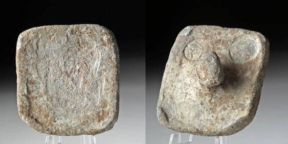
Large Late Roman Sigma-Shaped Marble Offering Table TopTimeLine Auctions Ltd.4.6(183)See Sold PriceMar 05, 2024
De Jode, Rare, pub. 1593 - Map of the Middle East, Eastern Asia (Primae Partis Asiae accurataTrillium Antique Prints & Rare Books4.5(32)See Sold PriceFeb 24, 2024
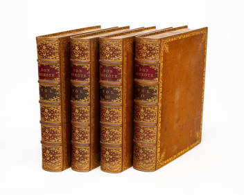
FOUR-VOLUME LEATHER-BOUND BOOK SET DON QUIXOTE 1818.Amelia Jeffers, Auctioneers & Appraisers4.5(120)See Sold PriceMar 08, 2024
VARIOUS ARTISTS [BRITISH TRAVEL GUIDES]. Group of 6 map booklets and flyers. 1930s.Swann Auction Galleries4.4(70)See Sold PriceFeb 29, 2024
1764 Bellin Map of Eastern Guadeloupe in the Lesser Antilles -- Partie Orientale de l'Isle de laJasper524.5(9.9k)See Sold PriceFeb 27, 2024
NORTH & WEST AFRICA. Sahara Niger river 'Zaara ou le Desert'. MALLET 1683 mapJasper524.5(9.9k)See Sold PriceFeb 28, 2024
West Africa by Arrowsmith & Lewis 1812 old antique vintage map plan chartJasper524.5(9.9k)See Sold PriceFeb 28, 2024
SUB-SAHARAN AFRICA. 'Ancienne Ethiopie'. Ancient Ethiopia. MALLET 1683 old mapJasper524.5(9.9k)See Sold PriceFeb 28, 2024
Africa by Arrowsmith & Lewis 1812 old antique vintage map plan chartJasper524.5(9.9k)See Sold PriceFeb 28, 2024
5th C. Byzantine Lead Ingot Weight w/ Inspection StampsArtemis Fine Arts4.8(1.4k)See Sold PriceFeb 26, 2024
Guthrie, William 1812 Antique Map. Spain and PortugalAlbion Auctions4.6(341)See Sold PriceMar 01, 2024
ANTIQUE ILLUSTRATED HANDBOOK OF GEOGRAPHY AND TRAVEL IN ASIA, VOLUME 2, 1896NY Elizabeth 4.2(86)See Sold PriceMar 03, 2024


![VARIOUS ARTISTS [BRITISH TRAVEL GUIDES]. Group of 6 map booklets and flyers. 1930s. (1 of 2)](https://p1.liveauctioneers.com/199/319703/171640571_1_x.jpg?height=282&quality=70&version=1707943705)