ATLAS of ANTIENT GEOGRAPHY by SAMUEL BUTLER 1843John McInnis Auctioneers,LLC4.6(502)See Sold PriceFeb 24, 2024
18TH C. ANTIQUE MAP: FRENCH & INDIAN WAR, FRAMEDThomaston Place Auction Galleries4.4(386)See Sold PriceFeb 24, 2024
Rand McNally Railroad Map Cabinet w/ 21 Railroad MapsRail & Road Auctions4.6(165)See Sold PriceMar 08, 2024
Keith Haring - Ink on New York Map, Best Buddies, Inscribed, Signed, and DatedSapphire Auction Gallery4(67)See Sold PriceMar 02, 2024
LATE 17TH C. FRENCH MAP OF THE NEW WORLD BY ALEXIS-HUBERT JAILLOT (1632-1712)Thomaston Place Auction Galleries4.4(386)See Sold PriceFeb 24, 2024
Central Railroad of New Jersey Map of Sandy Hook Route-ca. 1903JM Hobby Supply and Railroad Artifact Auctions4.4(126)See Sold PriceFeb 24, 2024
Lot of Six Mixed Atlas Box Cars-HO Scale-New in BoxJM Hobby Supply and Railroad Artifact Auctions4.4(126)See Sold PriceFeb 25, 2024
Rand McNally/Santa Fe Railroad Map of Iowa-1912JM Hobby Supply and Railroad Artifact Auctions4.4(126)See Sold PriceFeb 24, 2024
NICOLAES VISSCHER (NETHERLANDS, 1618-1709) MAP OF THE NEW WORLDThomaston Place Auction Galleries4.4(386)See Sold PriceFeb 24, 2024
17TH C. WORLD MAP BY NICOLAES VISSCHER (NETHERLANDS, 1618-1709)Thomaston Place Auction Galleries4.4(386)See Sold PriceFeb 24, 2024
Lot of Six Mixed Atlas Cabooses-HO Scale-New in BoxJM Hobby Supply and Railroad Artifact Auctions4.4(126)See Sold PriceFeb 25, 2024
SoldJohnson's Delaware and Maryland 1866 MapJohnson's Delaware and Maryland Hand Colored Map. 1866. A.J. Johnson, New York. Map measures 12.75 x 15.75'' and is on loose paper measuring 14x18''. Hinge mounted to mat. Some scattered foxing and toSee Sold Price
1866 Johnson's Virginia, Delaware, Maryland & West VirginiaTitle: 1866 Johnson's Virginia, Delaware, Maryland & West Virginia Cartographer: Johnson & Ward Year / Place: 1866, New York Map Dimension (in.): 17 X 23 in. This is a superb, double page map of theseSee Sold Price
A. J. Johnson, "Delaware and Maryland," 1866, handA. J. Johnson, "Delaware and Maryland," 1866, hand colored, H.- 14 in., W.- 18 in.See Sold Price
SoldJOHNSON'S WASHINGTON AND GEORGETOWN MAPJOHNSON'S WASHINGTON AND GEORGETOWN MAP, hand-colored lithograph, dated 1868. Housed in a modern frame. Together with Johnson's Delaware and Maryland map, having Washington, DC street map inset and piSee Sold Price
SoldJohnson & Ward, Delaware and Maryland map[Maryland & Delaware]. Johnson and Ward. Johnson's Delaware And Maryland. Lithograph map, hand-colored, with inset of District of Columbia (uncolored), and 3 vignettes at top (Post Office, Treasury, aSee Sold Price
SoldMAP: Johnsons Delaware and Maryland, c. 1861Maps“Johnson’s Delaware and Maryland” Issued Circa 1861 c. 1861, “Johnson’s Delaware and Maryland,” published by Johnson and Ward, New York, Choice Extremely Fine.See Sold Price
SoldTwo Antique Maps, Two Western Prints, Seven SatiricalTwo Antique Maps, Two Western Prints, Seven Satirical English Hunting Printsas follows: two maps, Johnson's Virginia, Delaware, Maryland & West Virginia (New York, 1864) (18 x 26 in.), Map of MontanaSee Sold Price
SoldCivil War Era Map, Johnson's Virginia, Delaware,Civil War Era Map, Johnson's Virginia, Delaware, Maryland & West Virginia(New York: A. J. Johnson, 1864), steel engraving with color, this being one of the earlier maps showing the new state of West VSee Sold Price
SoldJohnson: Antique Map of Maryland & Delaware, 1863Title/Content of Map: 1863 Johnson Map of Maryland and Delaware -- Johnson's Delaware and Maryland Date Printed: 1863, New York Cartographer: A Johnson Size: 12.5 x 15.8 in. A very nice map of these tSee Sold Price
SoldJohnson: Antique Map of Delaware & Maryland, 1864Title/Content of Map: 1864 Johnson Map of Delaware and Maryland -- Johnson's Deleware and Maryland Date Printed: 1864 New York Cartographer: Johnson & Ward Size: 12.5 x 15.75 in. Condition: Very Good.See Sold Price
Sold1867 Johnson Map of Delaware and Maryland -- Johnson'sTitle: 1867 Johnson Map of Delaware and Maryland -- Johnson's Delaware and Maryland Cartographer: A Johnson Year / Place: 1867, New York Map Dimension (in.): 12.5 x 15.8 in. This is a very nice map ofSee Sold Price
1867 Johnson Map of Delaware and Maryland -- Johnson'sReserve Reduced! Map Title/Content: 1867 Johnson Map of Delaware and Maryland -- Johnson's Delaware and Maryland Cartographer: A Johnson Year / Place: 1867, New York Map Dimension (in.): 12.5 x 15.8 iSee Sold Price
SoldSix maps by AJ Johnson 1850sTitle: Johnson's maps - six maps Author: Johnson, A.J. Description: Includes: Delaware and Maryland. 1-page map. N.d. [c.1860]. * World on Mercators Projection. 2-page map. 1865. * California, Also UtSee Sold Price
SoldJohnson's Delaware & Maryland, 1861Map: Johnson's Delaware and Maryland Cartographer: Johnson & Browning Publishing: New York, 1861 Size: 12.3 x 16.3 inches A highly detailed map with topographical, city / town, and rail road details.See Sold Price
SoldDelaware & Maryland MapDelaware and Maryland, 17 x 14.5 in, 1860, Johnson & Browning Please note that this lot has a confidential reserve. When you leave a bid in advance of the auction, submit your maximum. Jasper52 will bSee Sold Price
SoldJohnson's Delaware and MarylandMap: Johnson's Delaware and Maryland Description: A map of these two mid-Atlantic states with plenty of topographical and settlement details as well as showing roads and railroads. Counties are colorSee Sold Price
SoldTwo Maps by Johnson & Ward, "Delaware and Maryland,"Two Maps by Johnson & Ward, "Delaware and Maryland," 1862, hand colored, H.- 13 1/2in., W.- 17 1/4 in.; together with "Map of the Vicinity of Richmond and Peninsular Campaign in Virginia," 1862, handSee Sold Price
SoldMaps of MD, DE, VA & D.C. Mid 19th century.A group of maps of Maryland, Delaware, Virginia and Washington D.C. ++ A Johnson & Ward map of Delaware and Maryland. 1864/New York. Maker: Alvin J. Johnson & H.C. Ward. Including vignettes of the PosSee Sold Price
Johnson: Antique Map of Maryland and Delaware, 1863Title/Content of Map: 1863 Johnson Map of Maryland and Delaware Date Printed: 1863, New York Cartographer: A Johnson Size: 12.5 x 15.8 in. A very nice map of these two mid-Atlantic states with plentySee Sold Price
Johnson: Antique Map of Maryland and Delaware, 1863Title/Content of Map: 1863 Johnson Map of Maryland and Delaware Date Printed: 1863, New York Cartographer: A Johnson Size: 12.5 x 15.8 in. A very nice map of these two mid-Atlantic states with plentySee Sold Price
Johnson: Antique Map of Maryland and Delaware, 1863Title/Content of Map: 1863 Johnson Map of Maryland and Delaware Date Printed: 1863, New York Cartographer: A Johnson Size: 12.5 x 15.8 in. A very nice map of these two mid-Atlantic states with plentySee Sold Price
1861 Delaware and Maryland, Johnson & BrowningReserve Reduced! Very clean and excellent map of Maryland and Delaware dating to 1861 by A. J. Johnson. This is the most decorative example of Johnson's Maryland - Delaware series. Along the top of thSee Sold Price
Sold1861 Delaware and Maryland, Johnson & BrowningVery clean and excellent map of Maryland and Delaware dating to 1861 by A. J. Johnson. This is the most decorative example of Johnson's Maryland - Delaware series. Along the top of the map are three eSee Sold Price
Sold1861 Penn., Va., Del., Md. - Johnson & BrowningNice first edition example of A. J. Johnson's 1861 map of Virginia, Maryland, Delaware and Pennsylvania. Offers a fascinating glimpse of these north-south borderlands shortly following the outbreak ofSee Sold Price
Delaware and Hudson RR International Holidays Book-1912JM Hobby Supply and Railroad Artifact Auctions4.4(126)See Sold PriceFeb 24, 2024
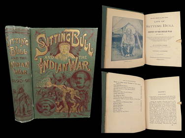
1891 Sitting Bull 1st ed Life Native American Sioux Indians DAKOTA Ghost DanceSchilb Antiquarian Rare Books4.8(421)See Sold PriceMar 10, 2024
Erik William Johnsen (Danish,1866-1948) oil painting antiqueBroward Auction Gallery4.8(277)See Sold PriceApr 14, 2024
1872 Holy BIBLE & Hitchcock Analysis Gruden Concordance Theology MAPS Holy LandSchilb Antiquarian Rare Books4.8(421)See Sold PriceMar 31, 2024
Pair of Early Railroad Maps - 1874 Delaware, Lackawanna & Western and 1876 Pennsylvania RailroadRail & Road Auctions4.6(165)See Sold PriceMar 07, 2024
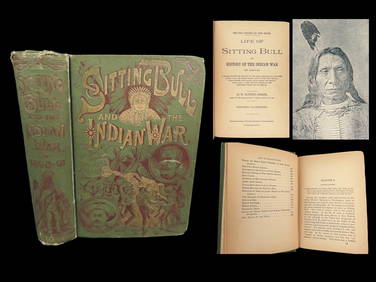
1891 DAKOTA Indians 1st ed Life Sitting Bull Native American Sioux Ghost DanceSchilb Antiquarian Rare Books4.8(421)See Sold PriceMar 31, 2024
Three Delaware & Hudson Canal Company Railroad Annual Passes - 1884, 1885, and 1886Rail & Road Auctions4.6(165)See Sold PriceMar 08, 2024
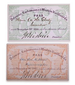
1866 and 1867 Delaware, Lackawanna & Western Railroad Annual PassesRail & Road Auctions4.6(165)See Sold PriceMar 08, 2024
Charlie Joiner (American, 1921-2015), Chestertown MD Mallard Duck Decoys, Drake and HenHoch LTD.4.5(73)See Sold PriceFeb 25, 2024
Carey, pub. 1796 - Map of the State of MarylandTrillium Antique Prints & Rare Books4.5(30)See Sold PriceFeb 24, 2024
Lot of 12 Vintage 1953 & 1954 General Mills Promotional Tin License PlatesBodnar's Auction Sales4.6(609)See Sold PriceMar 28, 2024
Johnson's Africa. Colonies & tribes. Liberia Nile Delta Cape Colony 1866 mapJasper524.5(9.8k)See Sold PriceFeb 28, 2024
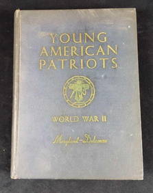
Vintage Young American Patriots World War IIRapid Estate Liquidators and Auction Gallery4.5(1.1k)See Sold PriceFeb 24, 2024
SIX DAYS IN 1866: THE COMPLETE STORY OF THE GREATEST LOSS OF AN ANTIQUE BRITISH SHIPWRECKNY Elizabeth 4.3(84)See Sold PriceMar 03, 2024