ATLAS of ANTIENT GEOGRAPHY by SAMUEL BUTLER 1843John McInnis Auctioneers,LLC4.6(502)See Sold PriceFeb 24, 2024
18TH C. ANTIQUE MAP: FRENCH & INDIAN WAR, FRAMEDThomaston Place Auction Galleries4.4(386)See Sold PriceFeb 24, 2024
Rand McNally Railroad Map Cabinet w/ 21 Railroad MapsRail & Road Auctions4.6(165)See Sold PriceMar 08, 2024
Keith Haring - Ink on New York Map, Best Buddies, Inscribed, Signed, and DatedSapphire Auction Gallery4(67)See Sold PriceMar 02, 2024
LATE 17TH C. FRENCH MAP OF THE NEW WORLD BY ALEXIS-HUBERT JAILLOT (1632-1712)Thomaston Place Auction Galleries4.4(386)See Sold PriceFeb 24, 2024
Central Railroad of New Jersey Map of Sandy Hook Route-ca. 1903JM Hobby Supply and Railroad Artifact Auctions4.4(126)See Sold PriceFeb 24, 2024
Lot of Six Mixed Atlas Box Cars-HO Scale-New in BoxJM Hobby Supply and Railroad Artifact Auctions4.4(126)See Sold PriceFeb 25, 2024
Rand McNally/Santa Fe Railroad Map of Iowa-1912JM Hobby Supply and Railroad Artifact Auctions4.4(126)See Sold PriceFeb 24, 2024
NICOLAES VISSCHER (NETHERLANDS, 1618-1709) MAP OF THE NEW WORLDThomaston Place Auction Galleries4.4(386)See Sold PriceFeb 24, 2024
17TH C. WORLD MAP BY NICOLAES VISSCHER (NETHERLANDS, 1618-1709)Thomaston Place Auction Galleries4.4(386)See Sold PriceFeb 24, 2024
Lot of Six Mixed Atlas Cabooses-HO Scale-New in BoxJM Hobby Supply and Railroad Artifact Auctions4.4(126)See Sold PriceFeb 25, 2024
SoldROLLING STONES collection of memorabiliaRolling Stones - a very large collection of original and reproduction posters, memoSee Sold Price
SoldSanta Fe RR System Map [126910]Atchison, Topeka, and Santa Fe Railway System map, professionally mounted, glazed, and framed. Finished size is approx. 38 x 20 inches. Shows routes from California to Louisiana and Kansas to Texas. VSee Sold Price
Large Framed 1846 Map of FloridaLarge Framed 1846 Map of Florida; a reprint of the original, matted, glazed, and mounted in a wood frame. This map shows the state when central Florida was one large county aptly named Mosquito. We arSee Sold Price
SoldLarge Framed 1846 Map of FloridaLarge Framed 1846 Map of Florida; a reprint of the original, matted, glazed, and mounted in a wood frame. This map shows the state when central Florida was one large county aptly named Mosquito. We arSee Sold Price
SoldA collection of framed maps Four maps, comprisingA collection of framed maps Four maps, comprising Marian, Matthaus Magnae Britanniae et Hiberniae Tabula, [Frankfurt, 1636], 28 x 36cm, hand coloured, framed and glazed; Out Amsterdam Gelyck het GewesSee Sold Price
SoldBlaeu, Jan A collection of mapsBlaeu, Jan A collection of maps Provincae Lauden seu Lothien et Linlitouo, 38 x 54cm, hand coloured, framed and glazed, some browning; Annandiae, 45 x 53cm, hand coloured, framed and glazed; Nithia ViSee Sold Price
SoldLarge 1852 Framed Map of the Town of Litchfield CTwith vignettes of famous properties framed and glazed 43x52 JFAH7176 TCSee Sold Price
SoldNicolas Bellin (French, fl. circa 1740-1802)Nicolas Bellin (French, fl. circa 1740-1802) large oblong hand-colored engraved world map, 1748, 21-1/2" x 30", litho-signed in the plate. Presented in a narrow fruitwood framed and glazed.See Sold Price
SoldIncredible Collection of Super Bowl Memorabilia,Incredible Collection of Super Bowl Memorabilia, Tickets from Super Bowl I (1967) through XXXVIII (2004); this is a large framed piece, double matted and glazed. The top matte is cut to frame each ticSee Sold Price
SoldLarge Continental northern world Celestial mapLarge Continental northern world Celestial map, 20th c., print on paper, 72.5"h x 68"w (sight), matted and framed under glass Provenance: Ford Foundation Collection - The Ford Foundation, establishedSee Sold Price
SoldLarge framed map, "New York City North of 93rd Street",Large framed map, "New York City North of 93rd Street", Colton's New Map of the City and County of New York Including Extensions North of the Harlem River, published by G.W. and C.B. Colton & Co.'s sSee Sold Price
SoldLarge Framed Map of Charleston HarborLarge framed map of Charleston Harbor. Approx. 36 inches x 50 inches. Overall good condition.See Sold Price
SoldEARLY FRAMED & GLAZED MAP OF CARIBBEANFRENCH PARM. RIZZI ZANNONI PARIS, 12" X 17 3/4"See Sold Price
SoldON 2, LARGE FRAMED MAP, INDIAN RESERVATIONS HON.HIRAM PRICE, 1884, PHOTO LITHOGRAPH, BELL BROS, WASHINGTON TOGETHER WITH PHOTO OF CHIEFS, MAP 21" X 33" SIGHT, PHOTO 7 1/2" X 9" SIGHT.See Sold Price
SoldLarge Framed Map of London, 1861Depicts London from the South Side of the Thames, this was a fold-out supplement to the illustrated London News, February 9, 1861, Rob Loudon Sr. Folds, creases, water stains in areas. Overall size: 2See Sold Price
SoldFRAMED & GLAZED MAP DEPICTING SWANSEA & SOMERSETMASS, INCLUDING POTTERSVILLE, 15 1/2" X 23 1/2" SIGHTSee Sold Price
SoldLarge framed mapLarge framed and matted hand colored map of North America by "A. Walker" and engraved by "R.W. Seale". Sight 32.5" x 34.25"See Sold Price
SoldRaul Coronel Tile PlaqueLarge framed glazed stoneware tile plaque by Raul Coronel, 1960s. 42" H x 38" W.See Sold Price
Sold19TH C. MAP OF PARIS19TH C. MAP OF PARIS: Large framed map of Paris Circa Mid 1900's by Malte-Brun family, in frame. Approx. 35" h x 43" w.See Sold Price
SoldMap, Suffolk Co. L. I.Large framed map from actual surveys, by John Douglass and J. Chance Jr. 517, 519, 521 Minor St., Philadelphia. 60" x 49". Worn condition.See Sold Price
LARGE GULF SERVICE STATION MAP COLLECTION WITH DISPLAY STAND.Dan Morphy Auctions4.2(1.3k)See Sold PriceFeb 24, 2024
Auguste Marie Raffet French 1804-1860 Watercolor painting Middle Eastern MenGlobal Auctions Company4.3(36)See Sold PriceMar 03, 2024
Eleanore Berman (1928-2004), Gouache on paper painting of Starling Bird, SignedGlobal Auctions Company4.3(36)See Sold PriceMar 03, 2024
Pair of Early Railroad Maps - 1862 Pittsburgh, Ft. Wayne & Chicago Railway and 1873 PennsylvaniaRail & Road Auctions4.6(165)See Sold PriceMar 07, 2024
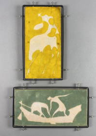
2 Midcentury Modern Glazed Clay Pottery TilesEpic Auctions and Estate Sales4.6(204)See Sold PriceMar 02, 2024
Hand Colored Map of the city of Amsterdam 1720Global Auctions Company4.3(36)See Sold PriceMar 03, 2024
1867 Map of the Railroads of The State of New YorkRail & Road Auctions4.6(165)See Sold PriceMar 08, 2024
17th Century Hand Colored Engraved Map of GermanyGlobal Auctions Company4.3(36)See Sold PriceMar 03, 2024
18th Century Hess Germany Hand colored Engraved MapGlobal Auctions Company4.3(36)See Sold PriceMar 03, 2024
A MAP OF THE STRAND OF THE NORTH SIDE OF CHANNEL OF RIVER ANNA LIFFE, 1811 Engraving, 680 x 480mmAdam's Auctioneers4.3(5)See Sold PriceFeb 27, 2024
Map of St. Kitts and Nevis Depot de la Marine, Paris, 1758Global Auctions Company4.3(36)See Sold PriceMar 03, 2024
Vintage Framed French Faience Polychrome Tiles, The SeasonsHoch LTD.4.5(73)See Sold PriceFeb 25, 2024
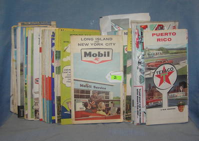
Collection of vintage auto related travel mapsBaker's Antiques and Auctions3.3(462)See Sold PriceFeb 25, 2024
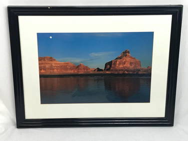
Large Framed Print of Horseshoe Bend in Marble Canyon, Colorado River, by Gary LaddRapid Estate Liquidators and Auction Gallery4.5(1.1k)See Sold PriceFeb 25, 2024
Framed Large Photograph of Lake Powell Glen Canyon Recreation AreaRapid Estate Liquidators and Auction Gallery4.5(1.1k)See Sold PriceFeb 26, 2024
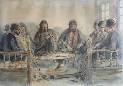
Sri Lankan Dancers ArtRapid Estate Liquidators and Auction Gallery4.5(1.1k)See Sold PriceFeb 27, 2024
Framed Collection Engravings & A Map From The Excursions In The County Of Sussex Published In 1822Rapid Estate Liquidators and Auction Gallery4.5(1.1k)See Sold PriceMar 01, 2024


![Santa Fe RR System Map [126910] (1 of 1)](https://p1.liveauctioneers.com/2699/193399/97512503_1_x.jpg?height=282&quality=70&version=1612301936)