ATLAS of ANTIENT GEOGRAPHY by SAMUEL BUTLER 1843John McInnis Auctioneers,LLC4.5(494)See Sold PriceFeb 24, 2024
18TH C. ANTIQUE MAP: FRENCH & INDIAN WAR, FRAMEDThomaston Place Auction Galleries4.4(386)See Sold PriceFeb 24, 2024
Rand McNally Railroad Map Cabinet w/ 21 Railroad MapsRail & Road Auctions4.6(165)See Sold PriceMar 08, 2024
Keith Haring - Ink on New York Map, Best Buddies, Inscribed, Signed, and DatedSapphire Auction Gallery3.9(67)See Sold PriceMar 02, 2024
LATE 17TH C. FRENCH MAP OF THE NEW WORLD BY ALEXIS-HUBERT JAILLOT (1632-1712)Thomaston Place Auction Galleries4.4(386)See Sold PriceFeb 24, 2024
Central Railroad of New Jersey Map of Sandy Hook Route-ca. 1903JM Hobby Supply and Railroad Artifact Auctions4.4(126)See Sold PriceFeb 24, 2024
Lot of Six Mixed Atlas Box Cars-HO Scale-New in BoxJM Hobby Supply and Railroad Artifact Auctions4.4(126)See Sold PriceFeb 25, 2024
Rand McNally/Santa Fe Railroad Map of Iowa-1912JM Hobby Supply and Railroad Artifact Auctions4.4(126)See Sold PriceFeb 24, 2024
NICOLAES VISSCHER (NETHERLANDS, 1618-1709) MAP OF THE NEW WORLDThomaston Place Auction Galleries4.4(386)See Sold PriceFeb 24, 2024
17TH C. WORLD MAP BY NICOLAES VISSCHER (NETHERLANDS, 1618-1709)Thomaston Place Auction Galleries4.4(386)See Sold PriceFeb 24, 2024
Lot of Six Mixed Atlas Cabooses-HO Scale-New in BoxJM Hobby Supply and Railroad Artifact Auctions4.4(126)See Sold PriceFeb 25, 2024
SoldSmith's Geography with colored maps, 1848Heading: (School Atlas) Author: Smith, Roswell C. Title: Smith's Quarto, or Second Book in Geography. A Concise and Practical System of Geography, for Schools, Academies, and Families Place Published:See Sold Price
Smith's Geography with colored maps, 1848Heading: (School Atlas) Author: Smith, Roswell C. Title: Smith's Quarto, or Second Book in Geography. A Concise and Practical System of Geography, for Schools, Academies, and Families Place Published:See Sold Price
Sold1855 Smith’s ATLAS Geography 36 BEAUTIFUL Colored MAPS1855 Smith’s ATLAS Geography 36 BEAUTIFUL Colored MAPS World ‘Smith’s Atlas of Modern and Ancient Geography’ is a collection of maps focusing on the United States, but includes maps of the worSee Sold Price
SoldBurgess: Map of North America, 1839/1848Map of North America, Daniel Burgess 1839/1848. 8.5 x 10.75 inches. From Smith’s Geography for Schools. Striking engraved map with full original hand-coloring. Although map is dated 1839, it came frSee Sold Price
SoldSMITH'S ATLAS. (1839). 22 hand-colored maps.[School Atlas]. R.C. Smith. Smith's Atlas. Designed to Accompany the Geography. NY: Cady & Burgess, (1839). 4to. Cloth back & printed boards. 22 hand-colored maps: 5 double-page, 10 single-page, and 7See Sold Price
SoldAN ANTIQUE MAP, "Map of the United States and Texas,"AN ANTIQUE MAP, "Map of the United States and Texas," hand colored ink on paper engraving, "Designed to Accompany Smith's Geography for Schools," with smaller "Map of Mexico and Guatimala." 10.25" x 1See Sold Price
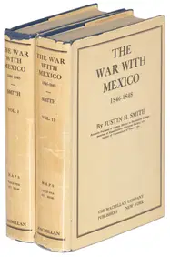
[HISTORIES]. SMITH. The War with Mexico.... 1919[HISTORIES]. SMITH, Justin Harvey. The War with Mexico, 1846-1848. New York: The MacMillan Company, 1919. 2 vols. Vol. I: [i-vi] vii-xxii, 1-1572 pp., 1 colored map; Vol. II: [i-iv] v-xiv, 1-620 pp. 8See Sold Price
Sold1796 MATTHEW CAREY ATLAS MAP OF VERMONT.18th C. hand colored “Map of Vermont from Actual Survey, Delineated and Engraved by Amos Doolittle” (1754-1832). Engraved for Carey’s American Edition of Guthrie’s Geography ImSee Sold Price
SoldAMOS DOOLITTLE/ CAREY'S MAP OF VERMONT.Early hand-colored map, Vermont From actual Survey Delineated & Engraved by Amos Doolittle N.H., Engraved for Carey's American Edition of Guthrie's Geography Improved.Image 15.5” x 12”, OvSee Sold Price
Sold(2) 1860 MAP, MOSTLY TEXAS & SOUTHERN STATES MAP(2) Framed Map: Louisiana, Mississippi, Arkansas and Part of Texas, from Smith's New Geography, J.B. Lippincott & Co., 1861, Philadelphia (Roswell C. Smith, 1797-1875), hand colored, sight: 11.75"h, 1See Sold Price
Morse's System of Geography, school atlas, 1848Title: System of Geography, for the Use of Schools... Author: Morse, Sidney E. Description: With 36 hand-colored wood-engraved maps; plus wood engravings (including 2 hand-colored charts of the HemispSee Sold Price
SoldMorse's System of Geography, school atlas, 1848Title: System of Geography, for the Use of Schools... Author: Morse, Sidney E. Description: With 36 hand-colored wood-engraved maps; plus wood engravings (including 2 hand-colored charts of the HemispSee Sold Price
Sold1848 Houze ATLAS Geography 101 MAPS Europe Africa1848 Houze ATLAS Geography 101 MAPS Europe Africa America Hand-Colored England A rare 19th-century atlas filled with over 100 full-page maps hand-traced in color. These maps by Antoine Philippe HouzeSee Sold Price
Two atlases with maps of the Holy Land. Start of theTwo atlases with maps of the Land of Israel, London and New York prints. *Â Atlas of the Historical Geography of the Holy Land. Edited by George Adam Smith. London, 1915. 60 colored geographical mapSee Sold Price
SoldGoodrich Geography with colored maps 1855Heading: Author: Goodrich, S[amuel] G[riswold] Title: The World as it Is, and as it Has Been; or a Comprehensive Geography and History, Ancient and Modern Place Published: New York Publisher:PublisheSee Sold Price
SoldATLAS OF CLASSICAL GEOGRAPHY-Hand Colored maps-1856Title: ATLAS OF CLASSICAL GEOGRAPHY-Hand Colored maps-1856 Provenance: by Hughes, William (Constructed by) and Long, George (edited by). . About this Item: Blanchard and Lea, Philadelphia, 1856. HardcSee Sold Price
Sold1822 Woodbridge School Atlas of maps1822 Woodbridge school Atlas of maps to accompany Woodbridge's Rudiments of Geography, hand colored maps,See Sold Price
SoldHand colored Map of Europe 184819.5"x 15.5" , Published by L Stebbins, Hartford, CT in 1848See Sold Price
SoldConant family, W. Cornwall, VT books & 1867 DC journalincluding 1841 Atlas of Ancient Geography w/ hand colored maps signed Samuel M Conant Middlebury CollegeSee Sold Price
SoldWilliam Channing Woodbridge MODERN ATLAS ON A NEW PLANWilliam Channing Woodbridge MODERN ATLAS ON A NEW PLAN TO ACCOMPANY THE SYSTEM OF UNIVERSAL GEOGRAPHY 1831 Hand-Colored Maps Tables Charts Political Physical Zoological Population Commerce United StatSee Sold Price
SoldMap of Mexico | Map of Central AmericaTitle/Content of Map: Map of Mexico | Map of Central America Date: 1853 Cartographer: SMITH, ROSWELL C. Size: 10.3Height - 8.75Width Publisher: DANIEL BURGESS & CO. From Smith's New Geography. Two mapSee Sold Price
Sold1831 S Butler "Atlas of Ancient Geography" with han1831 S Butler "Atlas of Ancient Geography" with hand colored mapsSee Sold Price
Map of South AmericaTitle/Content of Map: Map of South America Date Printed: 1844 Cartographer: SHERMAN/SMITH Size: 10.5X8.5 "Designed to accompany Smith's Geography for Schools." Map showing South America with France inSee Sold Price
South AmericaTitle/Content of Map: South America Date Printed: 1860 Cartographer: BOYNTON, G. W. Size: 6.1X4.3 Unidentified hand colored geography map. Please note that this lot has a confidential reserve. When yoSee Sold Price
Rand McNally Township County and Railroad Map of Indiana-1880JM Hobby Supply and Railroad Artifact Auctions4.4(126)See Sold PriceFeb 24, 2024
PIETER SCHENK / VALK / JANSSEN Hand Colored Map of Rhodes Greece ca1702 vgcLuis Porretta Fine Arts4.3(10)See Sold PriceMar 02, 2024
RIGOBERT BONNE c1787 Original Colored Map Germany & Region 15" x 12"Luis Porretta Fine Arts4.3(10)See Sold PriceMar 02, 2024
THOMAS MOULE 1837 Colored Map of Warwickshire Framed vgcLuis Porretta Fine Arts4.3(10)See Sold PriceMar 02, 2024
Hand Colored Map of the city of Amsterdam 1720Global Auctions Company4.3(36)See Sold PriceMar 03, 2024
HAMMOND'S READY REFERENCE HISTORICAL ATLAS 1920North American Artifact Auctions4.7(175)See Sold PriceApr 20, 2024
[MAPS]. DUFOUR, Auguste-Henri (1795-1865). Bound Volume of ...Potter & Potter Auctions4.6(538)See Sold PriceMar 07, 2024
D'Oyly (Calcutta, India) - Government House from St. Andrew's LibraryTrillium Antique Prints & Rare Books4.5(28)See Sold PriceFeb 24, 2024
D'Oyly (Calcutta, India) - Procession of the CurruckpoojaTrillium Antique Prints & Rare Books4.5(28)See Sold PriceFeb 24, 2024
Mitchell - Map of the City of Washington (Washington, DC)Trillium Antique Prints & Rare Books4.5(28)See Sold PriceFeb 24, 2024
Rees & Macpherson 1820 Lot of 6 Ancient Geography MapsAlbion Auctions4.7(335)See Sold PriceMar 01, 2024
Galliae Regionis Nova Descriptio Hand Colored Map of France on Laid Paper, Ca. 16th Century, H 10" WDuMouchelles4.6(822)See Sold PriceMar 15, 2024


![[HISTORIES]. SMITH. The War with Mexico.... 1919 (1 of 3)](https://p1.liveauctioneers.com/514/95447/48676162_1_x.jpg?height=282&quality=70&version=1477936208)


![[MAPS]. DUFOUR, Auguste-Henri (1795-1865). Bound Volume of ... (1 of 2)](https://p1.liveauctioneers.com/928/318880/171361279_1_x.jpg?height=282&quality=70&version=1707501302)