ATLAS of ANTIENT GEOGRAPHY by SAMUEL BUTLER 1843John McInnis Auctioneers,LLC4.6(502)See Sold PriceFeb 24, 2024
18TH C. ANTIQUE MAP: FRENCH & INDIAN WAR, FRAMEDThomaston Place Auction Galleries4.4(386)See Sold PriceFeb 24, 2024
Rand McNally Railroad Map Cabinet w/ 21 Railroad MapsRail & Road Auctions4.6(165)See Sold PriceMar 08, 2024
Keith Haring - Ink on New York Map, Best Buddies, Inscribed, Signed, and DatedSapphire Auction Gallery4(67)See Sold PriceMar 02, 2024
LATE 17TH C. FRENCH MAP OF THE NEW WORLD BY ALEXIS-HUBERT JAILLOT (1632-1712)Thomaston Place Auction Galleries4.4(386)See Sold PriceFeb 24, 2024
Central Railroad of New Jersey Map of Sandy Hook Route-ca. 1903JM Hobby Supply and Railroad Artifact Auctions4.4(126)See Sold PriceFeb 24, 2024
Lot of Six Mixed Atlas Box Cars-HO Scale-New in BoxJM Hobby Supply and Railroad Artifact Auctions4.4(126)See Sold PriceFeb 25, 2024
Rand McNally/Santa Fe Railroad Map of Iowa-1912JM Hobby Supply and Railroad Artifact Auctions4.4(126)See Sold PriceFeb 24, 2024
NICOLAES VISSCHER (NETHERLANDS, 1618-1709) MAP OF THE NEW WORLDThomaston Place Auction Galleries4.4(386)See Sold PriceFeb 24, 2024
17TH C. WORLD MAP BY NICOLAES VISSCHER (NETHERLANDS, 1618-1709)Thomaston Place Auction Galleries4.4(386)See Sold PriceFeb 24, 2024
Lot of Six Mixed Atlas Cabooses-HO Scale-New in BoxJM Hobby Supply and Railroad Artifact Auctions4.4(126)See Sold PriceFeb 25, 2024
Sold1848 Map of "Coast of N. American- Pt Judith to Cape1848 Map of "Coast of N. American- Pt Judith to Cape St. Antonio", This long rolled up map, 30 1/2" wide x 11' long, some damage and small losses at both ends, roll creases and small stains. PublishedSee Sold Price
SoldOIL ON CANVAS, FRANK KNOX MORTON REHNOIL ON CANVAS, VIEW ALONG THE COAST (POSSIBLY MASSACHUSETTS/CAPE COD), SIGNED F.K.M. REHN (FRANK KNOX MORTON, AMERICAN N.A. 1848-1914). 16 X 28" **DUE TO THE SIZE AND/OR FRAGILITY OF THIS LOT, STANDARSee Sold Price
Bellin, J. N; Jeffreys, T. Chart of American East CoastBellin, Jacques Nicolas; Jeffreys, Thomas A new chart of the coast of New England, Nova Scotia, New France or Canada, with the islands of Newfoundland. Cape Breton St. John's : done from the originalSee Sold Price
SoldBLUNT. AMERICAN COAST PILOT. N/R. BluntBLUNT. AMERICAN COAST PILOT. N/R. Blunt, Edmund M. The American Coast Pilot... 11th edition. N.Y., 1827. 676 pp + appendix and ads. Foldout maps, charts. Foxed; otherwise good and tight in rubbed leatSee Sold Price
SoldANTIQUARIAN AMERICAN EAST COAST SAILING VOLUME WITH MAPSANTIQUARIAN AMERICAN EAST COAST SAILING VOLUME WITH MAPS, Blunt, The American Coast Pilot: Containing the Courses and Distances Between the Principal Harbours, Capes, and Headlines, of the CoastSee Sold Price
American Coast Pilot, 6th Ed. with mapsHeading: Author: Furlong, Lawrence Title: The American Coast Pilot: Covering the Course and Distances Between the Principal Harbours, Capes and Headlands, from Passamaquoddy, through the Gulf of FlorSee Sold Price
... Sketch A. Showing the Primary Triangulation inTitle: ... Sketch A. Showing the Primary Triangulation in Section No. I from 1844 to 1855 [Passamaquoddy Bay to Pt. Judith Light] Publication Date: 1855 Cartographer: U.S. COAST SURVEY Publisher: U.S.See Sold Price
SoldVancouver: Antique Chart of Northwest Coast of AmericaTitle/Content of Map: A Chart Shewing Part of the Coast of N.W. America, with the Tracks of His Majesty's Sloop Discovery and Armed Tender Chatham . . . [Columbia River to Northern California] Date PrSee Sold Price
SoldA Chart of the North Pacific OceanDescription: Folding map with mainly coastal details of west coast of N. AM. from Shoal Water Bay to Icy Cape including Catherines Archipelago (Aleutians), details of Indians inland. Material: Paper MSee Sold Price
Atlantic Coast Map of the United States, 1864Map: Atlantic Coast of the United States (in Four Sheets) Date: 1864 Authors: U.S.C.S., U.S. COAST SURVEY Publisher: U.S.C.S. Size: Folio – 23.30 H x 27.60 W Inches "Sheet No.I Cape Sable to Sandy HSee Sold Price
SoldThe American Coast Pilot: Containing Directions for theBlunt, Edmund. The American Coast Pilot: Containing Directions for the Principal Harbors, Capes, and Headlands, on the Coasts of North and South America. New York: Edmund and George W. Blunt, 1854. SeSee Sold Price
SoldFurlong. American Coast Pilot. 1804.[Americana] Furlong, Lawrence. The American Coast Pilot: containing the courses and distances between the principal harbours, capes and headlands, from Passamaquoddy, through the Gulf of Florida. PrinSee Sold Price
Civil War Map of the Coast, Cape May - Cape Henry, 1862Map: General Map of the Coast No. IV from Cape May to Cape Henry Publication Date: 1862 Authors: U.S. COAST SURVEY, BACHE, A.D./HASSLER, F.R. Publisher: U.S. COAST SURVEY Size: Wall – 31.00 H x 31.0See Sold Price
USCGS: Antique Survey Map of US Atlantic Coast, 1889United States Coast and Geodetic survey sketch showing the progress of the survey in sections 3&4 June 30, 1888' USA ATLANTIC COAST:Chesapeake & Delaware Bay.Cape Fear & Lookout Date Printed: 1889 ImaSee Sold Price
USCGS: Antique Map of Florida East Coast, 1881United States Coast and Geodetic survey progress sketch sec. VI East Coast of Florida Halifax river to cape Canaveral' Daytona Beach. Notes on the historical context / background to the map can be vieSee Sold Price
Antique Sea Chart of Argentina Coast, 1901TITLE/CONTENT OF MAP: 'South America East Coast - Cape Dos Bahias to Staten Island' DATE PRINTED: Surveyed 1828-1868; Published 1901 IMAGE SIZE: Approx 67.5 x 106.0cm, 26.75 x 41.5 inches (Large); PleSee Sold Price
Walker: Antique Map of South America West Coast, 1840Map: Peru Pescadores Pt. to Independencia Bay South America West Coast Sheet XII Publication Date: 1840-12-29 Authors: Hydrographic Office of the Admiralty, Robert Fitz Roy with J. & C. Walker PublishSee Sold Price
SoldBellin/Jefferys: Antique Map of Canada & Islands, 1746Map: A new chart of the coast of New England, Nova Scotia, New France or Canada, with the islands of Newfoundl’d. Cape Breton, St. John’s &c. Publication Date: 1746 Authors: Gentleman’s MagazineSee Sold Price
1700 Sanson Map of Great Lakes and American East Coast -- Le Canada, ou Nouvelle France, &c. TireeTitle: 1700 Sanson Map of Great Lakes and American East Coast -- Le Canada, ou Nouvelle France, &c. Tiree de Diverses Relations des Francois, Anglois, Hollandois, &c. Cartographer: N Sanson Year / PlaSee Sold Price
Blunt West Coast of NABLUNT, Edmund March (1770-1862) and George William BLUNT. West Coast of North America, from the Gulf of Dulce to San Francisco. Engraved map. New York: E. & G.W. Blunt, 1848. Sheet 22 1/4" x 35 1/4";See Sold Price
SoldCape Fear River & the Approaches to Wilmington, N.C.Map: Showing the Entrances to Cape Fear River and the Approaches to Wilmington, N.C. Date: ca. 1885 Size: 9.5 x 7 inches No Reserve: This lot starts at $1 and has no reserve as a courtesy so that collSee Sold Price
USCGS: Antique Survey Map of New England, 1889United States Coast and Geodetic survey sketch showing the progress of the survey in sections 1&2 Inset maps of St. Croix River and N.E. Boundary; sketch showing the progress of the survey in SectionSee Sold Price
Florida Lithograph MapSketch F Showing the Progress of the Survey in Section VI (Lower Sheet) from Cape Florida to Tortugas Islands from 1845 to 1863...Washington, D.C: U.S. Coast survey, 1863. 20 x 34 inches visible, 26 1See Sold Price
Map of Bolivia and Peru Cape Paquica to Cape LobosTitle/Content of Map: Bolivia and Peru Cape Paquica to Cape Lobos South America West Coast Sheet XI Date Printed: 1865-04-01 Cartographer: Robert Fitz Roy Size: 24.25X18.6 seven long coastal views toSee Sold Price
N Denar (US,early 20C) watercolor painting antiqueBroward Auction Gallery4.8(277)See Sold PriceMar 17, 2024
LATE 18TH C. VERY LARGE CHART OF NORTHEAST CANADA BY DES BARRES (1721-1824), 1780, FRAMEDThomaston Place Auction Galleries4.4(386)See Sold PriceFeb 24, 2024
George Adomeit (American 1879-1964) CAPE COD LandscapePremier Auction Galleries4.3(329)See Sold PriceMar 09, 2024
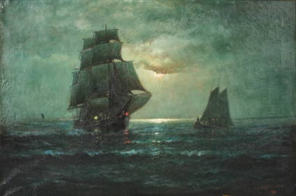
SOLON FRANCIS MONTECELLO BADGER (Massachusetts, 1873-1919), Portrait of the four-masted schoonerEldred's4.7(409)See Sold PriceFeb 28, 2024
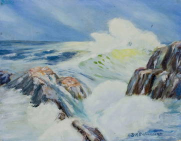
D N Richardson (US,early 20C) oil painting antiqueBroward Auction Gallery4.8(277)See Sold PriceApr 14, 2024
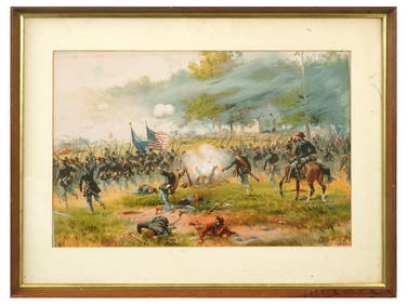
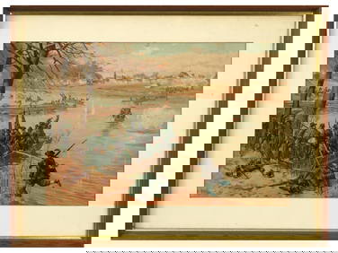
ANTIQUE AMERICAN CIVIL WAR LITHO BY THURE DE THULSTRUPAntique Arena Inc.4.5(852)See Sold PriceFeb 24, 2024
ANTIQUE AMERICAN CIVIL WAR LITHO BY THURE DE THULSTRUPAntique Arena Inc.4.5(852)See Sold PriceFeb 24, 2024
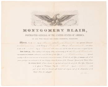
SOMERSET, Lord Charles (1767-1831) and BLAIR, Montgomery (1...Potter & Potter Auctions4.6(539)See Sold PriceMar 07, 2024
[ENSLAVEMENT & ABOLITION]. A group of 3 prints related to the Atlantic slave trade, including plansFreeman's | Hindman4.4(1.6k)See Sold PriceFeb 27, 2024
GEORGE GUSTAV ADOMEIT (1879-1967) "CAPE COD".Amelia Jeffers, Auctioneers & Appraisers4.6(101)See Sold PriceMar 07, 2024
ENGLISH HISTORICAL BLUE STAFFORDSHIRE PLATTER.Amelia Jeffers, Auctioneers & Appraisers4.6(101)See Sold PriceMar 08, 2024
James J. McAULIFFE (1848 - 1921) AmericanPridham's Auctions & Appraisals4.7(223)See Sold PriceMar 02, 2024


![[ENSLAVEMENT & ABOLITION]. A group of 3 prints related to the Atlantic slave trade, including plans (1 of 3)](https://p1.liveauctioneers.com/197/319238/171468007_1_x.jpg?height=282&quality=70&version=1707520367)