ATLAS of ANTIENT GEOGRAPHY by SAMUEL BUTLER 1843John McInnis Auctioneers,LLC4.5(505)See Sold PriceFeb 24, 2024
18TH C. ANTIQUE MAP: FRENCH & INDIAN WAR, FRAMEDThomaston Place Auction Galleries4.4(393)See Sold PriceFeb 24, 2024
Rand McNally Railroad Map Cabinet w/ 21 Railroad MapsRail & Road Auctions4.6(165)See Sold PriceMar 08, 2024
Keith Haring - Ink on New York Map, Best Buddies, Inscribed, Signed, and DatedSapphire Auction Gallery4.1(67)See Sold PriceMar 02, 2024
LATE 17TH C. FRENCH MAP OF THE NEW WORLD BY ALEXIS-HUBERT JAILLOT (1632-1712)Thomaston Place Auction Galleries4.4(393)See Sold PriceFeb 24, 2024
Central Railroad of New Jersey Map of Sandy Hook Route-ca. 1903JM Hobby Supply and Railroad Artifact Auctions4.4(127)See Sold PriceFeb 24, 2024
Lot of Six Mixed Atlas Box Cars-HO Scale-New in BoxJM Hobby Supply and Railroad Artifact Auctions4.4(127)See Sold PriceFeb 25, 2024
Rand McNally/Santa Fe Railroad Map of Iowa-1912JM Hobby Supply and Railroad Artifact Auctions4.4(127)See Sold PriceFeb 24, 2024
NICOLAES VISSCHER (NETHERLANDS, 1618-1709) MAP OF THE NEW WORLDThomaston Place Auction Galleries4.4(393)See Sold PriceFeb 24, 2024
17TH C. WORLD MAP BY NICOLAES VISSCHER (NETHERLANDS, 1618-1709)Thomaston Place Auction Galleries4.4(393)See Sold PriceFeb 24, 2024
Lot of Six Mixed Atlas Cabooses-HO Scale-New in BoxJM Hobby Supply and Railroad Artifact Auctions4.4(127)See Sold PriceFeb 25, 2024
I.M.R. 3rd District. Map Showing Area Overflowed inPublication Date: 1894-06-30 Title: I.M.R. 3rd District. Map Showing Area Overflowed in 1893. Cartographer: TOWNSEND, CURTIS MCDONALD (1856-1941) Publisher: GPO/MISSISSIPPI RIVER COMMISSION Height: 21See Sold Price
I.M.R. Third District ... Map Showing Overflow fromI.M.R. Third District ... Map Showing Overflow from Backwater May, 1904.. CORPS OF ENGINEERS, LUCAS, E.W. VAN C. /R. C. FENTON, 1904, Folio - 18.75 H x 13.00 W Inches, "Capt. E.W. Van C. Lucas, CorpsSee Sold Price
SoldSectional Map of the City Showing Burned DistrictSectional Map of the City Showing Burned District… from History of Chicago 9.2 X 5.9 in. Simple map showing the Chicago fire area. Verso is text from History of Chicago Please note that this lot hasSee Sold Price
Sold[Chicago] Map Showing the Burnt District in Chicago.[Chicago] Map Showing the Burnt District in Chicago. St. Louis: R.P. Studley Co., 1870s. Fourth Edition. Two-color engraved map of the city delineating the areas affected by the Great Fire of 1871. 24See Sold Price
1856 Colton Map Canadian Maritime Provinces"Colton's New Brunswick, Nova Scotia, Newfoundland, and Prince Edward Id.". Areas of hand coloring showing fishing with index to lower margin. Published by G.W. & C. B. Colton & Co., No. 172 William SSee Sold Price
SoldWWI Paper ItemsOriginal WW1 Map of D'Argonne Forest Area, France, Marked "Secret", showing troop locations. Identified to "Major Norris" of the "3rd Battalion". Ship: $18 plus insurance.See Sold Price
Sold1837 Diagram Map of Illinois"No. 2 (C) (accompanying report of 30th October 1837) Diagram of the State of Illinois". Showing the state divided into plats. Areas of yellow, blue, and green hand coloring. Good condition; some ageSee Sold Price
SoldLarge 18th century wall map showing areas around tLarge 18th century wall map showing areas around the Caspian Sea including Persia, Sarmatia, etc. 20" x 23". Provenance: From a private Kingston NY collection.See Sold Price
SoldAutomobile Map of Los Angeles 1913Heading: (California - Los Angeles) Author: Title: Los Angeles Trust and Savings Bank - Map of Los Angeles City also a District Map showing Automobile Roads and other Routes of Travel Place PublishedSee Sold Price
SoldTWO 19TH CENTURY FRENCH HAND COLORED ENGRAVED MAPTWO 19TH CENTURY FRENCH HAND COLORED ENGRAVED MAPS showing areas of France and Belgium with depictions of produce from various sections such as wine, fish, cheese, meat and grains. Each 12 in. by 17 3See Sold Price
Sold23 Maps/Views incl: Tartaria Sive Magni Chami...[Asia/India] 23 Maps/Views. ++ Tartaria Sive Magnichami Imperiorum. Folding map showing the area from the Caspian Sea to China [Matthaus Merian, c. 1646]. Numerous place names, many in areas that hadSee Sold Price
SoldAtlas of the Village of Hyde Park…by Dobson & Rhoades,Atlas of the Village of Hyde Park…by Dobson & Rhoades, Engineers. Chicago: Rhoades, Dobson, and Rascher, ca. 1870s. Lithographed title page, index map, and Plate 5 only. Index map showing the area fSee Sold Price
SoldCenomanorum Galliae regionis typus. [Ca 1630s-40s][Blaeu/France]. Cenomanorum Galliae regionis typus: Vulgo Le Mans. Double-page map showing the area to the south of Normandy, north of Touraine, and to the west of Brittany. Over 2 dozen locations beaSee Sold Price
A FRAMED HAND COLOURED GEOLOGICAL SURVEY MAP, showingA FRAMED HAND COLOURED GEOLOGICAL SURVEY MAP, showing an area of Great Britain and the River Wye. 37 cm x 52 cm.See Sold Price
Sold(MAP) VISSCHER, NICOLAUS. [Amsterdam, c. 1690](MAP) VISSCHER, NICOLAUS Tabula nova Provinciae Ultrajectinae, [Amsterdam, c. 1690] Hand-colored engraved map showing the areas between Amsterdam, Gouda, Arnheim and Zutphen, including Utrecht and AmeSee Sold Price
Sold2 Early Maps, Britain and FranceTwo (2) Early Maps, Britain and France. 1st item: L'ISLE DE FRANCE, PARISIENSIS AGER, hand colored and engraved map showing the areas around Paris with small tree illustrations to denote forests; undaSee Sold Price
Antique Map, ‘Independent Tartary’,framed hand-coloured map showing tribal areas around the Aral Sea in Central Asia, and with attractive vignettes at four corners. Image size 33cm x 26cm (approx)See Sold Price
SoldLloyd's 1897 Lot of 8 World Natural History Maps8 World Maps showing the areas where Primates live. Chromolithographs Published 1894-97, London for "Lloyds's Natural History..." Edited by R. Bowdler Sharpe, W. F. Kirby, H. O. Forbes, R. Lydekker, aSee Sold Price
SoldLloyd's 1897 Lot of 8 World Natural History Maps8 World Maps showing the areas where Primates live. Chromolithographs Published 1894-97, London for "Lloyds's Natural History..." Edited by R. Bowdler Sharpe, W. F. Kirby, H. O. Forbes, R. Lydekker, aSee Sold Price
SoldThomson map, United States and Additions, 1820[United States]. J. Thomson. United States And Additions, 1820. Double page engraved map showing the entire area from the Atlantic to the Pacific, including lower Canada and portions of Central AmericSee Sold Price
SoldThomson map, United States and Additions, 1820.[United States]. J. Thomson. United States And Additions, 1820. Double page engraved map showing the entire area from the Atlantic to the Pacific, including lower Canada and portions of Central AmericSee Sold Price
SoldCubaReserve Reduced! Title/Content of Map: CubaDate: 1888 Cartographer: BRADLEY, WM. M. Material/Medium: WM. M. BRADLEY & BROS. Size: 11 x 14.5 inches Detailed map showing districts, towns, bays, roads, rSee Sold Price
SoldUpper & Lower Canada.Reserve Reduced! Title: Upper & Lower Canada. Publication Date: 1835 Cartographer: BRADFORD, T.G. Publisher: AMERICAN STATIONERS COMPANY Size: 7.5 X 9.75 Map showing districts separately colored, townSee Sold Price
Upper CanadaTitle: Upper Canada Publication Date: 1838 Cartographer: BRADFORD, T.G./ENGR. BY G.W. BOYNTON Publisher: BRADFORD, T.G. Brief Descriptions: Map showing districts separately colored, towns, forts, townSee Sold Price
NATIONAL MAZDA LAMPS TRI-FOLD STORE DISPLAY W/ CAR GRAPHIC.Dan Morphy Auctions4.2(1.3k)See Sold PriceFeb 24, 2024
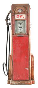
FRY MAE WEST TEN GALLON VISIBLE GAS PUMP RESTORED IN TYDOL COLORS.Dan Morphy Auctions4.2(1.3k)See Sold PriceFeb 24, 2024
TOKHEIM MODEL #39 GAS PUMP RESTORED IN TEXACO MARINE WHITE GASOLINE.Dan Morphy Auctions4.2(1.3k)See Sold PriceFeb 24, 2024
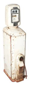
OUTSTANDING ECO TIRE METER SERVICE STATION AIR & WATER ISLAND / GLOBE & LIGHT DISPLAY.Dan Morphy Auctions4.2(1.3k)See Sold PriceFeb 24, 2024
BENNETT MODEL #541 GAS PUMP RESTORED IN SOHIO GASOLINE.Dan Morphy Auctions4.2(1.3k)See Sold PriceFeb 24, 2024
BOWSER & CO. MODEL #565 GAS PUMP RESTORED IN SINCLAIR GASOLINE.Dan Morphy Auctions4.2(1.3k)See Sold PriceFeb 24, 2024
TOKHEIM MODEL #39 GAS PUMP RESTORED IN SINCLAIR GASOLINE.Dan Morphy Auctions4.2(1.3k)See Sold PriceFeb 24, 2024
BENNETT MODEL #1056 GAS PUMP RESTORED IN AMOCO GASOLINE.Dan Morphy Auctions4.2(1.3k)See Sold PriceFeb 24, 2024
ECO AIR-METER SERVICE STATION AIR PUMP W/ RETRACTABLE HOSE BASE.Dan Morphy Auctions4.2(1.3k)See Sold PriceFeb 24, 2024
GILBERT & BARKER CURB STYLE PUMP RESTORED IN PURE GASOLINE.Dan Morphy Auctions4.2(1.3k)See Sold PriceFeb 25, 2024
UNIQUE CUSTOM MADE VISIBLE GAS PUMP CYLINDER BIRD FEEDER.Dan Morphy Auctions4.2(1.3k)See Sold PriceFeb 25, 2024
PHILLIPS 66 GASOLINE LIGHTED PLASTIC SERVICE STATION SIGN W/ SHIELD GRAPHIC.Dan Morphy Auctions4.2(1.3k)See Sold PriceFeb 25, 2024
Pair of The Gateway to a Continent Books - Grand Central Zone and 1939 World's FairRail & Road Auctions4.6(165)See Sold PriceMar 07, 2024
WEST AFRICA Explorers' routes Senegal Ashanti. Mountains of Kong. SDUK 1857 mapJasper524.5(9.9k)See Sold PriceFeb 28, 2024
AFRICA. Map pre-dating much exploration. Mountains of Kong. SDUK 1851 oldJasper524.5(9.9k)See Sold PriceFeb 28, 2024
WEST AFRICA explorers' routes. Beaufort Gray Park Dochard Caillie. SDUK 1874 mapJasper524.5(9.9k)See Sold PriceFeb 28, 2024
WEST AFRICA I Explorers' routes Senegal Ashanti Ivory Gold Coast. SDUK 1851 mapJasper524.5(9.9k)See Sold PriceFeb 28, 2024
WEST AFRICA showing early explorers' routes & Mountains of Kong. SDUK 1844 mapJasper524.5(9.9k)See Sold PriceFeb 28, 2024
Operation Torch Nov 1942-May 1943. World War 2. Western Mediterranean 1966 mapJasper524.5(9.9k)See Sold PriceFeb 28, 2024
PRE COLONIAL WESTERN AFRICA. Shows Mountains of Kong. Tribes. WELLER 1863 mapJasper524.5(9.9k)See Sold PriceFeb 28, 2024


![[Chicago] Map Showing the Burnt District in Chicago. (1 of 1)](https://p1.liveauctioneers.com/928/93171/47564355_1_x.jpg?height=282&quality=70&version=1472660174)


![Cenomanorum Galliae regionis typus. [Ca 1630s-40s] (1 of 2)](https://p1.liveauctioneers.com/179/41615/18011172_1_x.jpg?height=282&quality=70&version=1369948904)

![(MAP) VISSCHER, NICOLAUS. [Amsterdam, c. 1690] (1 of 1)](https://p1.liveauctioneers.com/197/30916/12134084_1_x.jpg?height=282&quality=70&version=1342619735)