17TH C. ENGLISH LINEAR MAP BY OGILBY, FRAMEDThomaston Place Auction Galleries4.4(386)See Sold PriceFeb 24, 2024
OGILVY & BOWEN c1736 Original Map of Oxfordshire Berkshire Etc.Luis Porretta Fine Arts4.3(10)See Sold PriceMar 02, 2024
THOMAS MOULE 1837 Colored Map of Warwickshire Framed vgcLuis Porretta Fine Arts4.3(10)See Sold PriceMar 02, 2024
SoldThornton Map of the WorldTHORNTON, John (1641–1708). A New Mapp of the World According to Mr. Edward Wright Commonly called Mercator's Projection..." Engraving with original hand color.From Atlas Maritimus or the Sea Atlas.See Sold Price
SoldGROUP OF MAPSThree: "A New Map of the Trading Part of America" by John Thornton, London, "A Map of a New World Between New Mexico and the Frozen Sea" by Lewis Hennepin, England and map of Hispaniola, Cuba and otheSee Sold Price
SoldThe World Crisis-Winston S. Churchill, 2 volumes, 1927,The World Crisis-Winston S. Churchill, 2 volumes, 1927, 1929, 1st Editions, Thornton Butterworth, Ltd, London, The World Crisis, 1916-1918, Part II, The Aftermath, dark blue cloth, both volumes in verSee Sold Price
Horsey: Pictorial Map, World According to Ronald ReganTitle/Content of Map: 1982 Horsey Pictorial Map of the World According to Ronald Regan -- The World According to Ronald Regan Date Printed: 1982 Cartographer: D Horsey / Seattle Post-Intelligencer SizSee Sold Price
SoldGuthrie, William 1798 Map World of Mercators ProjectionCopper Engraved Map Published 1798, London for "A New Geographical, Historical and Commercial Grammar..." by William Guthrie. The maps are by John Senex, Thomas Kitchin and others. Folds as issued. PaSee Sold Price
SoldGuthrie, William 1798 Map. World HemispheresCopper Engraved Map Published 1798, London for "A New Geographical, Historical and Commercial Grammar..." by William Guthrie. The maps are by John Senex, Thomas Kitchin and others. Folds as issued. PaSee Sold Price
SoldStrategic Russian Map, World War I, 1917Strategic Russian Map, World War 1. 54x62 cm. Date: 1917 Shipping: Domestic: Flat-rate of $10.00 to anywhere within the contiguous U.S. International: Foreign shipping rates are determined by destinatSee Sold Price
SoldLochhead (Pub) 1811 Rare Map. World HemisphereCopper Engraved Map Published 1811 by William Lochhead, Berwick for "Modern Geography: And a Compendious General Gazetteer" Rare. Folds as issued. Paper Size: 17 x 11 inch (43 x 28cm) Some creasing. VSee Sold Price
SoldRapkin, John 1860 Map. World HemispheresSteel Engraved Map Published 1860 by The London Printing & Published Company, London for "The Royal Dictionary-Cyclopedia for Universal Reference" by Thomas Wright. Drawn & Engraved by John Rapkin. FoSee Sold Price
Tallis World Map World on Mercator's Projection 1851Tallis World Map The World on Mercator's Projection 1851. T. Jefferys, 1757 London, 6 X 10.6 In.. This Is an Attractive and Charming Double Hemisphere Map, Colored, and Framed. it Is Set Against a BacSee Sold Price
Bradford: Set of 2 Antique Maps, World in HemispheresTitle/Content of Map: Set of 2 Maps together World in globular projection by Bradford Date Printed: 1835 Cartographer: T.G. Bradford Material/Medium: Paper Size: 9 1/2" x 13" each A comprehensive AtlaSee Sold Price
Sold[MAP - WORLD]. BOWEN, Emanuel (d. 1767). Niewe en[MAP - WORLD]. BOWEN, Emanuel (d. 1767). Niewe en Naukeurige Kaart des geheelen Aardbodems' [Amsterdam,] 1744. Engraved map hand-colored in outline, visible area 515 x 610 mm, matted and framed (unexaSee Sold Price
SoldBecker, F. C1838 Antique Map. World on Mercator's Proj.Steel Engraved Map with outline hand color Published C1838, London for "A Complete and Universal English Dictionary" by the Rev. James Barclay et al. Maps by F. Becker and others. Paper Size: 10.5 x 8See Sold Price
Horsey: Pictorial Map World According to Ronald ReaganTitle/Content of Map: 1982 Horsey Pictorial Map of the World According to Ronald Reagan -- The World According to Ronald Reagan Date Printed: 1982 Cartographer: D Horsey / Seattle Post-Intelligencer SSee Sold Price
Sold[MAPS -- WORLD AND UNITED STATES]. Two maps,[MAPS -- WORLD AND UNITED STATES]. Two maps, comprising: [FACSIMILE]. SPEED, John (1552-1629). A New and Accurate Map of the World... N.p., 20th century. Printed in color. Matted and framed (not eSee Sold Price
SoldRapkin, John 1860 Map. World on Mercator's ProjectionSteel Engraved Map Published 1860 by The London Printing & Published Company, London for "The Royal Dictionary-Cyclopedia for Universal Reference" by Thomas Wright. Drawn & Engraved by John Rapkin. FoSee Sold Price
SoldBecker, F. C1850 Antique Map. World on Mercator's Proj.Steel Engraved Map with outline hand color Published C1850 "A Complete and Universal English Dictionary" by the Rev. James Barclay et al. Maps by F. Becker and others. Paper Size: 10.5 x 8 inch (27 xSee Sold Price
SoldRapkin, John 1860 Map. World on Mercator's ProjectionSteel Engraved Map Published 1860 by The London Printing & Published Company, London for "The Royal Dictionary-Cyclopedia for Universal Reference" by Thomas Wright. Drawn & Engraved by John Rapkin. FoSee Sold Price
SoldColored Antique Map World & Western Hemisphere 1898This colorful map came from Cram's 1898 Universal Atlas - Geographical, Astronomical and Historical. In 1869 the George F. Cram Company was born and the Cram name quickly became synonymous with accuraSee Sold Price
SoldBartholomew, John 1889 Lot of 4 Maps. World etcIncl Diseases/Population, Races/Religions, Isochronic Distance/Postal Map, and British Isles - Rain/Crops/Orographical/Pasture Land. Lithograph Maps Published 1889, Cambridge for "Atlas of CommercialSee Sold Price
SoldGross, Alexander 1920 Large Map. World HemispheresLarge Lithograph Map Published 1920, London for "The Daily Telegraph Victory Atlas of the World" by Alexander Gross. Centre fold as published. Paper Size: 25 x 19.5 inch (64 x 49cm) Good ConditionSee Sold Price
SoldMap World of Mercator's Projection John TallesMap World of Mercator's Projection John Talles - drawn & engraved by J. RapkinSee Sold Price
SoldAmerican Airlines Route Map World's Fair Line 1939American Airlines Route Map World's Fair Line 1939See Sold Price
Sold4 Circa 1939 Sinclair Road Maps Worlds FairMaps feature information on Sinclair exhibit about oil drilling at New York World's Fair. Iowa Sinclair road map has light wear near folds and has minor rip. New York Sinclair road map is in very goodSee Sold Price
17TH C. WORLD MAP BY NICOLAES VISSCHER (NETHERLANDS, 1618-1709)Thomaston Place Auction Galleries4.4(386)See Sold PriceFeb 24, 2024
Eretz Israel Map Postcard - World Zionist OrganizationLevy Auction House4.3(11)See Sold PriceFeb 27, 2024
Vintage Full Color World Map LithographThe Benefit Shop Foundation Inc.4.3(2.9k)See Sold PriceFeb 28, 2024
Nova Totius Full Color Geographical World MapThe Benefit Shop Foundation Inc.4.3(2.9k)See Sold PriceFeb 28, 2024
An Ebel Voyager automatic wristwatch with world time function, the dial with world map and dateClaydon Auctioneers Ltd4.3(125)See Sold PriceFeb 25, 2024
World map.- Macrobius (Ambrosius Aurelius Theodosius) In somnium Scipionis, Libri II. Saturnaliorum,Forum Auctions4.3(52)See Sold PriceFeb 29, 2024
Blackie (Pub) 1882 Folio Map. World on Mercators ProjectionAlbion Auctions4.6(336)See Sold PriceMar 01, 2024
1849 Hand Colored Blair Map of World in HemispheresMatthew Bullock Auctioneers4.7(1.8k)See Sold PriceMar 02, 2024
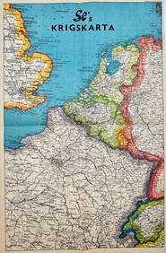
Vintage Map - Krigskarta - War Map - Second World War, published 1940Proverde Auctions4.3(3)See Sold PriceFeb 28, 2024


![[MAP - WORLD]. BOWEN, Emanuel (d. 1767). Niewe en (1 of 1)](https://p1.liveauctioneers.com/197/161882/81723385_1_x.jpg?height=282&quality=70&version=1581711364)


![[MAPS -- WORLD AND UNITED STATES]. Two maps, (1 of 1)](https://p1.liveauctioneers.com/197/161882/81723397_1_x.jpg?height=282&quality=70&version=1581711364)