Gothic Revival Stained Glass Window of The ResurrectionSchmidt's Antiques Inc. Since 19114.8(431)See Sold PriceMar 02, 2024
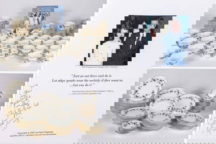
THE FITZGERALD FAMILY TEA and DINNER SERVICEJohn McInnis Auctioneers,LLC4.5(505)See Sold PriceFeb 25, 2024
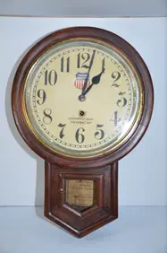
Union Pacific RR Cheyenne, WY Locomotive Shop ClockJM Hobby Supply and Railroad Artifact Auctions4.4(127)See Sold PriceFeb 24, 2024
A CHINESE PORCELAIN GREEN ENAMELED DRAGON MOON FLASK BIANHUBerkeley Auction Gallery4.4(16)See Sold PriceMar 03, 2024
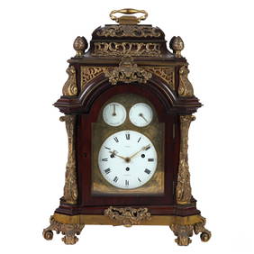
Antique George III Musical Bracket Clock by Hare LondonHill Auction Gallery 4.7(1k)See Sold PriceFeb 28, 2024
No Reserve Early 20th century French / Flemish Design Tapestry 6 ft 2 in x 4 ft 9 in (1.87 m x 1.44Nazmiyal Auctions4.4(34)See Sold PriceFeb 25, 2024
Central Anatolia Konya Antique Rug 4 ft 8 in x 3 ft 8 in (1.42 m x 1.11 m)Nazmiyal Auctions4.4(34)See Sold PriceFeb 25, 2024
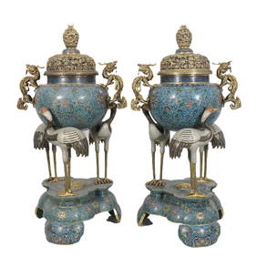
PAIR MAGNIFICENT AND LARGE CLOISONNE ENAMEL CRANES INCENSE BURNERSBerkeley Auction Gallery4.4(16)See Sold PriceMar 03, 2024
From Davide Halevim Collection Antique Persian Mohtashem Kashan Rug 10'11" x 7'10" (3.32 m x 2.38 m)Nazmiyal Auctions4.4(34)See Sold PriceFeb 25, 2024
RARE COVENTRY GLASS WORKS MASONIC FLASKJohn McInnis Auctioneers,LLC4.5(505)See Sold PriceFeb 25, 2024
Empire by Buccellati Italy Sterling Silver Flatware Set 99 pieces DinnerBidhaus4.4(762)See Sold PriceFeb 25, 2024
SoldFolding map of U.S. by S.A. Mitchell 1835Title: Mitchell's Map of the United States; Showing the Principal Travelling, Turnpike and Common Roads; on which are Given the Distances in Miles from One Place to Another; also, the Courses of the CSee Sold Price
SoldFolding map of U.S. by S.A. Mitchell 1831Heading: Author: Mitchell, Samuel Augustus Title: Map of the United States Constructed From the latest Authorities Place Published: Philadelphia Publisher:Published by S. Augustus Mitchell DateSee Sold Price
Folding map of U.S. by S.A. Mitchell 1831Heading: Author: Mitchell, Samuel Augustus Title: Map of the United States Constructed From the latest Authorities Place Published: Philadelphia Publisher:Published by S. Augustus Mitchell DateSee Sold Price
SoldMitchell's pocket map, United States,Map of the United States, constructed from the latest authorities, by S.A. Mitchell, Philadelphia, 1831, folding map with original cover, showing boundaries of eastern states, western territories, andSee Sold Price
SoldMitchell folding map of Louisiana 1835Title: Map of the States of Louisiana, Mississippi & Alabama Author:Mitchell, Samuel Augustus Description:Copper-engraved map, hand-colored. 45x55 cm. (17½x21½"), folding into original morocco coverSee Sold Price
SoldBook, "Mitchell's Traveller's GuideThrough the United States." Philadelphia, S. Augustus Mitchell, 1835. Two separate sheets (18" x 22 1/4") tipped in covers. One is a copper-engraved folding map, colored in outline, of the eastern UniSee Sold Price
SoldFolding map of U.S. & cities 1843Heading: Author: Mitchell, Samuel Augustus Title: Mitchell's National Map of the American Republic or United States of North America. Together with Maps of the Vicinities of Thirty-Two of the PrincipSee Sold Price
SoldS.A. Mitchell New Map of Texas, Oregon and CaliforniaA new map of Texas, Oregon and California with Regions Adjoining. Samuel Augustus Mitchell (1790-1860). Lithographed and hand colored folding pocket map framed, with original cloth binding. PhiladelphSee Sold Price
Folding map of U.S. & cities 1843Heading: Author: Mitchell, Samuel Augustus Title: Mitchell's National Map of the American Republic or United States of North America. Together with Maps of the Vicinities of Thirty-Two of the PrincipSee Sold Price
Folding map of U.S. & cities 1843Heading: Author: Mitchell, Samuel Augustus Title: Mitchell's National Map of the American Republic or United States of North America. Together with Maps of the Vicinities of Thirty-Two of the PrincipSee Sold Price
SoldPocket Map Indiana 1835MAP - YOUNG, J. H. The Tourist's Pocket Map of the State of Indiana.Philadelphia: S. Augustus Mitchell, 1835. Hand-colored engraved folding pocket map (390x325 mm). Folds into publisher's roSee Sold Price
Sold1847 MITCHELL’S NATIONAL MAP OF THE AMERICAN REPUBLIC1847 MITCHELL\'S NATIONAL MAP OF THE AMERICAN REPUBLIC. This impressive framed wall map was published by the S.A. Mitchell firm in both wall and folding pocket format from 1843 to 1850. Drawn by J.H.See Sold Price
MITCHELL, S. Augustus. Map of Texas.... 1846Yet Another Descendant of Young’s 1835 Texas Map 337. [MAP]. MITCHELL, S[amuel] Augustus. Map of Texas from the Most Recent Authorities.</See Sold Price
Sold* MITCHELL, S.A. Mitchell's Travellers Guide Through* MITCHELL, Samuel Augustus (1790-1868). Mitchell's Travellers Guide Through the United States. A Map of the Roads, Distances, Steam Boat & Canal Routes &c. Philadelphia, 1832. Folding engraved map haSee Sold Price
Sold1835 guide and map of U.S.Heading: (United States) Author: Mitchell, S[amuel] Augustus Title: Mitchell's Travellers Guide through the United States. A Map of Roads, Distances, Steam Boat & Canal Routes &c. By J.H. Young PlaceSee Sold Price
SoldMexico and Guatimala [sic.],J. H. Young / Samuel Augustus Mitchell, Mexico and Guatimala [sic.], lithograph (hand colored), probably from Travellers Guide through the U.S. (Philadelphia, 1835) , 10 x 8 10 x 8See Sold Price
SoldWESTERN HEMISPHERE MAP BY S.A. MITCHELL, 1884Hand colored and engraved map of the western hemisphere. Matted, 14.5 x 10.5 inch sight size. Not examined outside wrapping, appears excellent.See Sold Price
SoldFolding map of U.S. from Case, Tiffany 1852Title: Map of the United States Author: Case, Tiffany & Co. Description: Lithographed folding map on banknote paper, hand-colored. 59.5x61.5 cm. (23¼x24¼").Folding map of the United States just afteSee Sold Price
SoldColton's massive folding map of U.S. 1869Title: Colton's Map of the United States of America, the British Provinces, Mexico and the West Indies, Showing the Country from the Atlantic to the Pacific Ocean Author: Colton, G.W. & C.B. DescriptiSee Sold Price
Sold1860 California Map by S.A. Mitchell w/ Salt Lake &Beautiful 1860 County Map of California, with inset of Salt Lake Country, Utah, and inset of San Francisco Bay and Vicinity, by S.A. Mitchell. Frame-able condition. Nice color and great detail. "EnterSee Sold Price
SoldBurr's folding map of U.S. 1833Heading: Author: Burr, David H. Title: United States Place Published: New York Publisher:J.H. Colton & Co. Date Published: 1833 Description: Copper-engraved map, hand-colorSee Sold Price
WALL MAP - Eastern US. MitchellEastern United States. Samuel Augustus Mitchell, Mitchell's National Map of the American Republic or United States of North America, Together with Maps of the Vicinities of Thirty-Two of the PrincipalSee Sold Price
SoldLarge folding maps of U.S. & Canada 1853Heading: Author: Andrews, Israel De Wolf Title: Maps: Andrews' Report Place Published: [Washington, D.C.] Publisher:[Treasury Dept.] Date Published: 1853 Description: FourSee Sold Price
SoldRare "Fredonia" folding map of U.S. 1848Title: Fredonia. Or the United States of North America; including also Cabotia, or the Canadian Provinces; The Western Territory To the Pacific Ocean' And the Northern Part of the Mexican States AuthoSee Sold Price
FLYING A TOURING SERVICE U.S. ROAD MAPS TIN WALL DISPLAY.Dan Morphy Auctions4.2(1.3k)See Sold PriceFeb 25, 2024
1952 J.F.K. for US SENATE CAMPAIGN MATERIALS etcJohn McInnis Auctioneers,LLC4.5(505)See Sold PriceFeb 25, 2024
1849 Mitchell School ATLAS 24 MAPS America Holy Land France Africa Egypt AsiaSchilb Antiquarian Rare Books4.8(428)See Sold PriceMar 31, 2024
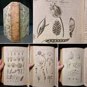
1797 Universal Magazine BOTANY PLATES Flowers FRUIT 12 Copper Engraved PlatesPrivate NY Collection4.2(22)See Sold PriceMar 01, 2024
WWI U.S. SA 1906 BAYONET WITH LEATHER SCABBARD.Amelia Jeffers, Auctioneers & Appraisers4.5(120)See Sold PriceMar 09, 2024
U.S. SA 1906 BAYONET WITH USN MK1 SCABBARD.Amelia Jeffers, Auctioneers & Appraisers4.5(120)See Sold PriceMar 09, 2024
Kent & Sussex.- Moss (W.G.) The History and Antiquities of the Town and Port of Hastings, 1824; andForum Auctions4.3(53)See Sold PriceFeb 29, 2024
Central Africa. Congo Free State Rhodesia German East Africa. STANFORD 1896 mapJasper524.5(9.9k)See Sold PriceFeb 28, 2024
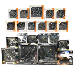
Twenty-one boxed die-cast scale models of mainly WWII aircraft by Unimax and Ixo, ((21))Bonhams4(320)See Sold PriceMar 01, 2024


![Mexico and Guatimala [sic.], (1 of 1)](https://p1.liveauctioneers.com/457/2714/1174422_1_x.jpg?height=282&quality=70)