SoldWESTERN HEMISPHERE MAP BY S.A. MITCHELL, 1884Hand colored and engraved map of the western hemisphere. Matted, 14.5 x 10.5 inch sight size. Not examined outside wrapping, appears excellent.See Sold Price
SoldTwo Maps by Samuel Augustus Mitchell (1790-1868),Two Maps by Samuel Augustus Mitchell (1790-1868), consisting of "Western Hemisphere", 1874, hand colored, H. -15 1/4 in., W. - 11 3/4 in.; together with "Eastern Hemisphere", 1884, hand colored, H. -1See Sold Price
SoldMitchell: Map of the Western Hemisphere, 1874Map: Western Hemisphere Publication Date: ca. 1874 Authors: S. Augustus Mitchell, Jr., MITCHELL, SAMUEL AUGUSTUS (JR.) Publisher: S. Augustus Mitchell, Jr. Size: Quarto – 7.75 W Inches Shows lengthsSee Sold Price
1876 Mitchell Map of the Western Hemisphere -- WesternTitle/Content of Map: 1876 Mitchell Map of the Western Hemisphere -- Western Hemisphere Date: 1876 Philadelphia Cartographer: S Mitchell Size: 13.8 X 9.8 in. This is a very nice map of the Americas, sSee Sold Price
1876 Mitchell Map of the Western Hemisphere -- WesternTitle/Content of Map: 1876 Mitchell Map of the Western Hemisphere -- Western Hemisphere Date: 1876 Philadelphia Cartographer: S MitchellSize: 13.8 X 9.8 in. This is a very nice map of the Americas, shSee Sold Price
Sold1876 Mitchell Map of the Western Hemisphere -- WesternTitle/Content of Map: 1876 Mitchell Map of the Western Hemisphere -- Western Hemisphere Cartographer: S MitchellDate: 1876 Philadelphia Size: 13.8 X 9.8 in. This is a very nice map of the Americas, shSee Sold Price
1869 Mitchell Map of Western [verso] Eastern Hemispheres -- The Western Hemisphere Map No. 1…Title: 1869 Mitchell Map of Western [verso] Eastern Hemispheres -- The Western Hemisphere Map No. 1… [verso] The Eastern Hemisphere Map No. 2… Cartographer: S Mithchell Year / Place: 1869,See Sold Price
1869 Mitchell Map of Western [verso] EasternTitle/Content of Map: 1869 Mitchell Map of Western [verso] Eastern Hemispheres -- The Western Hemisphere Map No. 1… [verso] The Eastern Hemisphere Map No. 2… Cartographer: S Mithchell Year/Place:See Sold Price
1869 Mitchell Map of Western [verso] EasternTitle: 1869 Mitchell Map of Western [verso] Eastern Hemispheres -- The Western Hemisphere Map No. 1… [verso] The Eastern Hemisphere Map No. 2… Cartographer: S Mithchell Year / Place: 1869, PhiladeSee Sold Price
1869 Mitchell Map of Western [verso] EasternTitle: 1869 Mitchell Map of Western [verso] Eastern Hemispheres -- The Western Hemisphere Map No. 1… [verso] The Eastern Hemisphere Map No. 2… Cartographer: S Mithchell Year / Place: 1869, PhiladeSee Sold Price
SoldKansas & Nebraska, by Augustus Mitchell, 1884Map of Counties & Townships of Kansas & Nebraska by Augustus Mitchell, 1884.. Map details the disparity in western development in Nebraska and Kansas. Kansas shows almost modern county configuration,See Sold Price
Sold1860 California Map by S.A. Mitchell w/ Salt Lake &Beautiful 1860 County Map of California, with inset of Salt Lake Country, Utah, and inset of San Francisco Bay and Vicinity, by S.A. Mitchell. Frame-able condition. Nice color and great detail. "EnterSee Sold Price
WESTERN HEMISPHERE. The Americas; Pacific Ocean; New Zealand. LETTS 1884 mapTITLE/CONTENT OF MAP: 'Letts's map of Western Hemisphere' DATE PRINTED: 1884 IMAGE SIZE: Approx 37.5 x 35.5cm, 14.75 x 13.75 inches (Large) TYPE: Antique colour atlas map CONDITION: Good; suitable forSee Sold Price
SoldCounty Map of Kentucky and TennesseeTitle: County Map of Kentucky and Tennessee Publication Date: 1884 Cartographer: MITCHELL, S.A. Publisher: MITCHELL, S.A. Size: 13 X 20.8 Additional Information: Detailed map showing many townships, cSee Sold Price
Sold1884 MAP OF THE WORLD BY S.A. MITCHELLMercator projection and shows the routh of Lt. Wilkes in 1840, Cpt Cook 1774-1778 and Cpt Gore in 1780. Matted, 14.75 x 18.25 inches. Not examined outside wrapping, appears excellent.See Sold Price
1852 Map of the Western HemisphereAuthor: Mitchell Title: 1852 Map of the Western Hemisphere Medium: Ink on Paper Dimensions: 9.5"X12" Map of the Western hemisphere dated 1852. Engraved by W. Williams for Mitchell's School and FamilySee Sold Price
1852 Map of the Western HemisphereAuthor: Mitchell Title: 1852 Map of the Western Hemisphere Medium: Ink on Paper Dimensions: 9.5"X12" Description: Map of the Western hemisphere dated 1852. Engraved by W. Williams for Mitchell's SchooSee Sold Price
1852 Map of the Western HemisphereAuthor: Mitchell Title: 1852 Map of the Western Hemisphere Medium: Ink on Paper Dimensions: 9.5"X12" Map of the Western hemisphere dated 1852. Engraved by W. Williams for Mitchell's School and FamilySee Sold Price
1852 Map of the Western HemisphereAuthor: Mitchell Title: 1852 Map of the Western Hemisphere Medium: Ink on Paper Dimensions: 9.5"X12" Map of the Western hemisphere dated 1852. Engraved by W. Williams for Mitchell's School and FamilySee Sold Price
1852 Map of the Western HemisphereAuthor: Mitchell Title: 1852 Map of the Western Hemisphere Materials: Ink on Paper Size/Dimensions: 9.5"X12" Description: Map of the Western hemisphere dated 1852. Engraved by W. Williams for MitchellSee Sold Price
1852 Map of the Western HemisphereAuthor: Mitchell Title: 1852 Map of the Western Hemisphere Medium: Ink on paper Dimensions: 9.5"X12" Description: Map of the Western hemisphere dated 1852. Engraved by W. Williams for Mitchell's SchooSee Sold Price
Western HemisphereTitle/Content of Map: Western Hemisphere Date Printed: 1888 Cartographer: MITCHELL, SAMUEL AUGUSTUS (JR.) Size: X7.75 On obverse, world time table. Please note that this lot has a confidential reserveSee Sold Price
SoldMitchell's pocket map, United States,Map of the United States, constructed from the latest authorities, by S.A. Mitchell, Philadelphia, 1831, folding map with original cover, showing boundaries of eastern states, western territories, andSee Sold Price
Sold[United States]. 93 Maps[United States]. About 93 maps, 1850s - 1880s, some duplicates. Mostly U.S. state maps and maps of countries in the Western Hemisphere. Mostly hand-colored, from Mitchell's and Johnson's Atlases. MostSee Sold Price
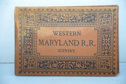
Western Maryland RR Scenery Book-1884JM Hobby Supply and Railroad Artifact Auctions4.4(127)See Sold PriceFeb 24, 2024
Great Western RY November 1, 1880 Public TimetableJM Hobby Supply and Railroad Artifact Auctions4.4(127)See Sold PriceFeb 24, 2024
19thc Colton Map, Comparitive Size of Lakes & IslandsConnoisseur Auctions3.9(336)See Sold PriceFeb 24, 2024
1849 Mitchell School ATLAS 24 MAPS America Holy Land France Africa Egypt AsiaSchilb Antiquarian Rare Books4.8(428)See Sold PriceMar 31, 2024
Pair of Early Railroad Maps - 1874 Delaware, Lackawanna & Western and 1876 Pennsylvania RailroadRail & Road Auctions4.6(165)See Sold PriceMar 07, 2024
[WORLD WAR II – OKINAWA]. Okinawa Shima Western Beaches Top...Potter & Potter Auctions4.6(545)See Sold PriceMar 07, 2024
[MAP]. NICHOLLS, Sutton (1668-1729). An Epitome of Sr. Will...Potter & Potter Auctions4.6(545)See Sold PriceMar 07, 2024
Mitchell - Map of the City of Washington (Washington, DC)Trillium Antique Prints & Rare Books4.5(32)See Sold PriceFeb 24, 2024
EARLY COLONIAL WEST AFRICA. Empires of Sokoto Gando Mas.Tribes.Fellatah 1882 mapJasper524.5(9.9k)See Sold PriceFeb 28, 2024
WEST CENTRAL AFRICA. Congo Angola Gabon Cameroon Sao Tome. MALLET 1683 old mapJasper524.5(9.9k)See Sold PriceFeb 28, 2024
Goode, George Brown 1884 Lot of 4 Natural History & Meteorology MapsAlbion Auctions4.6(341)See Sold PriceMar 01, 2024
1849 Hand Colored Blair Map of World in HemispheresMatthew Bullock Auctioneers4.7(1.8k)See Sold PriceMar 02, 2024


![1869 Mitchell Map of Western [verso] Eastern Hemispheres -- The Western Hemisphere Map No. 1… (1 of 2)](https://p1.liveauctioneers.com/5584/275309/144584413_1_x.jpg?height=282&quality=70&version=1673994422)
![1869 Mitchell Map of Western [verso] Eastern (1 of 2)](https://p1.liveauctioneers.com/5584/179610/90398453_1_x.jpg?height=282&quality=70&version=1600808901)
![1869 Mitchell Map of Western [verso] Eastern (1 of 2)](https://p1.liveauctioneers.com/5584/187575/94368539_1_x.jpg?height=282&quality=70&version=1607465981)
![1869 Mitchell Map of Western [verso] Eastern (1 of 2)](https://p1.liveauctioneers.com/5584/195010/98380725_1_x.jpg?height=282&quality=70&version=1614121450)


![[WORLD WAR II – OKINAWA]. Okinawa Shima Western Beaches Top... (1 of 1)](https://p1.liveauctioneers.com/928/318880/171361141_1_x.jpg?height=282&quality=70&version=1707501302)
![[MAP]. NICHOLLS, Sutton (1668-1729). An Epitome of Sr. Will... (1 of 1)](https://p1.liveauctioneers.com/928/318880/171361281_1_x.jpg?height=282&quality=70&version=1707501302)


![[United States]. 93 Maps (1 of 1)](https://p1.liveauctioneers.com/179/14187/4432494_1_x.jpg?height=282&quality=70&version=1193335524)