ATLAS of ANTIENT GEOGRAPHY by SAMUEL BUTLER 1843John McInnis Auctioneers,LLC4.6(502)See Sold PriceFeb 24, 2024
18TH C. ANTIQUE MAP: FRENCH & INDIAN WAR, FRAMEDThomaston Place Auction Galleries4.4(386)See Sold PriceFeb 24, 2024
Rand McNally Railroad Map Cabinet w/ 21 Railroad MapsRail & Road Auctions4.6(165)See Sold PriceMar 08, 2024
Keith Haring - Ink on New York Map, Best Buddies, Inscribed, Signed, and DatedSapphire Auction Gallery4(67)See Sold PriceMar 02, 2024
LATE 17TH C. FRENCH MAP OF THE NEW WORLD BY ALEXIS-HUBERT JAILLOT (1632-1712)Thomaston Place Auction Galleries4.4(386)See Sold PriceFeb 24, 2024
Central Railroad of New Jersey Map of Sandy Hook Route-ca. 1903JM Hobby Supply and Railroad Artifact Auctions4.4(126)See Sold PriceFeb 24, 2024
Lot of Six Mixed Atlas Box Cars-HO Scale-New in BoxJM Hobby Supply and Railroad Artifact Auctions4.4(126)See Sold PriceFeb 25, 2024
Rand McNally/Santa Fe Railroad Map of Iowa-1912JM Hobby Supply and Railroad Artifact Auctions4.4(126)See Sold PriceFeb 24, 2024
NICOLAES VISSCHER (NETHERLANDS, 1618-1709) MAP OF THE NEW WORLDThomaston Place Auction Galleries4.4(386)See Sold PriceFeb 24, 2024
17TH C. WORLD MAP BY NICOLAES VISSCHER (NETHERLANDS, 1618-1709)Thomaston Place Auction Galleries4.4(386)See Sold PriceFeb 24, 2024
Lot of Six Mixed Atlas Cabooses-HO Scale-New in BoxJM Hobby Supply and Railroad Artifact Auctions4.4(126)See Sold PriceFeb 25, 2024
Bellin: Two Maps of Tartary (Central-Northeast Asia)Title/Content of Map: Bellin: Two Maps of Tartary (Central-Northeast Asia) Date Printed: 1749/1760, Paris Cartographer: Jacques Nicolas Bellin Size: 12" x 8 1/2" (each) Bellin's highly detailed maps oSee Sold Price
Bellin: Two Maps of Tartary (Central-Northeast Asia)Bellin's highly detailed maps of Eastern and Western Tartary from Prevost d'Exiles' influential collection of travel narratives, Histoire Generale des Voyages.The upper map (Tartarie Orientale) encompSee Sold Price
Bellin: Two Maps of Tartary (Central-Northeast Asia)Bellin's highly detailed maps of Eastern and Western Tartary from Prevost d'Exiles' influential collection of travel narratives, Histoire Generale des Voyages.The upper map (Tartarie Orientale) encompSee Sold Price
Bellin: Two Maps of Tartary (Central-Northeast Asia)Map Title: 1. Carte de la Tartarie Orientale. 2. Carte de la Tartarie Occidentale Cartographer: Jacques Nicolas Bellin Place/Date: Paris / 1749/1760 Size: 12" x 8 1/2" (each) Condition: b&w; light oveSee Sold Price
Bellin: Two Maps of Tartary (Northeast & Central Asia)Title/Content of Map: Bellin: Two Maps of Tartary (Northeast & Central Asia) Date Printed: 1749/1760, Paris Cartographer: Jacques Nicolas Bellin Size: 12" x 8 1/2" (each) Bellin's highly detailed mapsSee Sold Price
Bellin: Two Maps of Tartary (Northeast & Central Asia)Title/Content of Map: Bellin: Two Maps of Tartary (Northeast & Central Asia) Date Printed: 1749/1760, Paris Cartographer: Bellin Size: 12" x 8 1/2" (each) Bellin's highly detailed maps of Eastern andSee Sold Price
Bellin: Two Maps of Tartary (Northeast & Central Asia)Title/Content of Map: Bellin: Two Maps of Tartary (Northeast & Central Asia) Date Printed: 1749/1760, Paris Cartographer: Bellin Size: 12" x 8 1/2" (each) Additional Info: Bellin's highly detailed mapSee Sold Price
Bellin: Two Maps of Tartary (Northeast & Central Asia)Title/Content of Map: Bellin: Two Maps of Tartary (Northeast & Central Asia) Date Printed: 1749/1760, Paris Cartographer: Bellin Size: 12" x 8 1/2" (each) Bellin's highly detailed maps of Eastern andSee Sold Price
Bellin: Pair of Tartary (Central-Northeast Asia) Maps1. Carte de la Tartarie Orientale. 2. Carte de la Tartarie Occidentale Bellin's highly detailed maps of Eastern and Western Tartary from Prevost d'Exiles' influential collection of travel narratives,See Sold Price
Bellin: Pair of Tartary (Central-Northeast Asia) MapsMap Title: 1. Carte de la Tartarie Orientale. 2. Carte de la Tartarie Occidentale Cartographer: Jacques Nicolas Bellin Place/Date: Paris / 1749/1760 Size: 12" x 8 1/2" (each) Condition: b&w; light oveSee Sold Price
Bellin: Pair of Tartary (Central-Northeast Asia) MapsMap Title: 1. Carte de la Tartarie Orientale. 2. Carte de la Tartarie Occidentale Cartographer: Jacques Nicolas Bellin Place/Date: Paris / 1749/1760 Size: 12" x 8 1/2" (each) Condition: b&w; light oveSee Sold Price
Bellin: Pair of Tartary (Central-Northeast Asia) MapsMap Title: 1. Carte de la Tartarie Orientale. 2. Carte de la Tartarie Occidentale Cartographer: Jacques Nicolas Bellin Place / Date: Paris / 1749/1760 Size: 12" x 8 1/2" (each) Condition: b&w; light oSee Sold Price
Bellin: Pair of Tartary (Central-Northeast Asia) MapsMap Title: 1. Carte de la Tartarie Orientale. 2. Carte de la Tartarie Occidentale Cartographer: Jacques Nicolas Bellin Place / Date: Paris / 1749/1760 Size: 12" x 8 1/2" (each) Condition: b&w; light oSee Sold Price
Bellin: Pair of Tartary (Central-Northeast Asia) MapsMap: 1. Carte de la Tartarie Orientale. 2. Carte de la Tartarie Occidentale Cartographer: Jacques Nicolas Bellin Place/Date: Paris / 1749/1760 Size: 12" x 8 1/2" (each) Condition: b&w; light overall aSee Sold Price
Bellin: Two Central Asia/Silk Road Maps, 1749Map: Two Central Asia/Silk Road Maps, "1. Carte de Karazm, Turkestan et Grande Bukarie. 2. Carte de la Petite Bukharie et Pays Voisin" Cartographer: Jacques Nicolas Bellin Place & Date: Paris / 1749/1See Sold Price
SoldTwo Framed Vintage MapsTwo framed vintage maps. One color lithograph titled "A Newe Mape of Tartary" housed in a carved wood frame and depicting the land in central Asia formerly known as Tartary. Second map is titled "FranSee Sold Price
SoldAsia.- Bellin (Jacques Nicolas) Carte des Isles duAsia.- Bellin (Jacques Nicolas) Carte des Isles du Japon,engraved map, by Schley, 220 x 300mm., central vertical fold, Paris, [c.1760]; with two other maps, showing the Philippines, Borneo, paSee Sold Price
1749 Bellin Map of Central Asia and the Caspian Sea --Title: 1749 Bellin Map of Central Asia and the Caspian Sea -- Carte de Karazm, Turkestan et Grande Bukarie … Cartographer: J Bellin Year / Place: 1749, Paris Map Dimension (in.): 8.7 X 12.2 in. ThisSee Sold Price
1749 Bellin Map of Central Asia and the Caspian Sea --Title: 1749 Bellin Map of Central Asia and the Caspian Sea -- Carte de Karazm, Turkestan et Grande Bukarie … Cartographer: J Bellin Year / Place: 1749, Paris Map Dimension (in.): 8.7 X 12.2 in. ThisSee Sold Price
SoldBellin: Antique Maps of Central Asia / Silk Road, 1749Map: 1. Carte de Karazm, Turkestan et Grande Bukarie. 2. Carte de la Petite Bukharie et Pays Voisin Cartographer: Jacques Nicolas Bellin Place & Date: Paris / 1749/1760 Size: 12" x 8 1/2" (each) CondiSee Sold Price
Moll: Antique Map of Tartary and Central Asia, 1732Title/Content of Map: 1732 Moll Map of Tartary and Central Asia -- Great Tartary. With the Tract of the Moscovite Ambassador's Travels from Moscow to Pekin in China… Date Printed: 1732, London CartoSee Sold Price
Sold1732 Moll Map of Tartary and Central Asia -- GreatTitle/Content of Map: 1732 Moll Map of Tartary and Central Asia -- Great Tartary. With the Tract of the Moscovite Ambassador's Travels from Moscow to Pekin in China… Date Printed: 1732, London CartoSee Sold Price
Moll: Antique Map of Tartary and Central Asia, 1732Title/Content of Map: 1732 Moll Map of Tartary and Central Asia -- Great Tartary. With the Tract of the Moscovite Ambassador's Travels from Moscow to Pekin in China… Date Printed: 1732, London CartoSee Sold Price
SoldWest Asia & BalkansHeading: (Asia & Balkans) Author: Title: Two maps, of central/west Asia & Balkan states Place Published: Various places Publisher: Date Published: Various dates Description:See Sold Price
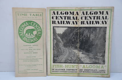
Algoma Central RY March 12, 1944 Public Timetable and BrochureJM Hobby Supply and Railroad Artifact Auctions4.4(126)See Sold PriceFeb 24, 2024
LATE 17TH C. FRENCH MAP OF THE NEW WORLD BY ALEXIS-HUBERT JAILLOT (1632-1712)Thomaston Place Auction Galleries4.4(386)See Sold PriceFeb 24, 2024
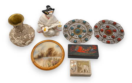
Lot of Assorted Mostly Asian Articles - Vase, etc.Direct Auction Galleries 4.7(322)See Sold PriceFeb 24, 2024
1760 MAP CARTE PARTICULIERE DE L'ISLE DE JUAN FERNANDES antique Robinson CrusoeJasper524.5(9.8k)See Sold PriceFeb 27, 2024
1764 Bellin Map of Port Antonio, Jamaica -- Plan des Havres de Port Antonio et de Saint FrancoisJasper524.5(9.8k)See Sold PriceFeb 27, 2024
Simone Samuels (American 1929-2020) macreame and carved bead necklaceRachel Davis Fine Arts4.7(476)See Sold PriceMar 02, 2024
ANTIQUE ILLUSTRATED HANDBOOK OF GEOGRAPHY AND TRAVEL IN ASIA, VOLUME 2, 1896NY Elizabeth 4.3(84)See Sold PriceMar 03, 2024