ATLAS of ANTIENT GEOGRAPHY by SAMUEL BUTLER 1843John McInnis Auctioneers,LLC4.5(505)See Sold PriceFeb 24, 2024
18TH C. ANTIQUE MAP: FRENCH & INDIAN WAR, FRAMEDThomaston Place Auction Galleries4.4(393)See Sold PriceFeb 24, 2024
Rand McNally Railroad Map Cabinet w/ 21 Railroad MapsRail & Road Auctions4.6(165)See Sold PriceMar 08, 2024
Keith Haring - Ink on New York Map, Best Buddies, Inscribed, Signed, and DatedSapphire Auction Gallery4(67)See Sold PriceMar 02, 2024
LATE 17TH C. FRENCH MAP OF THE NEW WORLD BY ALEXIS-HUBERT JAILLOT (1632-1712)Thomaston Place Auction Galleries4.4(393)See Sold PriceFeb 24, 2024
Central Railroad of New Jersey Map of Sandy Hook Route-ca. 1903JM Hobby Supply and Railroad Artifact Auctions4.4(127)See Sold PriceFeb 24, 2024
Lot of Six Mixed Atlas Box Cars-HO Scale-New in BoxJM Hobby Supply and Railroad Artifact Auctions4.4(127)See Sold PriceFeb 25, 2024
Rand McNally/Santa Fe Railroad Map of Iowa-1912JM Hobby Supply and Railroad Artifact Auctions4.4(127)See Sold PriceFeb 24, 2024
NICOLAES VISSCHER (NETHERLANDS, 1618-1709) MAP OF THE NEW WORLDThomaston Place Auction Galleries4.4(393)See Sold PriceFeb 24, 2024
17TH C. WORLD MAP BY NICOLAES VISSCHER (NETHERLANDS, 1618-1709)Thomaston Place Auction Galleries4.4(393)See Sold PriceFeb 24, 2024
Lot of Six Mixed Atlas Cabooses-HO Scale-New in BoxJM Hobby Supply and Railroad Artifact Auctions4.4(127)See Sold PriceFeb 25, 2024
SoldPHELPS & WATSON'S HISTORICAL & MILITARY MAPFramed Map, entitled 'Phelps Watson's Historical & Military Map of the Border & Southern States'. Published by Phelps & Watson, 18 Beekman Street, New York 1863, Also features a list of Battles of theSee Sold Price
SoldMap - Civil War Military, 1864, Phelps & Watson MMap, entitled 'Phelps Watson's Historical & Military Map of the Border & Southern States'. Published by Phelps & Watson, 18 Beekman Street, New York 1864. Also features a list of 'Battles of the War',See Sold Price
SoldPhelps & Watson Historical and military map of thePhelps and Watson: Historical and military map of the border and Southern states, hand-col. NY:1864Scale: 90 statue milesDimensions: 23 3/4" X 33 3/4".Note: Price 50 cents for the benefit of a One (1)See Sold Price
Phelps & Watson's Historical and Military Map of theTitle/Content of Map: Phelps & Watson's Historical and Military Map of the Border & Southern States. Cartographer: PHELPS/WATSON Date: 1863-06-29 Publisher: PHELPS & WATSON Size: 25.5Height - 35.5WidtSee Sold Price
Phelps & Watson's Historical and Military Map of theReserve Reduced! Title: Phelps & Watson's Historical and Military Map of the Border & Southern States. Publication Date: 1863-06-29 Cartographer: PHELPS/WATSON Publisher: PHELPS & WATSON Size (inches)See Sold Price
Phelps & Watson's Historical and Military Map of the Border & Southern States.Publication Date: 1865 Title: Phelps & Watson's Historical and Military Map of the Border & Southern States. Cartographer: PHELPS & WATSON Publisher: GAYLORD WATSON successor to PHELPS & WATSON HeightSee Sold Price
Phelps & Watson's Historical and Military Map of theTitle: Phelps & Watson's Historical and Military Map of the Border & Southern States. Publication Date: 1863-06-29 Cartographer: PHELPS/WATSON Publisher: PHELPS & WATSON Description: Map showing fromSee Sold Price
Phelps & Watson's Historical and Military Map of theTitle: Phelps & Watson's Historical and Military Map of the Border & Southern States. Publication Date: 1863-06-29 Publisher: PHELPS & WATSON Size: 25.5 x 35.5 Map pshowing from PA to NE and south witSee Sold Price
Decorative Historic Civil War Large Pocket Map.Phelps & Watson (fl. 1860's). Phelps & Watson's Historical and Military Map of the Border & Southern States. Lithographed map with orignal hand color. Phelps & Watson, 1863. 25½" x 35½" Map showSee Sold Price
Decorative Historical Civil War Large Pocket MapPhelps & Watson (fl. 1860's). Phelps & Watson's Historical and Military Map of the Border & Southern States. Lithographed map. Phelps & Watson, 1863. 25½ x 35½" sheet. Map showing from PA to NESee Sold Price
SoldAntique Civil War Military MapPhelps and Watsons Historical and Military Map of the Border of the Southern States. Published by Phelps & Watson, 18 Beekman Street, New York 1864. The piece gives very interesting and detailed inforSee Sold Price
SoldHistorical Military Map by Phelps & WatsonHistorical Military Map by Phelps & WatsonSee Sold Price
SoldAntique Map, Phelps & Watson (NY), 1861,Antique Map, Phelps & Watson (NY), 1861,showing the United States, Mexico, Central America, and West Indies, backed w/linen, varnished and mounted to two rollers for hanging, engraved vignettes througSee Sold Price
SoldROLL DOWN PICTORIAL MAP US OF AMERICA 1860 PHELPS &ROLL DOWN PICTORIAL MAP US OF AMERICA 1860 PHELPS & WATSON 1860, NEW YORK. USUAL SCUFFS AND SOME SEPARATION. MEASURES APPROX. 35" X 44". SOME DAMAGE ON TOP EDGE.See Sold Price
SoldGERMAN MILITARY MAP OF MANCHESTERGERMAN MILITARY MAP OF MANCHESTER Printed 1:10,000-scale map, 19 1/2" x 28 1/4", a map of the English city of Manchester produced by the Wehrmacht, with the latest update being made in March of 1942.See Sold Price
SoldEight Coffee Table Books, Military & Map MakingEight Coffee Table Books, Military & Map Making: Map Makers Art, War Maps, Historical Atlas of the US Navy, Liberty, History of Cavalry, The Boer War, Napoleons Army, Victorian Colonial Warfare. (25-5See Sold Price
SoldWORLD WAR II MARINES HISTORICAL MILITARY BUGLE ETCUnited States Marines World War II Military Used Brass Bugle. Along with a Camoflauge Hat with Emblem. Ephemera Including a Theatre Map of Asiatic Pacific, American, European African Middle Eastern TeSee Sold Price
SoldCIVIL WAR HISTORICAL REPRODUCTION PRINTCIVIL WAR HISTORICAL REPRODUCTION PRINT, lithograph on laid paper, titled "Extract of Military Map of N.E. Virginia; Showing Forts and Roads' Engineer Bureau War Dept., 1865", featuring a detailed mapSee Sold Price
SoldMILITARY MAP OF SOUTH ENGLAND, OWNED BY GEN. HUEBNERGreat condition military map of south England, 32.5 x 24.75 in., scale 1:253,440, published by the Ordinance Survey of Great Britain, ca. 1940. The top margin bears the title 'ENGLAND, SOUTH.', the diSee Sold Price
MILITARY MAPS OF NORTH WEST EUROPE, BELGIUM AND FRANCEGood lot of four military maps includes: a map of North West Europe Sheet 1 & part of 4 published Feb. 1915 by the War Office approx. 29 x 33.5 in. scale 1:250 000 fine condition; a map of France SheeSee Sold Price
GERMAN MILITARY MAP WITH LETTERED QUADRANTSGERMAN MILITARY MAP WITH LETTERED QUADRANTS War-date printed German naval map, 31" x 23", Paris, 1943, showing the area of Brest and the immediate waters offshore broken into quadrants, reminiscent ofSee Sold Price
Pair of 1861 Historical MAPS Taken fromPair of 1861 Historical MAPS Taken from the Johnson & Browing Atlas 18 x 24 "New Military Map of the United States" showing Forts, Military Posts & Military divisions plus 131/2 x 161/2 Map of NebraskSee Sold Price
SoldAMERICAN HISTORICAL MILITARY VOLUMES, SET OF THREEAMERICAN HISTORICAL MILITARY VOLUMES, SET OF THREE Winfield Scott, "Infantry Tactics, or Rules for the Exercise and Maneuvers of the United States Infantry", 1859, New Edition, Harper & Brothers, NewSee Sold Price
SoldMAJ. GEN. HAROLD W. BLAKELEY'S MILITARY MAPS (6)Great lot of six military maps owned and likely field-used by U.S. Army Maj. Gen. HAROLD W. BLAKELEY (1893 - 1966), commander of the 4th Infantry Division Artillery at the time of Operation Overlord.See Sold Price
1875 Rand Avery and Co. Map of Express Companies and Railroads of the USA and CanadaJM Hobby Supply and Railroad Artifact Auctions4.4(127)See Sold PriceFeb 24, 2024
CHARLES ROLLIN c1828 Ceasar Hand Colored Africa Military MapLuis Porretta Fine Arts4.3(10)See Sold PriceMar 02, 2024
Egyptian Limestone Relief with Bound Asiatic CaptiveTimeLine Auctions Ltd.4.6(183)See Sold PriceMar 06, 2024
Group of Ten Railroad Photographs, Maps, and Prints - New Jersey, Long Island, and New YorkRail & Road Auctions4.6(165)See Sold PriceMar 07, 2024
Collection of Allied Military Silk Printed Maps, WWII Era and LaterMaterial Culture4.6(778)See Sold PriceFeb 29, 2024
The Complete History of World War II 1948North American Artifact Auctions4.7(198)See Sold PriceApr 20, 2024
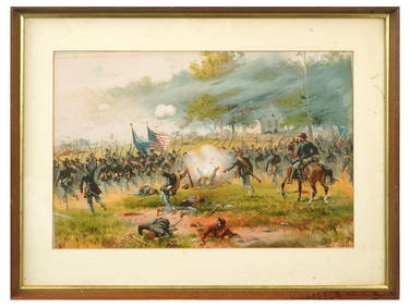
ANTIQUE AMERICAN CIVIL WAR LITHO BY THURE DE THULSTRUPAntique Arena Inc.4.5(878)See Sold PriceFeb 24, 2024
ANTIQUE AMERICAN CIVIL WAR LITHO BY THURE DE THULSTRUPAntique Arena Inc.4.5(878)See Sold PriceFeb 24, 2024
ANTIQUE AMERICAN CIVIL WAR LITHO BY THURE DE THULSTRUPAntique Arena Inc.4.5(878)See Sold PriceFeb 24, 2024
Geographical, Statistical, and Historical Map of the Leeward Islands.Jasper524.5(9.9k)See Sold PriceFeb 27, 2024
Geographical Statistical and Historical Map of the Windward IslandsJasper524.5(9.9k)See Sold PriceFeb 27, 2024
Geographical, Statistical, and Historical Map of the West Indies.Jasper524.5(9.9k)See Sold PriceFeb 27, 2024
World War 2 Europe Battle of the Atlantic 1939-43 Axis Expansion limits 1959 mapJasper524.5(9.9k)See Sold PriceFeb 28, 2024
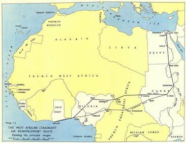
West Africa WW2 Nigeria Sudan Egypt. Takoradi air reinforcement route 1954 mapJasper524.5(9.9k)See Sold PriceFeb 28, 2024
Operation Torch Nov 1942-May 1943. World War 2. Western Mediterranean 1966 mapJasper524.5(9.9k)See Sold PriceFeb 28, 2024
Antique "Magic Lantern" Glass Educational SlidesRapid Estate Liquidators and Auction Gallery4.5(1.1k)See Sold PriceFeb 25, 2024
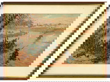
Jean-Baptiste de Silva (1682 - 1742) - Antique Steel Engraving - Bataillon où l'on voitProverde Auctions4.3(3)See Sold PriceFeb 28, 2024
George F. Cram - Historical Map of Pittsburgh Allegheny PennsylvaniaProverde Auctions4.3(3)See Sold PriceFeb 28, 2024