ATLAS of ANTIENT GEOGRAPHY by SAMUEL BUTLER 1843John McInnis Auctioneers,LLC4.6(502)See Sold PriceFeb 24, 2024
18TH C. ANTIQUE MAP: FRENCH & INDIAN WAR, FRAMEDThomaston Place Auction Galleries4.4(386)See Sold PriceFeb 24, 2024
Rand McNally Railroad Map Cabinet w/ 21 Railroad MapsRail & Road Auctions4.6(165)See Sold PriceMar 08, 2024
Keith Haring - Ink on New York Map, Best Buddies, Inscribed, Signed, and DatedSapphire Auction Gallery4(67)See Sold PriceMar 02, 2024
LATE 17TH C. FRENCH MAP OF THE NEW WORLD BY ALEXIS-HUBERT JAILLOT (1632-1712)Thomaston Place Auction Galleries4.4(386)See Sold PriceFeb 24, 2024
Central Railroad of New Jersey Map of Sandy Hook Route-ca. 1903JM Hobby Supply and Railroad Artifact Auctions4.4(126)See Sold PriceFeb 24, 2024
Lot of Six Mixed Atlas Box Cars-HO Scale-New in BoxJM Hobby Supply and Railroad Artifact Auctions4.4(126)See Sold PriceFeb 25, 2024
Rand McNally/Santa Fe Railroad Map of Iowa-1912JM Hobby Supply and Railroad Artifact Auctions4.4(126)See Sold PriceFeb 24, 2024
NICOLAES VISSCHER (NETHERLANDS, 1618-1709) MAP OF THE NEW WORLDThomaston Place Auction Galleries4.4(386)See Sold PriceFeb 24, 2024
17TH C. WORLD MAP BY NICOLAES VISSCHER (NETHERLANDS, 1618-1709)Thomaston Place Auction Galleries4.4(386)See Sold PriceFeb 24, 2024
Lot of Six Mixed Atlas Cabooses-HO Scale-New in BoxJM Hobby Supply and Railroad Artifact Auctions4.4(126)See Sold PriceFeb 25, 2024
1776 Map of Ancient BritainAuthor: Lodge Title: 1776 Map of Ancient Britain Medium: Ink on Paper Dimensions: 12"X11" Description: Map of Ancient Britain dated 1766. Engraved by J. Lodge and published by London. Captures BritainSee Sold Price
1776 Map of Ancient BritainAuthor: Lodge Title: 1776 Map of Ancient Britain Medium: Ink on Paper Dimensions: 12"X11" Map of Ancient Britain dated 1766. Engraved by J. Lodge and published by London. Captures Britain under RomanSee Sold Price
1776 Map of Ancient BritainAuthor: Lodge Title: 1776 Map of Ancient Britain Medium: Ink on Paper Dimensions: 12"X11" Map of Ancient Britain dated 1766. Engraved by J. Lodge and published by London. Captures Britain under RomanSee Sold Price
SoldLot of 2 Published maps. Ancient Britain. A Map ofLot of 2 Published maps. Ancient Britain. A Map of the Major Visible Antiquities of Great Britain Older than AD 1066. Published by the Director General of the Ordinance Survey. Chessinton, Surrey. 195See Sold Price
Ancient Britain ITitle/Content of Map: Ancient Britain I Publication Date: 1852-01-01 Cartographer: Publisher: S.D.U.K. Charles Knight Description: Published under the superintendence of the Society for the DiffusionSee Sold Price
Ancient Britain IITitle/Content of Map: Ancient Britain II Publication Date: 1852-01-01 Cartographer: Publisher: S.D.U.K. Charles Knight Description: Published under the superintendence of the Society for the DiffusionSee Sold Price
ANCIENT BRITAIN.Caledonia-Scotland.Roman road townReserve Reduced! TITLE/CONTENT OF MAP: 'ANCIENT BRITAIN, II (Caledonia - Scotland)' DATE PRINTED: This map was originally published by Baldwin & Cradock in 1834; this date is printed on the map. ThisSee Sold Price
ANCIENT BRITAIN.Caledonia-Scotland.Roman road townTITLE/CONTENT OF MAP: 'ANCIENT BRITAIN, II (Caledonia - Scotland)' The top image on the right hand side shows the entire map. To view a close up of the map showing the level of printed detail, pleaseSee Sold Price
SoldA handpainted map of ancient Britain, on parchment withA handpainted map of ancient Britain, on parchment with fine calligraphy, having latin titles and key grid, enclosed in oak frame with gilt slip. (19in x 21in)See Sold Price
Mallet: Antique Map of Ancient Britain, 1683Title/Content of the Map: 'Heptarchie des Saxons' England. Wales and parts of Scotland and of Ireland. ANCIENT BRITAIN. Anglo-Saxon Kingdoms. Date Printed: 1683 Image Size: Approx Overall page size 13See Sold Price
Mallet: Antique Map of Ancient Britain, 1683Title/Content of Map: 'Heptarchie des Saxons' ANCIENT BRITAIN. Anglo-Saxon Kingdoms. England. Wales and parts of Scotland and of Ireland. Date Printed: 1683 Image Size: Approx Overall page size 13 x 2See Sold Price
Sold1828 Map of Ancient BritainAuthor: Hall Title: 1828 Map of Ancient Britain Medium: Ink on Paper Dimensions: 8.5"X10.5" Map of Ancient Britain dated 1828. Part of Butler's Antique World Atlas. Drawn and engraved by Sydney Hall.See Sold Price
1828 Map of Ancient BritainAuthor: Hall Title: 1828 Map of Ancient Britain Medium: Ink on Paper Dimensions: 8.5"X10.5" Map of Ancient Britain dated 1828. Part of Butler's Antique World Atlas. Drawn and engraved by Sydney Hall.See Sold Price
Map of Ancient BritainHeading: (Great Britain) Author: De Vaugondy, Robert Title: Britannicae Insulae in quibus Albion seu Britannia Major et Ivernia seu Britannia Minor… Place Published: Paris Publisher: Date PublishSee Sold Price
1766 Map of Ancient BritainAuthor: Lodge Title: 1766 Map of Ancient Britain Medium: Ink on Paper Dimensions: 12"X11" Map of Ancient Britain dated 1766. Engraved by J. Lodge and published by London. Captures Britain under RomanSee Sold Price
Sold1801 Map of BritainAuthor: Hall Title: 1801 Map of Britain Medium: Ink on Paper Dimensions: 8.5"X10.5" Description: Map of Ancient Britain dated 1801. Part of the Atlas of Ancient Geography by Samuel Butler. Engraved bySee Sold Price
SoldBritish Isles.- Ortelius (Abraham) BritannicarumBritish Isles.- Ortelius (Abraham) Britannicarum Insularum Vetus Descriptio, two-sheet map of ancient Britain, probably engraved by Jan Wierix, with four ornate strap-work cartouches, a naval battle iSee Sold Price
1801 Map of BritainAuthor: Hall Title: 1801 Map of Britain Medium: Ink on Paper Dimensions: 8.5"X10.5" Map of Ancient Britain dated 1801. Part of the Atlas of Ancient Geography by Samuel Butler. Engraved by S. Hall. PubSee Sold Price
Insularum Britannicarum Facies AntiquaTitle/Content of Map: Insularum Britannicarum Facies Antiqua Date: 1774 Cartographer: CELLARIUS, CHRISTOPHORUS (1638-1707) Size: 11.8X17.75 Map of ancient Britain and Ireland in Roman times. Plate VI.See Sold Price
Insularum Britannicarum Facies AntiquaTitle: Insularum Britannicarum Facies Antiqua Cartographer: CELLARIUS, CHRISTOPHORUS (1638-1707) Publisher: J.B. GHISI Height: 11.8 Width: 17.75 Map of ancient Britain and Ireland in Roman times. PlatSee Sold Price
Insularum Britannicarum Facies AntiquaPublication Date: 1774 Title: Insularum Britannicarum Facies Antiqua Cartographer: CELLARIUS, CHRISTOPHORUS (1638-1707) Publisher: J.B. GHISI Height: 11.8 Width: 17.75 Map of ancient Britain and IrelaSee Sold Price
Maps C1875 Lot of 8 From the National EncyclopediaIncl Plymouth Sound, Manchester Ship Canal, Charlemagne Empire, Carlovingian Empire, Europe, England and Wales, Suez Canal, and Ancient Britain. Lithograph Maps Published C1868-81 by William MackenzieSee Sold Price
Maps C1875 Lot of 8 From the National EncyclopediaIncl Plymouth Sound, Manchester Ship Canal, Charlemagne Empire, Carlovingian Empire, Europe, England and Wales, Suez Canal, and Ancient Britain. Lithograph Maps Published C1868-81 by William MackenzieSee Sold Price
Sold1640 Blaeu Brittania Anglo-Saxonum Hand Colored MapComes with a certificate from Paulus Swaen Old Maps & Prints. Map depicts the ancient kingdoms of Britain, with 2 side panels. The left depicts the founders of the 7 Anglo-Saxon kingdoms, right showsSee Sold Price
Archaeological Books - Douglas - Nenia Britannica or, an Account of Some Hundred Sepulchres, of theTimeLine Auctions Ltd.4.5(183)See Sold PriceMar 06, 2024
Archaeological Books - Douglas - Nenia Britannica or, an Account of Some Hundred Sepulchres, of theTimeLine Auctions Ltd.4.5(183)See Sold PriceMar 06, 2024
General Books - Four Maps of Great Britain Designed by Matthew Paris About A.D. 1250TimeLine Auctions Ltd.4.5(183)See Sold PriceMar 08, 2024
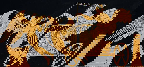
Hamilton - Engraving of a Painting from a Grecian Vase. 1Trillium Antique Prints & Rare Books4.5(30)See Sold PriceFeb 24, 2024
Hamilton - Engraving of a Painting from a Grecian VaseTrillium Antique Prints & Rare Books4.5(30)See Sold PriceFeb 24, 2024
Hamilton - Engraving of a Painting from a Grecian Vase. 2Trillium Antique Prints & Rare Books4.5(30)See Sold PriceFeb 24, 2024
Hamilton - Engraving of a Painting from a Grecian Vase. 32Trillium Antique Prints & Rare Books4.5(30)See Sold PriceFeb 24, 2024
Hamilton - Engraving of a Painting from a Grecian Vase. 114Trillium Antique Prints & Rare Books4.5(30)See Sold PriceFeb 24, 2024
Hamilton - Engraving of a Painting from a Grecian Vase. 5Trillium Antique Prints & Rare Books4.5(30)See Sold PriceFeb 24, 2024
1860 PICTORIAL BOOK of ANCIENT BALLADS of GREAT BRITAIN antique ILLUSTRATEDJasper524.5(9.8k)See Sold PriceFeb 27, 2024
Afrique Ancienne. Ancient North Africa. MALTE-BRUN c1871 old antique map chartJasper524.5(9.8k)See Sold PriceFeb 28, 2024
1776 Great Britain Gold Guinea George III AU-58 NGCPacific Global Auction3.9(272)See Sold PriceFeb 26, 2024
Georg Bockler Map of Ancient Jerulsaem EtchingAuctions at Showplace4.5(726)See Sold PriceApr 07, 2024
Ancient Chinese landscape map of Ma Yuan on silkJapan Ancient Art Co. LTD4.4(37)See Sold PriceFeb 28, 2024
Rees & Macpherson 1820 Lot of 6 Ancient Geography MapsAlbion Auctions4.6(336)See Sold PriceMar 01, 2024
1776 Great Britain Gold Guinea George III AU-58 NGCGolden Air Auctions4.4(257)See Sold PriceFeb 28, 2024