ATLAS of ANTIENT GEOGRAPHY by SAMUEL BUTLER 1843John McInnis Auctioneers,LLC4.5(505)See Sold PriceFeb 24, 2024
18TH C. ANTIQUE MAP: FRENCH & INDIAN WAR, FRAMEDThomaston Place Auction Galleries4.4(394)See Sold PriceFeb 24, 2024
Rand McNally Railroad Map Cabinet w/ 21 Railroad MapsRail & Road Auctions4.6(165)See Sold PriceMar 08, 2024
Keith Haring - Ink on New York Map, Best Buddies, Inscribed, Signed, and DatedSapphire Auction Gallery4.1(67)See Sold PriceMar 02, 2024
LATE 17TH C. FRENCH MAP OF THE NEW WORLD BY ALEXIS-HUBERT JAILLOT (1632-1712)Thomaston Place Auction Galleries4.4(394)See Sold PriceFeb 24, 2024
Central Railroad of New Jersey Map of Sandy Hook Route-ca. 1903JM Hobby Supply and Railroad Artifact Auctions4.4(127)See Sold PriceFeb 24, 2024
Lot of Six Mixed Atlas Box Cars-HO Scale-New in BoxJM Hobby Supply and Railroad Artifact Auctions4.4(127)See Sold PriceFeb 25, 2024
Rand McNally/Santa Fe Railroad Map of Iowa-1912JM Hobby Supply and Railroad Artifact Auctions4.4(127)See Sold PriceFeb 24, 2024
NICOLAES VISSCHER (NETHERLANDS, 1618-1709) MAP OF THE NEW WORLDThomaston Place Auction Galleries4.4(394)See Sold PriceFeb 24, 2024
17TH C. WORLD MAP BY NICOLAES VISSCHER (NETHERLANDS, 1618-1709)Thomaston Place Auction Galleries4.4(394)See Sold PriceFeb 24, 2024
Lot of Six Mixed Atlas Cabooses-HO Scale-New in BoxJM Hobby Supply and Railroad Artifact Auctions4.4(127)See Sold PriceFeb 25, 2024
Quenn Milling and Mining maps (112341)Four maps for the Queen Mining and Milling property Elmore County Idaho. Original pen and and ink on paper. Survey J.L. McPherson 1926. Three other smaller maps meant for illustrations in a report. A)See Sold Price
Quenn Milling and Mining maps (112341)Four maps for the Queen Mining and Milling property Elmore County Idaho. Original pen and and ink on paper. Survey J.L. McPherson 1926. Three other smaller maps meant for illustrations in a report. A)See Sold Price
Queen Milling and Mining maps (112341)Four maps for the Queen Mining and Milling property Elmore County Idaho. Original pen and ink on paper. Survey J.L. McPherson 1926. Three other smaller maps meant for illustrations in a report. A) plaSee Sold Price
SoldMining Prospectuses (112061)Lot of two: 1) Index Mining Co., Index, Washington. 26 pages, 4 x 6 inch pamphlet with photos and folded claim map, 1899. 2) King Copper Mining & Milling Co. Mines Located in the Miller River DistrictSee Sold Price
SoldSanta Ysabel Mining & Milling Co. ProspectusDescription:4 pp. Illustrations from photographs; map. 8x10, original stiff paper wrappers lettered in gilt, photo illustration tipped to front cover. Prospectus for mining operations in Tuolumne CounSee Sold Price
SoldRare 1901 Tonopah Prospectus With Claim Map (111984)Prospectus from the United Randolph Mining & Milling Company which operated at Tonopah, Nevada with offices at Randsburg, Cal. The company's mine was located 1 1/4 miles east of the famous Mizpah lodeSee Sold Price
SoldSquare Deal Mining, Milling, Drainage Tunnel &Frisco, Summit County. Very rare and unique style mining stock. Vignette photos of the mine and machinery incorporated into the border. Orange underprint map.No. 2144, issued for 6,500 shares to WilliSee Sold Price
Square Deal Mining, Milling, Drainage Tunnel &Located at Frisco, Summit County. Very rare and unique style mining stock that includes photo vignettes of the mine and machinery incorporated into the border and an orange underprint map! No. 2005, iSee Sold Price
The Square Deal Mining, Milling, Drainage Tunnel &Frisco, Summit County. Very rare and unique style mining stock. Vignette photos of the mine and machinery incorporated into the border. Orange underprint map.No. 2144, issued for 6,500 shares to WilliSee Sold Price
Durango mine ephemera (84620)1. Durango Mining, Milling and Exploration Co, organized under he laws of the State of Maine, prospectus and annual report for the year 1910. Prospectus is 14 pages with maps of the various holdings iSee Sold Price
Durango mine ephemera (84620)1. Durango Mining, Milling and Exploration Co, organized under he laws of the State of Maine, prospectus and annual report for the year 1910. Prospectus is 14 pages with maps of the various holdings iSee Sold Price
Durango mine ephemera (84620)1. Durango Mining, Milling and Exploration Co, organized under he laws of the State of Maine, prospectus and annual report for the year 1910. Prospectus is 14 pages with maps of the various holdings iSee Sold Price
Durango mine ephemera #846201. Durango Mining, Milling and Exploration Co, organized under he laws of the State of Maine, prospectus and annual report for the year 1910. Prospectus is 14 pages with maps of the various holdings iSee Sold Price
SoldEdina Mining and Milling Co. Prospectus, Creede, CO,Prospectus. 12 pp. Five photos and a map showing all the principal mines on Bachelor Hill with the "Edina" group being the most prominent. Inserted is a blank form for ordering stock dated 189_. The pSee Sold Price
Sold1926 Jefferson County Montana Mining Map RAREThis is an original 1926 Jefferson County, Montana mining map. The map shows part of the Cataract and High Ore Mining Districts. The mining claims owned or controlled by the Basin Montana Tunnel CompaSee Sold Price
SoldTWO OLD VINTAGE MINING MAPSTWO OLD VINTAGE MINING MAPS. 1931 MAP OF THE MAYFLOWER MINES NEVADA CITY MINING DISTRICT. THIS MAP IS ON LINEN PAPER. WRITING AND DRAWING EXISTS ON ONE MAP. 1936 MAP OF THE SOUTHEASTERLY GRASS VALEY-NSee Sold Price
SoldNEVADA CITY GOLD MINING MAPSTWO OLD GOLD MINING MAPS. 1948THE GRACIE MINE - NEVADA CITY CALIF - PAPER AND LINEN, OLD MAP DEPICTING WHERE CERTAIN GROUPS WERE DIGGING. MONARCH GROUP, BULLION GROUP, PHOENIX GROUP, BUTCHER RANCH GROSee Sold Price
SoldRare mining map of Pacific Northwest.Heading: Author: Amerine, C. H. Title: Map of the Different Mining Countries of the Northwest / Map of Washington with Adjacent Parts of British Columbia, Montana and Idaho Place Published: Spokane FSee Sold Price
SoldLarge mining map of Prescott region, ArizonaHeading: Author: Baumann, Jules Title: Prescott and Tributary Mining Districts, Yavapai County, Arizona Place Published: No place Publisher: Date Published: 1895 Description:See Sold Price
Scarce mining map of Gilpin Co. ColoradoHeading: (Colorado) Author: Title: Mining Map of Northern Gilpin County Colorado Place Published: Denver Publisher:Clason Map Co. Date Published: 1916 Description: Blue-line mapSee Sold Price
Large lot of Mining Maps, Prints, Articles, etc.Looking for historical research documents. This lot of nineteen includes: 1) Mining map of Yavapai County 1900. Original. 2) La Colorado workings 3) Mine disaster in Lancashire print. 4) Goldsmith BroSee Sold Price
SoldIdaho Territorial Mining Maps & Letter Sheet - Boise,c1883 Lot of 3: 2 are mining map of the Boise and southwestern Caldwell mining districts. The Boise map appears to be hand-drawn and colorized, quite unique. The Caldwell area map is dated 1883, and hSee Sold Price
JOHN FULTON Coke Coal Mining Rare c1895 1st Edition TreatiseLuis Porretta Fine Arts4.3(10)See Sold PriceMar 02, 2024
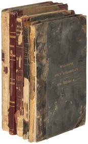
1885 CIVIL WAR 1ed Famous Memoirs US Grant Sheridan Sherman 6v RARE LOT MapsSchilb Antiquarian Rare Books4.8(431)See Sold PriceMar 10, 2024
Large lot of assorted prints. 18th-20th century. To include: North American and other maps, CivilTremont Auctions4.5(298)See Sold PriceFeb 25, 2024
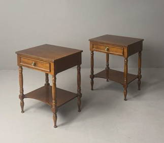
Pair Baker Milling Road Nightstands EndtablesEpic Auctions and Estate Sales4.6(210)See Sold PriceMar 02, 2024
Collection of Allied Military Silk Printed Maps, WWII Era and LaterMaterial Culture4.6(780)See Sold PriceFeb 29, 2024
Rand McNally Railroad Map Cabinet w/ 21 Railroad MapsRail & Road Auctions4.6(165)See Sold PriceMar 08, 2024
Willem Blaeu, Etc. 17th C. Antiquarian Maps, 2Auctions at Showplace4.6(744)See Sold PriceMar 17, 2024
Putnam - First Map of the State of Ohio by Rufus PutnamTrillium Antique Prints & Rare Books4.5(33)See Sold PriceFeb 24, 2024
De Jode, Rare, pub. 1593 - Map of Africa (Africae Vera Forma, et Situs)Trillium Antique Prints & Rare Books4.5(33)See Sold PriceFeb 24, 2024