ATLAS of ANTIENT GEOGRAPHY by SAMUEL BUTLER 1843John McInnis Auctioneers,LLC4.6(504)See Sold PriceFeb 24, 2024
18TH C. ANTIQUE MAP: FRENCH & INDIAN WAR, FRAMEDThomaston Place Auction Galleries4.4(389)See Sold PriceFeb 24, 2024
Rand McNally Railroad Map Cabinet w/ 21 Railroad MapsRail & Road Auctions4.6(165)See Sold PriceMar 08, 2024
Keith Haring - Ink on New York Map, Best Buddies, Inscribed, Signed, and DatedSapphire Auction GallerySee Sold PriceMar 02, 2024
LATE 17TH C. FRENCH MAP OF THE NEW WORLD BY ALEXIS-HUBERT JAILLOT (1632-1712)Thomaston Place Auction Galleries4.4(389)See Sold PriceFeb 24, 2024
Central Railroad of New Jersey Map of Sandy Hook Route-ca. 1903JM Hobby Supply and Railroad Artifact Auctions4.4(126)See Sold PriceFeb 24, 2024
Lot of Six Mixed Atlas Box Cars-HO Scale-New in BoxJM Hobby Supply and Railroad Artifact Auctions4.4(126)See Sold PriceFeb 25, 2024
Rand McNally/Santa Fe Railroad Map of Iowa-1912JM Hobby Supply and Railroad Artifact Auctions4.4(126)See Sold PriceFeb 24, 2024
NICOLAES VISSCHER (NETHERLANDS, 1618-1709) MAP OF THE NEW WORLDThomaston Place Auction Galleries4.4(389)See Sold PriceFeb 24, 2024
17TH C. WORLD MAP BY NICOLAES VISSCHER (NETHERLANDS, 1618-1709)Thomaston Place Auction Galleries4.4(389)See Sold PriceFeb 24, 2024
Lot of Six Mixed Atlas Cabooses-HO Scale-New in BoxJM Hobby Supply and Railroad Artifact Auctions4.4(126)See Sold PriceFeb 25, 2024
1899 Map of Cuba and the BahamasAuthor: Title: 1899 Map of Cuba and the Bahamas Medium: Ink on Paper Dimensions: 14.5"X12" Description: Map of Cuba and the Bahamas Islands dated 1899. Part of the 1899 in the National Standard AtlasSee Sold Price
1899 Map of Cuba and the BahamasTitle: 1899 Map of Cuba and the Bahamas Medium: Ink on Paper Dimensions: 14.5"X12" Map of Cuba and the Bahamas Islands dated 1899. Rather rare. Part of the 1899 in the National Standard Atlas of the WSee Sold Price
1899 Map of Cuba and the BahamasTitle: 1899 Map of Cuba and the Bahamas Medium: Ink on Paper Dimensions: 14.5"X12" Map of Cuba and the Bahamas Islands dated 1899. Rather rare. Part of the 1899 National Standard Atlas of the World. PSee Sold Price
1899 Map of CubaAuthor: Miller Title: 1899 Map of Cuba Medium: Ink on paper Dimensions: 22.5"X16" Map of Cuba dated 1889. Map key located upper right and lower right. Huge inset of the West Indies lower left. Small iSee Sold Price
1899 Map of Cuba and the BahamasAuthor: Title: 1899 Map of Cuba and the Bahamas Medium: Ink on Paper Dimensions: 14.5"X12" Description: Map of Cuba and the Bahamas Islands dated 1899. Rather rare. Part of the 1899 in the National StSee Sold Price
1899 Map of Cuba and the Bahamas IslandsTitle: 1899 Map of Cuba and the Bahamas Islands Medium: Ink on Paper Dimensions: 14.5"X12" Map of Cuba and the Bahamas Islands dated 1899. Rather rare. Part of the 1899 in the National Standard AtlasSee Sold Price
1899 Map of CubaTitle: 1899 Map of Cuba Medium: Ink on Paper Dimensions: 22.5"X16" Map of Cuba dated 1889. Double folio map. Key located upper right and lower right. Huge inset of the West Indies lower left. Small inSee Sold Price
1899 Map of CubaAuthor: Miller Title: 1899 Map of Cuba Medium: Ink on Paper Dimensions: 22.5"X16" Map of Cuba dated 1889. Double folio map. Key located upper right and lower right. Huge inset of the West Indies lowerSee Sold Price
1899 Map of Cuba and BahamasTitle: 1899 Map of Cuba and Bahamas Author: Medium: Ink on paper Dimensions: 14.5"X12" Description: Map of Cuba and the Bahamas Islands dated 1899. Rather rare. Part of the 1899 in the National StandaSee Sold Price
1899 Map of Cuba and the BahamasAuthor: Title: 1899 Map of Cuba and the Bahamas Medium: Ink on Paper Dimensions: 14.5"X12" Map of Cuba and the Bahamas Islands dated 1899. Rather rare. Part of the 1899 in the National Standard AtlasSee Sold Price
1899 Map West Indies and CubaTitle: 1899 Map West Indies and Cuba Medium: Ink on Paper Dimensions: 13.5"X10.5" Map of West Indies and Cuba dated 1899. Published in Buffalo, New York by Matthews-Northrup. Detailed dated key for boSee Sold Price
Sold1899 Map of West Indies and CubaAuthor: Matthews Title: 1899 Map of West Indies and Cuba Medium: Ink on Paper Dimensions: 13.5"X10.5" Map of West Indies and Cuba dated 1899. Published in Buffalo, New York by Matthews-Northrup. DetaiSee Sold Price
1899 Map of West Indies and CubaAuthor: Matthews Title: 1899 Map of West Indies and Cuba Medium: Ink on paper Dimensions: 13.5"X10.5" Map of West Indies and Cuba dated 1899. Published in Buffalo, New York by Matthews-Northrup. DetaiSee Sold Price
Barber: Cuba, 1899Map: Cuba. Engraved especially for this publication from latest surveys. Cartographer: Barber Place & Date: Chicago / 1899 Size: 6 1/2" x 5" Condition: colored lithograph; overall age toning A SpanishSee Sold Price
SoldBarber: Cuba, 1899Map Title: Cuba. Engraved especially for this publication from latest surveys. Cartographer: Barber Place/Date: Chicago / 1899 Size: 6 1/2" x 5" Condition: colored lithograph; overall age toning A SpaSee Sold Price
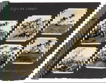
Lot of Five 19th-cent. Scenic Views of Rural CubaTitle/Content of Map: Lot of Five 19th-cent. Scenic Views of Rural Cuba Date Printed: 1869–1899, Chicago, Madrid, Paris, London Five beautifully rendered scenes of the Cuban countryside in the 2nd hSee Sold Price
SoldLot of Five 19th-cent. Scenic Views of Rural CubaTitle/Content of Map: Lot of Five 19th-cent. Scenic Views of Rural Cuba Date Printed: 1869–1899, Chicago, Madrid, Paris, London Cartographer: Five beautifully rendered scenes of the Cuban countrysidSee Sold Price
Map of U.S. and its New Possessions, 1899Heading: (United States) Author: Title: The United States and its new possessions: Puerto Rico, Cuba, Hawaii, Philippine Islands and Alaska, with general maps of Europe, Asia, Africa and Pan AmericaSee Sold Price
SoldMap of U.S. and its New Possessions, 1899Heading: (United States) Author: Title: The United States and its new possessions: Puerto Rico, Cuba, Hawaii, Philippine Islands and Alaska, with general maps of Europe, Asia, Africa and Pan AmericaSee Sold Price
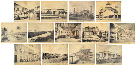
SoldGuide to Havana and Vicinity w/map 1899Heading: (Cuba - Havana ) Author: Menendez, Antonio E. Title: Guide to Havana and Vicinity Place Published: Havana, Cuba Publisher:M. Ricoy Date Published: 1899 Description:See Sold Price
SoldMercator / Hondius: Antique Map Cuba / Hispaniola, 1607Title/Content of Map: Cuba Insul/Hispaniola Cartographer: Mercator / Hondius Place & Date: Amsterdam / 1607/1620s Size: 7 1/8" x 5 5/8" Condition: full color; overall age-toning and some staining; resSee Sold Price
SoldTROOP I 2ND CAVALRY 1899 CUBA ETCHED SWORD BELTDeployed with Roosevelt in Cuba during Spanish American War, back of buckle etched, Rock Island Arsenal stamped belt, very good condition.See Sold Price
SoldDated 1899 MapDated 1899 (Central School Supply House Chicago) topographical map. 34 1/4" x 47 1/2" Overall.See Sold Price
Sold1899 Map of LousianaAuthor: Matthews Title: 1899 Map of Lousiana Medium: Ink on Paper Dimensions: 13.5"X11" Map of Louisiana dated 1899. Published by the Matthews Northrup Co. in Buffalo. With extensive dated population,See Sold Price
Cincinnati Hamilton and Dayton RR Map -USGC 1889JM Hobby Supply and Railroad Artifact Auctions4.4(126)See Sold PriceFeb 24, 2024
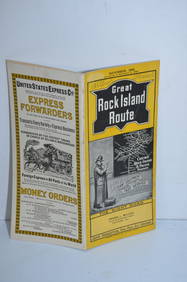
Chicago Rock Island and Pacific RY November 4, 1899 Public TimetableJM Hobby Supply and Railroad Artifact Auctions4.4(126)See Sold PriceFeb 24, 2024
Oregon Short Line RR April 1899 Public TimetableJM Hobby Supply and Railroad Artifact Auctions4.4(126)See Sold PriceFeb 24, 2024
Union Pacific RR July 1899 Public TimetableJM Hobby Supply and Railroad Artifact Auctions4.4(126)See Sold PriceFeb 24, 2024
Museum of Horrors - King of Pigs -Emil Zola - 1899Levy Auction House4.3(11)See Sold PriceFeb 27, 2024
Oil on Board signed Crescencio Camejo and dated 1957 lower leftBasel Auction House4.5(46)See Sold PriceFeb 24, 2024
1683 Sanson Map of the Caribbean -- Les Isles Antilles, &c Entre Lesquelles sont les Lucayes, et lesJasper524.5(9.8k)See Sold PriceFeb 27, 2024
Map of Part of the West Indies, Etc., Showing the Exact Position Of The U.S. War Steamer SanJasper524.5(9.8k)See Sold PriceFeb 27, 2024
COLONIAL AFRICA. British East/Central/South Africa. Bechuanaland 1899 old mapJasper524.5(9.8k)See Sold PriceFeb 28, 2024
COLONIAL EAST AFRICA. German/British/Portuguese East Africa. Tanzania 1899 mapJasper524.5(9.8k)See Sold PriceFeb 28, 2024
OLD MAP of the West Indies/ Carta Esperica/ 1804Churchill Galleries3.7(216)See Sold PriceFeb 26, 2024