SoldTanner's North America independent TexasHeading: (Texas) Author: Tanner, Henry Schenck Title: North America Place Published: Philadelphia Publisher: Date Published: 1836-[1845] Description: Engraved map, hand-coloSee Sold Price
SoldTanner's North America independent TexasHeading: Author: Tanner, Henry Schenck Title: North America Place Published: Philadelphia Publisher: Date Published: 1836-[1845] Description: Engraved map, hand-colored. 38See Sold Price
SoldTANNER, HENRY SCHENCK. North America.TANNER, HENRY SCHENCK. North America. Hand-colored engraved map, 390x330 mm, wide margins; minor soiling in margins. Philadelphia, 1836 With Texas shown as independent from both Mexico and the UnitedSee Sold Price
SoldMap of North America with independent TexasHeading: Author: Johnston, A.K. Title: North America Place Published: London Publisher:John Johnstone, and W. & A.K. Johnston Date Published: 1844 Description: Steel-engraved mSee Sold Price
SoldNorth America with independent TexasHeading: Author: Dufour, Adolphe Hippolyte Title: [Amerique du Nord] Place Published: [Paris] Publisher:Imp. de N. Rémond Date Published: c.1845 Description: Engraved map, hand-See Sold Price
North America with independent Texas 1839Heading: Author: Lorrain, N. Title: Amérique Septentrionale Dressée par N. Lorrain Pere attache au Depot Gal. de la Guerre Place Published: Paris Publisher: Date Published: 1839 DescriSee Sold Price
SoldMap of North America with independent TexasTitle: North America Author: Findley, Alexander Description: Steel-engraved map, hand-colored in outline. 26x21 cm. (10x8½"). Well-engraved map of North America, with Texas shown as an independent coSee Sold Price
SoldNorth America with large independent TexasHeading: Author: Burgess, Daniel Title: Map of North America Designed to Accompany Smith's Geography for Schools Place Published: New York Publisher: Date Published: 1839 Description:See Sold Price
Bradford's North America 1838 Texas a republicTitle: North America Author: Bradford, Thomas Gamaliel Description: Copper-engraved map, hand-colored. Engraved by G.W. Boynton. 36x28 cm. (14x11"), matted.North America, with Texas independent but wiSee Sold Price
Bradford's North America 1838 Texas a republicTitle: North America Author: Bradford, Thomas Gamaliel Description: Copper-engraved map, hand-colored. Engraved by G.W. Boynton. 36x28 cm. (14x11"), matted.North America, with Texas independent but wiSee Sold Price
SoldLapie map of N. America with independent TexasTitle: Carte de l'Amérique Septentrionale Author: Lapie, Pierre & Alexandre Emile Lapie Description: Copper-engraved map, hand-colored in outline. 54.5x39 cm. (21½x15¼").North America, with Texas aSee Sold Price
Manuscript map of North America in DutchIndependent Republic of Texas in Dutch 329. [MAP]. Manuscript map of North America with place names, title, etc. in Dutch:See Sold Price
Arrowsmith map of Americas independent TexasTitle: America Author: Arrowsmith, J[ohn] Description: Copper-engraved map, hand-colored in outline. 59.5x47.5 cm (23½x18¾").Shows both North and South America. Texas represented as a separate natioSee Sold Price
SDUK: Antique Map of North America, 1846NORTH AMERICA, South to Panama.' The map shows national borders as they existed between 1836 and 1845, including the Republic of Texas as an independent state. It shows the US-Mexican border prior toSee Sold Price
SDUK: Antique Map of North America, 1846NORTH AMERICA, South to Panama.' The map shows national borders as they existed between 1836 and 1845, including the Republic of Texas as an independent state. It shows the US-Mexican border prior toSee Sold Price
NORTH AMERICA. Texas Republic. Mexican California.TITLE/CONTENT OF MAP: 'NORTH AMERICA, South to Panama.' The map shows national borders as they existed between 1836 and 1845, including the Republic of Texas as an independent state. It shows the US-MSee Sold Price
SoldNORTH AMERICA.Texas Republic.Mexican California.RussianTITLE/CONTENT OF MAP: 'NORTH AMERICA, South to Panama.' The Republic of Texas is shown as an independent state as it existed between 1836 and 1845; it shows the US-Mexican border prior to the Mexican-See Sold Price
SoldNORTH AMERICA.Texas Republic.Mexican California.RussianTITLE/CONTENT OF MAP: 'NORTH AMERICA, South to Panama.' The Republic of Texas is shown as an independent state as it existed between 1836 and 1845; it shows the US-Mexican border prior to the Mexican-See Sold Price
SoldHenry Schenck Tanner (1786-1858), 1836 MapHenry Schenck Tanner (1786-1858), 1836 map of North America, framed frame: 21.5 x 18" Provenance: A Dallas, TX Estate Henry Schenck Tanner was active/lived in Pennsylvania, New York. Henry TanneSee Sold Price
SoldV. Levasseur, "Amerique Septentrionale," 1846, maV. Levasseur, "Amerique Septentrionale," 1846, map, printed by Raimond Bonheur, Paris, hand colored lithograph, showing Texas as an independent country, central map of north and Central America with dSee Sold Price
NORTH AMERICA.Texas Republic.Mexican California.RussianTITLE/CONTENT OF MAP: 'NORTH AMERICA, South to Panama.' The Republic of Texas is shown as an independent state as it existed between 1836 and 1845; it shows the US-Mexican border prior to the Mexican-See Sold Price
SoldFullarton: Antique Map of Texas & Indian Territory 1860Map: 1860 Fullarton Map of Texas (East/Central), Indian Territory, Louisiana and Arkansas -- United States North America According to Calvin Smith& Tanner . . . South Central Section. Comprising TexasSee Sold Price
GEORGE HERIOT SWANSTON, (Scottish, b. 1814), UnitedGEORGE HERIOT SWANSTON (Scottish, b. 1814) United States, North America, 1862 Hand colored engraving North America according to Calvin Smith and Tanner. The south central section comprising Texas, LouSee Sold Price
SoldSOUTH WESTERN USA.Showing Republic of Texas & MexicanReserve Reduced! TITLE/CONTENT OF MAP: 'CENTRAL AMERICA, SHEET II., INCLUDING TEXAS, CALIFORNIA AND THE NORTHERN STATES OF MEXICO' The map shows the Republic of Texas as an independent state as it exiSee Sold Price
Al Barnes (1937-2015), A Meeting at the PointCopley Fine Art Auctions4.5(40)See Sold PriceFeb 24, 2024
LARGE EARLY 18TH C. DUTCH CHART OF UPPER NORTH AMERICA, PIERRE MORTIER (1661-1711), FRAMEDThomaston Place Auction Galleries4.4(386)See Sold PriceFeb 24, 2024
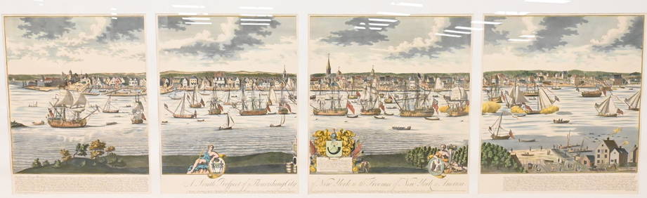
A South Prospect of Ye Flourishing City of New York in the Province of New York, North AmericaNadeau's Auction Gallery4.7(401)See Sold PriceFeb 24, 2024
Audubon's Animals - The Quadrupeds of North America 1954 Folio Size BookNorth American Artifact Auctions4.6(182)See Sold PriceApr 20, 2024
Arrowsmith & Lewis - Map of North AmericaTrillium Antique Prints & Rare Books4.5(30)See Sold PriceFeb 24, 2024
Map: An 18thC engraved and hand coloured map of North America and South America, titled DeClaydon Auctioneers Ltd4.3(125)See Sold PriceFeb 26, 2024
1862 North America Anthony Trollope West Indies AND Spanish Main CANADA NIAGARAJasper524.5(9.8k)See Sold PriceFeb 27, 2024
New and Correct Map of North America With the West India Islands,Jasper524.5(9.8k)See Sold PriceFeb 27, 2024
Map of United States of North America, 1785Antiques Online Auctions4.6(407)See Sold PriceMar 14, 2024