SoldTANNER, HENRY SCHENCK. North America.TANNER, HENRY SCHENCK. North America. Hand-colored engraved map, 390x330 mm, wide margins; minor soiling in margins. Philadelphia, 1836 With Texas shown as independent from both Mexico and the UnitedSee Sold Price
Sold1822 Tanner map, North America,Henry Schenck Tanner, "A Map of North America", four engraved and hand-colored two-page sections, each about 23 x 30-3/4 in., from [A New American Atlas], Philadelphia, 1823, Southwest section with elSee Sold Price
Tanner's large map of North America 1825Title: A Map of North America, Constructed According to the Latest Information Author: Tanner, Henry Schenck Description: Copper-engraved map, hand-colored. Originally issued on 4 sheets, this copy inSee Sold Price
SoldHenry Schenck Tanner (1786-1858), 1836 MapHenry Schenck Tanner (1786-1858), 1836 map of North America, framed frame: 21.5 x 18" Provenance: A Dallas, TX Estate Henry Schenck Tanner was active/lived in Pennsylvania, New York. Henry TanneSee Sold Price
SoldTanner's North America independent TexasHeading: (Texas) Author: Tanner, Henry Schenck Title: North America Place Published: Philadelphia Publisher: Date Published: 1836-[1845] Description: Engraved map, hand-coloSee Sold Price
SoldTanner's North America independent TexasHeading: Author: Tanner, Henry Schenck Title: North America Place Published: Philadelphia Publisher: Date Published: 1836-[1845] Description: Engraved map, hand-colored. 38See Sold Price
Sold* TANNER, Henry Schenck. United States of America: by* TANNER, Henry Schenck. United States of America: by H. S. Tanner, 1829... Entered... the 30th day of July, 1830. Philadelphia, 30 July 1830. Engraved folding map, overall 1244 x 1634 mm, full hand-cSee Sold Price
Sold(MAP) TANNER, HENRY SCHENCK. United States of America. (MAP) TANNER, HENRY SCHENCK United States of America. Philadelphia: Henry S. Tanner, 10 June, 1829. Folding engraved map hand-colored in outline, in 60 sections backed onto linen, edged in blue silk rSee Sold Price
SoldTANNER, HENRY SCHENCK. United States of AmericTANNER, HENRY SCHENCK. United States of America. Large engraved case map in 60 sections. 1165x1545 mm overall; hand-colored in outline; linen-backed, with publisher's 1/2 roan case, neatly rebacked anSee Sold Price
SoldTanner (H S) West Indies; South America;Tanner (Henry Schenck) West Indies; South America; Mexico & Guatemala,3 engraved maps with original hand-colouring, approximately 285 x 360mm., a few small isolated stains, sheet edges brownedSee Sold Price
SoldHenry Schenk Tanner (1786-1858), "North America - PartsHenry Schenk Tanner (1786-1858), "North America - Parts of Louisiana, Arkansas, Mississippi, Alabama, and Florida," 1833, published by Baldwin and Gradock, London, framed, H.- 13 1/2 in., W.- 16 1/2 iSee Sold Price
SoldTwo 1836 Hand Colored Maps of Italy, Burr & TannerA pair of 19th century maps of Italy comprising of "Italy, North Part" by Henry Schenck Tanner_x000D_ (American, 1786-1858) engraved by E.B. Dawson, published in 1836 as part of "Tanner's Universal AtSee Sold Price
SoldTANNER, HENRY SCHENCK. Atlas of the United StaTANNER, HENRY SCHENCK. Atlas of the United States: Containing Maps of each of the States, in the North American Union. 25 hand-colored engraved mapsheets, with 14 maps dated 1836. Folio, 400x315 mm, pSee Sold Price
Sold* TANNER, Henry Schenck. A New American Atlas* TANNER, Henry Schenck (1786-1858). A New American Atlas containing Maps of the Several States of the North American Union. Philadelphia: By the Author, [1818-]1823. Folio (582 x 404 mm). 18 engravedSee Sold Price
SoldTanner American Atlas in Original BoxTanner, Henry Schenck (1786-1858). A New American Atlas containing Maps of the Several States of the North American Union. Philadelphia: By the Author, 1823. A landmark in American cartography... theSee Sold Price
SoldRARE BOUND ATLAS, HENRY SCHENCK TANNER, TITLEDTHE NEW AMERICAN ATLAS, CONTAINING MAPS OF THE SEVERAL STATES OF THE NORTH AMERICAN UNION, PROJECTED AND DRAWN UPON A UNIFORM SCALE, FROM THE DOCUMENTS FOUND IN THE PUBLIC OFFICES OF THE UNITED STATESSee Sold Price
SoldHANDCOLORED "MAP OF NORTH & SOUTH CAROLINA BY H.S.HANDCOLORED "MAP OF NORTH & SOUTH CAROLINA BY H.S. TANNER". Engraved and published in Philadelphia, August 20, 1823, by Henry Schenck Tanner with the heading for the "American Atlas". Good color and sSee Sold Price
North America Sheet Ix Parts of Missouri, Illinois, andTitle: North America Sheet Ix Parts of Missouri, Illinois, and Indiana Prublication Date: 1833-07-01 Cartographer: Walker, J. & C. | Henry Schenk Tanner Publisher: Edward Stanford/S.D.U.K. Size: 12HeiSee Sold Price
SoldBarralet Engraving of AmericaBARRALET, John J. (1747-1815). America Guided by Wisdom. Engraving. Philadelphia: B Tanner, c. 1815. 18" x 23" sheet. Comparable: Swann Galleries, 2016 - $2,750. An allegorical representation of the USee Sold Price
SoldTANNER, Henry Schenck (1786-1858).* TANNER, Henry Schenck (1786-1858). A New Universal Atlas Containing Maps of the various Empires, Kingdoms, States and Republics of the World. Philadelphia: S. Augustus Mitchell, 1846. Folio (442 x 3See Sold Price
Sold* TANNER, Henry Schenck (1786-1858). A New College* TANNER, Henry Schenck (1786-1858). A New College Atlas consisting of a series of General Maps of the Various Grand Divisions of the Known World. Adapted to the Course of Geographical Instruction usuSee Sold Price
Sold(TEXAS.) Tanner, Henry Schenck. A Map of the U(TEXAS.) Tanner, Henry Schenck. A Map of the United States of Mexico . . . Second Edition. Hand-colored engraved folding pocket map, 590x745 mm; few minor spots, some minor browning along folds, verySee Sold Price
SoldTANNER, HENRY SCHENCK. A Map of the United StaTANNER, HENRY SCHENCK. A Map of the United States including every county Enumerated in the Census of 1840. Hand-colored engraved case map in 32 sections, 1205x1605 mm overall; linen-backed; housed inSee Sold Price
SoldTANNER, HENRY SCHENCK. A New Universal Atlas cTANNER, HENRY SCHENCK. A New Universal Atlas containing Maps of the various Empires, Kingdoms, States and Republics of the World. Engraved title, 68 hand-colored mapsheets, plus the rivers and mountaiSee Sold Price
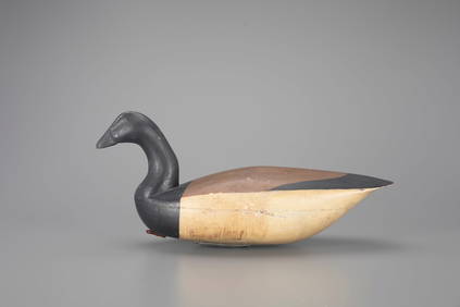
Rare Brant Decoy by Henry Kilpatrick (1867-1945)Copley Fine Art Auctions4.5(40)See Sold PriceFeb 24, 2024
LARGE EARLY 18TH C. DUTCH CHART OF UPPER NORTH AMERICA, PIERRE MORTIER (1661-1711), FRAMEDThomaston Place Auction Galleries4.4(386)See Sold PriceFeb 24, 2024
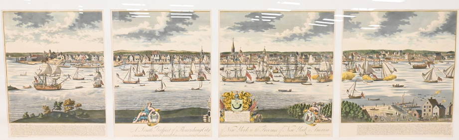
A South Prospect of Ye Flourishing City of New York in the Province of New York, North AmericaNadeau's Auction Gallery4.7(401)See Sold PriceFeb 24, 2024
Brave Men by Ernie Pyle 1944 WWII Correspondent StoriesNorth American Artifact Auctions4.6(182)See Sold PriceApr 20, 2024
Audubon's Animals - The Quadrupeds of North America 1954 Folio Size BookNorth American Artifact Auctions4.6(182)See Sold PriceApr 20, 2024
Arrowsmith & Lewis - Map of North AmericaTrillium Antique Prints & Rare Books4.5(30)See Sold PriceFeb 24, 2024
Map: An 18thC engraved and hand coloured map of North America and South America, titled DeClaydon Auctioneers Ltd4.3(125)See Sold PriceFeb 26, 2024
1862 North America Anthony Trollope West Indies AND Spanish Main CANADA NIAGARAJasper524.5(9.8k)See Sold PriceFeb 27, 2024
New and Correct Map of North America With the West India Islands,Jasper524.5(9.8k)See Sold PriceFeb 27, 2024
Map of United States of North America, 1785Antiques Online Auctions4.6(407)See Sold PriceMar 14, 2024