ATLAS of ANTIENT GEOGRAPHY by SAMUEL BUTLER 1843John McInnis Auctioneers,LLC4.5(505)See Sold PriceFeb 24, 2024
18TH C. ANTIQUE MAP: FRENCH & INDIAN WAR, FRAMEDThomaston Place Auction Galleries4.4(393)See Sold PriceFeb 24, 2024
Rand McNally Railroad Map Cabinet w/ 21 Railroad MapsRail & Road Auctions4.6(165)See Sold PriceMar 08, 2024
Keith Haring - Ink on New York Map, Best Buddies, Inscribed, Signed, and DatedSapphire Auction Gallery4(67)See Sold PriceMar 02, 2024
LATE 17TH C. FRENCH MAP OF THE NEW WORLD BY ALEXIS-HUBERT JAILLOT (1632-1712)Thomaston Place Auction Galleries4.4(393)See Sold PriceFeb 24, 2024
Central Railroad of New Jersey Map of Sandy Hook Route-ca. 1903JM Hobby Supply and Railroad Artifact Auctions4.4(127)See Sold PriceFeb 24, 2024
Lot of Six Mixed Atlas Box Cars-HO Scale-New in BoxJM Hobby Supply and Railroad Artifact Auctions4.4(127)See Sold PriceFeb 25, 2024
Rand McNally/Santa Fe Railroad Map of Iowa-1912JM Hobby Supply and Railroad Artifact Auctions4.4(127)See Sold PriceFeb 24, 2024
NICOLAES VISSCHER (NETHERLANDS, 1618-1709) MAP OF THE NEW WORLDThomaston Place Auction Galleries4.4(393)See Sold PriceFeb 24, 2024
17TH C. WORLD MAP BY NICOLAES VISSCHER (NETHERLANDS, 1618-1709)Thomaston Place Auction Galleries4.4(393)See Sold PriceFeb 24, 2024
Lot of Six Mixed Atlas Cabooses-HO Scale-New in BoxJM Hobby Supply and Railroad Artifact Auctions4.4(127)See Sold PriceFeb 25, 2024
SoldTallis map of Texas, California & Mexico 1849Heading: (Texas) Author: Tallis, John Title: Mexico, California and Texas Place Published: London, Edinburgh & Dublin Publisher: Date Published: [1849] Description: Steel-enSee Sold Price
SoldTallis. Mexico: California and Texas. 1849[Mexico] Tallis, John. Rapkin, John. “Mexico: California and Texas.” J. & F. Tallis, London, 1849. Engraved map. 13” x 9 3/4”. Framed: 16 1/4” x 14 1/4”. First issuSee Sold Price
SoldTallis map of Texas, California & Mexico 1851Heading: (Texas) Author: Tallis, John Title: Mexico, California and Texas Place Published: London & New York Publisher: Date Published: [1851] Description: Steel-engraved map, drSee Sold Price
Tallis map of Texas, California & Mexico 1851Heading: (Texas) Author: Tallis, John Title: Mexico, California and Texas Place Published: London & New York Publisher: Date Published: [1851] Description: Steel-engraved maSee Sold Price
SoldTallis map of Texas, California & Mexico c.1850Title: Mexico, California and Texas Author: Tallis, John Description: Steel-engraved map, drawn and engraved by J. Rapkin, hand-colored in outline, with decorative border and vignettes uncolored. TheSee Sold Price
SoldTallis map of Texas, California & Mexico c.1850Title: Mexico, California and Texas Author: Tallis, John Description: Steel-engraved map, drawn and engraved by J. Rapkin, hand-colored in outline, with decorative border and vignettes uncolored. TheSee Sold Price
SoldRAPKIN TALLIS ILLUS. MAP MEXICO CALIFORNIA & TEXASFramed hand-colored illustrated map, Mexico, California, and Texas, mid 19th c., map drawn and engraved by John Rapkin (1815-1876), illustrations after Henry Warren (1794-1879), engraved by John RogerSee Sold Price
SoldTallis, John (Pub) 1852 Map. Mexico, California & TexasSteel Engraved Map with Original Outline Hand Color Published 1852-56 by John Tallis, London for "The Universal Pronouncing Dictionary" by Thomas Wright. Drawn & Engraved by John Rapkin. Centre fold aSee Sold Price
Sold1850 Tallis map of Mexico California During Gold RushReserve Reduced! Title/Content of Map: 1850 Tallis map of Mexico California During Gold Rush and Texas -- Mexico, California and Texas Date: 1850, London Cartographer: J Tallis Size: 10 X 13 in. ThisSee Sold Price
SoldTallis 1850 Map of Texas & Calif.Steel engraving with hand coloring, full title being "Mexico, California and Texas", engraved by J. Rapkin, with decorative border and vignettes of gold miners, Indians, peasants andRuins at Uxmal, YuSee Sold Price
SoldMEXICO, CALIFORNIA & TEXAS, MAP W/ GOLD RUSH VIGNETTESA rare circa 1850 map by John Tallis, nice decorative borders and highlights and legend of "The newly discovered gold strikes". Added to this is an atlas map of the WESTERN TERRITORIES OF THE UNITED SSee Sold Price
MEXICO CALIFORNIA TEXAS. Gold rush district. TX Republic.TALLIS/RAPKIN 1851 mapTitle: MEXICO CALIFORNIA TEXAS. Gold rush district. TX Republic.TALLIS/RAPKIN 1851 map Description: Mexico, California & Texas' by Map drawn and engraved by J. Rapkin; vignette illustrations drawn bySee Sold Price
MEXICO CALIFORNIA TEXAS. Gold rush district. TX Republic.TALLIS/RAPKIN 1851 mapTitle: MEXICO CALIFORNIA TEXAS. Gold rush district. TX Republic.TALLIS/RAPKIN 1851 map Description: Mexico, California & Texas' by Map drawn and engraved by J. Rapkin; vignette illustrations drawn bySee Sold Price
SoldMAP, US & Mexico, TallisSouthern United States & Mexico. John Tallis, Mexico, California and Texas, from Illustrated Atlas and Modern History of the World, 1850 (circa). Hand Color. This is the second, and most desirable, stSee Sold Price
SoldTallis, John. Mexico, California and Texas. London, ca.Tallis, John. Mexico, California and Texas. London, ca. 1848. Engraved map with coloured limits, 25x33 cm. 1st edition very rare.See Sold Price
SoldTallis, John. Mexico, California and Texas. London, ca.Tallis, John. Mexico, California and Texas. London, ca. 1850. Engraved map with coloured limits, 26.5 x 36 cm. Framed.See Sold Price
[MAP]. RAPKIN et al. Mexico, California and TexasThe Preferred State with the California Gold Washers 354. [MAP]. RAPKIN, J[ohn Drew] (draftsman & engraver), John TalliSee Sold Price
SoldNorth America with large Texas 1849Title: Oregon, Upper California, Texas, Mexico, Guatimala, West Indies Author: Olney, Jesse Description: Woodcut map, hand-colored. 20x26 cm. (8x10").Interesting map from Olney's Family Geography, witSee Sold Price
SoldJohn Tallis / PublisherJohn Tallis / Publisher, "Mexico, California and Texas", 1851, London, hand-colored engraved map by J. Rapkin, vignettes of gold miners, ruins of Yucatan and peasants by H. Warner, the exaggerated golSee Sold Price
SoldMexico & Southwest with independent TexasHeading: Author: Black, Adam & Charles Title: Mexico, California & Texas Place Published: Edinburgh Publisher:A. & C. Black Date Published: c.1849 Description: Engraved map, engSee Sold Price
SoldMexico, California and TexasJ. Rapkin. Lithographed map with original hand color in outline. New York: J. & f. Tallis, 1851. 10 x 13 1/4 inches, 20 1/2 x 22 1/4 inches framed. Privately printed, very rare map of Washington, MontSee Sold Price
Sold(2pc) MAPS OF NORTH AMERICAincluding MEXICO, CALIFORNIA, AND TEXAS, By J. Rapkin, with illustrations by W. Warren and Engraved by J. Rogers, lithograph with handcoloring, J. & F. Tallis, London, Edinburgh, and Dublin, 1851, 10-See Sold Price
SoldTallis (John) North AmericaTallis (John) North America; United States; British America; Mexico, California and Texas, and Nova Scotia and Newfoundland,with decorative borders and vignette views, 5 engraved maps by RapkiSee Sold Price
Sold1854 Black's Map of Mexico, Texas and California --Title/Content of Map: 1854 Black's Map of Mexico, Texas and California -- Mexico, California, Texas Date: 1854, Edinburgh Cartographer: A & C Black Size: 10 X 14.5 in. This is a very nice map of MexicSee Sold Price
Hardie Gramatky (TX,CT,CA,1907-1979) gouache paintingBroward Auction Gallery4.7(292)See Sold PriceMar 10, 2024
Hardie Gramatky (TX,CT,CA,1907-1979) gouache paintingBroward Auction Gallery4.7(292)See Sold PriceMar 10, 2024
VARIOUS ARTISTS [SANTA FE RAILROAD]. Group of 4 posters. Circa 1950s.Swann Auction Galleries4.4(70)See Sold PriceFeb 29, 2024
Ward Lockwood (American, 1894-1963) Fantasy in Yellow, 1960Freeman's | Hindman4.4(1.6k)See Sold PriceMar 07, 2024
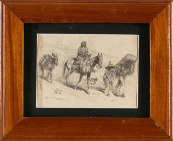
JOHN EDWARD BOREIN (California, 1872-1945), "Mexico", depicting a woman on horseback and two menEldred's4.7(419)See Sold PriceMar 07, 2024


![[MAP]. RAPKIN et al. Mexico, California and Texas (1 of 5)](https://p1.liveauctioneers.com/514/20078/6859804_1_x.jpg?height=282&quality=70)


![VARIOUS ARTISTS [SANTA FE RAILROAD]. Group of 4 posters. Circa 1950s. (1 of 1)](https://p1.liveauctioneers.com/199/319703/171640606_1_x.jpg?height=282&quality=70&version=1707943705)