ATLAS of ANTIENT GEOGRAPHY by SAMUEL BUTLER 1843John McInnis Auctioneers,LLC4.6(504)See Sold PriceFeb 24, 2024
18TH C. ANTIQUE MAP: FRENCH & INDIAN WAR, FRAMEDThomaston Place Auction Galleries4.4(389)See Sold PriceFeb 24, 2024
Rand McNally Railroad Map Cabinet w/ 21 Railroad MapsRail & Road Auctions4.6(165)See Sold PriceMar 08, 2024
Keith Haring - Ink on New York Map, Best Buddies, Inscribed, Signed, and DatedSapphire Auction Gallery4.1(67)See Sold PriceMar 02, 2024
LATE 17TH C. FRENCH MAP OF THE NEW WORLD BY ALEXIS-HUBERT JAILLOT (1632-1712)Thomaston Place Auction Galleries4.4(389)See Sold PriceFeb 24, 2024
Central Railroad of New Jersey Map of Sandy Hook Route-ca. 1903JM Hobby Supply and Railroad Artifact Auctions4.4(126)See Sold PriceFeb 24, 2024
Lot of Six Mixed Atlas Box Cars-HO Scale-New in BoxJM Hobby Supply and Railroad Artifact Auctions4.4(126)See Sold PriceFeb 25, 2024
Rand McNally/Santa Fe Railroad Map of Iowa-1912JM Hobby Supply and Railroad Artifact Auctions4.4(126)See Sold PriceFeb 24, 2024
NICOLAES VISSCHER (NETHERLANDS, 1618-1709) MAP OF THE NEW WORLDThomaston Place Auction Galleries4.4(389)See Sold PriceFeb 24, 2024
17TH C. WORLD MAP BY NICOLAES VISSCHER (NETHERLANDS, 1618-1709)Thomaston Place Auction Galleries4.4(389)See Sold PriceFeb 24, 2024
Lot of Six Mixed Atlas Cabooses-HO Scale-New in BoxJM Hobby Supply and Railroad Artifact Auctions4.4(126)See Sold PriceFeb 25, 2024
SoldPocket map of Ohio. 1853MAP - THAYER, Bridgeman & Fanning (publishers). Railroad & Township Map of Ohio.New York: Thayer, 1853. Engraved folding pocket map hand-colored in outline (800x700 mm). Folds into publisherSee Sold Price
SoldSCARBOROUGH'S NEW RR, POST OFFICE, TOWNSHIP & CTY. MAPSCARBOROUGH'S NEW RAILROAD, POST OFFICE, TOWNSHIP & COUNTY MAP OF NEW YORK, 19TH C., 43" X 48"See Sold Price
SoldColton's Map of the State of New York 1857Heading: Author: Colton, J. H. Title: Colton's Railroad & Township Map of the State of New York with Parts of Adjoining States & Canada Place Published: New York Publisher:J.H. Colton Date PubliSee Sold Price
Sold1 piece. Colton, J.H., pub. Colton's Railroad & T1 piece. Colton, J.H., pub. Colton's Railroad & Township Map of the State of New York." New York, 1865. Hand-colored lithographic map, 26 x 28 inches. Tears along folds but complete. In orig. red clotSee Sold Price
SoldEarly Roll-Up New York MapEarly roll-up New York map, "SCARBOROUGH'S / NEW / RAILROAD, POST OFFICE, TOWNSHIP / AND COUNTY MAP OF / NEW YORK". Imperfections. 48" x 41"See Sold Price
SoldVINTAGE TRAVEL EPHEMERA, UNCOUNTED LOTVINTAGE TRAVEL EPHEMERA, UNCOUNTED LOT, including cruise line menus, passenger lists, brochures, and postal covers, National Publishing Co. Railroad, Post Office, Township and County Map of New York,See Sold Price
Soldscarborough's map of new york 19031903 Scarborough's new railroad, post office, township and county map of New York with distances between stations. Tears; stained; needs repair. 49 1/2 inches wide x 40 inches high.See Sold Price
SoldAntique New York State Map 1903 Color Roll Up RR Map1903 Scarborough's New Railroad, Post Office, Township and County Map of New York. Color map, compiled from the latest government and state surveys and original sources of the era. Insets: Map of NewSee Sold Price
SoldEMPIRE GROUP 1898 ROLL DOWN MAP A NEW RAILROAD, POSTEMPIRE GROUP 1898 ROLL DOWN MAP A NEW RAILROAD, POST OFFICE TOWNSHIP AND COUNTY MAP OF NEW YORK, NEW JERSEY, AND PENNSYLVANIA. NATIONAL PUBLISHING COMPANY, BOSTON 1898. BOTTOM 26" IN BETTER CONDITION,See Sold Price
SoldGeorge Colton RAILROAD & TOWNSHIP MAP OF MASSACHUSETTSDetails: COLTON, George W. (1827-1901) & Charles B. (1832-1916). Colton's Railroad & Township Map of Massachusetts, Rhode Island, Connecticut with parts of Maine, New Hampshire, Vermont & New York. NSee Sold Price
SoldG. Woolworth Colton's Railroad Map. New England.[New England] Colton, George Woolworth (American, 1827-1901). "G. Woolworth Colton's Railroad, Township and Distance Map of New England with Adjacent Portions of New York, Canada and New Brunswick." GSee Sold Price
Sold* Two Maps Depicting Missouri* Two Maps Depicting Missouri G.W. & C.B. COLTON & CO. (MAP) Colton's Missouri. New York. Lithograph with hand-coloring. Framed. BRINK McDONOUGH & CO. Township & Railroad Map of MisSee Sold Price
Sold1868 Broadside Railroad Map, NY + New OrleansHistoric Maps1868 Broadside Railroad Map "New York & New Orleans" 1868, Color Broadside Railroad Map Advertisement, "New York & New Orleans," Choice Extremely Fine. This excellent, oriSee Sold Price
Sold1875 Railroad Map Of New York1875 Railroad map of New York. Revised map of the railroads of State of N.Y.. Prepared under the direction of S.H. Sweet & D.M. Greene 1875. Hand colored. Folds as issued. 28 1/2" x 34 3/4".See Sold Price
Distrunell Township Map of New York, 18551855 Distrunell Township Map of New York -- Map of the State of New York Showing the Boundaries of Counties & Townships, the Location of Cities, Towns and Villages: and the Courses of Rail Roads, CanaSee Sold Price
SoldDistrunell: Antique Township Map of New York, 1855Map: 1855 Distrunell Township Map of New York -- Map of the State of New York Showing the Boundaries of Counties & Townships, the Location of Cities, Towns and Villages: and the Courses of Rail Roads,See Sold Price
Sold2 Colton Pocket Maps, State of New York 1856 and2 Colton Pocket Maps, State of New York 1856 and Township Map of New York 1872-- Dimensions: ---See Sold Price
SoldTwo large folio bindings containing original hand drawnTwo large folio bindings containing original hand drawn and water colored railroad maps: 1) "New York Kingston & Syracuse Railroad / Right of Way Map From Deans to Oneonta" - PAGE SIZE 30" X 21" - 22See Sold Price
Sold1854 TOWNSHIP & RAILROAD MAP of NEW HAMPSHIREPublished by J.R. Dodge Nashua, NH. 36 x 26 inches.See Sold Price
SoldNew England New York Railroad MapRailroad, Steam Boat & Stage Route of New England, New York, Canada, Antique Map by Shearman & Smith, 1852. 22 3/4" x 28".See Sold Price
Soldc.1880 New Railroad and County Map of New YorkImage Type: Hand Colored Engraving Scale: 36 miles to 1 inch>br>Dimensions: 13 3/4"(l) x 11 1/2"(w) For your consideration is a hand-colored engraved railroad and county map of New York. This highly dSee Sold Price
Soldca. 1929 RAILROAD UNITED STATES MAP SHOWING NEW YORKVintage Railroad Map, "MAP of THE UNITED STATES SHOWING NEW YORK CENTRAL LINES". Map by Rand McNally and Co. Includes printed information on the reverse. Tiny text along bottom partly reads; "NY 4-29"See Sold Price
Sold3 Pcs Railroad Ephemera incl MapsIncludes 1867 Map of the Railroad of the State of New York, General Railroad Map of the United States and Canada and a Railroad Man's Prayer. IMPORTANT: Before bidding, please read the terms and condiSee Sold Price
Michigan Southern and Northern Indiana RR 14th Annual Report-February 28, 1869JM Hobby Supply and Railroad Artifact Auctions4.4(126)See Sold PriceFeb 24, 2024
1892 Adams and Bowles New Road Map of the State of New YorkJM Hobby Supply and Railroad Artifact Auctions4.4(126)See Sold PriceFeb 24, 2024
American Express/New York Central Railroad Map of the United States-1934JM Hobby Supply and Railroad Artifact Auctions4.4(126)See Sold PriceFeb 24, 2024
Crams Railroad Map of New York-1881JM Hobby Supply and Railroad Artifact Auctions4.4(126)See Sold PriceFeb 24, 2024
Crams Township and Railroad Map of New York-1890JM Hobby Supply and Railroad Artifact Auctions4.4(126)See Sold PriceFeb 24, 2024
Erie Railway Tourist Book/Magazine-1874JM Hobby Supply and Railroad Artifact Auctions4.4(126)See Sold PriceFeb 24, 2024
New York Central RR The Adirondacks Brochure 1916-1917JM Hobby Supply and Railroad Artifact Auctions4.4(126)See Sold PriceFeb 24, 2024
No Smoking/Spitting Porcelain New York Railroad SignJM Hobby Supply and Railroad Artifact Auctions4.4(126)See Sold PriceFeb 24, 2024
New York Central and Hudson River RR Public Timetable-November 3, 1901JM Hobby Supply and Railroad Artifact Auctions4.4(126)See Sold PriceFeb 24, 2024
Vintage County Map Of NY State Plate EngravingThe Benefit Shop Foundation Inc.4.3(2.9k)See Sold PriceFeb 28, 2024
Group of New York Central Railroad Paper - Rule Books, Employee Timetables, Stationary, Log Books,Rail & Road Auctions4.6(165)See Sold PriceMar 07, 2024
Early Pennsylvania Railroad Literature - 1881 New York and Chicago Limited Timetable Brochure andRail & Road Auctions4.6(165)See Sold PriceMar 07, 2024
1853 Colton's Railroad & Township Map of Massachusetts, Rhode Island, and ConnecticutRail & Road Auctions4.6(165)See Sold PriceMar 07, 2024
1855 Map of New York & Erie Railroad and 1917 Trespassing On Railway Property Is A MisdemeanorRail & Road Auctions4.6(165)See Sold PriceMar 07, 2024
Nine Railroad Lock Oiler Keys - Lake Shore & Michigan Southern Railroad and New York CentralRail & Road Auctions4.6(165)See Sold PriceMar 07, 2024
Group of Ten Railroad Photographs, Maps, and Prints - New Jersey, Long Island, and New YorkRail & Road Auctions4.6(165)See Sold PriceMar 07, 2024
Pair of Dietz Vesta Railroad Lanterns - New York Central and Union? RailroadRail & Road Auctions4.6(165)See Sold PriceMar 07, 2024
Keith Haring - Ink on New York Map, Best Buddies, Inscribed, Signed, and DatedSapphire Auction Gallery4.1(67)See Sold PriceMar 02, 2024
1867 Map of the Railroads of The State of New YorkRail & Road Auctions4.6(165)See Sold PriceMar 08, 2024
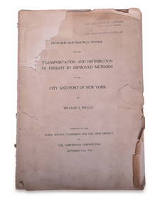
1908 Report on Proposed New York / New Jersey New Railway SystemRail & Road Auctions4.6(165)See Sold PriceMar 08, 2024
Twelve Cleveland, Cincinnati, Chicago & St. Louis Railroad / New York Central Employee TimetablesRail & Road Auctions4.6(165)See Sold PriceMar 08, 2024