ATLAS of ANTIENT GEOGRAPHY by SAMUEL BUTLER 1843John McInnis Auctioneers,LLC4.6(504)See Sold PriceFeb 24, 2024
18TH C. ANTIQUE MAP: FRENCH & INDIAN WAR, FRAMEDThomaston Place Auction Galleries4.4(389)See Sold PriceFeb 24, 2024
Rand McNally Railroad Map Cabinet w/ 21 Railroad MapsRail & Road Auctions4.6(165)See Sold PriceMar 08, 2024
Keith Haring - Ink on New York Map, Best Buddies, Inscribed, Signed, and DatedSapphire Auction Gallery4.1(67)See Sold PriceMar 02, 2024
LATE 17TH C. FRENCH MAP OF THE NEW WORLD BY ALEXIS-HUBERT JAILLOT (1632-1712)Thomaston Place Auction Galleries4.4(389)See Sold PriceFeb 24, 2024
Central Railroad of New Jersey Map of Sandy Hook Route-ca. 1903JM Hobby Supply and Railroad Artifact Auctions4.4(126)See Sold PriceFeb 24, 2024
Lot of Six Mixed Atlas Box Cars-HO Scale-New in BoxJM Hobby Supply and Railroad Artifact Auctions4.4(126)See Sold PriceFeb 25, 2024
Rand McNally/Santa Fe Railroad Map of Iowa-1912JM Hobby Supply and Railroad Artifact Auctions4.4(126)See Sold PriceFeb 24, 2024
NICOLAES VISSCHER (NETHERLANDS, 1618-1709) MAP OF THE NEW WORLDThomaston Place Auction Galleries4.4(389)See Sold PriceFeb 24, 2024
17TH C. WORLD MAP BY NICOLAES VISSCHER (NETHERLANDS, 1618-1709)Thomaston Place Auction Galleries4.4(389)See Sold PriceFeb 24, 2024
Lot of Six Mixed Atlas Cabooses-HO Scale-New in BoxJM Hobby Supply and Railroad Artifact Auctions4.4(126)See Sold PriceFeb 25, 2024
SoldFRAMED 1885 COLBY AND STUART MAP OF PORTLAND, MAINE1885 George N. Colby and J. H. Stuart map of Portland, Maine. Prepared for and published in Colby's Atlas of Maine in 1885. The map depicts from Liconia to East Deering and from Woodfords to South PorSee Sold Price
SoldMAP OF HANCOCK COUNTY, MAINE.This framed example removed from "The Atlas of the State of Maine", published by George N. Colby, Houlton, ME., 1885. The map shows Hancock County from Lowell and Burlington south to the Isle au Haut.See Sold Price
SoldPORTLAND MAINE MAPSLOT 2 PORTLAND MAINE MAPS - 1 FRAMED 9'' X 23'' & 1 SHRINKWRAPPED 17'' X 26 1/4''See Sold Price
SoldBirdseye view of the city of Portland, Maine,framed map, dated 1876. Published by J. Stoner, Madison, WI. After Joseph Warner, artist. Charles Shober & Co., Chicago, lithographers. Shows harbor with boats, docks, streets. Sight size 25" x 35", oSee Sold Price
Antique Map of Portland, Maine.Handcolored lithograph, 16 x 24 inches, sight. Framed, 24 x 30 inches.See Sold Price
Sold[4] Framed maps, French 18th Century; Colton’s map of[4] Framed maps, French 18th Century; Colton’s map of Maine; Maine, New Hampshire and Vermont; Portland – Cumberland.See Sold Price
SoldState of Maine Colby Atlas 1885 Binding as is, mapsState of Maine Colby Atlas 1885 Binding as is, maps are intactSee Sold Price
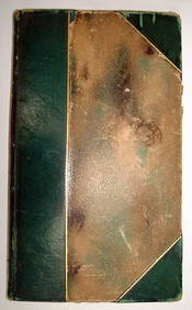
SoldState Atlas of Maine 1887-1888 Fourth EditionPublished by Colby and Stuart. Hardcover half leather bound with blind and gilt stamped cloth boards. 17 x 14 1/2 inches. 111pp. Condition: Large key map taped, endpaper and title page taped into bindSee Sold Price
SoldFRAMED MAINE SCHOOL MAP1862 Map of the State of Maine by H.F. Walling, published by J. Chace, Jr. in Portland, having cartouches of town plans with landowners' names and mountains; plus 1861 Map of the United States by theSee Sold Price
Sold(10) FRAMED COASTAL MAINE BROADSIDES - All circa(10) FRAMED COASTAL MAINE BROADSIDES - All circa 1870-1885, printed on pale colored thin paper, including: "Eastern and Portland, Saco & Portsmouth Railroads 1871 Summer Schedule, 26" x 19 1/2"; PLUSSee Sold Price
State of Maine Atlas and Cumberland County Map1884 fourth edition by Colby of Houlton Maine. 1854 Cumberland County map - estate as found condition. Map of Cumberland County on canvas by Sydney Baker Company of Portland and Philadelphia, J ChaceSee Sold Price
Sold1910 Eldridge Chart of New EnglandOriginal 1910 chart of the New England coast from Gloucester to the Kennebec River in Maine. Many ports along the way are noted including Wells, Bath, Portland, Camden, etc. Nicely framed. Dimensions:See Sold Price
SoldTwo framed maps of Maine depicting: Chart of BoothTwo framed maps of Maine depicting: Chart of Boothbay, Historical Map of Arcadia in English and French 53 x 29 1/2 with Damariscotta, Sheepscot and Kennebec Rivers and soundings in feet other framed HSee Sold Price
Sold1898 Cram Map of Portland, Maine -- City of PortlandTitle: 1898 Cram Map of Portland, Maine -- City of Portland Maine Date: 1898, Chicago Cartographer: G Cram Size: 9.7 X 12.1in. Additional Information: This is a nice, and highly detailed map of PortlaSee Sold Price
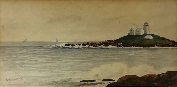
Framed Photo Portland Maine Griggin ClubVintage Print, Aerial View, Portland Maine Harbor With Ships, 36x24See Sold Price
1898 Cram Map of Portland, Maine -- City of PortlandReserve Reduced! Title/Content of Map: 1898 Cram Map of Portland, Maine -- City of Portland Maine Date: 1898, Chicago Cartographer: G Cram Size: 9.7 X 12.1 in. This is a nice, and highly detailed mapSee Sold Price
1898 Cram Map of Portland, Maine -- City of PortlandTitle: 1898 Cram Map of Portland, Maine -- City of Portland Maine Date: 1898, Chicago Cartographer: G Cram Size: 9.7 X 12.1 in. Additional Information: This is a nice, and highly detailed map of PortlSee Sold Price
Sold(2) FRAMED MAPS - PROUTS NECK, MAINE & COUNTY MAYO,Lot of (2) Maps, incl: Map of Prouts Neck, Maine, 1976 by Yvonne L. O. Dickson, hand colored, with houses and historical highlights, in a gilded wooden frame, 24" x 28", glass cracked; and 19th c. MapSee Sold Price
SoldFRAMED 1856 MAP OF MAINEMaine Map, published by J.H. Colton & Co., No. 172 William St., New York, entered according to Act of Congress in the Year 1855, No. 9, published in Colton's Atlas of the World, by George W. Colton, iSee Sold Price
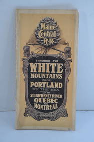
Maine Central RR Through the White Mtns-Portland to the St Lawrence River Book-1901JM Hobby Supply and Railroad Artifact Auctions4.4(126)See Sold PriceFeb 24, 2024
ROBERT BROWNING Rare 1902 LE "Pippa Passes" Calf Binding 1st EdLuis Porretta Fine Arts4.3(10)See Sold PriceMar 02, 2024
1937 Holland, Michigan, Tulip Time Map Guide, FramedLakeshore Event Center4.6(105)See Sold PriceMar 02, 2024
Wenceslaus Hollar. Portraits. To include: James Stainer, Prince Rupert of Bavaria, Lady MaryTremont Auctions4.6(294)See Sold PriceFeb 25, 2024
Kilburg Geochron Lighted Scrolling Framed MapNadeau's Auction Gallery4.7(405)See Sold PriceFeb 24, 2024
1855 Map of New York & Erie Railroad and 1917 Trespassing On Railway Property Is A MisdemeanorRail & Road Auctions4.6(165)See Sold PriceMar 07, 2024
Pair of Early Railroad Maps - 1874 Delaware, Lackawanna & Western and 1876 Pennsylvania RailroadRail & Road Auctions4.6(165)See Sold PriceMar 07, 2024
Pair of Early Railroad Maps - 1862 Pittsburgh, Ft. Wayne & Chicago Railway and 1873 PennsylvaniaRail & Road Auctions4.6(165)See Sold PriceMar 07, 2024
1867 Map of the Railroads of The State of New YorkRail & Road Auctions4.6(165)See Sold PriceMar 08, 2024
[NEW YORK STATE]. Scrapbook of photographs of Lake George a...Potter & Potter Auctions4.6(544)See Sold PriceMar 07, 2024
Two (2) Antique 18th C. Copper Engraved Framed Maps - America & EuropeMagnusson Art Group4.5(50)See Sold PriceMar 14, 2024
Robert Indiana - Portland Symphony Orchestra, 50th Anniversary, 1974NCAG4.4(32)See Sold PriceMar 10, 2024
Framed Space Age Rand McNally Map of Planets Poster, 1958PUBLIC SALE4.7(225)See Sold PriceMar 02, 2024
Vintage 1920s Rand McNally Auto Trails MapThe Benefit Shop Foundation Inc.4.3(2.9k)See Sold PriceMar 20, 2024


![[4] Framed maps, French 18th Century; Colton’s map of (1 of 11)](https://p1.liveauctioneers.com/4503/154077/77879997_2_x.jpg?height=282&quality=70&version=1573177323)


![[NEW YORK STATE]. Scrapbook of photographs of Lake George a... (1 of 5)](https://p1.liveauctioneers.com/928/318880/171361558_1_x.jpg?height=282&quality=70&version=1707501302)