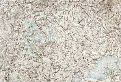
SoldOrdnance Survey.- Environs of LondonOrdnance Survey.- Environs of London,reduced ordnance map of London, engraving with original hand-colouring, 710 x 820mm., linen-backed, surface dirt, some tears along folds, folding into greeSee Sold Price
SoldLondon.- Ordnance Survey.- Mudge (Lt. Col. William)London.- Mudge (Lt. Col. William) Four Ordnance Survey maps covering the environs of London, numbered I, VI, VII, and VIII, showing from Great Marlow to the mouth of the River Medway, and East GrinsteSee Sold Price
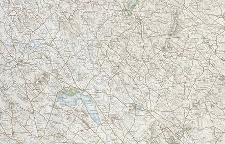
Ordnance Survey.- London and Its EnvironsOrdnance Survey.- London and Its Environs,showing from Potters Bar down to Epsom, and Gravesend across to Windsor, engraved map with principal railways marked in colour, 715 x 1150mm., dissectSee Sold Price
Ordnance Survey.- London and Its EnvironsOrdnance Survey.- London and Its Environs,showing from Potters Bar down to Epsom, and Gravesend across to Windsor, engraved map with some hand-colouring, 715 x 1150mm., dissected and linen-bacSee Sold Price
SoldCruchley (G F) Environs of LondonCruchley (G F) [Environs of London] from the Ordnance Survey of the Country Thirty Miles round London, from Hertford to Godalming and Tunbridge, and from Maidenhead to Chatham, showing extensiSee Sold Price
SoldOrdnance Survey.- London and its western environsOrdnance Survey.- London and its western environs,showing from Hurley and Maidenhead to Greenwich and East London, engraved map, some hand-colouring, 715 x 1010mm., dissected and linen-backed,See Sold Price
SoldLondon - Stanford, Edward C1860 Large Folding Map"Map of the Environs of London Reduced from the Ordnance Survey" Steel Engraved Map Published C1860, London by Edward Stanford. Reduced from the Ordnance Survey. Fine original hand colour. Contained iSee Sold Price
SoldLondon.- Philip (George, & Son) Philip's New Map ofLondon.- Philip (George, & Son) Philip's New Map of London and It's Environs, from the New Ordnance Survey including the area under the jurisdiction of the Metropolitan Board of Works, showing from ChSee Sold Price
SoldLondon.- Cruchley (George Frederick) From the OrdnanceLondon.- Cruchley (George Frederick) From the Ordnance Survey of the Country Thirty Miles round London, map of the environs of London showing from Hertford to Godalming and Tunbridge, and from MaidenhSee Sold Price
London.- Cruchley (George Frederick) From the OrdnanceLondon.- Cruchley (George Frederick) From the Ordnance Survey of the Country Thirty Miles round London, map of the environs of London showing from Hertford to Godalming and Tunbridge, and from MaidenhSee Sold Price
SoldLondon.- Trench (Capt. the Hon. W. Le Poer) Hyde ParkLondon.- Trench (Capt. the Hon. W. Le Poer) Hyde Park from Sheet VI.11.12.15.16 of the Ordnance Survey of London, showing the area from Bayswater Road in the north to Rutland Gate in the south, lithogSee Sold Price
Sold19th century Ordnance Survey map of South London includ19th century Ordnance Survey map of South London including Greenwich and Woolwich, published 1872See Sold Price
SoldBLON Wallis (John)BLON Wallis (John) A New and Accurate Topographical Survey of the Environs of London.....within Twenty Miles of the Metropolis, from Ware to Dorking, and from Beaconsfield to Chelmsford, engraSee Sold Price
LSE POVERTY OS PROOF MAP Swiss Cottage. West/South Hampstead. Belsize Park 1928Title: LSE POVERTY OS PROOF MAP Swiss Cottage. West/South Hampstead. Belsize Park 1928 Description: [Ordnance Survey] Edition of 1915 - London Sheet IV. 4. Middlesex Sheet XVI. 4. Swiss Cottage - SoutSee Sold Price
London.- Wallis (John) A New and Accurate TopographicalLondon.- Wallis (John) & John Cary. A New and Accurate Topographical Survey of the Environs of London, within Twenty Miles of the Metropolis, from Ware to Dorking, and from Beaconsfield to Chelmsford,See Sold Price
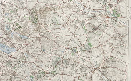
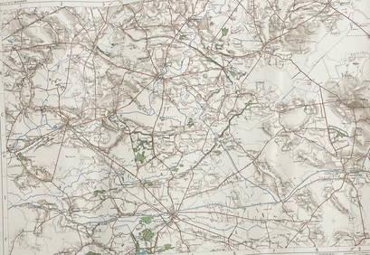
SoldEast Midlands.- Colby (Lt. Col. Thomas) [Six OrdnanceNO RESERVE East Midlands.- Colby (Lt. Col. Thomas) [Six Ordnance survey maps covering the environs of Lincoln and Rutland], including sheets LXIV, LXIX, LXXXIII, LXXXIV, LXXXV, and LXXXVI, engravings,See Sold Price
LSE POVERTY OS PROOF MAP St Johns Wood Maida Vale Lisson Grove Regents Park 1928Title: LSE POVERTY OS PROOF MAP St Johns Wood Maida Vale Lisson Grove Regents Park 1928 Description: [Ordnance Survey] Edition of 1915 - London Sheet IV. 8. - Middlesex Sheet XVI. 8. St John's Wood -See Sold Price
LSE POVERTY OS PROOF MAP Hackney Downs - Kingsland - Dalston - Haggerston 1928Title: LSE POVERTY OS PROOF MAP Hackney Downs - Kingsland - Dalston - Haggerston 1928 Description: [Ordnance Survey] Edition of 1916 - London Sheet V. 3. Hackney - Kingsland - Dalston - Haggerston bySee Sold Price
LSE POVERTY OS PROOF MAP Holland Park Shepherds Bush Olympia Hammersmith 1928Title: LSE POVERTY OS PROOF MAP Holland Park Shepherds Bush Olympia Hammersmith 1928 Description: [Ordnance Survey] Edition of 1916 - London Sheet IV. 15. Holland Park - Shepherds Bush - Kensington -See Sold Price
Benjamin Baker (second-quarter, 19th century), after, aBenjamin Baker (second-quarter, 19th century), after, a twenty-one fold map, of the border of Derbyshire, Nottinghamshire and Leicestershire, Published at the Ordnance Survey Office, Tower of London,See Sold Price
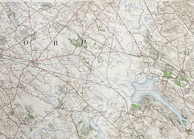
Ordnance Map of the S.W. Environs of London. [CaseMap: Ordnance Map of the S.W. Environs of London. [Case Title] Publication Date: 1904 Cartographer: ORDNANCE SURVEY Publisher: EDWARD STANFORD Size (inches): 25.25X38.75 Imprint label on margin readinSee Sold Price
ORDNANCE SURVEYORDNANCE SURVEY A collection of approximately 250 Ordnance Survey Maps, mostly of Edinburgh and environs 1943-54. Scale: 1: 1250 or 50-688 inches 1 mile, but with 7 of the 1931-32 revision scale 25.34See Sold Price
SoldMONTRESOR, John (1736-1799). A Plan of the City of New-MONTRESOR, John (1736-1799). A Plan of the City of New-York & its Environs… Survey’d in the Winter, 1775. London: A. Dury, [1775]. Hand-colored copper-engraved map with inset plan of New York HarbSee Sold Price
UK C1830-1948 Mixed Lot of 6 MapsEngraved and Lithographed Maps. Incl Staffordshire, Huddersfield, Navigable Rivers, Buckingham, London and England. Examples by Ordnance Survey, Sidney Hall, Encyclopaedia Britannica, National EncycloSee Sold Price
BOTH TITLE PAGES OF COLLINS" COASTAL SURVEY, 1776, IN MATCHING FRAMESThomaston Place Auction Galleries4.4(386)See Sold PriceFeb 24, 2024
[MAP]. NICHOLLS, Sutton (1668-1729). An Epitome of Sr. Will...Potter & Potter Auctions4.6(539)See Sold PriceMar 07, 2024
D'Oyly (Calcutta, India) - Government House from St. Andrew's LibraryTrillium Antique Prints & Rare Books4.5(30)See Sold PriceFeb 24, 2024
D'Oyly (Calcutta, India) - Procession of the CurruckpoojaTrillium Antique Prints & Rare Books4.5(30)See Sold PriceFeb 24, 2024
Book: A Survey of the Cities of London and Westminster, Borough of Southwark and Parts Adjacent,Claydon Auctioneers Ltd4.3(125)See Sold PriceFeb 26, 2024
Nottingham.- Ordnance Survey Office (publisher) Collection 8 geological maps on the environs ofForum Auctions4.3(52)See Sold PriceFeb 29, 2024
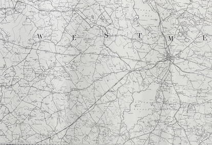
ORDNANCE SURVEY OF IRELAND/ Sheet No. 79/ CAVAN, LEITRIM, LONGFORD, MEATH & WESTMEATH Revised 1899Churchill Galleries3.7(213)See Sold PriceFeb 26, 2024
ORDNANCE SURVEY OF IRELAND/ Sheet No. 80/ CAVAN, MEATH & MONAGHAN/ Surveyed 1837 - 39. Printed inChurchill Galleries3.7(213)See Sold PriceFeb 26, 2024
ORDNANCE SURVEY OF IRELAND/ Sheet No. 89/ LONGFORD, MEATH & WESTMEATH/ Published in 1903Churchill Galleries3.7(213)See Sold PriceFeb 26, 2024
ORDNANCE SURVEY OF IRELAND/ Sheet No. 89/ LONGFORD, MEATH & WESTMEATH/ Published in 1903Churchill Galleries3.7(213)See Sold PriceFeb 26, 2024
ORDNANCE SURVEY OF IRELAND/ Sheet No. 89/ LONGFORD, MEATH & WESTMEATH/ Published in 1903Churchill Galleries3.7(213)See Sold PriceFeb 26, 2024
ORDNANCE SURVEY OF IRELAND/ Sheet No. 89/ LONGFORD, MEATH & WESTMEATH/ Published in 1903Churchill Galleries3.7(213)See Sold PriceFeb 26, 2024
ORDNANCE SURVEY OF IRELAND/ Sheet No.90/ MEATH & WESTMEATH/ Published in 1903Churchill Galleries3.7(213)See Sold PriceFeb 26, 2024
ORDNANCE SURVEY OF IRELAND/ Sheet No.90/ MEATH & WESTMEATH/ Published in 1903Churchill Galleries3.7(213)See Sold PriceFeb 26, 2024
ORDNANCE SURVEY OF IRELAND/ Sheet No.90/ MEATH & WESTMEATH/ Published in 1903Churchill Galleries3.7(213)See Sold PriceFeb 26, 2024
ORDNANCE SURVEY OF IRELAND/ Sheet No.90/ MEATH & WESTMEATH/ Published in 1903Churchill Galleries3.7(213)See Sold PriceFeb 26, 2024
ORDNANCE SURVEY OF IRELAND/ Sheet No.90/ MEATH & WESTMEATH/ Published in 1903Churchill Galleries3.7(213)See Sold PriceFeb 26, 2024
ORDNANCE SURVEY OF IRELAND/ Sheet No.99/ KILDARE, MEATH, KINGS & WESTMEATH/ Published in 1902Churchill Galleries3.7(213)See Sold PriceFeb 26, 2024
ORDNANCE SURVEY OF IRELAND/ Sheet No.100/ KILDARE, MEATH & WESTMEATH/ Published in 1903Churchill Galleries3.7(213)See Sold PriceFeb 26, 2024
ORDNANCE SURVEY OF IRELAND/ Sheet No.100/ KILDARE, MEATH & WESTMEATH/ Published in 1903Churchill Galleries3.7(213)See Sold PriceFeb 26, 2024
ORDNANCE SURVEY OF IRELAND/ Sheet No.100/ KILDARE, MEATH & WESTMEATH/ Published in 1903Churchill Galleries3.7(213)See Sold PriceFeb 26, 2024
ORDNANCE SURVEY OF IRELAND/ Sheet No.100/ KILDARE, MEATH & WESTMEATH/ Published in 1903Churchill Galleries3.7(213)See Sold PriceFeb 26, 2024
ORDNANCE SURVEY OF IRELAND/ Sheet No.100/ KILDARE, MEATH & WESTMEATH/ Published in 1903Churchill Galleries3.7(213)See Sold PriceFeb 26, 2024
ORDNANCE SURVEY OF IRELAND/ SHEET NO.109/ KING CO. & CO. WESTMEATH. / PUBLISHED IN 1900Churchill Galleries3.7(213)See Sold PriceFeb 26, 2024


![[MAP]. NICHOLLS, Sutton (1668-1729). An Epitome of Sr. Will... (1 of 1)](https://p1.liveauctioneers.com/928/318880/171361281_1_x.jpg?height=282&quality=70&version=1707501302)