ATLAS of ANTIENT GEOGRAPHY by SAMUEL BUTLER 1843John McInnis Auctioneers,LLC4.6(502)See Sold PriceFeb 24, 2024
18TH C. ANTIQUE MAP: FRENCH & INDIAN WAR, FRAMEDThomaston Place Auction Galleries4.4(386)See Sold PriceFeb 24, 2024
Rand McNally Railroad Map Cabinet w/ 21 Railroad MapsRail & Road Auctions4.6(165)See Sold PriceMar 08, 2024
Keith Haring - Ink on New York Map, Best Buddies, Inscribed, Signed, and DatedSapphire Auction Gallery4(67)See Sold PriceMar 02, 2024
LATE 17TH C. FRENCH MAP OF THE NEW WORLD BY ALEXIS-HUBERT JAILLOT (1632-1712)Thomaston Place Auction Galleries4.4(386)See Sold PriceFeb 24, 2024
Central Railroad of New Jersey Map of Sandy Hook Route-ca. 1903JM Hobby Supply and Railroad Artifact Auctions4.4(126)See Sold PriceFeb 24, 2024
Lot of Six Mixed Atlas Box Cars-HO Scale-New in BoxJM Hobby Supply and Railroad Artifact Auctions4.4(126)See Sold PriceFeb 25, 2024
Rand McNally/Santa Fe Railroad Map of Iowa-1912JM Hobby Supply and Railroad Artifact Auctions4.4(126)See Sold PriceFeb 24, 2024
NICOLAES VISSCHER (NETHERLANDS, 1618-1709) MAP OF THE NEW WORLDThomaston Place Auction Galleries4.4(386)See Sold PriceFeb 24, 2024
17TH C. WORLD MAP BY NICOLAES VISSCHER (NETHERLANDS, 1618-1709)Thomaston Place Auction Galleries4.4(386)See Sold PriceFeb 24, 2024
Lot of Six Mixed Atlas Cabooses-HO Scale-New in BoxJM Hobby Supply and Railroad Artifact Auctions4.4(126)See Sold PriceFeb 25, 2024
1859 Map of Washington State, Oregon and IdahoTitle: 1859 Map of Washington State, Oregon and Idaho Author: Johnson Medium: Ink on Paper Dimensions: 18"X14.5" Map of Washington state, Oregon and Idaho dated 1859. Engraved by A.J. Johnson. PublishSee Sold Price
Sold1859 Map of Washington state, Oregon and IdahoAuthor: Johnson Title: 1859 Map of Washington state, Oregon and Idaho Medium: Ink on Paper Dimensions: 18"X14.5" Map of Washington state and Oregon dated 1859. Engraved by A.J. Johnson. Published by JSee Sold Price
1859 Map of Washington State, Oregon and IdahoAuthor: Johnson Title: 1859 Map of Washington State, Oregon and Idaho Medium: Ink on Paper Dimensions: 18"X14.5" Description: Map of Washington state, Oregon and Idaho dated 1859. Engraved by A.J. JohSee Sold Price
1859 Map of Washington State, Oregon and IdahoAuthor: Johnson Title: 1859 Map of Washington State, Oregon and Idaho Medium: Ink on Paper Dimensions: 18"X14.5" Map of Washington state, Oregon and Idaho dated 1859. Engraved by A.J. Johnson. PublishSee Sold Price
1859 Map of Washington State and OregonAuthor: Johnson Title: 1859 Map of Washington State and Oregon Materials: Ink on Paper Dimensions: 18"X14.5" Description: Map of Washington state and Oregon dated 1859. Engraved by A.J. Johnson. PubliSee Sold Price
1859 Map of Washington, Oregon and IdahoAuthor: Johnson Title: 1859 Map of Washington, Oregon and Idaho Medium: Ink on Paper Dimensions: 18"X14.5" Map of Washington state, Oregon and Idaho dated 1859. Engraved by A.J. Johnson. Published bySee Sold Price
United States of North America, Pacific States by Joseph Wilson Lowry 1859 mapTitle: United States of North America, Pacific States by Joseph Wilson Lowry 1859 map Description: The United States of North America, Pacific States [including California, Oregon, Washington, Utah, aSee Sold Price
SoldColton: Antique Map of Washington Oregon, 1859Title/Content of Map: Washington Oregon by Colton Date Printed: 1859 Cartographer: H. J. Colton Material/Medium: Paper Size: 17 1/2" x 15" Hand colored engraved. Published in New York in 'Colton's GenSee Sold Price
SoldTHIRTEEN NINETEENTH CENTURY PRINTS, many hand coloTHIRTEEN NINETEENTH CENTURY PRINTS, many hand colored, including 9 various maps of western United States areas (Washington state, Seattle, Oregon, California); 4 wild life prints including pack of hunSee Sold Price
SoldJohnson’s Map of Washington & Oregon, 18631863 Map of Johnson’s Washington and Oregon. Johnson & Ward. 12.5 x 15.5 inches. Glimpse of this region shortly following the outbreak of the Civil War. Shows the state of Oregon with much of its eaSee Sold Price
State of OregonTitle: State of Oregon Publication Date: 1884 Cartographer: STRUM, G.P./JULIUS BIEN & CO. Publisher: G.L.O./DEPT. OF INTERIOR Size: 23.4X30 Large Official General Land Office Map of Washington in 1884See Sold Price
SoldMap of Washington Territory, 1859Map: 1859 Washington Territory Map -- Map of a Part of Washington Territory to Accompany the report of the Surveyor General Cartographer: US State Surveys (J Tilton) Year / Place: 1859 Washington MapSee Sold Price
SoldHood's map of Oregon Territory 1838Heading: Author: Hood, Washington, editor Title: Map of the United States Territory of Oregon West of the Rocky Mountains: Exhibiting the Various Trading Depots or Forts Occupied by the British HudsoSee Sold Price
SoldMap of WA, OR, and Territory of Alaska (124635)One page, 18 x 15 inches, with maps of the states of Washington and Oregon and a map of the Territory of Alaska published by Warner & Beers. Must post-date the incorporation of the Territory of AlaskaSee Sold Price
SoldRARE Hand colored map by Charles DeSilver c. 1859RARE original hand colored map of California and the territories of Oregon, Washington, Utah and New Mexico, by Charles DeSilver, in frame, circa 1859, image measuring 16.75" xSee Sold Price
Scarce 1847 map of Western Terr. Of the U. S.Great and uncommon map showing the transitional boundaries of the American West c1840s. massive Oregon Territory, encompassing future states of Washington and Idaho, and extreme western portion of MonSee Sold Price
(Pacific States) California, Nevada, Oregon,Reserve Reduced! Title: (Pacific States) California, Nevada, Oregon, Washington, Idaho, Utah, Arizona and Part of Montana. Publication Date: 1890 Cartographer: BARTHOLOMEW, JOHN & CO. Publisher: MACMISee Sold Price
BRITISH NORTH AMERICA. Washington state shown asTITLE/CONTENT OF MAP: 'BRITISH NORTH AMERICA' The map shows the border between the United States and British North America (now Canada) as it was before the Oregon Treaty of 1846, and it shows what isSee Sold Price
BRITISH NORTH AMERICA. Washington state shown asTITLE/CONTENT OF MAP: 'BRITISH NORTH AMERICA' The map shows the border between the United States and British North America (now Canada) as it was before the Oregon Treaty of 1846, and it shows what isSee Sold Price
SoldTwo American 19thC MapsTwo American 19thC Maps, A) 19thC map of United States western states, including California, Oregon, Utah, Washington, New Mexico, Nebraska, Kansas, Indian Territory, framed and matted under glass, siSee Sold Price
USA West. Oregon Utah Washington New Mexico Nebraska Kansas Territories 1862 mapTitle: USA West. Oregon Utah Washington New Mexico Nebraska Kansas Territories 1862 map Description: United States - Western States, including California, Oregon, Utah, Washington, New Mexico, NebraskSee Sold Price
SoldScarce 1853 map from Colton’s 1856 Atlas of the WorldReserve Reduced! An attractive and scarce 1853 Colton map of Washington and Oregon, inclusive of the modern-day states of Idaho, Montana & Wyoming. This map appeared in the 1856 Colton 2-volume AtlasSee Sold Price
SoldBlack (A & C) United States, Western StatesBlack (A & C) United States, Western States, including California, Oregon, Utah, Washington, New Mexico, Nebraska, Kansas, Indian Territory, &c.,engraved map printed in colours, 415 x 560mm.,See Sold Price
Sold1863 Johnson’s Washington and OregonImportant map, striking in its transitional representation. Fascinating glimpse of this region shortly following the outbreak of the Civil War. Shows the state of Oregon with much of its eastern regioSee Sold Price
Northern Pacific RR Washington and Northern Idaho Map Folder-1941JM Hobby Supply and Railroad Artifact Auctions4.4(126)See Sold PriceFeb 24, 2024
Rand McNally Railroad Map of Washington-1906JM Hobby Supply and Railroad Artifact Auctions4.4(126)See Sold PriceFeb 24, 2024
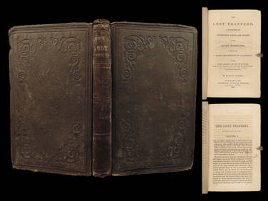
1859 Lost Trappers Rocky Mountains California Fur Trade Western Frontier ExploreSchilb Antiquarian Rare Books4.8(421)See Sold PriceMar 31, 2024
[BUSINESS]. Travel Guide of Negro Hotels and Guest Houses. Published by Afro-American Newspapers ofFreeman's | Hindman4.4(1.6k)See Sold PriceFeb 27, 2024
Mitchell - Map of the City of Washington (Washington, DC)Trillium Antique Prints & Rare Books4.5(30)See Sold PriceFeb 24, 2024
Goode, George Brown 1884 Lot of 4 Natural History & Meteorology MapsAlbion Auctions4.6(336)See Sold PriceMar 01, 2024
Francis McNally - Antique Map of Washington, Oregon, Idaho, Nevada, Utah & ArizonaProverde Auctions4.3(3)See Sold PriceFeb 28, 2024
[Spokane, Washington State] Maps, Pins & More (8)Grant Zahajko Auctions, LLC4.8(1k)See Sold PriceMar 06, 2024


![[BUSINESS]. Travel Guide of Negro Hotels and Guest Houses. Published by Afro-American Newspapers of (1 of 4)](https://p1.liveauctioneers.com/197/319238/171467937_1_x.jpg?height=282&quality=70&version=1707520367)


![[Spokane, Washington State] Maps, Pins & More (8) (1 of 5)](https://p1.liveauctioneers.com/5755/320282/172114031_1_x.jpg?height=282&quality=70&version=1708463029)
