ATLAS of ANTIENT GEOGRAPHY by SAMUEL BUTLER 1843John McInnis Auctioneers,LLC4.6(504)See Sold PriceFeb 24, 2024
18TH C. ANTIQUE MAP: FRENCH & INDIAN WAR, FRAMEDThomaston Place Auction Galleries4.4(389)See Sold PriceFeb 24, 2024
Rand McNally Railroad Map Cabinet w/ 21 Railroad MapsRail & Road Auctions4.6(165)See Sold PriceMar 08, 2024
Keith Haring - Ink on New York Map, Best Buddies, Inscribed, Signed, and DatedSapphire Auction Gallery4.1(67)See Sold PriceMar 02, 2024
LATE 17TH C. FRENCH MAP OF THE NEW WORLD BY ALEXIS-HUBERT JAILLOT (1632-1712)Thomaston Place Auction Galleries4.4(389)See Sold PriceFeb 24, 2024
Central Railroad of New Jersey Map of Sandy Hook Route-ca. 1903JM Hobby Supply and Railroad Artifact Auctions4.4(126)See Sold PriceFeb 24, 2024
Lot of Six Mixed Atlas Box Cars-HO Scale-New in BoxJM Hobby Supply and Railroad Artifact Auctions4.4(126)See Sold PriceFeb 25, 2024
Rand McNally/Santa Fe Railroad Map of Iowa-1912JM Hobby Supply and Railroad Artifact Auctions4.4(126)See Sold PriceFeb 24, 2024
NICOLAES VISSCHER (NETHERLANDS, 1618-1709) MAP OF THE NEW WORLDThomaston Place Auction Galleries4.4(389)See Sold PriceFeb 24, 2024
17TH C. WORLD MAP BY NICOLAES VISSCHER (NETHERLANDS, 1618-1709)Thomaston Place Auction Galleries4.4(389)See Sold PriceFeb 24, 2024
Lot of Six Mixed Atlas Cabooses-HO Scale-New in BoxJM Hobby Supply and Railroad Artifact Auctions4.4(126)See Sold PriceFeb 25, 2024
Sold1862 Map of Virginia Printed in Richmond. 36.5"1862 Map of Virginia Printed in Richmond. 36.5" x 25.5" map titled: "Map of the State of Virginia Containing the Counties, Principal Towns, Railroads, Rivers, Canals & All Other Internal ImprovemeSee Sold Price
1862 Map of Virginia1862, "JOHNSON'S MAP OF THE VICINITY OF RICHMOND, AND PENINSULAR CAMPAIGN IN VIRGINIA," Printed by J. Knowles, NY, Choice Very Fine. 17.75" x 27," hand-tinted, two-color map of the Union Army's CivilSee Sold Price
Sold1862 Map of VirginiaMaps1862, “JOHNSON’S MAP OF THE VICINITY OF RICHMOND, AND PENINSULAR CAMPAIGN IN VIRGINIA,” Printed by J. Knowles, NY, Choice Very Fine. 17.75” x 27,” hand-tinted, two-coSee Sold Price
1862 Map of Virginia, J. Knowles1862, “JOHNSON’S MAP OF THE VICINITY OF RICHMOND, AND PENINSULAR CAMPAIGN IN VIRGINIA,” Printed by J. Knowles, NY, Choice Very Fine. 18.25” x 27.5” two-color map of the USee Sold Price
Sold1862, JOHNSONS CIVIL WAR MAP OF VIRGINIAMaps1862, “JOHNSON’S MAP OF THE VICINITY OF RICHMOND, AND PENINSULAR CAMPAIGN IN VIRGINIA,” Printed by J. Knowles, NY, Choice Very Fine. 18.25” x 27.5” two-color map of tSee Sold Price
Sold1862, JOHNSONS CIVIL WAR MAP OF VIRGINIAMaps1862, "JOHNSON'S MAP OF THE VICINITY OF RICHMOND, AND PENINSULAR CAMPAIGN IN VIRGINIA," Printed by J. Knowles, NY, Choice Very Fine. 18.25" x 27.5" two-color map of the Union ASee Sold Price
Sold1862, JOHNSONS CIVIL WAR MAP OF VIRGINIAMaps1862, “JOHNSON’S MAP OF THE VICINITY OF RICHMOND, AND PENINSULAR CAMPAIGN IN VIRGINIA,” Printed by J. Knowles, NY, Choice Very Fine. 18.25” x 27.5” two-color map of tSee Sold Price
Sold1862, JOHNSON'S CIVIL WAR MAP OF VIRGINIAMaps1862, “JOHNSON’S MAP OF THE VICINITY OF RICHMOND, AND PENINSULAR CAMPAIGN IN VIRGINIA,” Printed by J. Knowles, NY, Choice Very Fine. 18.25” x 27.5” two-color map of the Union Army’s CiSee Sold Price
Sold1862, JOHNSONS CIVIL WAR MAP OF VIRGINIA"Maps1862, “JOHNSON’S MAP OF THE VICINITY OF RICHMOND, AND PENINSULAR CAMPAIGN IN VIRGINIA,” Printed by J. Knowles, NY, Choice Very Fine. 18.25” x 27.5” two-color map ofSee Sold Price
Sold1862, JOHNSONS CIVIL WAR MAP OF VIRGINIAMaps1862, “JOHNSON’S MAP OF THE VICINITY OF RICHMOND, AND PENINSULAR CAMPAIGN IN VIRGINIA,” Printed by J. Knowles, NY, Choice Very Fine. 18.25” x 27.5” two-color map of tSee Sold Price
Sold1862, JOHNSONS CIVIL WAR MAP OF VIRGINIAMaps1862, “JOHNSON’S MAP OF THE VICINITY OF RICHMOND, AND PENINSULAR CAMPAIGN IN VIRGINIA,” Printed by J. Knowles, NY, Choice Very Fine. 18.25” x 27.5” two-color map of tSee Sold Price
Sold1862, JOHNSONS CIVIL WAR MAP OF VIRGINIAMaps1862, “JOHNSON’S MAP OF THE VICINITY OF RICHMOND, AND PENINSULAR CAMPAIGN IN VIRGINIA,” Printed by J. Knowles, NY, Choice Very Fine. 18.25” x 27.5” two-color map of tSee Sold Price
Sold1862, JOHNSONS CIVIL WAR MAP OF VIRGINIAMaps1862, “JOHNSON’S MAP OF THE VICINITY OF RICHMOND, AND PENINSULAR CAMPAIGN IN VIRGINIA,” Printed by J. Knowles, NY, Choice Very Fine. 18.25” x 27.5” two-color map of tSee Sold Price
Sold1862, JOHNSONS CIVIL WAR MAP OF VIRGINIAHistoric Maps1862, "JOHNSON'S MAP OF THE VICINITY OF RICHMOND, AND PENINSULAR CAMPAIGN IN VIRGINIA," Printed by J. Knowles, NY, Choice Very Fine. 18.25" x 27.5" two-color map of thSee Sold Price
Sold1862, JOHNSONS CIVIL WAR MAP OF VIRGINIAHistoric Maps1862, "JOHNSON'S MAP OF THE VICINITY OF RICHMOND, AND PENINSULAR CAMPAIGN IN VIRGINIA," Printed by J. Knowles, NY, Choice Very Fine. 18.25" x 27.5" two-color map of thSee Sold Price
Sold1862, JOHNSONS CIVIL WAR MAP OF VIRGINIAHistoric Maps1862, "JOHNSON'S MAP OF THE VICINITY OF RICHMOND, AND PENINSULAR CAMPAIGN IN VIRGINIA," Printed by J. Knowles, NY, Choice Very Fine. 18.25" x 27.5" two-color map of thSee Sold Price
Sold1862, JOHNSONS CIVIL WAR MAP OF VIRGINIAMaps1862, “JOHNSON’S MAP OF THE VICINITY OF RICHMOND, AND PENINSULAR CAMPAIGN IN VIRGINIA,” Printed by J. Knowles, NY, Choice Very Fine. 18.25” x 27.5” two-color map of tSee Sold Price
1862 Johnson Map of Civil War Virginia East of Richmond -- Johnson's Map of the Vicinity ofTitle: 1862 Johnson Map of Civil War Virginia East of Richmond -- Johnson's Map of the Vicinity of Richmond, and Peninsular Campaign in Virginia Cartographer: Johnson & Ward Year / Place: 1862, New YoSee Sold Price
1862 Johnson Map of Civil War Virginia East of RichmondTitle: 1862 Johnson Map of Civil War Virginia East of Richmond -- Johnson's Map of the Vicinity of Richmond, and Peninsular Campaign in Virginia Cartographer: Johnson & Ward Year / Place: 1862, New YoSee Sold Price
Sold1862 Map of Virginia Battlefields: Johns1862 Map of Virginia Battlefields: Johnson's Map of the Vicinity of Richmond & Peninsula Campaign in Virginia. In Excellent Condition, Framed & Matted to 24"x 32 1/2".See Sold Price
Sold1862 Map of Eastern Virginia Nicholson, W.L.Nicholson, W.L., cop. Map of eastern Virginia compiled from the best authorities and printed after the Coast Survey Office, lihtograph. Washington, D.C.: W.H. and O.H. Morrison, 1862Fifty mile scaleDiSee Sold Price
SoldAn 1841 Map of Virginia,"The Geology by Prof. William B. Rogers, Chiefly from the State Survey 1835-'41", printed in Richmond, VA. Mounted and gilt framed under glass, 11 3/4" high, 23 3/4" wide. Some damage.See Sold Price
SoldMap of Richmond, Virginia by Johnson, 1862 (James,Johnson’s Map of the Vicinity of Richmond, and Peninsular Campaign in Virginia Showing also the interesting localities along the James, Chickahominy and York Rivers. Compiled from the official mapsSee Sold Price
SoldJohnson: Antique Civil War Map of Richmond, 1862Scarce and important 1862 A. J. Johnson map of the vicinity of Richmond, Virginia, during the American Civil War. Full title: “Johnson’s Map of the Vicinity of Richmond, and Peninsular CaSee Sold Price
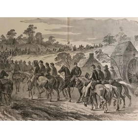
19thc Civil War Engraving, Cavalry Raid, Libby Prison, Richmond VirginiaConnoisseur Auctions3.9(335)See Sold PriceMar 02, 2024
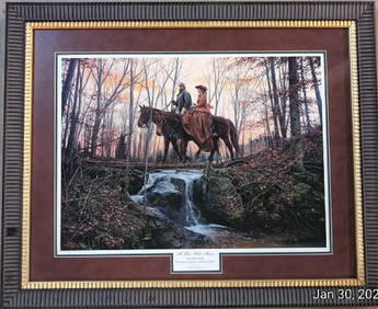
Civil War print by John Paul Strain ltd. edt.Heritage Antiques & Auction4.1(90)See Sold PriceMar 02, 2024
Pair of Early Railroad Maps - 1862 Pittsburgh, Ft. Wayne & Chicago Railway and 1873 PennsylvaniaRail & Road Auctions4.6(165)See Sold PriceMar 07, 2024
Collection of Allied Military Silk Printed Maps, WWII Era and LaterMaterial Culture4.6(769)See Sold PriceFeb 29, 2024
Rand McNally Railroad Map Cabinet w/ 21 Railroad MapsRail & Road Auctions4.6(165)See Sold PriceMar 08, 2024
July 21 $1 1862 Richmond Virginia Haxby# OBSVACR17 PMG AU58 EPQMynt Auctions4.6(689)See Sold PriceFeb 24, 2024
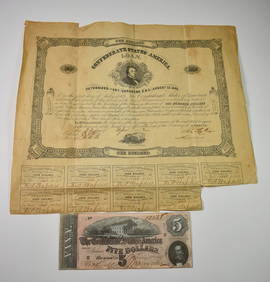
[CIVIL WAR]. Manuscript Printed Confederate Soldier’s Disch...Potter & Potter Auctions4.6(544)See Sold PriceMar 07, 2024
[CIVIL WAR]. MCPHERSON, James Bird Brigadier General (1828-...Potter & Potter Auctions4.6(544)See Sold PriceMar 07, 2024
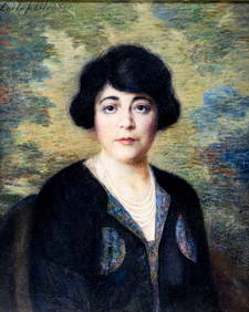
Carle Blenner (NY,CT,1862-1952) oil paintingBroward Auction Gallery4.8(285)See Sold PriceMay 05, 2024
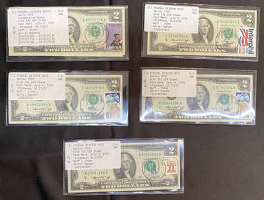
TEN $2 BILLS STAMPED JULY 4, 1976 FROM RICHMOND, VA. 6 ARE CONSECUTIVELY NUMBEREDThe Rug Life4.3(12)See Sold PriceMar 07, 2024
Putnam - First Map of the State of Ohio by Rufus PutnamTrillium Antique Prints & Rare Books4.5(30)See Sold PriceFeb 24, 2024
"Map of the Parishes of Iberville Most of West Baton Rouge and Including Parts of the Parishes ofCrescent City Auction Gallery4.3(231)See Sold PriceMar 09, 2024
Theodor Fischer (1862 - 1938) - Set of 4 Bird Prints - Haliaetos Albicilla - Strix LapponicaProverde Auctions4.3(3)See Sold PriceFeb 28, 2024
Theodor Fischer (1862 - 1938) - Set of 4 Bird Prints - Pernis Apivorus - Falco ArcticusProverde Auctions4.3(3)See Sold PriceFeb 28, 2024


![[REES, Charles] Enlistedman w/ Bowie Knife (1 of 1)](https://p1.liveauctioneers.com/7226/317626/170485489_1_x.jpg?height=282&quality=70&version=1706368022)


![[CIVIL WAR]. Manuscript Printed Confederate Soldier’s Disch... (1 of 2)](https://p1.liveauctioneers.com/928/318880/171360934_1_x.jpg?height=282&quality=70&version=1707501302)
![[CIVIL WAR]. MCPHERSON, James Bird Brigadier General (1828-... (1 of 2)](https://p1.liveauctioneers.com/928/318880/171360951_1_x.jpg?height=282&quality=70&version=1707501302)