ATLAS of ANTIENT GEOGRAPHY by SAMUEL BUTLER 1843John McInnis Auctioneers,LLC4.5(505)See Sold PriceFeb 24, 2024
18TH C. ANTIQUE MAP: FRENCH & INDIAN WAR, FRAMEDThomaston Place Auction Galleries4.4(393)See Sold PriceFeb 24, 2024
Rand McNally Railroad Map Cabinet w/ 21 Railroad MapsRail & Road Auctions4.6(165)See Sold PriceMar 08, 2024
Keith Haring - Ink on New York Map, Best Buddies, Inscribed, Signed, and DatedSapphire Auction Gallery4.1(67)See Sold PriceMar 02, 2024
LATE 17TH C. FRENCH MAP OF THE NEW WORLD BY ALEXIS-HUBERT JAILLOT (1632-1712)Thomaston Place Auction Galleries4.4(393)See Sold PriceFeb 24, 2024
Central Railroad of New Jersey Map of Sandy Hook Route-ca. 1903JM Hobby Supply and Railroad Artifact Auctions4.4(127)See Sold PriceFeb 24, 2024
Lot of Six Mixed Atlas Box Cars-HO Scale-New in BoxJM Hobby Supply and Railroad Artifact Auctions4.4(127)See Sold PriceFeb 25, 2024
Rand McNally/Santa Fe Railroad Map of Iowa-1912JM Hobby Supply and Railroad Artifact Auctions4.4(127)See Sold PriceFeb 24, 2024
NICOLAES VISSCHER (NETHERLANDS, 1618-1709) MAP OF THE NEW WORLDThomaston Place Auction Galleries4.4(393)See Sold PriceFeb 24, 2024
17TH C. WORLD MAP BY NICOLAES VISSCHER (NETHERLANDS, 1618-1709)Thomaston Place Auction Galleries4.4(393)See Sold PriceFeb 24, 2024
Lot of Six Mixed Atlas Cabooses-HO Scale-New in BoxJM Hobby Supply and Railroad Artifact Auctions4.4(127)See Sold PriceFeb 25, 2024
(C No. 3) Preliminary Chart of Delaware and ChesapeakeTitle/Content of Map: (C No. 3) Preliminary Chart of Delaware and Chesapeake Bays and the Sea Coast from Cape Henlopen to Cape Charles Cartographer: HASSLER, F.R./A. BOSCHKE Date: 1855 Publisher: U.S.See Sold Price
SoldThree Framed Maps of Delaware/Chesapeake BaysPreliminary Chart of Delaware and Chesapeake Bays and the Sea Coast from Cape Henlopen to Cape Charles, Coast Survey Office, 1855, including tide chart and sailing directions, colored highlights, withSee Sold Price
(C No. 3) Preliminary Sketch Showing the Soundings OffPublication Date: 1850 Title: (C No. 3) Preliminary Sketch Showing the Soundings Off the Sea Coast of Delaware and Maryland... 1850 Cartographer: LEE, S.P. Publisher: U.S. COAST SURVEY Height: 13.8 WiSee Sold Price
(C No. 3) Preliminary Sketch Showing the Soundings OffTitle: (C No. 3) Preliminary Sketch Showing the Soundings Off the Sea Coast of Delaware and Maryland... 1850 Publication Date: 1850 Cartographer: LEE, S.P. Publisher: U.S. COAST SURVEY Height: 13.8 WiSee Sold Price
(C No.2) Preliminary Chart of Part of the Sea Coast OfTitle: (C No.2) Preliminary Chart of Part of the Sea Coast Of Virginia and Entrance to Chesapeake Bay Cartographer:WISE, G. D./J. SEIB Publisher: U.S. COAST SURVEY Height: 27.75 Width: 20.5 "from a trSee Sold Price
Sketch C. Showing the Progress of Section No.3 U.S.Title: Sketch C. Showing the Progress of Section No.3 U.S. Coast Survey 1844 to 1850 [Chesapeake and Delaware Bays] Publication Date: 1850 Cartographer: U.S. COAST SURVEY Publisher: U.S. C. S. Height:See Sold Price
SoldMAPS - Jacksonville & Florida KeysJacksonville, St. Augustine & Florida Keys. U.S. Coast Survey, [Lot of 3] Preliminary Chart of St. John's River Florida from Brown's Creek to Jacksonville [and] Preliminary Chart of Florida Reefs ShowSee Sold Price
Preliminary Chart of Chesapeake Bay.Title: Preliminary Chart of Chesapeake Bay. Cartographer: E. BLUNT, J.E. HILGARD, J.S. WILLIAMS AND D. CUTTS, et al. Date: 1857 Publisher: U.S. COAST SURVEY Size: 29.5Height - 37Width Additional Info:See Sold Price
(C No.4) Preliminary Chart of James River Virginia fromTitle: (C No.4) Preliminary Chart of James River Virginia from Richmond to City Point Including the Appomattox River from Petersburg to the Junction Date: 1855 Cartographer: J. Seib./S.A. Wainwright PSee Sold Price
(C No.4) Preliminary Chart of the James RiverTitle/Content of Map: (C No.4) Preliminary Chart of the James River Cartographer: SEIB, J./S. A. WAINWRIGHT Date: 1855 Publisher: U.S.C.S. Size: 25.25Height - 29.75Width Virginia from Richmond to CitySee Sold Price
(C No.4) Preliminary Chart of James River Virginia fromTitle: (C No.4) Preliminary Chart of James River Virginia from Richmond to City Point Including the Appomattox River from Petersburg to the Junction Cartographer: J. Seib./S.A. Wainwright Publisher: USee Sold Price
General Chart of Delaware and Chesapeake Bays and theReserve Reduced! Title/Content of Map: General Chart of Delaware and Chesapeake Bays and the Seacoast from Cape May to Cape Henry Date: 1866 Cartographer: BACHE, A.D./HASSLER, F.R. Publisher: U.S. COASee Sold Price
Sold18th Century Chart of the Delaware Bay and RiverFramed 18th C. chart of the Delaware Bay and River. From the original by Mr. Fisher of Philadelphia, 1776. 22" x 29".See Sold Price
SoldLot of 4 nautical charts, 3 19th c. blue backs anLot of 4 nautical charts, 3 19th c. blue backs and a Eldridge 1924 Vineyard Sound, all as is - poor conditionSee Sold Price
SoldThree cabinet cards of men with high wheel bicycles.Three cabinet cards of men with high wheel bicycles. a) A man in fancy dress by North, Bainbrdge.[4]. b) A man in uniform with “R.C.C.” on his cap. By Bo Durtha, Delaware, Ohio. [3+] c) A man on aSee Sold Price
SoldChesapeake and Delaware Canal Co Mortgage Loan#479 $500 5% mortgage loan. Inc in PA, DE and MD. Signed by President Horner. Small ink stain, dogear."The Chesapeake & Delaware Canal (C&D Canal) is a 14-mile (22.5 km)-long, 450-foot (137.2 m)-wideSee Sold Price
1908 Rockport Chart1908 Rockport Chart, 12 3/34" c 8 3/4" (sight), in frame 19 1/2" x 15 1/2".See Sold Price
SoldMarion Guthrie, Delaware Chesapeake Canal W/CMarion Guthrie, Delaware Chesapeake Canal W/C. Signed lower right. Signed lower right. Sight Size: 9.5 x 12 in.See Sold Price
Sold(3) Charts by Blunt, Bark 'C. S. Bushnell'Description: 1. 1844 chart by Blunt of the River & Gulf of the St. Lawrence and the Banks Adjacent, 1844 additions to 1852 with inset of Cape Cod Harbor from Cape Cod Light to Province Town(1833). TwoSee Sold Price
SoldPORSCHE Germany '60s, mixed lot 3 pieces, No. 1: salesPORSCHE Germany '60s, mixed lot 3 pieces, No. 1: sales brochure 356 B, 8 pages, with sticky tape strengthened, No. 2: PORSCHE fold-out brochure/color chart 356 C, No. 3: four pages long price list PORSee Sold Price
SoldCarolyn Anderson, (3) LithographsCarolyn Anderson (20th C American), DE artist, (3) lithographs, "Centreville, Delaware", ed 66/750; "Rodney Square", ed 171/400; and "Wilmington Train Station", ed 536/750; largest framed size 25" x 3See Sold Price
SoldDépôt de la Marine. 3 Newfoundland chartsDépôt de la Marine. Publishers.- Plan du Havre de Petit Port; Plan de L'ile et du mouillage de Cod-Roy; Plan du Havre de Lark, 3 charts of the Newfoundland coast, 3 engraved charts, each c.530See Sold Price
SoldHistory of the State of Delaware by Henry C Conrad, 3 vHistory of the State of Delaware by Henry C Conrad, 3 vols, published by the author in 1908, illustrated, with original purchase receipt and letters from the author, together with The Collected EssaysSee Sold Price
SoldFIELDING LUCAS (AMERICAN, 1781-1854) NAUTICAL CHART /FIELDING LUCAS (AMERICAN, 1781-1854) NAUTICAL CHART / MAP OF THE CHESAPEAKE AND DELAWARE BAYS, titled "A Chart / OF THE / CHESAPEAKE / AND / DELAWARE / Bays" in upper left corner, with "COMPILED AND PSee Sold Price
Four Assorted Railroad Coal Shovels-DLW/LV/DH RRs and Lehigh Valley CoalJM Hobby Supply and Railroad Artifact Auctions4.4(127)See Sold PriceFeb 24, 2024
LATE 18TH C. VERY LARGE CHART OF NORTHEAST CANADA BY DES BARRES (1721-1824), 1780, FRAMEDThomaston Place Auction Galleries4.4(393)See Sold PriceFeb 24, 2024
LARGE LATE 17TH C. DUTCH CHART OF CANADA, GREAT LAKES, NEW FRANCE, LABRADOR, HUDSON BAY, BY PIERREThomaston Place Auction Galleries4.4(393)See Sold PriceFeb 24, 2024
(2) CHINESE EXPORT TRAYS and a GRAVY BOATJohn McInnis Auctioneers,LLC4.5(505)See Sold PriceFeb 25, 2024
PAIR OF (Early 20th c) ITALIAN FAIENCE COMPOTESJohn McInnis Auctioneers,LLC4.5(505)See Sold PriceFeb 25, 2024
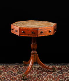
(19th c) ENGLISH OCTAGONAL (4) DRAWER STANDJohn McInnis Auctioneers,LLC4.5(505)See Sold PriceFeb 25, 2024
(Early 19th c) COALPORT PORCELAIN FRUIT COOLERSJohn McInnis Auctioneers,LLC4.5(505)See Sold PriceFeb 25, 2024
PAIR OF CHINESE EXPORT VEGETABLE DISHES & TRAYJohn McInnis Auctioneers,LLC4.5(505)See Sold PriceFeb 25, 2024
Egyptian Faience Bead Necklace String with AmuletsTimeLine Auctions Ltd.4.6(183)See Sold PriceMar 05, 2024
Charles Davis Mitchell (American 1887-1940) Graphite drawing Fashionable LadiesGlobal Auctions Company4.3(36)See Sold PriceMar 03, 2024
Adlake Chesapeake and Ohio Lantern, Lock and KeyRail & Road Auctions4.6(165)See Sold PriceMar 07, 2024
Chesapeake and Ohio Railroad China "Chessie" Original Cup and SaucerRail & Road Auctions4.6(165)See Sold PriceMar 07, 2024
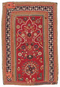
Resht Prayer Niche Embroidery, Persia, Mid 19th C., 3'4'' x 5'2''Material Culture4.6(778)See Sold PriceFeb 29, 2024
67 Reproduction Railroad Pewter Uniform Coat Buttons and Tie Pins - Detroit United Lines, C&O, B&O,Rail & Road Auctions4.6(165)See Sold PriceMar 08, 2024
D'Entrecasteaux - Australia: Chart of Van Diemen's Land (New Holland). 3Trillium Antique Prints & Rare Books4.5(32)See Sold PriceFeb 24, 2024
Chinese Carved Horn Libation Cup, 19th c., H.- 3 in., W.- 4 1/2 in., D.- 3 7/8 in., Wt.- 4.875Crescent City Auction Gallery4.3(231)See Sold PriceMar 08, 2024