SoldFramed Navigational Chart Water Locations MaineFramed Navigational Chart #103 Water Locations in Maine. Penobscot Bay, Camden, and Rockport Maine. Burled wood frame. 44 inches x 31 inchesSee Sold Price
Framed Navigational Chart Water Locations MaineFramed Navigational Chart #103 Water Locations in Maine. Penobscot Bay, Camden, and Rockport Maine. Burled wood frame. 44 inches x 31 inchesSee Sold Price
Framed Navigational Chart Water Locations MaineFramed Navigational Chart #103 Water Locations in Maine. Penobscot Bay, Camden, and Rockport Maine. Burled wood frame. 44 inches x 31 inchesSee Sold Price
SoldFramed Chart, Maine-New Hampshire CoastFramed chart showing the Maine-New Hampshire coast from Cape Elizabeth to Portsmouth, dated 1963. Details include Biddeford, Portsmouth, York, Cape Neddick, Ogunquit, Wells, Saco, Kennebunkport etc. MSee Sold Price
SoldGroup of Assorted CartographsGroup of Assorted Cartographs including a group of 8 assorted navigational charts of various locations, a modern reproduction of Heinrich Bunting's Asian map in Pegasus form, a vintage map of the IslaSee Sold Price
Sold(3) FRAMED COASTAL MAINE CHARTS (2 WITH DRAWINGS)Including: Rockport and Camden Harbors with drawings of Curtis Light and the "American Eagle", in oak bullnose frame, 18 1/2" x 22 1/2"; PLUS a print taken from the 1949 chart for Monhegan Island, witSee Sold Price
SoldFRAMED 1868 CHART FOX ISLANDS THOROUGHFARE, MAINEU.S. Coast Survey, Benjamin Peirce Superintendent, 1868, Scale 20,000, in black and gold frame, matted and glazed, OS: 28 1/2" x 40", SS: 22 3/4" x 34". Damaged on left edge.See Sold Price
SoldIRISH CHARTSa set of six framed eighteenth-century charts of Irish waters. Mount and Page circa 1750. FramedSee Sold Price
SoldMid 20th C. Framed Chart of Martha's VineyardMid 20th Century framed chart of Martha's Vineyard showing the waters from Martha's Vineyard to Block Island, having gold wood frame, 36 x 43. Good condition.See Sold Price
SoldTwo framed maps of Maine depicting: Chart of BoothTwo framed maps of Maine depicting: Chart of Boothbay, Historical Map of Arcadia in English and French 53 x 29 1/2 with Damariscotta, Sheepscot and Kennebec Rivers and soundings in feet other framed HSee Sold Price
Sold1925 Gulf of Maine Framed Ocean Depth Chart1925 Gulf of Maine Framed Ocean Depth ChartSee Sold Price
SoldBoston & Maine Employee Timetables (6)A group of Boston & Maine employee timetables. Several are eelier divisional issues and one is a 1920's system wide issue. These have freight, milk and passenger train schedules, water locations, sidiSee Sold Price
SoldVintage marine navigational chart: Chesapeake BayVintage marine navigational chart: Chesapeake Bay. 37 1/2"h x 47 1/2"w framedSee Sold Price
Sold19th century chart “Wells to Cape Ann”Original US Coast and Geodetic survey chart from 1899 showing the New England coast from Cape Ann in Gloucester Mass up to Wells Maine. Identified as chart no 108. Nicely framed. 43” x 36”See Sold Price
SoldLarge Chart, Penobscot Bay to Kennebec, 1877Large framed chart showing Penobscot Bay to Kennebec entrance including several islands of Maine. Chart is labeled number 105 from the US Coastal Survey in 1877. Highlights include Round Pond, Bath, WSee Sold Price
SoldLarge Chart, Penobscot Bay to Kennebec, 1877Large framed chart showing Penobscot Bay to Kennebec entrance including several islands of Maine. Chart is labeled number 105 from the US Coastal Survey in 1877. Highlights include Round Pond, Bath, WSee Sold Price
SoldFRAMED NOAA CHART- DAMARISCOTTA, SHEEPSCOT & KENNEBECLarge Survey Map of Midcoast Maine Rivers, #13293, includes South Bristol Harbor, Christmas Cove and Boothbay, legend includes the NOAA 25th Anniversary emblem, in a blue lacquered frame with mat andSee Sold Price
Framed Modern Hand-drawn Map Fragments RecountingFramed Modern Hand-drawn Map Fragments Recounting French Involvement in The American Revolution and Four Robert Dunning Chellis Illustrated Coast of Maine Chart Prints, the four unframed.See Sold Price
SoldCasco Bay, Maine chart.Framed topography map of the Freeport, Maine area including the communities of Topsham, Brunswick, Falmouth, Yarmouth and Cumberland with a section of Casco Bay. Includes matting. Produced by the DepaSee Sold Price
SoldDougal F Anderson Framed Watercolor Of Water BasinWatercolor Of Ocean scene in Lemon Gold Frame . Cliff, Ocean And Schooner. By D.F. Anderson, A Gentle Maine Artist Much Loved By Maine's Down East Residents. 1854-1921. 12 x 16.75 inches in size. In gSee Sold Price
SoldOriginal chart showing the state of Maine.Framed, original Eldridge’s chart from 1910 showing Kennebec River to Deer Isle, Maine. Details include showing Wiscasset, Bath, Damariscotta, Camden, Rockport etc.... Newly framed in burlwood.See Sold Price
SoldWallace Nutting, Slack Water, Signed, Framed and MattedFantastic condition. Signed by Wallace Nutting in lower right.See Sold Price
Copy of Eldridge chart Gloucester to MaineHand colored later copy of George W. Eldridge’s chart “E”, Gloucester to entrance to Kennebec River, dated 1910, authorized and published to George W. Eldridge. Mounted and framed into a gold acSee Sold Price
SoldRICHARD SIGAFOOS "PLACID WATERS" SWANS ISLAND, MERICHARD SIGAFOOS "PLACID WATERS" SWANS ISLAND, ME Richard G. Sigafoos (American, 20th Century). Oil on board, "Placid Waters", Swans Island, Maine. Signed bottom right, dated 1968. Framed in two toneSee Sold Price
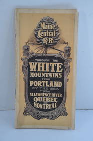
Maine Central RR Through the White Mtns-Portland to the St Lawrence River Book-1901JM Hobby Supply and Railroad Artifact Auctions4.4(126)See Sold PriceFeb 24, 2024
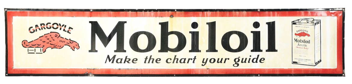
MOBILOIL "MAKE THE CHART YOUR GUIDE" PORCELAIN SIGN W/ OIL CAN & GARGOYLE GRAPHIC.Dan Morphy Auctions4.2(1.3k)See Sold PriceFeb 24, 2024
LARGE FRAMED ENGLISH PETIT POINT NEEDLEWORKThomaston Place Auction Galleries4.4(386)See Sold PriceFeb 24, 2024
LATE 18TH C. VERY LARGE CHART OF NORTHEAST CANADA BY DES BARRES (1721-1824), 1780, FRAMEDThomaston Place Auction Galleries4.4(386)See Sold PriceFeb 24, 2024
RARE 1638 HONDIUS MAP OF BERMUDA, FRAMEDThomaston Place Auction Galleries4.4(386)See Sold PriceFeb 24, 2024
CHART "LONG ISLAND SOUND FROM NEW YORK TO MONTOCK POINT ..." New York, 1830 21" x 77" sight. FramedEldred's4.7(409)See Sold PriceFeb 27, 2024
CHART "SOUTHERN COAST OF LONG ISLAND FROM MONTAUK POINT TO EAST HAMPTON" Circa 1877 11.25" x 22.75"Eldred's4.7(409)See Sold PriceFeb 27, 2024
Reynolds Thomas (1927 - 1991) Antique American Impressionist Maine Landscape Original Oil PaintingCurated Gallery Auctions4.6(120)See Sold PriceFeb 25, 2024
William A. Hill (1886 -1969) Antique American Impressionist Maine Coast Original Oil PaintingCurated Gallery Auctions4.6(120)See Sold PriceFeb 25, 2024
Philip Jamison (American,1925) Landscape Watercolor Creeds Cove SignedChina Luban Art & Antique, Inc.4.4(78)See Sold PriceFeb 24, 2024
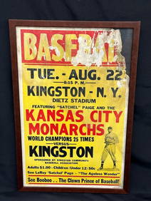
1940's Negro League Kansas City Monarchs Satchel Paige Baseball Promotional PosterDana J. Tharp Auctions4.7(268)See Sold PriceFeb 24, 2024
LARGE FRAMED PAINTED TAPESTRY THE RAISING OF LAZARUS, 64" X 47.5"Austin Auction Gallery4.7(1.2k)See Sold PriceFeb 25, 2024
Framed watercolor on paper signed Andre Derain (1880-1954)Basel Auction House4.4(43)See Sold PriceFeb 24, 2024
James Jackson Curnock Watercolor, Two Girls Gathering Water at the SpringNeue Auctions4.6(353)See Sold PriceMar 02, 2024
E.J.Baldon Signed Lake Landscape Oil PaintingThe Benefit Shop Foundation Inc.4.3(2.9k)See Sold PriceMar 20, 2024
Terry Redlin "Wild Wings Spring Fishing" - Framed Encore Print 5944/9500King's Auctions Inc4.2(121)See Sold PriceMar 03, 2024