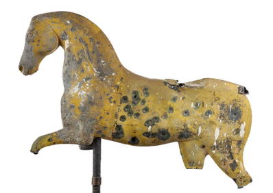
(19th c) RUNNING HORSE WEATHERVANE FRAGMENTJohn McInnis Auctioneers,LLC4.6(502)See Sold PriceFeb 25, 2024
L. Currier Richards Bronze SundialSchmidt's Antiques Inc. Since 19114.8(431)See Sold PriceMar 02, 2024
Very Rare Sundial 18 Century signed Macquart ,PARISBasel Auction House4.4(43)See Sold PriceFeb 24, 2024
Bronze Mermaid with Sea Shell Fountain SculptureHill Auction Gallery 4.7(1k)See Sold PriceFeb 28, 2024
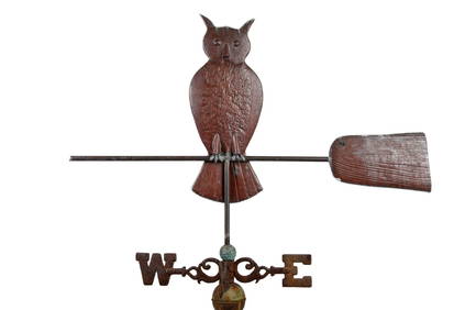
OWL on BROOM by NEW ENGLAND WEATHERVANE SHOPJohn McInnis Auctioneers,LLC4.6(502)See Sold PriceFeb 25, 2024
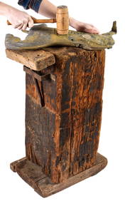
WASHBURN WEATHERVANE CO WORKSHOP SHAPING BLOCKJohn McInnis Auctioneers,LLC4.6(502)See Sold PriceFeb 25, 2024
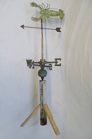
LOBSTER FORM COPPER WEATHER VANE 55"HTHOS. CORNELL GALLERIES, LTD./CORNELL AUCTIONS, OBJECTS, AND TRADE4.5(313)See Sold PriceFeb 24, 2024
(Late 19th c) FOLK ART ELEPHANT WEATHERVANEJohn McInnis Auctioneers,LLC4.6(502)See Sold PriceFeb 25, 2024
DEEP CONCRETE BIRD BATH W/ GREEK RUIN BASE 33 1/2" X 023/" WIDETHOS. CORNELL GALLERIES, LTD./CORNELL AUCTIONS, OBJECTS, AND TRADE4.5(313)See Sold PriceFeb 24, 2024
SoldLarge Chart, Penobscot Bay to Kennebec, 1877Large framed chart showing Penobscot Bay to Kennebec entrance including several islands of Maine. Chart is labeled number 105 from the US Coastal Survey in 1877. Highlights include Round Pond, Bath, WSee Sold Price
SoldLarge Chart, Penobscot Bay to Kennebec, 1877Large framed chart showing Penobscot Bay to Kennebec entrance including several islands of Maine. Chart is labeled number 105 from the US Coastal Survey in 1877. Highlights include Round Pond, Bath, WSee Sold Price
Sold1877 Chart of MaineOriginal chart of Penobscot Bay to Kennebec Entrance from 1877 by US Coastal Survey - Details include Westport Island, Southport Island, Georgetown Island, Bath, Waldoboro, Thomaston etc... Also showsSee Sold Price
1902 Chart of Penobscot Bay to Kennebec1902 Chart of Penobscot Bay to Kennebec entrance. US Coast and Geodetic Survey Chart mounted into a carved rope frame. 35 x 45See Sold Price
SoldLarge framed chart of Penobscot Bay to Machaias.Hand colored re-strike of an 1899 chart of Eldridge's Chart "G" showing Penobscot Bay and Machaias. Many details include Newbury Neck, Iron Bound Island, Schoodic Penninsula, Prospect Harbor, Dyer's NSee Sold Price
SoldOriginal 1863 Coastal Survey Chart No. 5Original 1863 marine survey of the coast of the United States, Coast Chart No. 5 featuring Penobscot Bay to Kennebec Entrance. Details include lighthouses, soundings and buoys. Framed. Overall DimensiSee Sold Price
Sold1800's Chart Showing Penobscot Bay, MaineOriginal coastal survey from 1880 detailing Penobscot Bay from Belfast to Thomaston and as far east as Deer Isle. Mounted in a silver frame. Top of chart has minor loss. Overall Dimensions: 48" H x 40See Sold Price
Sold"GEO. W. ELDRIDGE'S CHART G PENOBSCOT BAY TO MACHIAS""GEO. W. ELDRIDGE'S CHART G PENOBSCOT BAY TO MACHIAS"Dated 190130.5” x 51” sight. Framed 34.75” x 57.75”.See Sold Price
Sold19th C. Chart of "Penobscot Bay to Kennebunk19th Century chart of Maine "Penobscot Bay to Kennebunk Entrance" coasts chart #105 by the U.S. Coast survey, 46 x 35 1/2. Good condition.See Sold Price
SoldOriginal 1924 Eldridge Chart of MaineOriginal Eldridge chart 'G', Penobscot Bay to Machias, dated 1924 showing a section of the Maine coast in great detail. A real 'Downeast' chart with Blue Hill, Bar Harbor, Harrington, Jonesport, WinteSee Sold Price
SoldFrance & Spain.- Magin (Mr., Engineer to the Marine) AnFrance & Spain.- Magin (Mr., Engineer to the Marine) An Accurate Chart of the Bay of Biscay, with the Soundings, taken in 1756 & 1757, by the French Frigate Anemone ..., large chart of the Bay of BiscSee Sold Price
SoldLarge chart of San Francisco Bay 1860Heading: Author: Admiralty, British Title: N. America West Coast - San Francisco Harbour Surveyed by Lieut. James Alden U.S. Navy 1856 Place Published: London Publisher:Published at the Admiralty <See Sold Price
Spain, Portugal & Western France ports sea chart. Bay of Biscay. LARGE 1927 mapTITLE/CONTENT OF MAP: 'Ports of Spain, Portugal and Western France' DATE PRINTED: 1927 IMAGE SIZE: Approx 49.5 x 72.0cm, 19.5 x 28.25 inches (Large); Please note that this is a folding map. TYPE: AntiSee Sold Price
Spain, Portugal & Western France ports sea chart. Bay of Biscay. LARGE 1927 mapTITLE/CONTENT OF MAP: 'Russia No.9' DATE PRINTED: 1884 IMAGE SIZE: Approx 36.0 x 42.0cm, 14.25 x 16.5 inches (Large) TYPE: Antique colour atlas map CONDITION: Good; suitable for framing. However, pleaSee Sold Price
SoldFramed Navigational Chart Water Locations MaineFramed Navigational Chart #103 Water Locations in Maine. Penobscot Bay, Camden, and Rockport Maine. Burled wood frame. 44 inches x 31 inchesSee Sold Price
Framed Navigational Chart Water Locations MaineFramed Navigational Chart #103 Water Locations in Maine. Penobscot Bay, Camden, and Rockport Maine. Burled wood frame. 44 inches x 31 inchesSee Sold Price
Framed Navigational Chart Water Locations MaineFramed Navigational Chart #103 Water Locations in Maine. Penobscot Bay, Camden, and Rockport Maine. Burled wood frame. 44 inches x 31 inchesSee Sold Price
Sold1931 Chart of Chesapeake BayLarge chart showing the entrance to Chesapeake Bay. Published by the US Department of Commerce dated 1931. 39" high x 49" wide.See Sold Price
Chesapeake Bay chartLarge chart showing the entrance to Chesapeake Bay. Published by the US Department of Commerce dated 1931. Details include Cape Charles, Fisherman Island, New Pt. Comfort, Hampton Roads, York River, NSee Sold Price
Sold1877 Chart of Boston BayOriginal 1877 chart of Boston Bay and Massachusetts Bay showing the Massachusetts coast from Brant Rock in Marshfield to Cape Ann in Gloucester. Mounted in a burl wood frame. 40" x 49" overall.See Sold Price
SoldMORTIER, PIERRE. Carte Particuliere de Virginie,MORTIER, PIERRE. Carte Particuliere de Virginie, Maryland, Pennsilvanie, la Nouvelle Jarsey Orient et Occidentale. Large double-page engraved chart of the Chesapeake Bay. 25x37 inches sheet size, wideSee Sold Price
SoldGAME TABLE WITH NAUTICAL CHART TILE CENTERCustom Maine-Made Contemporary Cherry Card Table with nine-tile center depicting Penobscot Bay, Midcoast Maine, Owl's Head to Frenchman's Bay, 27" high x 30" square. Fine condition.See Sold Price
Large 19th Century Antique French Bronze Sculpture by A CarrierSan Diego Art Auction4.3(9)See Sold PriceFeb 24, 2024
LATE 18TH C. VERY LARGE CHART OF NORTHEAST CANADA BY DES BARRES (1721-1824), 1780, FRAMEDThomaston Place Auction Galleries4.4(386)See Sold PriceFeb 24, 2024
LARGE LATE 17TH C. DUTCH CHART OF CANADA, GREAT LAKES, NEW FRANCE, LABRADOR, HUDSON BAY, BY PIERREThomaston Place Auction Galleries4.4(386)See Sold PriceFeb 24, 2024
LARGE EARLY 18TH C. DUTCH CHART OF UPPER NORTH AMERICA, PIERRE MORTIER (1661-1711), FRAMEDThomaston Place Auction Galleries4.4(386)See Sold PriceFeb 24, 2024
CHART "SOUTHERN COAST OF LONG ISLAND FROM MONTAUK POINT TO EAST HAMPTON" Circa 1877 11.25" x 22.75"Eldred's4.7(409)See Sold PriceFeb 27, 2024
Danish Modern Modular 2 Bay Wall Unit by Lyby Mobler c. 1960sBidhaus4.3(747)See Sold PriceFeb 24, 2024
Llane Beach Cadaques Landscape Litho after DaliHill Auction Gallery 4.7(1k)See Sold PriceFeb 28, 2024
Large Signed 1877 Augustus Jules Bouvier Watercolor PaintingAuction Plus, Inc.4.3(4)See Sold PriceMar 01, 2024
ORIGINAL FITZ HUGH LANE (1804-1865) NATIONAL GALLERY OF ART EXHIBITION POSTER, 34IN x 42IN (86cm xThe Rug Life4.3(12)See Sold PriceMar 07, 2024
West Indies Windward Lesser Antilles. Martinique (Belonging to France)Jasper524.5(9.8k)See Sold PriceFeb 27, 2024
1764 Bellin Chart of Three South Haitian Bays -- Carte des Bayes du Mesle des Flamands et deJasper524.5(9.8k)See Sold PriceFeb 27, 2024
South Namibia coast. Walvis Bay-Orange River ADMIRALTY sea chart 1881 (1954) mapJasper524.5(9.8k)See Sold PriceFeb 28, 2024
Perry, Matthew C. 1856 Large Map. Shah Bay, Lew Chew I. JapanAlbion Auctions4.6(336)See Sold PriceMar 01, 2024
Joseph Stella (1877 - 1946) American/Italy/FranceCutler Bay Auctions4.5(168)See Sold PriceFeb 29, 2024
Fitz Henry Lane - Owls Head, Penobscot Bay MaineFederal Assets Auctioneers4.4(411)See Sold PriceFeb 26, 2024
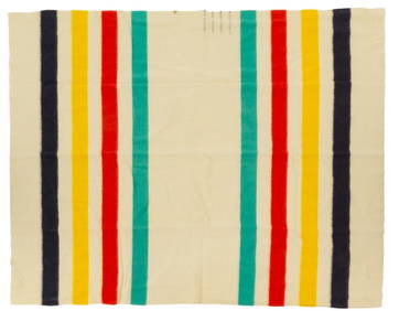
Hudson Bay Co. Wool Blanket, 7 ft. 8 in. x width 6 ft.Vogt Auction Texas4.5(597)See Sold PriceFeb 24, 2024