ATLAS of ANTIENT GEOGRAPHY by SAMUEL BUTLER 1843John McInnis Auctioneers,LLC4.6(502)See Sold PriceFeb 24, 2024
18TH C. ANTIQUE MAP: FRENCH & INDIAN WAR, FRAMEDThomaston Place Auction Galleries4.4(386)See Sold PriceFeb 24, 2024
Rand McNally Railroad Map Cabinet w/ 21 Railroad MapsRail & Road Auctions4.6(165)See Sold PriceMar 08, 2024
Keith Haring - Ink on New York Map, Best Buddies, Inscribed, Signed, and DatedSapphire Auction Gallery4(67)See Sold PriceMar 02, 2024
LATE 17TH C. FRENCH MAP OF THE NEW WORLD BY ALEXIS-HUBERT JAILLOT (1632-1712)Thomaston Place Auction Galleries4.4(386)See Sold PriceFeb 24, 2024
Central Railroad of New Jersey Map of Sandy Hook Route-ca. 1903JM Hobby Supply and Railroad Artifact Auctions4.4(126)See Sold PriceFeb 24, 2024
Lot of Six Mixed Atlas Box Cars-HO Scale-New in BoxJM Hobby Supply and Railroad Artifact Auctions4.4(126)See Sold PriceFeb 25, 2024
Rand McNally/Santa Fe Railroad Map of Iowa-1912JM Hobby Supply and Railroad Artifact Auctions4.4(126)See Sold PriceFeb 24, 2024
NICOLAES VISSCHER (NETHERLANDS, 1618-1709) MAP OF THE NEW WORLDThomaston Place Auction Galleries4.4(386)See Sold PriceFeb 24, 2024
17TH C. WORLD MAP BY NICOLAES VISSCHER (NETHERLANDS, 1618-1709)Thomaston Place Auction Galleries4.4(386)See Sold PriceFeb 24, 2024
Lot of Six Mixed Atlas Cabooses-HO Scale-New in BoxJM Hobby Supply and Railroad Artifact Auctions4.4(126)See Sold PriceFeb 25, 2024
Sold1836 Tanner Map of Egypt -- Egypt &c.Title/Content of Map: 1836 Tanner Map of Egypt -- Egypt &c. Cartographer: H S Tanner Year/Place: 1836, Philadelphia Size: 14 x 11.5 in. This is a detailed regional map of Egypt, centered on the Nile.See Sold Price
1836 Tanner Map of Egypt -- Egypt &c.Title/Content of Map: 1836 Tanner Map of Egypt -- Egypt &c. Date: 1836, Philadelphia Cartographer: H S Tanner Size: 14 x 11.5 in. This is a detailed regional map of Egypt, centered on the Nile. The maSee Sold Price
1836 Tanner Map of Egypt -- Egypt &c.Reserve Reduced! Title/Content of Map: 1836 Tanner Map of Egypt -- Egypt &c. Date: 1836, Philadelphia Cartographer: H S Tanner Size: 14 x 11.5 in. Detailed regional map of Egypt, centered on the Nile.See Sold Price
1836 Tanner Map of Egypt -- Egypt &c.Title/Content of Map: 1836 Tanner Map of Egypt -- Egypt &c. Date: 1836, Philadelphia Cartographer: H S Tanner Size: 14 x 11.5 in. Detailed regional map of Egypt, centered on the Nile. The map shows reSee Sold Price
1836 Tanner Map of Egypt -- Egypt &c.Title/Content of Map: 1836 Tanner Map of Egypt -- Egypt &c. Date Printed: 1836, Philadelphia Cartographer: H S Tanner Size: 14 x 11.5 in. Detailed regional map of Egypt, centered on the Nile. The mapSee Sold Price
1836 Tanner Antique Map of EgyptTitle/Content of Map: 1836 Tanner Map of Egypt -- Egypt &c. Date Printed: 1836, Philadelphia Cartographer: H S Tanner Size: 14 x 11.5 in. Detailed regional map of Egypt, centered on the Nile. The mapSee Sold Price
Tanner: Map of Egypt, 18361836 Tanner Map of Egypt -- Egypt &c.. Detailed regional map of Egypt, centered on the Nile. The map shows remarkable detail as to rivers, islands, mountains, gulfs, bays, deserts, towns, trading routSee Sold Price
Tanner Map of Egypt, 1836Cartographer: H S Tanner Year/Place of Publishing: 1836, Philadelphia Tanner Map of Egypt, 1836. Detailed regional map of Egypt, centered on the Nile. The map shows remarkable detail as to rivers, islSee Sold Price
1836 Tanner Map Of EgyptMap by H S Tanner, 1836, Philadelphia, 14 x 11.5 in. Detailed regional map of Egypt, centered on the Nile. The map shows remarkable detail as to rivers, islands, mountains, gulfs, bays, deserts, townsSee Sold Price
SoldTanner: Antique Map of Egypt, 1843Title/Content of Map: Egypt by Tanner Date Printed: 1843 Cartographer: Based on the work of H.C. Tanner Material/Medium: Paper Size: 17" x 14" Hand colored engraved Map. From the first edition publishSee Sold Price
Egypt &C.Title/Content of Map: Egypt &C. Date: c1834 Cartographer: TANNER, HENRY SCHENCK Publisher: H.S. TANNER Size: 14.25Height - 11.6Width The Nile is traced south to Nubia (Sudan) showing both modern and aSee Sold Price
Palmer: Map of Egypt. The Bible Atlas, 1836Map of Egypt. The Bible Atlas. Palmer, Richard. This plate: Egypt. New York, 1836. Original lithograph with hand coloring. Sheet size: 8 1/4 x 5 in. Please note that this lot has a confidential reservSee Sold Price
Sold1836 Tanner Map of West IndiesTitle: 1836 Tanner Map of West Indies -- West Indies Cartographer: H S Tanner Origin/Date: 1836, Philadelphia Size: 11 inches x 14 inches This highly informative map of the West Indies provides considSee Sold Price
Sold1836 Tanner Map of IowaTitle/Content of Map: 1836 Tanner Map of Iowa -- Iowa Date Printed: 1836, Philadelphia Cartographer: H S Tanner Size: 15 x 12.8 This great map of Iowa Territory depicts just a handful of color-coded cSee Sold Price
Sold1836 Tanner Map of Europe -- EuropeTitle/Content of Map: 1836 Tanner Map of Europe -- Europe Date: 1836, Philadelphia Cartographer: H S Tanner Size: 11.9 x 14.8 in. An attractive Map of Europe, color coding the countries. Both today'sSee Sold Price
1836 Tanner Map of Prussia / Northern Germany1836 Tanner Map of Prussia / Northern Germany -- Prussia. H S Tanner, 1836, Philadelphia, An attactive map Prussia, showing topographical and settlement details. The states are color-coded. There is aSee Sold Price
Sold1836 Tanner map of Switzerland1836 Tanner map of Switzerland. Antique map of Switzerland comes from the 1st edition of the New Universal Atlas by H.S. Tanner. The New Universal Atlas was published in 1836 in Philadelphia USA. TheSee Sold Price
Sold1836 Tanner Map of Prussia / Northern Germany --Title/Content of Map: 1836 Tanner Map of Prussia / Northern Germany -- Prussia Cartographer: H S Tanner Size: 12 x 14.7 in. An attactive map Prussia, showing topographical and settlement details. TheSee Sold Price
1836 Tanner Map of Prussia / Northern Germany --Reserve Reduced! Title/Content of Map:1836 Tanner Map of Prussia / Northern Germany -- Prussia Date:1836, Philadelphia Cartographer:H S Tanner Size:12 x 14.7 in. An attactive map Prussia, showing topoSee Sold Price
Sold1836 Tanner Map of Mississippi -- A New Map ofTitle/Content of Map: 1836 Tanner Map of Mississippi -- A New Map of Mississippi with its Roads & Distances. Cartographer: H Tanner Year/Place: 1836, Philadelphia Size: 13.2 X 11.6 in. This is a handsSee Sold Price
Sold1836 TANNER MAP OF WASHINGTON D.C.1836 TANNER MAP OF WASHINGTON D.C.: Hand colored copper engraving of Washington D. C., published 1836 by H. S. (Henry Schenck) Tanner. Sight size 12" x 15", matted and framed under glass, 18 3/8" x 21See Sold Price
1836 Tanner Map of Mississippi -- A New Map ofTitle/Content of Map: 1836 Tanner Map of Mississippi -- A New Map of Mississippi with its Roads & Distances. Date: 1836, PhiladelphiaCartographer: H Tanner Size: 13.2 X 11.6 in. This is a handsome mapSee Sold Price
DAVID ROBERTS - Holy Land / Syria / Egypt etc. 3 x Folio Volumes 1849 Very RareLuis Porretta Fine Arts4.3(10)See Sold PriceMar 02, 2024
1849 Mitchell School ATLAS 24 MAPS America Holy Land France Africa Egypt AsiaSchilb Antiquarian Rare Books4.8(421)See Sold PriceMar 31, 2024
1880 Niles Boat Egypt Voyages Sphinx Pyramids Valley of Kings Illustrated MAPSSchilb Antiquarian Rare Books4.8(421)See Sold PriceMar 31, 2024
NORTH AFRICA OF BABRBARY V Parts of Tripoli & Egypt. Libya Tribes. SDUK 1846 mapJasper524.5(9.8k)See Sold PriceFeb 28, 2024
NORTH AFRICA BARBARY. Parts of Tripoli (Libya) & Egypt. Tribes. SDUK 1844 mapJasper524.5(9.8k)See Sold PriceFeb 28, 2024
NORTH AFRICA BARBARY. Parts of Tripoli (Libya) & Egypt. Tribes. SDUK 1844 mapJasper524.5(9.8k)See Sold PriceFeb 28, 2024
NILE VALLEY. Upper & Lower. Egypt Sinai Nubia Sudan Abyssinia. BLACKIE 1886 mapJasper524.5(9.8k)See Sold PriceFeb 28, 2024
NORTH AFRICA OF BABRBARY V Parts of Tripoli & Egypt. Libya Tribes. SDUK 1851 mapJasper524.5(9.8k)See Sold PriceFeb 28, 2024
NORTH AFRICA. Morocco Algeria Tunis Tunisia Egypt. Cairo. BARTHOLOMEW 1912 mapJasper524.5(9.8k)See Sold PriceFeb 28, 2024
NORTH AFRICA. Morocco Algeria Tunis Tunisia Egypt. Cairo. BARTHOLOMEW 1901 mapJasper524.5(9.8k)See Sold PriceFeb 28, 2024
NILE VALLEY. Upper & Lower. Egypt Sinai Nubia Sudan Abyssinia. BLACKIE 1882 mapJasper524.5(9.8k)See Sold PriceFeb 28, 2024
NORTH AFRICA. Barbary. Morocco Tunisia Libya Egypt. 'Barbarie'. MALLET 1683 mapJasper524.5(9.8k)See Sold PriceFeb 28, 2024
EGYPT SUDAN ABYSSINIA. Alexandria; Eastern Continuation; Aden 1907 old mapJasper524.5(9.8k)See Sold PriceFeb 28, 2024
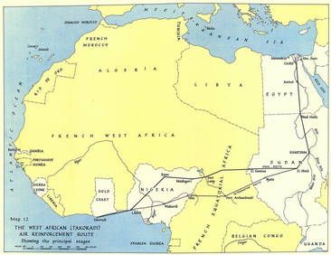
West Africa WW2 Nigeria Sudan Egypt. Takoradi air reinforcement route 1954 mapJasper524.5(9.8k)See Sold PriceFeb 28, 2024
NORTH AFRICA BARBARY. Parts of Tripoli (Libya) & Egypt. Tribes. SDUK 1848 mapJasper524.5(9.8k)See Sold PriceFeb 28, 2024
NUBIA. 'Nubie'. Nile Valley. Sudan Ethiopia Egypt. MALLET 1683 old antique mapJasper524.5(9.8k)See Sold PriceFeb 28, 2024
Egypte, Nubie et Abissinie. Egypt, Nubia & Abyssinia. Sudan. BONNE 1788 mapJasper524.5(9.8k)See Sold PriceFeb 28, 2024
Henri-Joseph Redouté - Large Folio Botanical Print - Plants in Egypt - Fagonia latifoliaProverde Auctions4.3(3)See Sold PriceFeb 28, 2024