ATLAS of ANTIENT GEOGRAPHY by SAMUEL BUTLER 1843John McInnis Auctioneers,LLC4.5(505)See Sold PriceFeb 24, 2024
18TH C. ANTIQUE MAP: FRENCH & INDIAN WAR, FRAMEDThomaston Place Auction Galleries4.4(394)See Sold PriceFeb 24, 2024
Rand McNally Railroad Map Cabinet w/ 21 Railroad MapsRail & Road Auctions4.6(165)See Sold PriceMar 08, 2024
Keith Haring - Ink on New York Map, Best Buddies, Inscribed, Signed, and DatedSapphire Auction Gallery4.1(67)See Sold PriceMar 02, 2024
LATE 17TH C. FRENCH MAP OF THE NEW WORLD BY ALEXIS-HUBERT JAILLOT (1632-1712)Thomaston Place Auction Galleries4.4(394)See Sold PriceFeb 24, 2024
Central Railroad of New Jersey Map of Sandy Hook Route-ca. 1903JM Hobby Supply and Railroad Artifact Auctions4.4(127)See Sold PriceFeb 24, 2024
Lot of Six Mixed Atlas Box Cars-HO Scale-New in BoxJM Hobby Supply and Railroad Artifact Auctions4.4(127)See Sold PriceFeb 25, 2024
Rand McNally/Santa Fe Railroad Map of Iowa-1912JM Hobby Supply and Railroad Artifact Auctions4.4(127)See Sold PriceFeb 24, 2024
NICOLAES VISSCHER (NETHERLANDS, 1618-1709) MAP OF THE NEW WORLDThomaston Place Auction Galleries4.4(394)See Sold PriceFeb 24, 2024
17TH C. WORLD MAP BY NICOLAES VISSCHER (NETHERLANDS, 1618-1709)Thomaston Place Auction Galleries4.4(394)See Sold PriceFeb 24, 2024
Lot of Six Mixed Atlas Cabooses-HO Scale-New in BoxJM Hobby Supply and Railroad Artifact Auctions4.4(127)See Sold PriceFeb 25, 2024
SoldAntique topographical map of Dockum, J Bleau from 1649,Antique topographical map of Dockum, J Bleau from 1649, 41x54 cmSee Sold Price
Lloyd: Topographical Railway Map of North America, 1867Map: Lloyd's Topographical Railway Map of North America or the United States Continent 1867 Cartographer: J. T. Lloyd Publisher: J. T. Lloyd Date: 1867 Size: 56 x 60 inches Huge antique wall map in raSee Sold Price
Blaeu: Antique Bird's-eye view of Steenvoorde, 1649Title/Content of Map: 1649 Blaeu Bird's-eye view of Steenvoorde -- Illustrissimo viro domino Eustachio Pantaleoni de la viefville, Dom. De Steenvoorde Date Printed: 1649, Amstredam Cartographer: J BlaSee Sold Price
Blaeu: Antique Bird's-eye view of Steenvoorde, 1649Title/Content of Map: 1649 Blaeu Bird's-eye view of Steenvoorde -- Illustrissimo viro domino Eustachio Pantaleoni de la viefville, Dom. De Steenvoorde Date Printed: 1649, Amstredam Cartographer: J BlaSee Sold Price
Sold3 Historic European booksGroup of three historic European books. Item 1: Hamburg, Topographical, Political and Historical, Volume Two, by J. L. von Hess, 1789, 410 pages in German. Book with 3 fold-out maps of Hamburg. CreaseSee Sold Price
Antique Topographical Map of the Rocky MountainsTitle/Content of Map: Topographical Map of Part of the Main Range Of the Rocky Mountains Publication Date: 1903-1907 ca. Authors: TOPOGRAPHICAL SURVEYS BRANCH, DEPARTMENT OF THE INTERIOR CANADA, WHEELSee Sold Price
SoldAntique topographical map, Tjietjerkstra part, printedAntique topographical map, Tjietjerkstra part, printed in the 18th century, 45x43 cmSee Sold Price
Sold2 antique topographical maps, descriptio Frisiae2 antique topographical maps, descriptio Frisiae Liberae, Mesone Alting & from 725, 32x42 cm eachSee Sold Price
SoldAN ANTIQUE MAP, "Topographical Map for Commerce ofAN ANTIQUE MAP, "Topographical Map for Commerce of Dallas, Texas," 1890, engraving on paper, published by William A. Flamm & Co., Baltimore, Maryland. 24 1/2" x 19" Provenance: Property from a FortuneSee Sold Price
SoldAN ANTIQUE AMERICAN TOPOGRAPHICAL MAP PRINT CharlesAN ANTIQUE AMERICAN TOPOGRAPHICAL MAP PRINT Charles Blaskowitz. Map 76 cm x 52 cm.See Sold Price
SoldANTIQUE FLORIDA MAP, J & C Walker, 20 x 16 inches,ANTIQUE FLORIDA MAP, J & C Walker, 20 x 16 inches, overall framed size 22 x 18 inchesSee Sold Price
SoldAntique Map Burgundy BleauUnframed hand-colored engraved map, Utriusque Burgundiae, by William Janszoon Blaeu (Dutch, 1571-1638), sheet: 19.75''h x 22.25''wSee Sold Price
SoldPartial atlas: (13) antique maps by J.G. SchreiberPartial atlas: (13) antique maps by J.G. Schreiber, 18th century, larger: 8.5" x 11.5", unframedSee Sold Price
SoldAN ANTIQUE MAP, "General Topographical Map, SheetAN ANTIQUE MAP, "General Topographical Map, Sheet XXII," WASHINGTON D.C., 1891-1895, lithograph on paper, from Atlas to Accompany the Official Records of the Union and Confederate Armies, plate CLVII,See Sold Price
SoldANTIQUE MAP, MEXICO, BY J. WELLS., NY. PRINTED FROANTIQUE MAP, MEXICO, BY J. WELLS., NY. PRINTED FROM MCNALLYS SYSTEM OF GEOGRAPHY, MAP 20. APPX. 11.75" X 14".GOOD COND.See Sold Price
SoldA 1662 J. BLEAU MAP OF THE DNIEPER RIVERA 1662 J. BLEAU MAP OF THE DNIEPER RIVER. Comprising an early map of the Dnieper River entitled "Tractus Borysthenis Vulgo Dniepr" by Dutch cartographer Joan Blaeu. The map shows the upper part of thSee Sold Price
SoldA 1660 J. BLEAU MAP OF SOUTHERN RUSSIAA 1660 J. BLEAU MAP OF SOUTHERN RUSSIA. Comprising an early map of Russia entitled "Rvssiae Vulgo Moscovia Australis" by Dutch cartographer Joan Bleau. The map displays colored border lines and threeSee Sold Price
Soldantique, maps, China, Asia, J. Wilkes(lot of 5) Unframed maps of China, including works by J. Wilkes, Herman Moll, J. Archer, T. Jefferys, and J. Fisher, largest overall: 12.5''h x 13.625''wSee Sold Price
SoldBritish America. Shows Hudson's Bay Company Forts MapBritish America. Shows Hudson's Bay Company Forts.canada Tallis/rapkin, 1849 Map. Approx 27.0 x 33.5cm, 10.5 x 13.25 inches (Large); Please note that this is a folding map. Antique engraved map by J RSee Sold Price
SoldSYRIA. Levant Palestine Jordan Lebanon Israel Cyprus.TITLE/CONTENT OF MAP: 'Syria' Vignettes: Arabs; Jerusalem DATE PRINTED: 1851 IMAGE SIZE: Approx 36.5 x 26.5cm, 14.5 x 10.25 inches (Large) TYPE: Antique engraved map by J Rapkin, published by John TalSee Sold Price
SoldBritish Isles: C England Wales Scotland Ireland MapBritish Isles: Counties. England Wales Scotland Ireland. Tallis/rapkin 1851 Map. Vignettes: London; Edinburgh; Dublin. Approx 36.5 x 26.5cm, 14.5 x 10.25 inches (Large). Antique engraved map by J RapkSee Sold Price
Tartary Siam Persia Cabool Cochinchina East Indies MapAsia. Tartary Siam Persia Cabool Cochinchina East Indies.tallis/rapkin, 1849 Map. Approx 26.0 x 33.0cm, 10.25 x 13 inches (Large); Please note that this is a folding map. Antique engraved map by J RapSee Sold Price
SoldTwo Early Framed Engraved MapsA lot of two early hand-colored engraved maps to include a W. J. Bleau map of Amsterdam, ca. 1634-1635, "Sabaudia Ducatus Savoye", together with a John Speed map of Britain, ca. 1611-1614, "DevonshireSee Sold Price
Jesenske & Mucha's Ballady a Pisne - Ornately Bound Volume with Frontispiece illustrated by MuchaTrillium Antique Prints & Rare Books4.5(33)See Sold PriceFeb 24, 2024
Audubon - Blue-grey Flycatcher. 70Trillium Antique Prints & Rare Books4.5(33)See Sold PriceFeb 24, 2024
Audubon - Fork-tailed Flycatcher. 52Trillium Antique Prints & Rare Books4.5(33)See Sold PriceFeb 24, 2024
Audubon - Chuck-will's Widow. 41Trillium Antique Prints & Rare Books4.5(33)See Sold PriceFeb 24, 2024
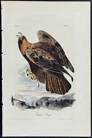
Audubon - Common Osprey Fish Hawk. 15Trillium Antique Prints & Rare Books4.5(33)See Sold PriceFeb 24, 2024
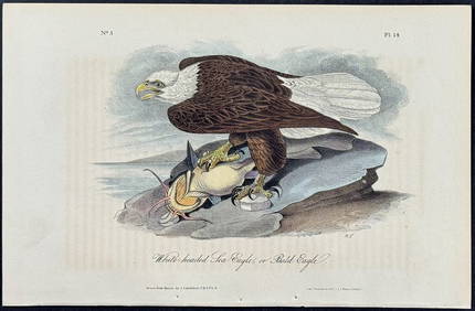
Audubon - White-headed Sea Eagle or Bald Eagle. 14Trillium Antique Prints & Rare Books4.5(33)See Sold PriceFeb 24, 2024
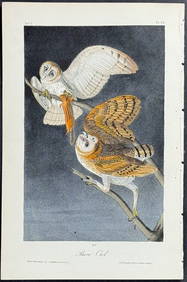
Audubon - Little Screech Owl. 40Trillium Antique Prints & Rare Books4.5(33)See Sold PriceFeb 24, 2024
NORTHERN AFRICA. Morocco Tunisia Algeria. Caravan routes. RAPKIN/TALLIS 1851 mapJasper524.5(9.9k)See Sold PriceFeb 28, 2024
NORTHERN AFRICA. Morocco Tunisia Algeria. Caravan routes.TALLIS/RAPKIN 1851 mapJasper524.5(9.9k)See Sold PriceFeb 28, 2024
NORTHERN AFRICA. Morocco Tunisia Algeria. Caravan routes. RAPKIN/TALLIS 1851 mapJasper524.5(9.9k)See Sold PriceFeb 28, 2024
Clarke & Neele 1815 Map. Europe - Recent Political ChangesAlbion Auctions4.7(341)See Sold PriceMar 01, 2024
James Cook - Antique map Australia titled 'Gezigt van het Eil. Suffren'. Antique map of SuffrenProverde Auctions4.3(3)See Sold PriceFeb 28, 2024
Antique Map - Views on the coast of Asia. J. Webber del. Engraved after J. Webber and W. Bligh.Proverde Auctions4.3(3)See Sold PriceFeb 28, 2024