ATLAS of ANTIENT GEOGRAPHY by SAMUEL BUTLER 1843John McInnis Auctioneers,LLC4.5(494)See Sold PriceFeb 24, 2024
18TH C. ANTIQUE MAP: FRENCH & INDIAN WAR, FRAMEDThomaston Place Auction Galleries4.4(386)See Sold PriceFeb 24, 2024
Rand McNally Railroad Map Cabinet w/ 21 Railroad MapsRail & Road Auctions4.6(165)See Sold PriceMar 08, 2024
Keith Haring - Ink on New York Map, Best Buddies, Inscribed, Signed, and DatedSapphire Auction Gallery3.9(67)See Sold PriceMar 02, 2024
LATE 17TH C. FRENCH MAP OF THE NEW WORLD BY ALEXIS-HUBERT JAILLOT (1632-1712)Thomaston Place Auction Galleries4.4(386)See Sold PriceFeb 24, 2024
Central Railroad of New Jersey Map of Sandy Hook Route-ca. 1903JM Hobby Supply and Railroad Artifact Auctions4.4(126)See Sold PriceFeb 24, 2024
Lot of Six Mixed Atlas Box Cars-HO Scale-New in BoxJM Hobby Supply and Railroad Artifact Auctions4.4(126)See Sold PriceFeb 25, 2024
Rand McNally/Santa Fe Railroad Map of Iowa-1912JM Hobby Supply and Railroad Artifact Auctions4.4(126)See Sold PriceFeb 24, 2024
NICOLAES VISSCHER (NETHERLANDS, 1618-1709) MAP OF THE NEW WORLDThomaston Place Auction Galleries4.4(386)See Sold PriceFeb 24, 2024
17TH C. WORLD MAP BY NICOLAES VISSCHER (NETHERLANDS, 1618-1709)Thomaston Place Auction Galleries4.4(386)See Sold PriceFeb 24, 2024
Lot of Six Mixed Atlas Cabooses-HO Scale-New in BoxJM Hobby Supply and Railroad Artifact Auctions4.4(126)See Sold PriceFeb 25, 2024
Map of Northeastern Pennsylvania. | Map of NorthwesternTitle/Content of Map: Map of Northeastern Pennsylvania. | Map of Northwestern Pennsylvania | Map Of Southeastern Pennsylvania | Map Of Southwestern Pennsylvania Cartographer: [RAND, MCNALLY & CO.] DatSee Sold Price
Map of Northeastern Pennsylvania. | Map of NorthwesternTitle: Map of Northeastern Pennsylvania. | Map of Northwestern Pennsylvania | Map Of Southeastern Pennsylvania | Map Of Southwestern Pennsylvania Prublication Date: 1883 Cartographer: [RAND, MCNALLY &See Sold Price
Sold(4) 1838 Bradford Maps: NY, PA, NYC, Phila.[United States/NY/PA/Phila] 4 Maps. ++ NEW YORK State. ++ NEW YORK City. [Street grid of central & southern Manhattan and northwestern Brooklyn.] ++ PENNSYLVANIA. ++ PHILADELPHIA. ++ Maps 14, 15, 17,See Sold Price
SoldColton's Africa Maps [Africa]Three Colton's Africa Maps; one North Eastern Africa, one North Western Africa and one South Africa. J. H. Colton Cartographer. Published by J. H. Colton, New York. Stamped 'Entered according to Act oSee Sold Price
Reconnoissance Survey northwestern Pennsylvania sheetTitle/Content of Map: Reconnoissance Survey northwestern Pennsylvania sheet Cartographer: HEARN, W. EDWARD/G. M. MAC NIDER Date: 1908 Publisher: U.S. Department of Agriculture Bureau of Soils; [NC] StSee Sold Price
Africa North Eastern sheet. | Africa north westernReserve Reduced! Map Title: Africa North Eastern sheet. | Africa north western sheet. | Africa southern sheet. Date: 1855 Cartographer: COLTON, GEORGE WOOLWORTH Publisher: J.H. Colton & Co. Size (inchSee Sold Price
Sold12 maps of northeastern states. Asher & Adams, et[United States: Mid-Atlantic]. 12 Maps. ++ 7 maps: Asher & Adams' (1) Pennsylvania And New Jersey, (2) New York And Part Of Ontario, (3) New Hampshre, Vermont, Massachusetts, Rhode Island, And ConnectSee Sold Price
SoldMAP - Balkans & Italy. Mercator/HondiusNorthwestern Balkans & Northeastern Italy. Mercator/Hondius, Forum Iulium, Karstia. Carniola, Histria Etc., 1610 (published). Hand Color. Charming small map of the northern tip of the Adriatic Sea andSee Sold Price
MAP - Greece & Turkey. OrteliusNortheastern Greece & Northwestern Turkey. Abraham Ortelius, Thraciae Veteris Typus, 1624 (published). Black & White. Handsome map of ancient Thrace based on Gastaldi's 1560 map of South East Europe,See Sold Price
SoldRailroad Photos, Postcards, Maps & MoreRailroad Photos, Postcards, Maps & More: 1.) World's Fair items: 1934 Chicago & Northwestern booklet; The Great Rock Island Route "World's Fair" Line 1891 (could be a reprint); Pennsylvania RR New YorSee Sold Price
SoldBartholomew, John 1922 Lot of 4 Large Maps of India"North Western Section" "North Eastern Section" "Southern Section" and "Provinces of the Lower Ganges" Large Lithograph Map Published 1922 by The Times, London for "The Times Survey Atlas of the WorldSee Sold Price
MAP - Northern Arizona, Grand Canyon. DuttonNorthern Arizona, Grand Canyon. Clarence Edward Dutton, [On 4 Sheets] Geologic Map of the Southern Part of the Kaibab Plateau - Part I. North-Western Sheet [and] ... Part II North-Eastern Sheet [and]See Sold Price
Vandermaelen: Antique Map of Northwest Europe, 1827TITLE/CONTENT OF MAP: 'Europe - Royaume des Pays-Bas - No 13 ' The north-western part of continental Europe, including modern-day Belgium and the Netherlands, western Germany, and north-eastern FranceSee Sold Price
Bartholomew, John 1922 Lot of 4 Large Maps of India"North Western Section" "North Eastern Section" "Southern Section" and "Provinces of the Lower Ganges" Large Lithograph Map Published 1922 by The Times, London for "The Times Survey Atlas of the WorldSee Sold Price
Europe. Royaume des Pays-Bas #13 NW Europe Benelux Germany VANDERMAELEN 1827 mapTITLE/CONTENT OF MAP: 'Europe - Royaume des Pays-Bas - No 13' The north-western part of continental Europe, including modern-day Belgium and the Netherlands, western Germany, and north-eastern FranceSee Sold Price
THE CAUCASUS & ARMENIA. Circassia Georgia Armenia. Azerbaijan. WELLER 1863 mapTITLE/CONTENT OF MAP: 'Europe - Royaume des Pays-Bas - No 13' The north-western part of continental Europe, including modern-day Belgium and the Netherlands, western Germany, and north-eastern FranceSee Sold Price
Sold8 color maps: Asia & Africa, 19th C.[Africa]. 8 color maps. ++ 5 from Colton Atlas, c.1855. 14 1/4 x 11 1/8. Includes: 2 titled Africa: North Western Sheet; and 3 titled Africa: North Eastern Sheet. ++ Other 3 from Johnson's Family AtlaSee Sold Price
Royaume des Pays-Bas #13 NW Europe Benelux Germany.TITLE/CONTENT OF MAP: 'Europe - Royaume des Pays-Bas - No 13 ' The north-western part of continental Europe, including modern-day Belgium and the Netherlands, western Germany, and north-eastern FranceSee Sold Price
"Royaume des Pays-Bas" #13 NW Europe Benelux Germany.TITLE/CONTENT OF MAP: 'Europe - Royaume des Pays-Bas - No 13 ' The north-western part of continental Europe, including modern-day Belgium and the Netherlands, western Germany, and north-eastern FranceSee Sold Price
"Royaume des Pays-Bas" #13 NW Europe Benelux Germany.Title/Content of Map: 'Europe - Royaume des Pays-Bas - No 13 ' The north-western part of continental Europe, including modern-day Belgium and the Netherlands, western Germany, and north-eastern FranceSee Sold Price
Sold19Pcs Antique Maps PENNSYLVANIA MAPS ACCOMPANYING THEDetails: This lot consists of the “Pennsylvania Maps Accompanying the Report of the Secretary of Internal Affairs on the Boundaries of the Commonwealth, 1887â€. Nineteen large folding maps aSee Sold Price
SoldThomson: Antique Map Northeastern United States, 1817Northern Provinces of the United States The beautifully detailed and colored northern United States map from Thomson's New General Atlas, with a lovely inset view of "the Great Falls of Niagara.'" CarSee Sold Price
SoldState of Pennsylvania Map 1796 from the latestArtist: Reid, John ; Winterbotham, W. after a map drawn by D. Martin Title: The State of Pennsylvania. from the latest Surveys. D. Martin sct. Publish'd by J. Reid, New York. Date: 1796 Medium: engravSee Sold Price
Sold1756 Thomas Kitchin Pennsylvania Map1756 British map titled "A Map of the Province of Pennsylvania", French & Indian War era engraved map of the Province of Pennsylvania by Thomas Kitchin printed for R. Baldwin appearing in the DecemberSee Sold Price
Crams Township and Railroad Map of Pennsylvania-1898JM Hobby Supply and Railroad Artifact Auctions4.4(126)See Sold PriceFeb 24, 2024
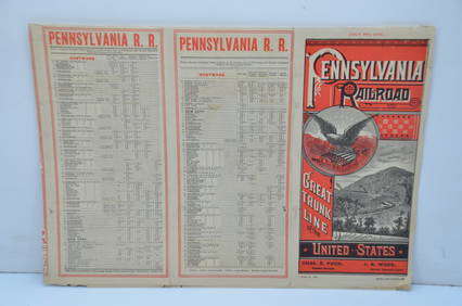
Pennsylvania Railroad July 8, 1885 Public TimetableJM Hobby Supply and Railroad Artifact Auctions4.4(126)See Sold PriceFeb 24, 2024
1888 Hand Book of the Pennsylvania Lines Containing Maps of Principal Cities - First EditionRail & Road Auctions4.6(165)See Sold PriceMar 07, 2024
1855 Guide for the Pennsylvania Railroad with an Extensive Map from the Pennsylvania RailroadRail & Road Auctions4.6(165)See Sold PriceMar 07, 2024
1876 The Centennial Exhibition Pennsylvania Railroad Worlds Fair Guide with Map and Trade CardRail & Road Auctions4.6(165)See Sold PriceMar 07, 2024
1904 Pennsylvania Railroad Winter Excursions Book with Fold Out MapRail & Road Auctions4.6(165)See Sold PriceMar 07, 2024
Pair of Early Railroad Maps - 1874 Delaware, Lackawanna & Western and 1876 Pennsylvania RailroadRail & Road Auctions4.6(165)See Sold PriceMar 07, 2024
Pair of Early Railroad Maps - 1862 Pittsburgh, Ft. Wayne & Chicago Railway and 1873 PennsylvaniaRail & Road Auctions4.6(165)See Sold PriceMar 07, 2024
1764 MAP OF COUNTRIES THIRTY MILES ROUND LONDON antique 12.5 by 15"Jasper524.5(9.7k)See Sold PriceFeb 27, 2024
1822 MAP of LEEWARD ISLANDS GEOGRAPHICAL STATISTICAL HISTORICAL antique 17.5x22"Jasper524.5(9.7k)See Sold PriceFeb 27, 2024
1822 MAP of NORTH & SOUTH AMERICA GEOGRAPHICAL STATISTICAL HISTORICAL antiqueJasper524.5(9.7k)See Sold PriceFeb 27, 2024
1822 MAP of CHILI GEOGRAPHICAL STATISTICAL HISTORICAL antique 17.5x 22" CHILEJasper524.5(9.7k)See Sold PriceFeb 27, 2024
West Africa. Liberia Sahara Senegambia Guinea. Mountains of Kong COLTON 1869 mapJasper524.5(9.7k)See Sold PriceFeb 28, 2024
North west Africa. Liberia inset. Sahara Senegambia Guinea. COLTON 1863 mapJasper524.5(9.7k)See Sold PriceFeb 28, 2024
George F. Cram - Historical Map of Pittsburgh Allegheny PennsylvaniaProverde Auctions4.3(3)See Sold PriceFeb 28, 2024
Vintage Street Map of Pittsburgh, Pennsylvania - Rand McNallyProverde Auctions4.3(3)See Sold PriceFeb 28, 2024
Monmouth, Illinois Vintage Topography MapRapid Estate Liquidators and Auction Gallery4.5(1.1k)See Sold PriceFeb 28, 2024
Antique Pennsylvania Map Fragment incl Wellersburg and New CentervilleCordier Auctions4.4(1.5k)See Sold PriceMar 02, 2024


![Colton's Africa Maps [Africa] (1 of 4)](https://p1.liveauctioneers.com/5755/154409/77936954_1_x.jpg?height=282&quality=70&version=1573094011)