ATLAS of ANTIENT GEOGRAPHY by SAMUEL BUTLER 1843John McInnis Auctioneers,LLC4.5(505)See Sold PriceFeb 24, 2024
18TH C. ANTIQUE MAP: FRENCH & INDIAN WAR, FRAMEDThomaston Place Auction Galleries4.4(393)See Sold PriceFeb 24, 2024
Rand McNally Railroad Map Cabinet w/ 21 Railroad MapsRail & Road Auctions4.6(165)See Sold PriceMar 08, 2024
Keith Haring - Ink on New York Map, Best Buddies, Inscribed, Signed, and DatedSapphire Auction Gallery4.1(67)See Sold PriceMar 02, 2024
LATE 17TH C. FRENCH MAP OF THE NEW WORLD BY ALEXIS-HUBERT JAILLOT (1632-1712)Thomaston Place Auction Galleries4.4(393)See Sold PriceFeb 24, 2024
Central Railroad of New Jersey Map of Sandy Hook Route-ca. 1903JM Hobby Supply and Railroad Artifact Auctions4.4(127)See Sold PriceFeb 24, 2024
Lot of Six Mixed Atlas Box Cars-HO Scale-New in BoxJM Hobby Supply and Railroad Artifact Auctions4.4(127)See Sold PriceFeb 25, 2024
Rand McNally/Santa Fe Railroad Map of Iowa-1912JM Hobby Supply and Railroad Artifact Auctions4.4(127)See Sold PriceFeb 24, 2024
NICOLAES VISSCHER (NETHERLANDS, 1618-1709) MAP OF THE NEW WORLDThomaston Place Auction Galleries4.4(393)See Sold PriceFeb 24, 2024
17TH C. WORLD MAP BY NICOLAES VISSCHER (NETHERLANDS, 1618-1709)Thomaston Place Auction Galleries4.4(393)See Sold PriceFeb 24, 2024
Lot of Six Mixed Atlas Cabooses-HO Scale-New in BoxJM Hobby Supply and Railroad Artifact Auctions4.4(127)See Sold PriceFeb 25, 2024
Map and Profile of the Tejon Pass;Title: Map and Profile of the Tejon Pass; Date: 1861 Cartographer: WILLIAMSON, ROBERT STOCKTON/JOHN GRUBB PARKE Publisher: WAR DEPARTMENT Size: 22.25Height - 33.75Width from explorations and surveys dSee Sold Price
Map and Profile of the Tejon Pass;Title: Map and Profile of the Tejon Pass; Publication Date: 1861 Cartographer: WILLIAMSON, ROBERT STOCKTON/JOHN GRUBB PARKE Publisher: WAR DEPARTMENT Size: 22 X 33.6 Additional Information: "from explSee Sold Price
Map and Profile of the Tejon Pass;...1853Title/Content of Map: Map and Profile of the Tejon Pass;...1853 Date Printed: 1861 Cartographer: WILLIAMSON, LT. R.S. Material/Medium: WAR DEPARTMENT Size: 22X33.6 Map showing explorations and surveysSee Sold Price
Pacific Railroad Survey routes in CaliforniaTitle: Two maps of Pacific Railroad Survey routes in California Author: Williamson, R.S., John G. Parke, et al. Description: Includes: Map and Profile of the Tejon Pass ... 1853. 55x86 cm (21¾x33¾")See Sold Price
SoldPacific Railroad Survey routes in CaliforniaTitle: Two maps of Pacific Railroad Survey routes in California Author: Williamson, R.S., John G. Parke, et al. Description: Includes: Map and Profile of the Tejon Pass ... 1853. 55x86 cm (21¾x33¾")See Sold Price
Pacific Railroad Survey routes in CaliforniaTitle: Two maps of Pacific Railroad Survey routes in California Author: Williamson, R.S., John G. Parke, et al. Description: Includes: Map and Profile of the Tejon Pass ... 1853. 55x86 cm (21¾x33¾")See Sold Price
Map and Profile of the Tejon Pass;...1853Publication Date: 1861 Title: Map and Profile of the Tejon Pass;...1853 Cartographer: WILLIAMSON, LT. R.S. Publisher: WAR DEPARTMENT Height: 22 Width: 33.6 Map showing explorations and surveys for a rSee Sold Price
Sold1853 Geological Map of Passes by St. Gabriel Mountains,Title: 1853 Geological Map of Passes by St. Gabriel Mountains, CA -- Geological Map of the Tejon Pass & Canada de las Unas Including the Pass of San Franciscoquito & Williamson's Pass Cartographer: WSee Sold Price
Geological Map of Passes by St. Gabriel Mountains, CATitle/Content of Map: 1853 Geological Map of Passes by St. Gabriel Mountains, CA -- Geological Map of the Tejon Pass & Canada de las Unas Including the Pass of San Franciscoquito & Williamson's Pass DSee Sold Price
Geological Map of Passes by St. Gabriel Mountains, 1853Title: 1853 Geological Map of Passes by St. Gabriel Mountains, CA -- Geological Map of the Tejon Pass & Canada de las Unas Including the Pass of San Franciscoquito & Williamson's Pass Cartographer: WSee Sold Price
1853 Geological Map of Passes by St. Gabriel Mountains,Title/Content of Map: 1853 Geological Map of Passes by St. Gabriel Mountains, CA -- Geological Map of the Tejon Pass & Canada de las Unas Including the Pass of San Franciscoquito & Williamson's Pass DSee Sold Price
SoldBOARD OF WATER SUPPLY NEW YORK MAP & PROFILE 1909Board of Water Supply of the City of New York, Catskill Aqueduct Map and Profile. Manner of delivering the water to the several boroughs. November 15, 1909. Litho by Chas. Hart, 36 Vessey St. NY. MeasSee Sold Price
Sold1898 Rapid Transit Commission Map & Profile Of RailRapid Transit Commission Map & Profile Of Railway. 15 3/4 x 34.See Sold Price
SoldCarl Hoerman, Below Tejon PassCarl Hoerman (American, 1885-1955) Below Tejon Pass oil on artist board signed lower right 18" x 20"See Sold Price
Sold1854 Map - Profiles1854 Map - Profiles - From San Francisco Bay to Los Angeles Cal and from the Pimas Villages to Fort Fillmore''. Measures approx. 24''H x 46''W. Under shrink wrap on card Board. Some minor tearing on tSee Sold Price
Framed Map Passes and Harbor West Coast FranceMap depicting the passes and harbor of Lorient in the west coast France. Framed and under glass approx. 45" x 33".See Sold Price
SoldCalifornia 1856 Lot of 7 Large Railroad Survey ChartsIncl Sierra Nevada, Tejon Pass, Tejon Ravine, Bernardino Sierra/San Pedro, Colorado Desert, Bernardino Pass, Colorado River, and Coast Mountains from San Francisco to the Great Basin. Lithographs PublSee Sold Price
SoldPlan for a Canal, Chicago's Lake to Missisippi RiverTitle/Content of Map: 1890 US Corps of Engineers Plan for a Canal from Chicago's Lake Front to Missisippi River -- Map & Profile of the Proposed Routes for a Waterway Between Lake Michigan & MississipSee Sold Price
SoldMap of the Rutland & Burlington Railroad 1848Title: Map & Profile of the Rutland & Burlington Railroad Author: Gilbert, W.S. Description: Lithographed map. 59.5x136 cm. (23½53½"), on three sheets joined together. Early railroad map tracing theSee Sold Price
Rand McNally/Santa Fe Railroad Map of Iowa-1912JM Hobby Supply and Railroad Artifact Auctions4.4(127)See Sold PriceFeb 24, 2024
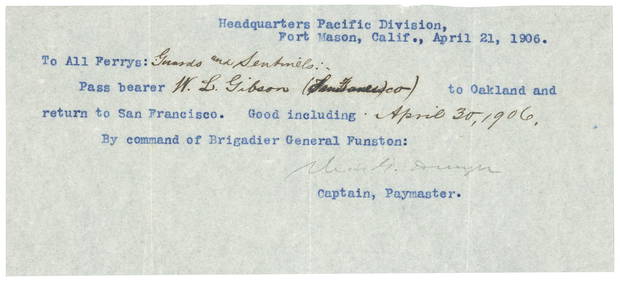
Lehigh Valley RR 1891 PassJM Hobby Supply and Railroad Artifact Auctions4.4(127)See Sold PriceFeb 24, 2024
Mahanoy and Broad Mountain RR 1866 PassJM Hobby Supply and Railroad Artifact Auctions4.4(127)See Sold PriceFeb 24, 2024
ROBERT BROWNING Rare 1902 LE "Pippa Passes" Calf Binding 1st EdLuis Porretta Fine Arts4.3(10)See Sold PriceMar 02, 2024
18TH C. ANTIQUE MAP: FRENCH & INDIAN WAR, FRAMEDThomaston Place Auction Galleries4.4(393)See Sold PriceFeb 24, 2024
Keith Haring - Ink on New York Map, Best Buddies, Inscribed, Signed, and DatedSapphire Auction Gallery4.1(67)See Sold PriceMar 02, 2024
Three Delaware & Hudson Canal Company Railroad Annual Passes - 1884, 1885, and 1886Rail & Road Auctions4.6(165)See Sold PriceMar 08, 2024
Four White Pass & Yukon Route Playing Card DecksRail & Road Auctions4.6(165)See Sold PriceMar 08, 2024
Rand McNally Railroad Map Cabinet w/ 21 Railroad MapsRail & Road Auctions4.6(165)See Sold PriceMar 08, 2024
Putnam - First Map of the State of Ohio by Rufus PutnamTrillium Antique Prints & Rare Books4.5(32)See Sold PriceFeb 24, 2024
Peter Max Mixed Media Blend Painting Woodstock Series Profile on Board One of Three in Sale SignedHess Fine Auctions4.5(210)See Sold PriceJun 15, 2024