Zoning map of Pasadena Cal., 1940
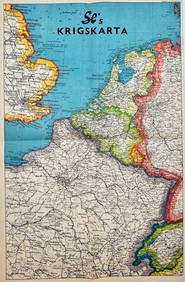
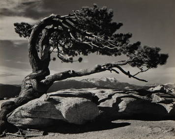
Occupied Japan Lacquer Book Cover w. chip-carved map/Japan on back Buddha on FrontMar 13, 2024Peter Stoyan (Stoyanoff) (1900-1979) Canadian Listed Engraving 1940 PortraitMar 02, 202410 Books including: Oswald, Assassin or Fall Guy, A Soldier of the Sky, The Proselyte &+Feb 28, 2024PANERAI Radiomir 1940 Equation of Time 8 Days Acciaio Mens WatchFeb 23, 2024Private aviation airport at Hunter's PointMar 07, 2024Folding map of the East Bay, 1913Mar 07, 2024Folding map of Glenn County Cal., 1914Mar 07, 2024Pocket map of Humboldt County Cal. 1914Mar 07, 2024Folding map of Placer County Cal., 1914Mar 07, 2024Folding map of San Benito County Cal., 1914Mar 07, 2024Street map of San Diego, Cal., 1914Mar 07, 2024San Francisco map for motorists, 1915Mar 07, 2024Pictorial map of ribald San Francisco 1940Mar 07, 2024Street map of Stockton CaliforniaMar 07, 2024Folding map of Tehama County Cal., 1914Mar 07, 2024Weber's folding map of Tulare County Cal.1914Mar 07, 2024Large folding map of Tuolumne County 1914Mar 07, 2024SECOND WORLD WAR AFRICA. European colonies & German mandates 1940 old mapFeb 28, 2024CURTIUS RUFUS QUINTUS, SIXTEENTH-CENTURY ELZEVIER HISTORIARUM LIBRI W/ MAP 16.33Mar 03, 2024Vintage Map - På Vakts Krigskarta över Norden / On Vakt's war map of the Nordic region, SecondFeb 28, 2024Vintage Map - Krigskarta - War Map - Second World War, published 1940Feb 28, 2024Mostly U.S., Some Canada Maps etc (40 Pcs)Mar 06, 2024Vintage 40's New Jersery Souvenir TableclothMar 07, 2024Ansel Adams (1902 - 1984): Jeffrey Pine, Sentinel Dome, YosemiteMar 09, 2024