ATLAS of ANTIENT GEOGRAPHY by SAMUEL BUTLER 1843John McInnis Auctioneers,LLC4.5(505)See Sold PriceFeb 25, 2024
18TH C. ANTIQUE MAP: FRENCH & INDIAN WAR, FRAMEDThomaston Place Auction Galleries4.4(393)See Sold PriceFeb 24, 2024
Rand McNally Railroad Map Cabinet w/ 21 Railroad MapsRail & Road Auctions4.6(165)See Sold PriceMar 08, 2024
Keith Haring - Ink on New York Map, Best Buddies, Inscribed, Signed, and DatedSapphire Auction Gallery4(67)See Sold PriceMar 02, 2024
LATE 17TH C. FRENCH MAP OF THE NEW WORLD BY ALEXIS-HUBERT JAILLOT (1632-1712)Thomaston Place Auction Galleries4.4(393)See Sold PriceFeb 24, 2024
Central Railroad of New Jersey Map of Sandy Hook Route-ca. 1903JM Hobby Supply and Railroad Artifact Auctions4.4(127)See Sold PriceFeb 24, 2024
Lot of Six Mixed Atlas Box Cars-HO Scale-New in BoxJM Hobby Supply and Railroad Artifact Auctions4.4(127)See Sold PriceFeb 25, 2024
Rand McNally/Santa Fe Railroad Map of Iowa-1912JM Hobby Supply and Railroad Artifact Auctions4.4(127)See Sold PriceFeb 24, 2024
NICOLAES VISSCHER (NETHERLANDS, 1618-1709) MAP OF THE NEW WORLDThomaston Place Auction Galleries4.4(393)See Sold PriceFeb 24, 2024
17TH C. WORLD MAP BY NICOLAES VISSCHER (NETHERLANDS, 1618-1709)Thomaston Place Auction Galleries4.4(393)See Sold PriceFeb 24, 2024
Lot of Six Mixed Atlas Cabooses-HO Scale-New in BoxJM Hobby Supply and Railroad Artifact Auctions4.4(127)See Sold PriceFeb 25, 2024
SoldUnusual U. S. map showing two topog. profilesInteresting hand colored map of America showing many western states in early border configurations. Unusual feature shows topographical profiles from two different latitudes. Few small fox spots. WithSee Sold Price
SoldRare c1780s U. S. map showing FrankliniaRare and unusual map of the United States showing early borders of various states. The seller has not been able to locate another copy of this map. The map appears to either be a source for, or copy oSee Sold Price
EIGHTEEN LUOHANSTwo paintings (pair) on silk, several collector seals. China, Ming Dynasty A somewhat unusual painting emanating humor, with notable skillful brushwork in the faces, showing us two times nine Luohan.See Sold Price
EIGHTEEN LUOHANSTwo paintings (pair) on silk, several collector seals. China, Ming Dynasty A somewhat unusual painting emanating humor, with notable skillful brushwork in the faces, showing us two times nine Luohan.See Sold Price
SoldCarte Des Etats-Unis, 1856Map: Carte Des Etats-Unis Maker: Louis Etienne Dussieux Date: 1856 Size: Folio - 11 inches high x 15.25 inches wide "Grave par Marlier." U.S. map from his Atlas Generale showing unusual Western territSee Sold Price
SoldTwo US one dollar misprints & three silver certsA very unusual quartered US 1981A Dollar bill misprint showing four corners, a 1977 A with a misprint folded corner overlay on the bottom left, three 1957 A & B Silver Certificates plus one 1935F SilvSee Sold Price
TRENCH ART U-BOAT DESK DISPLAYTRENCH ART U-BOAT DESK DISPLAY An unusual piece of trench art, most likely German made, a desk display, approx. 8 ¾" x 4 ¼" x 3", depicting an aluminum U-boat in profile before two aluminum lighSee Sold Price
SoldTwo 1950 Samplers history of transportation depictsTwo 1950 Samplers history of transportation depicts a US map with all modes of transport, ship, horses, buggy, bicycle, circa 1955 My Country map of US with all kinds of activities,showing skiers steaSee Sold Price
Map of US & Canada w/ad for Anchor Line on versoTitle: Map of the United States and Canada, Showing the more important places in the two Countries, especially the Cities and Towns to which Passengers can be Booked Through by the Steamers of the "AnSee Sold Price
SoldNantucket Map, c. 1890Two U.S. geological survey topographical chart maps framed and matted together, showing Nantucket Tuckernuck and Muskeget,c.1890, Overall, 35” x 45”See Sold Price
SoldTwo Pocket Maps of California (117240)Two pocket maps: "Complete Map of California," "Showing principal automobile roads," (handwritten, "after 1909"). Electric lines, railroads, M.O. post office, banks, rivers, canals, and last U.S. CensSee Sold Price
SoldTwo Pocket Maps of California (117240)Two pocket maps: "Complete Map of California," "Showing principal automobile roads," (handwritten, "after 1909"). Electric lines, railroads, M.O. post office, banks, rivers, canals, and last U.S. CensSee Sold Price
SoldCivil War Military Map of the U.S. - 1862Excellent example of the more desirable of the two extant variants of this map. This variant, showing a layout of the states rather than military zones, offers a wonderful insight into the political sSee Sold Price
Two Ship Blueprints1932 Chapelle Blueprints of U.S.S. Wasp. Noted maritime historian Howard Chapelle blueprints showing the U.S.N. sloop of war Wasp of 1806. The first blueprints shows inboard profile and deck plan. TheSee Sold Price
Johnson's New Military Map of the U.S. - 1862Reserve Reduced! Excellent example of the more desirable of the two extant variants of this map. This variant, showing a layout of the states rather than military zones, offers a wonderful insight intSee Sold Price
SoldTwo Ship Blueprints1932 Chapelle Blueprints of U.S.S. Wasp. Noted maritime historian Howard Chapelle blueprints showing the U.S.N. sloop of war Wasp of 1806. The first blueprints shows inboard profile and deck plan. TheSee Sold Price
SoldWorld War II: OkinawaA remarkable map entitled "Okinawa Shima" showing the northern part of Okinawa Island, prepared by US Tenth Army Engineers on August 8, 1945, just two days after Hiroshima and one day before Nagasaki.See Sold Price
World War II: OkinawaA remarkable map entitled "Okinawa Shima" showing the northern part of Okinawa Island, prepared by US Tenth Army Engineers on August 8, 1945, just two days after Hiroshima and one day before Nagasaki.See Sold Price
Sold19TH C MAPS BY ORRIN POTTER U.S. and CONNECTICUTTWO EARLY 19TH C MAPS BY ORRIN POTTER: 1) Map of CONNECTICUT by Orrin Potter, Plymouth 1816, with key showing roads, county lines, court houses, meeting houses, and mountains, 19" x 14 1/2". 2) detailSee Sold Price
SoldTwo 19th Century North Carolina Coastal MapsTwo 19th Century North Carolina Coastal Mapsas follows: Sketch D Showing the progress of Section No 4 U. S. Coast Survey in 1846-47 & 48 (Washington, 1849), steel engraving of Albemarle Sound with hanSee Sold Price
SoldNETTE - Unusual MARX Tin litho Road Race setMarx, but not labeled, two tin autos, both working w/figure * up'n over set with colorful litho track showing towns all over the US, signs of playwear, but overall nice C6-7See Sold Price
Sold**Perazzi O/U 12G Combination Shotgun.Serial # 46089 This Perazzi model SC3 (MAP) two barrel set is new, unfired showing 99 plus condition. The O/U barrel set measures 30" with a raised vent rib and choked extra full with a constriction oSee Sold Price
SoldLot of 5 U.S. WWII Navy pillow coversH-164 Lot of 5 souvenir U.S. WWII Navy silk pillow covers. Includes a colorful unusual "AMPHIBIOUS TRAINING BASE LITTLE CREEK VA" showing tanks coming from the mouth of an alligator. Also two white siSee Sold Price
Lot of 5 U.S. Navy WWII silk pillow coversH-116 Lot of 5 souvenir U.S. Navy WWII silk pillow covers. Includes a colorful unusual "AMPHIBIOUS TRAINING BASE LITTLE CREEK VA" showing tanks coming from the mouth of an alligator. Also two white siSee Sold Price
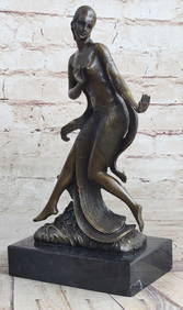
Signed Original Ancient Grecian women Bronze Sculpture Marble BaseHouse of Treasure4.3(53)See Sold PriceMar 01, 2024
Map of Part of the West Indies, Etc., Showing the Exact Position Of The U.S. War Steamer SanJasper524.5(9.9k)See Sold PriceFeb 28, 2024
RACHMANINOFF SERGEI: (1873-1943)International Autograph Auctions Europe S.L.4.5(52)See Sold PriceMar 13, 2024