ATLAS of ANTIENT GEOGRAPHY by SAMUEL BUTLER 1843John McInnis Auctioneers,LLC4.6(502)See Sold PriceFeb 24, 2024
18TH C. ANTIQUE MAP: FRENCH & INDIAN WAR, FRAMEDThomaston Place Auction Galleries4.4(386)See Sold PriceFeb 24, 2024
Rand McNally Railroad Map Cabinet w/ 21 Railroad MapsRail & Road Auctions4.6(165)See Sold PriceMar 08, 2024
Keith Haring - Ink on New York Map, Best Buddies, Inscribed, Signed, and DatedSapphire Auction Gallery4(67)See Sold PriceMar 02, 2024
LATE 17TH C. FRENCH MAP OF THE NEW WORLD BY ALEXIS-HUBERT JAILLOT (1632-1712)Thomaston Place Auction Galleries4.4(386)See Sold PriceFeb 24, 2024
Central Railroad of New Jersey Map of Sandy Hook Route-ca. 1903JM Hobby Supply and Railroad Artifact Auctions4.4(126)See Sold PriceFeb 24, 2024
Lot of Six Mixed Atlas Box Cars-HO Scale-New in BoxJM Hobby Supply and Railroad Artifact Auctions4.4(126)See Sold PriceFeb 25, 2024
Rand McNally/Santa Fe Railroad Map of Iowa-1912JM Hobby Supply and Railroad Artifact Auctions4.4(126)See Sold PriceFeb 24, 2024
NICOLAES VISSCHER (NETHERLANDS, 1618-1709) MAP OF THE NEW WORLDThomaston Place Auction Galleries4.4(386)See Sold PriceFeb 24, 2024
17TH C. WORLD MAP BY NICOLAES VISSCHER (NETHERLANDS, 1618-1709)Thomaston Place Auction Galleries4.4(386)See Sold PriceFeb 24, 2024
Lot of Six Mixed Atlas Cabooses-HO Scale-New in BoxJM Hobby Supply and Railroad Artifact Auctions4.4(126)See Sold PriceFeb 25, 2024
SoldTWO 19TH CENTURY MAPS OF ENGLAND, SCOTLAND, IRELANDIncludes an 1861 Johnson and Ward map of England and Wales, 25.5 x 17.25 inch sight size, matted. Also an unmatted map of Ireland and Scotland, also by Johnson and Ward, 1863, 18 x 26.25 inches.See Sold Price
SoldTwo Maps of Philadelphia Antique Cloth Handkerchiefs.Two 19th Century Maps of Philadelphia Cloth Handkerchiefs. Depicts a printed central map of Philadelphia surrounded by busts of Washington, franklin, Jefferson and Penn. With alternating views of theSee Sold Price
SoldWall Maps. Two rolled 19th century maps mounted onWall Maps. Two rolled 19th century maps mounted on linen, for instructional use, one of the United States, and the other of Worcester County, some cracking and discoloration.See Sold Price
Sold(2) Late 19th c. maps of Ireland, unframedTwo late 19th century colored maps of Ireland, comprising a map of Ireland printed for The Century Atlas, circa 1897, 16"h x 11"w, unframed, and a map of Ireland printed for The Society for the DiffusSee Sold Price
Sold2 Maps: Early U.S. plus Louisiana and a Polar Map, 19thTwo framed maps, 19th century. One oak framed map of United States east of the Mississippi and Louisiana and one gilt wood framed map of the polar regions.(SBAR2375/2) {PR} Measurements: Oak frame isSee Sold Price
SoldTwo Chinese scroll maps.Two late 19th / early 20th century Chinese scroll maps, printed ink on paper each measuring 47 1/2 inches x 12.See Sold Price
SoldGrp: Assorted Maps of EuropeLarge group of assorted 18th and 19th century maps of Europe. Includes two overall maps of Europe, one map of England and Wales, one map of Scotland, one map of France, one map of Greece, two maps ofSee Sold Price
SoldLot with ten Cartes De Visite, one tin type rebelLot with ten Cartes De Visite, one tin type rebel soldiers, two pieces with rebel soldiers, two Yankee soldiers, two 19th century bullets, print of Grant 1892 Boston map, and group of 19th century recSee Sold Price
SoldTHREE 19TH CENTURY MAPS OF UTAHIncludes two 'by order of the honorable the Secretary of War,' and assisted by G.K. Gilbert, A.R. Marvine, E.E. Howell, and based on expeditions of 1872 and 1873. Both with sight sizes of approximatelSee Sold Price
SoldTWO 19TH CENTURY ENGRAVINGS AFTER KARL BODMERCirca 1832-1834 The two bookplates from the Maximilian, Prince of Wied's, Travels in the interior of North America atlas, 1832-1834, titles Mandan Women and Dance of the Mandan Indians, each is publisSee Sold Price
Two 19th C. Japanese PrintsLot of two 19th century Japanese prints, depicting one continuous image of map with calligraphy, 59" h x 27 1/2" w. Provenance: From a California estate.See Sold Price
SoldCollection of approximately thirty hand coloured mapsCollection of approximately thirty hand coloured maps of the United Kingdom by various cartographers including Cary etc., together with fifteen various 19th Century American newspapersSee Sold Price
SoldTwo Chinese scroll maps.Two late 19th / early 20th century Chinese printed ink on paper scroll maps measuring 48 inches x 14.See Sold Price
SoldTwo Chinese scroll maps.Two late 19th / early 20th century Chinese printed ink on paper scroll maps measuring 48 inches x 12.See Sold Price
Sold19th Century United States Engraved Maps19th Century United States Engraved Maps Two maps including 1865 of the 'TERRITORIES & PACIFIC STATES' to accompany 'Across the Continent' by Samuel Bowles, having detailed ancillary map of 'Plan of CSee Sold Price
Sold19TH C TWO VOL BOOK SET: M HUC, JOURNEY THROUGH CHINA19TH CENTURY TWO VOLUME BOOK SET, A Journey Through the Chinese Empire, by M Huc (New York, 1856, (no previous editions noted), 8" x 5 1/2". First volume includes map. Brown cloth with gilt spine. ConSee Sold Price
SoldNine (9) Augustus Mitchell MapsCollection of late 19th century United States STATE maps including Minnesota, Iowa and Missouri, State of Maine , Illinois-Missouri-Iowa-Nebraska-and Kansas on one, Two Georgia and Alabama, ConnecticuSee Sold Price
Sold8 19th Century Literature BooksIncludes: oeuvres des Deux Corneille (Pierre et Thomas), two volumes, Charles Louandre, E. Capiomont et V. Renault. Ouvres Complete de Moliere, three volumes, Charles Louandre, E. Capiomont et V. RenaSee Sold Price
Three 19th century bois durci cases and a photo frameThree 19th century bois durci cases and a photo frame including one housing a hand coloured ambrotype with two children together with a daguerreotype of an elderly woman housed in a tooled leather casSee Sold Price
Sold"A Map of Old Philadelphia…..", 1932"A Map of Old Philadelphia on which are indicated Buildings of Architectural Interest that were built during the 18th and early 19th Centuries and are still standing AD 1932, Two Hundred and Fifty YeaSee Sold Price
SoldA 19th century French Neoclassical ormolu clock theA 19th century French Neoclassical ormolu clock the white enamelled dial marked 'Gaston Jolly A Paris', the case modelled with two seated lithe ladies consulting a map on a table, with a sphere on a pSee Sold Price
SoldArtist Unknown (American, 19th Century) MississippiArtist Unknown (American, 19th Century) Mississippi River to the Pacific Ocean. 'A Geological Map' and 'A Geological Section', two color lithographs after William P. Blake and Jules Marcou, circa 1855See Sold Price
SoldAntique Mahogany & Figural Brass Rolling Map CaseLast half of the 19th century, likely Europe. The piece having very well-cast hardware and frame with two hinged doors which folks out for display. All resting atop a cast brass acanthus and paw formSee Sold Price
SoldLARGE LOT OF EPHEMERA RELATED TO MATTAPOISETT,ROCHESTER, WAREHAM, AND MARION, MA, FROM THE 18TH, 19TH, AND 20TH CENTURIES. APPROXIMATELY 300 TOTAL PIECES. FOR MATTAPOISETT, HIGHLIGHTS INCLUDE: MEILINGS MENU, 1857 MAPS, TWO CATHAY TEMPLE MENUS, POSee Sold Price
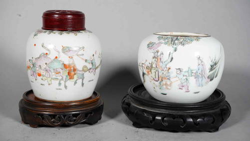
Two 19th Century Chinese Polychrome Hand-painted Porcelain Globular JarsNeo FineArts Inc4.4(12)See Sold PriceFeb 25, 2024
A 19TH CENTURY HAND COLOURED MAP OF ORKNEY AND SHETLANDHutchinson Scott Auctioneers4.4(39)See Sold PriceFeb 28, 2024
TWO 19th CENTURY DRESDEN PORCELAIN PLATTERSLewis & Maese Antiques & Auction4.4(520)See Sold PriceFeb 25, 2024
TWO 19th CENTURY JAPANESE IMARI CHARGERSLewis & Maese Antiques & Auction4.4(520)See Sold PriceFeb 25, 2024
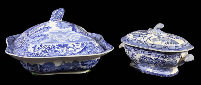
LOT OF TWO 19th CENTURY SPODE ITALIA VIEWS TUREENSLewis & Maese Antiques & Auction4.4(520)See Sold PriceFeb 25, 2024
[ENSLAVEMENT & ABOLITION]. Two 19th-century imprints, incl. anti-slavery publication The Slave'sFreeman's | Hindman4.4(1.6k)See Sold PriceFeb 27, 2024
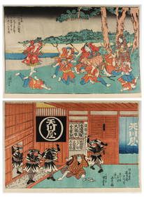
Utagawa Kuniyoshi, Two 19th Century Japanese Ukiyo-e Woodblock Prints, Kabuki TheaterHoch LTD.4.5(73)See Sold PriceFeb 25, 2024
Utagawa Kuniyoshi, Two 19th Century Japanese Ukiyo-e Woodblock Prints, Kabuki TheaterHoch LTD.4.5(73)See Sold PriceFeb 25, 2024
1704 DESCRIPTION OF ALL THE SEATS OF THE PRESENT WARS OF EUROPE antique w/ MAPSJasper524.5(9.8k)See Sold PriceFeb 27, 2024
1760 MAP CARTE PARTICULIERE DE L'ISLE DE JUAN FERNANDES antique Robinson CrusoeJasper524.5(9.8k)See Sold PriceFeb 27, 2024
1558 SCANDINAVIA SWEDEN ILLUSTRATED HISTORY Gothorum Sveonumque historia antiqueJasper524.5(9.8k)See Sold PriceFeb 27, 2024
Two 19th Century Mexican RetablosBroken Arch Auction Gallery NCFL#93994.6(294)See Sold PriceMar 04, 2024
Johnson's Africa. Colonies & tribes. Liberia Nile Delta Cape Colony 1866 mapJasper524.5(9.8k)See Sold PriceFeb 28, 2024
Two Hand-Colored 19th Century Maps of New Orleans and Louisiana, Larger- H.- 12 1/2 in., W.- 15 1/2Crescent City Auction Gallery4.3(229)See Sold PriceMar 08, 2024
Late 18th century map of England and Wales sampler and two printsFellows4.3(159)See Sold PriceMar 05, 2024
ANTIQUE ILLUSTRATED HANDBOOK OF GEOGRAPHY AND TRAVEL IN ASIA, VOLUME 2, 1896NY Elizabeth 4.3(84)See Sold PriceMar 03, 2024
THE ANTIQUE ILLUSTRATED BOOK "1856 ARCTIC EXPLORATIONS: SECOND GIRNEL EXPEDITION 2" BY E. KANENY Elizabeth 4.3(84)See Sold PriceMar 03, 2024
James Sowerby (1757 - 1822) - Set of 8 Botanical Prints - Heath Cudweed - Saxifraga Nivalis -Proverde Auctions4.3(3)See Sold PriceFeb 28, 2024
James Sowerby (1757 - 1822) - Set of 8 Botanical Prints - Birthwort, Aristolochia clematitis -Proverde Auctions4.3(3)See Sold PriceFeb 28, 2024
James Sowerby (1757 - 1822) - Set of 10 Botanical Prints -Proverde Auctions4.3(3)See Sold PriceFeb 28, 2024
James Sowerby (1757 - 1822) - Set of 10 Botanical Prints - Common Sea-Buckthorn - Orobanche RapumProverde Auctions4.3(3)See Sold PriceFeb 28, 2024
James Sowerby (1757 - 1822) - Set of 10 Botanical Prints - Orobanche Common Lesser - CentrolepisProverde Auctions4.3(3)See Sold PriceFeb 28, 2024
James Sowerby (1757 - 1822) - Set of 10 Botanical Prints - Potentilla anserina - Poa aquatica -Proverde Auctions4.3(3)See Sold PriceFeb 28, 2024


![[ENSLAVEMENT & ABOLITION]. Two 19th-century imprints, incl. anti-slavery publication The Slave's (1 of 3)](https://p1.liveauctioneers.com/197/319238/171468079_1_x.jpg?height=282&quality=70&version=1707520367)