ATLAS of ANTIENT GEOGRAPHY by SAMUEL BUTLER 1843John McInnis Auctioneers,LLC4.6(502)See Sold PriceFeb 24, 2024
18TH C. ANTIQUE MAP: FRENCH & INDIAN WAR, FRAMEDThomaston Place Auction Galleries4.4(386)See Sold PriceFeb 24, 2024
Rand McNally Railroad Map Cabinet w/ 21 Railroad MapsRail & Road Auctions4.6(165)See Sold PriceMar 08, 2024
Keith Haring - Ink on New York Map, Best Buddies, Inscribed, Signed, and DatedSapphire Auction Gallery4(67)See Sold PriceMar 02, 2024
LATE 17TH C. FRENCH MAP OF THE NEW WORLD BY ALEXIS-HUBERT JAILLOT (1632-1712)Thomaston Place Auction Galleries4.4(386)See Sold PriceFeb 24, 2024
Central Railroad of New Jersey Map of Sandy Hook Route-ca. 1903JM Hobby Supply and Railroad Artifact Auctions4.4(126)See Sold PriceFeb 24, 2024
Lot of Six Mixed Atlas Box Cars-HO Scale-New in BoxJM Hobby Supply and Railroad Artifact Auctions4.4(126)See Sold PriceFeb 25, 2024
Rand McNally/Santa Fe Railroad Map of Iowa-1912JM Hobby Supply and Railroad Artifact Auctions4.4(126)See Sold PriceFeb 24, 2024
NICOLAES VISSCHER (NETHERLANDS, 1618-1709) MAP OF THE NEW WORLDThomaston Place Auction Galleries4.4(386)See Sold PriceFeb 24, 2024
17TH C. WORLD MAP BY NICOLAES VISSCHER (NETHERLANDS, 1618-1709)Thomaston Place Auction Galleries4.4(386)See Sold PriceFeb 24, 2024
Lot of Six Mixed Atlas Cabooses-HO Scale-New in BoxJM Hobby Supply and Railroad Artifact Auctions4.4(126)See Sold PriceFeb 25, 2024
1851 Tallis Map of Islands in the Indian Ocean --Title/Content of Map: 1851 Tallis Map of Islands in the Indian Ocean -- Islands in the Indian Ocean Date: 1851, London Cartographer: J Tallis Size: 8.8 x 12 in. This is an excellent map featuring theSee Sold Price
1851 Tallis Map of Islands in the Indian Ocean --Reserve Reduced! Title/Content of Map: 1851 Tallis Map of Islands in the Indian Ocean -- Islands in the Indian Ocean Date: 1851, London Cartographer: J Tallis Size: 8.8 x 12 in. This is an excellent mSee Sold Price
1851 Tallis Map of Islands in the Indian Ocean --Title: 1851 Tallis Map of Islands in the Indian Ocean -- Islands in the Indian Ocean Date: 1851, London Cartographer: J Tallis Size: 8.8 x 12 in. Additional Information: This is an excellent map featuSee Sold Price
1851 Tallis Map of Islands in the Indian Ocean --Title/Content of Map: 1851 Tallis Map of Islands in the Indian Ocean -- Islands in the Indian Ocean Date: 1851, London Cartographer: J Tallis Size: 8.8 x 12 in. This is an excellent map featuring theSee Sold Price
1851 Tallis Map of Islands in the Indian Ocean --Title/Content of Map: 1851 Tallis Map of Islands in the Indian Ocean -- Islands in the Indian Ocean Date: 1851, London Cartographer: J Tallis Size: 8.8 x 12 in. This is an excellent map featuring theSee Sold Price
1851 Tallis Map of Islands in the Indian Ocean --Title/Content of Map: 1851 Tallis Map of Islands in the Indian Ocean -- Islands in the Indian Ocean Date: 1851, London Cartographer: J Tallis Size: 8.8 x 12 in. This is an excellent map featuring theSee Sold Price
1851 Tallis Map of Islands in the Indian Ocean -- Islands in the Indian OceanTitle: 1851 Tallis Map of Islands in the Indian Ocean -- Islands in the Indian Ocean Cartographer: J Tallis Year / Place: 1851, London Map Dimension (in.): 8.8 x 12 in. This is an excellent map featurSee Sold Price
1851 Tallis Map of Islands in the Indian Ocean --Title/Content of Map: 1851 Tallis Map of Islands in the Indian Ocean -- Islands in the Indian Ocean Date: 1851, London Cartographer: J Tallis Size: 8.8 x 12 in. This is an excellent map featuring theSee Sold Price
1851 Tallis Map of Islands in the Indian Ocean --Title/Content of Map: 1851 Tallis Map of Islands in the Indian Ocean -- Islands in the Indian Ocean Date: 1851, London Cartographer: J Tallis Size: 8.8 x 12 in. This is an excellent map featuring theSee Sold Price
1851 Tallis Map of Islands in the Indian Ocean --Title/Content of Map: 1851 Tallis Map of Islands in the Indian Ocean -- Islands in the Indian Ocean Cartographer: J Tallis Year/Place: 1851, London Size: 8.8 x 12 in. This is an excellent map featurinSee Sold Price
1851 Tallis Map of Islands in the Indian Ocean --Title: 1851 Tallis Map of Islands in the Indian Ocean -- Islands in the Indian Ocean Date: 1851, London Cartographer: J Tallis Size: 8.8 x 12 in. Additional Information: This is an excellent map featuSee Sold Price
1851 Tallis Map of Islands in the Indian Ocean --Title/Content of Map: 1851 Tallis Map of Islands in the Indian Ocean -- Islands in the Indian Ocean Date: 1851, London Cartographer: J Tallis Size: 8.8 x 12 in. This is an excellent map featuring theSee Sold Price
1851 Tallis Map of Islands in the Indian Ocean -- Islands in the Indian OceanTitle: 1851 Tallis Map of Islands in the Indian Ocean -- Islands in the Indian Ocean Cartographer: J Tallis Year/Place: 1851, London Dimensions: 8.8 x 12 in. Description: This is an excellent map featSee Sold Price
1851 Tallis Map of Islands in the Indian Ocean --Title: 1851 Tallis Map of Islands in the Indian Ocean -- Islands in the Indian Ocean Date: 1851, London Cartographer: J Tallis Size: 8.8 x 12 in. Additional Information: This is an excellent map featuSee Sold Price
1851 Tallis Map of Islands in the Indian Ocean --Title: 1851 Tallis Map of Islands in the Indian Ocean -- Islands in the Indian Ocean Date: 1851, London Cartographer: J Tallis Size:8.8 x 12 in. Description: This is an excellent map featuring the NorSee Sold Price
1851 Tallis Map of Islands in the Indian Ocean --Title/Content of Map: 1851 Tallis Map of Islands in the Indian Ocean -- Islands in the Indian Ocean Date: 1851, London Cartographer: J Tallis Size: 8.8 x 12 in. This is an excellent map featuring theSee Sold Price
1851 Tallis Map of Islands in the Indian Ocean --Title: 1851 Tallis Map of Islands in the Indian Ocean -- Islands in the Indian Ocean Cartographer: J Tallis Year / Place: 1851, London Map Dimension (in.): 8.8 x 12 in. This is an excellent map featurSee Sold Price
Islands in the Indian Ocean Map, Tallis, 1851Islands in the Indian Ocean Map. The superb Atlantic Islands map from Tallis' Illustrated Atlas extending from the east coast of Africa and Madagascar to southern Indian, Ceylon, and Southeast Asia. WSee Sold Price
SoldTallis: Map of Islands in the Indian Ocean, 1851Map: Islands in the Indian Ocean Cartographer: Tallis Place & Date: London/New York / 1851 Size: 13 1/4" x 10 1/2" The superb Indian Ocean islands map from Tallis' Illustrated Atlas extending from theSee Sold Price
Islands of the Indian Ocean (Price of Wales Island),Original engraving by J. Rapkin, published by John Tallis, 1851. Gorgeous hand color with decorative border. Map features insets of the Point de Galle, Ceylon, Port Louis Mauritius, Price of Wales IslSee Sold Price
Islands of the Indian Ocean (Price of Wales Island),Original engraving by J. Rapkin, published by John Tallis, 1851. Gorgeous hand color with decorative border. Map features insets of the Point de Galle, Ceylon, Port Louis Mauritius, Price of Wales IslSee Sold Price
Islands of the Indian Ocean (Price of Wales Island),Original engraving by J. Rapkin, published by John Tallis, 1851. Gorgeous hand color with decorative border. Map features insets of the Point de Galle, Ceylon, Port Louis Mauritius, Price of Wales IslSee Sold Price
SoldTallis, John (Pub) 1852 Map Islands in the Indian OceanSteel Engraved Map with Original Outline Hand Color Published 1852-56 by John Tallis, London for "The Universal Pronouncing Dictionary" by Thomas Wright. Drawn & Engraved by John Rapkin. Centre fold aSee Sold Price
19thc Map: Islands in the Indian Ocean, J. RapkinFramed map, Islands in the Indian Ocean. Drawn and engraved by John Rapkin, 1851. Illustrations drawn and engraved by H. Winkles. Sight measurement 10.25" x 13.5". Well framed and matted under glass,See Sold Price
EARLY 18TH C. DUTCH CHART OF PACIFIC OCEAN BY FREDERIK DE WIT (1629-1706) WITH CALIFORNIA AS ANThomaston Place Auction Galleries4.4(386)See Sold PriceFeb 24, 2024
Portfolio of 15 County Maps by Robert Morden (English 1650-1703)Nadeau's Auction Gallery4.7(401)See Sold PriceFeb 24, 2024
1851 INDIANS Life & Adventures of Black Hawk Sac Keokuk Fox NATIVE AMERICAN WarSchilb Antiquarian Rare Books4.8(421)See Sold PriceMar 31, 2024
The Village–Hooper Bay, Edward S. Curtis photogravurePBA Galleries4.7(381)See Sold PriceMar 07, 2024
NORTHERN AFRICA. Morocco Tunisia Algeria. Caravan routes. RAPKIN/TALLIS 1851 mapJasper524.5(9.8k)See Sold PriceFeb 28, 2024
Carte du Canal de Mosambique…. Madagascar Bonne Esperance. BONNE 1780 mapJasper524.5(9.8k)See Sold PriceFeb 28, 2024
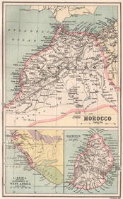
MOROCCO LIBERIA & MAURITIUS. Sierra Leone. BARTHOLOMEW 1886 old antique mapJasper524.5(9.8k)See Sold PriceFeb 28, 2024
Coste Occidentale d’Afrique…' West Africa. Gulf of Guinea. BELLIN 1746 mapJasper524.5(9.8k)See Sold PriceFeb 28, 2024
NORTHERN AFRICA. Morocco Tunisia Algeria. Caravan routes.TALLIS/RAPKIN 1851 mapJasper524.5(9.8k)See Sold PriceFeb 28, 2024
NORTHERN AFRICA. Morocco Tunisia Algeria. Caravan routes. RAPKIN/TALLIS 1851 mapJasper524.5(9.8k)See Sold PriceFeb 28, 2024
Réunion Island Stamps 1917 Four Rare OverprintRapid Estate Liquidators and Auction Gallery4.5(1.1k)See Sold PriceFeb 24, 2024
A LARGE ERRATA BOOK INDIAN MAPS AND STUDIES including the provinces of Bengal, Cossimbuzar Island, THannam's Auctioneers Ltd4.3(386)See Sold PriceFeb 27, 2024